



 ARTOAJ Home



Abstract
With advances in digital computing and satellite technology, GIS and Remote Sensing have been applied to a range of applications, including agriculture. Land-surface, weather, and socio-economic data can be merged into a GIS database to support profitable decision-making. However, due to the slow adoption of these technologies in developing countries, the advantage is not yet fully realized by those nations. Since about the year 2000-2010, free satellite data, GIS software, and internet access in developing countries have expanded opportunities to use GIS and remote sensing in agricultural practices.
Keywords: GIS; Remote Sensing; Agriculture; Developing countries; Satellite data
Abbreviations: GIS: Geographic Information Systems; RS: Remote Sensing; MODIS: Major free satellite data sources include; SAR: Synthetic Aperture Radar; IRRI: International Rice Research Institute
Introduction
Modern technology has transformed every human activity, and agriculture is one of the key sectors benefiting from this trend. The use of Geographic Information Systems (GIS) combined with Remote Sensing (RS) in agriculture, especially in precision farming, has achieved significant progress GIS People [1]. The integration of remote sensing and GIS helps identify agricultural fields that require more attention, such as through yield mapping and farm surface wetness analysis, to assess crop performance. However, this advantage in the agricultural industry is not fully accessible in developing countries due to the slow adoption of GIS and remote sensing for local applications. Since the early days of technology, scientists have noted the limited use of remote sensing and GIS in developing countries Adeniyi [2] & Perera & Tateishi [3]. If modern technology were applied efficiently in developing countries, they could make data-driven decisions to boost future yields.
How do GIS, Remote Sensing, and Agriculture link to each other?
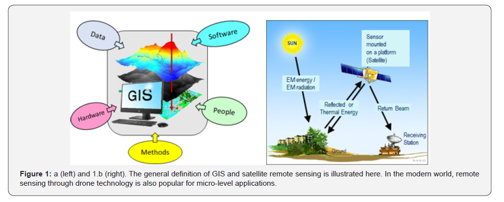
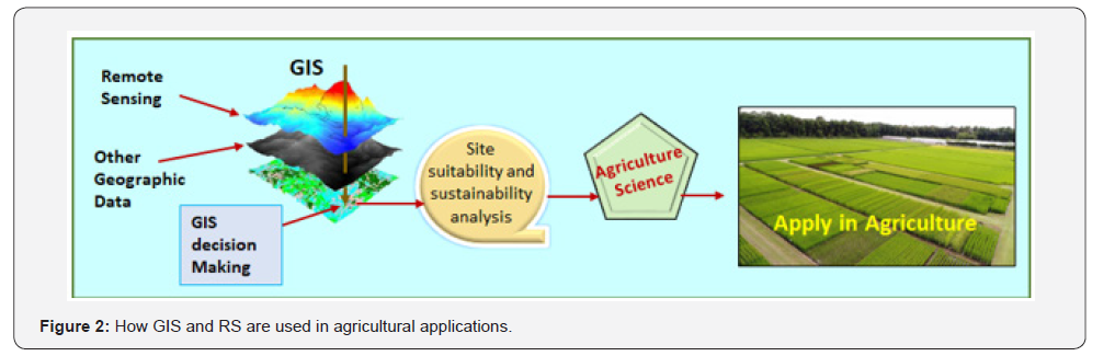
GIS (Geographic Information System) is a computer system used to capture, store, check, analyses, and display spatial information about the Earth’s surface National Geographic [4] (Figure 1a). (Figure 1b) shows the basic mechanism of satellite remote sensing, but this process has evolved to include the use of drones for local-level land observations. Because of its integration with Google Earth, GIS users in agricultural applications can examine the infrastructure and geography of crop regions more deeply. An accurate understanding of the relationship between location and ground conditions enables people to assess farming practices using precision agriculture methods, make quantitative and qualitative decisions, and share crop information with relevant services. The simplified mechanism for integrating GIS and RS for agricultural applications is presented in (Figure 2). The fundamental theory of spatial data layers (including satellite imagery-based maps) that register on top of each other facilitates the user in making various decisions about crop lands, depending on the need. How to process satellite imagery and prepare a GIS database is not addressed in this short paper.
Free access to open-source data and data processing software
Compared with the 1990s, rich free data and software environments are now available to any country. Major free satellite data sources include MODIS MODIS web [5], Sentinel-1 and Sentinel-2 ESA [6], and JAXA [7]. While MODIS provides low-resolution daily imagery, high-quality satellite radar data for agriculture is primarily available from the Sentinel-1 mission, which provides continuous, cloud-penetrating SAR (Synthetic Aperture Radar) data. Key applications of SAR data include mapping soil moisture, crop biomass, and structural monitoring ESA [6]. NASA’s Landsat historical data can be used to analyses multitemporal land-cover changes for various planning applications. Among free open-source GIS data, OpenStreetMap provides a rich GIS data platform OpenStreetMap [8]. Write about satellite data, OpenStreetMap, other GIS data, and QGIS, etc. Nearly all these data sources are georeferenced to WGS 84 (World Geodetic System 1984), the standard coordinate system, datum, and geometric spheroid model used globally for mapping, GIS, and GPS.
Applying GIS and remote sensing in agriculture
The most basic approach to applying GIS and remote sensing in agriculture begins with preparing land-suitability assessments. Since the early 1990s, such applications have started at an experimental level under limited facilities in developed countries Perera et al. [9] & Perera & Tateishi [10]. When dealing with land suitability mapping, surface biomass fluctuations, impacts of natural disasters, and yield mapping, etc., GIS and remote sensing can be utilized to develop land assessments to improve agriculture Perera & Armando [11] Perera et al. [12] & Perera et al. [13] & GIS People [1]. Using freely available current satellite data, open-source GIS data, and GIS software, applications have been developed for smartphones, a common device in both developed and developing countries. By applying real-time data on plant disease, irrigation, and soil health, the app helps farmers reduce risks, maximize resource use, and eventually increase yields Zuturu et al. [14]. Furthermore, satellite-based weather forecasting with higher accuracy and a focus on the local scale is providing hyper-local, real-time, accurate weather predictions, allowing farmers to optimize resource use, including irrigation, pest and disease control, and mitigate risks from extreme weather events and farming practices. In one of the recent case studies, Cornell University, the International Rice Research Institute (IRRI), the International Maize and Wheat Improvement Centre (CIMMYT), and the Indian Council of Agricultural Research (ICAR) found significant differences in rice yields among Indian farmers IRRI [15]. Analyzing data from over 15,800 fields, the researchers discovered that rice yields vary significantly across regions, with average yields ranging from 3.3 to 5.5 tons per hectare. The study pinpointed two critical factors affecting rice yields: use of nitrogen (N) fertilizer and irrigation practices. These causes are common across most developing countries, and, as highlighted in this short paper, the application of GIS and RS will help improve planning agricultural practices to increase crop productivity.
References
- GIS People (2025) GIS in Agriculture: Precision Farming.
- Adeniyi PO (1993) Integration of Remote Sensing and GIS for Agricultural Resource Management in Nigeria, Earsel Advances in Remote Sensing.
- Perera LK, Tateishi R (1995) Do remote sensing and GIS have a practical applicability in developing countries? (including some Sri Lankan experiences). International Journal of Remote Sensing 16(1): 35-51.
- National Geographic (2026) GIS (Geographic Information System).
- MODIS web (2026).
- (2026) ESA (European Space Agency), Sentinel-1, Radar vision for Copernicus.
- (2026) JAXA.
- OpenStreetMap (2026).
- Perera LK, Kajiwara K, Tateishi R (1993) Land Suitability Assessment for Reforestation in Southern Sri Lanka, Journal of the Japan Society of Photogrammetry and Remote Sensing 32(5): 4-12.
- Perera K, Tateishi R, Akihiko K. Herath SA (2021) Combined Approach of Remote Sensing, GIS, and Social Media to Create and Disseminate Bushfire Warning Contents to Rural Australia. Earth 2: 715-730.
- Perera LK, Kajiwara K, Tateishi R (1993) Land suitability assessment by GIS for paddy cultivation in Sri Lanka. Proceedings of IGARSS '93 - IEEE International Geoscience and Remote Sensing Symposium.
- Perera K, Herath S, Apan A, Samarakoon L (2010) Application of MODIS 250m images without in situ observations for mapping Mekong River basin land cover, International Archives of the Photogrammetry, Remote Sensing and Spatial Information Science XXXVIII (8).
- Perera K, Herath S, Apan A, Tateishi R (2012) Application of MODIS data to assess the latest forest cover changes of Sri Lanka. isprs-annals 1(7).
- Zuturu AA, Mirza MK, Agarwal T (2024) A Mobile Application for Crop Optimization using Satellite Imagery and Disease Detection using AI.
- (2024) IRRI (International Rice Research Institute), Boosting India's Rice Yields.