Potential of Agroecosystem Services. The Case of Slovakia
Makovníková Jarmila1*, Pálka Boris1, Širáň Miloš1, Kanianska Radoslava2 and Kizeková Miriam3
1National Agricultural and Food Centre/Soil Science and Conservation Research Institute Bratislava, Slovakia
2Department of Environment, Matej Bel University Banská Bystrica, Slovakia
3National Agricultural and Food Centre/Grassland and Mountain Agriculture Research Institute Banská Bystrica, Slovakia
Submission: June 07, 2017; Published: June 22, 2017
*Corresponding author: Makovníková Jarmila, National Agricultural and Food Centre/ Soil Science and Conservation Research Institute Bratislava, Regional Station Banská Bystrica, Slovakia, Email: j.makovnikova@vupop.sk
AHow to cite this article: Makovníková J, Pálka B, Širáň M, Kanianska R, Kizeková M. Potential of Agroecosystem Services. Agri Res& Tech: Open Access J. 2017; 8(1): 555727. DOI: 10.19080/ARTOAJ.2017.08.555727
Abstract
Applying the mapping of agroecosystem services potential appropriately can help to show the possibilities of regional sustainable land use management as well as trade-offs between different ecosystem services. For analysis and evaluation of potential of agroecosystem services in Slovakia, we have created a mapping unit combining four input layers: slope topography, climate units, soil texture and usage of land. The potential of provisioning services in relation to cultural services in Slovakia were evaluated. In Slovakia 29.14 % of ecosystems of agricultural land has very high potential for provisioning services. They are mainly ecosystems of arable land located in warm climate in the Danube basin. The capacity of ecosystems to provide recreational services depends on the particular uniqueness of the site, its accessibility and the surrounding infrastructure. Agroecosystems of arable land are predominantly of very low (50.7 %) to low potential (15.7%) of natural conditions for recreation. In Slovakia 53.82% of the area of used permanent grasslands has high and very high potential of natural conditions for outdoor recreation.
Introduction
Agroecosystem services are the multiple goods and services provided to humanity by nature in combination with additional anthropogenic inputs in agricultural systems [1,2]. For practical use as well as legislative use of the concept of agroecosystem services in planning and prospective studies, qualitative and quantitative analysis and evaluation of agroecosystem linked to spatial visualization at the required level are essential. Traditionally, agroecosystems have been considered primarily as sources of provisioning services, but more recently their contributions to other types of ecosystem services have been recognized [2,3], such as regulating and cultural services [4,5]. Because the provision of ecosystem services depends on biophysical conditions, land use and climatic changes [2,5], the supply and demand of services may differ geographically [6]. The mapping the potential of ecosystem services can be used to develop recommendations for sustainable land use and planning and decision making (Burg 2016). Provisioning services are mapped more frequently than regulating and cultural service (Crossman et al. 2013). From the group of cultural services is the most common mapped recreation service. The relationship between food provisioning service and recreation service is characterized by trade-offs [7], which are different in arable soils compared to grassland. At arable land, provisioning services are in contrast to cultural services [7,8]. Grasslands are considered to be not only actual providers of provisioning services but also actual providers of cultural services.
For spatial quantifying of agroecosystem services of used agricultural land in Slovakia, we have created a mapping unit combining four input layers: slope topography, climate units, soil texture and usage of land. The resulting layer (raster layer with 100 m resolution) is processed for the entire territory of the Slovak Republic with the use of methods and tools offered by geographic information systems. Layer spatial aggregate function unit is also compatible with the spatial units in international use database (Corine Land Cover) as carries information about land cover. Within each unit created space, we calculated a weighted average of the potential of each agroecosystem service for the territory of the Slovak Republic, which is characteristic for the spatial aggregate of functional unit. Evaluation of agroecosystem services linked to spatial visualization allow to optimize the management of agroecosystems, thereby to promote synergies between ecosystem functioning and the social dynamics of the region. Explicit modelling of agroecosystem services is considered to be one of the main requirements for the implementation of the concept of these services in institutional decision-making.
The potential of provisioning services in relation to cultural services in Slovakia
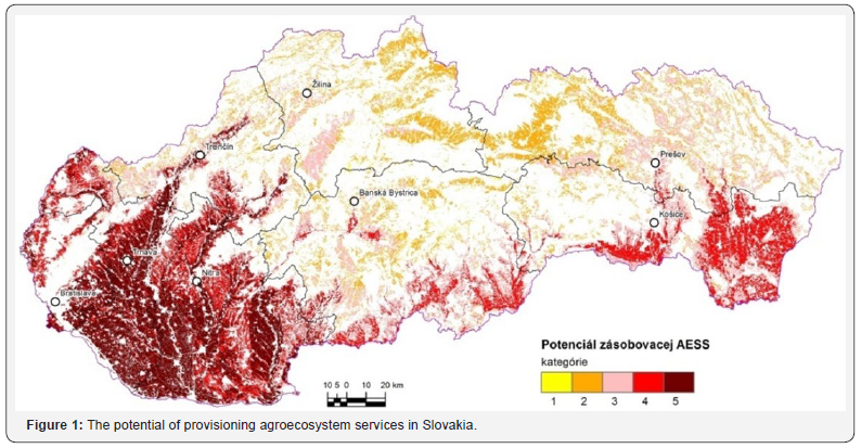
The basis for analysing the potential for the provisioning agroecosystem services was a point value (BH) of productive potential based on typological and production classification of agricultural soils of Slovakia. BH (point value)= ( HPJ+SE+KH+Z )* T, where HPJ - point value of the main soil unit, SE - inclination score and exposure score, KH - score of skeleton and soil depth , Z - texture score, T - coefficient for climatic regions. The BH value is a basis for the rationalization and environmental exploitation of natural resources of a particular territorial unit and its value in Slovakia ranges from 0 to 100. Five categories were determined: 1- very low relevant capacity, 2 - low relevant capacity, 3- medium relevant capacity, 4- high relevant capacity, 5 - very high relevant capacity [8,9] (Figure 1). The majority of the total area of Slovakia belongs to the categories of very high (29.14 %) and high potential (23.87%) for provisioning services. They are mainly ecosystems of arable land located in warm climate in the Danube basin. The low potential is present in more than 20% of the total area. The main limiting features of low potential of provisioning services are relatively cool climate and considerable sloppiness, limited depth or relatively high stoniness of ecosystem soils. In this category the predominant ecosystems are permanent grasslands. Based on correlation analysis the potential of the provisioning service is significantly affected by climate, slope, texture and altitude, and this effect is more pronounced in the ecosystems of arable land compared to grassland ecosystems. Climate has the most significant impact on agroecosystem services. Warm, dry and lowland regions have a higher potential of provisioning services in comparison to moderately warm and cold regions.

The potential for outdoor recreation. We presume that each agroecosystem has the potential (capacity) for carrying out the outdoor recreation. All agro-ecosystems are considered to be potential providers of these services. Recreation potential was evaluated through agroecosystem landscape components that have a specific link with summer, winter and year-round recreation. The recreational potential for all these activities was calculated as sum of individual recreational activities potential without added points (protected natural areas- Natura 2000) which were added only to the final sum in order to prevent multiple evaluations of additional factors [8-10]. Five categories of agroecosystems concerning providing outdoor recreational activity were determined.
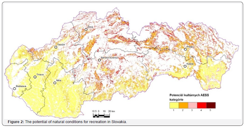
Agroecosystems of arable land are predominantly of very low to low potential of natural conditions for recreation. In Slovakia 53.82% of the area of used permanent grasslands has high and very high potential of natural conditions for outdoor recreation. Contrary to ecosystems of arable land, grassland agroecosystems are located close to protected Natura 2000 sites in areas with higher sloppiness and at higher altitude.
The majority of the total area of Slovakia belongs to the low and very low category of potential of natural conditions for recreation (66.4% of all agroecosystems). Potential of natural conditions for recreation is higher only in agroecosystems with a higher proportion of area of grassland agroecosystems and protected areas NATURA 2000. The majority of grassland (53.83%) belongs to the high and very high category of potential for recreation. The relationship between food provisioning service and environmental management of agroecosystems is characterized by trade-offs. It is important to note that agroecosystems are not able to provide agroecosystem services without any intervention by humans (human and social capital). However, increasing of primary and secondary production of agroecosystems must be managed with regard to the sustainability of the soil multi functionality and also the sustainability of potential of agroecosystem to provide ecosystem services in their integrity (Figure 2).

The capacities of grasslands to supply cultural agroecosystem services can significantly contribute to the economic stability and prosperity of a particular region, using these soils with low production potential, primary for the recreational purposes, thereby preventing degradation and loss of agricultural soil.
Acknowledgement
The authors acknowledge the Slovak Research and Development Agency for the financial support via contract No. APVV-0098-12 Analysis, modelling and evaluation of agroecosystem services.
References
- Zhang W, Ricketts TH, Kremen C, Carney K, Swinton SM (2007) Ecosystem services and disservices to agriculture. Ecological Economics 64: 253-260.
- Burkhard B, Kandziorai MS, Müller F (2014) Ecosystem Service Potentials, Flows and Demands- Concepts for Spatial Localisation, Indication and Quantification. Official Journal of the International Association for Landscape Ecology 34: 1-32.
- Walter V Reid (2005) Millennium ecosystem assessment. Ecosystems and human well-being: biodiversity synthesis. World Resources Institute, Washington, USA.
- Dominati E, Patterson M, Mackay A (2010) A framework for classifying and quantifying the natural capital and ecosystem services of soils. Ecological Economics 69: 1858-1868.
- Burkhard B, Kroll F, Nedkov S, Müller F (2012) Mapping supply, demand and budgets of ecosystem services. Ecological Indicators 21: 17-29.
- Crossman ND, Burkhard B, Nedkov S, Willemen L, Petz K, et al. (2013) A blueprint for mapping and modelling ecosystem services. Ecosystem Services 4: 4-14.
- Felipe-Lucia MR, Comin FA, Bennett EM (2014) Interactions among ecosystem services across land uses in a flood plain agroecosystem. Ecology and Society 19(1): 20.
- Makovníková J, Kanianska R, Kizeková M (2015) An approach to evaluating potential of cultural agroecosystem services. Ecology & Safety 9: 24-33.
- Makovníková J, Kobza J, Pálka B, Mališ J, Kanianska R (2016) An approach to mapping the potential of cultural agroecosystem services. Soil & Water Res 11(1): 44-52.
- Makovníková J, Kanianska R, Kizeková M (2017) The ecosystem services supplied by soil in relation to land use. Hungarian Geographical Bulletin 66(1): 1-6.


