


Abstract
The Eastern Mediterranean Sea supports significant fishing activity across eight coastal states, yet regional analyses of fishing effort distribution across all coastal states remain scarce. This study analyzes spatio-temporal patterns of fishing effort in the Eastern Mediterranean using Global Fishing Watch (GFW) Automatic Identification System (AIS) data covering January 2024 through December 2025 (24 months). Data were extracted for the Exclusive Economic Zones (EEZs) of Turkey, Greece, Cyprus, Egypt, Libya, Israel, Syria, and Lebanon via the GFW API v3.
Results indicate substantial disparity in fishing effort among coastal states. Turkey and Greece together ac- count for approximately 86% of total regional fishing effort (718,221 and 617,553 hours, respectively), confirming their dominant position in Eastern Mediterranean fisheries. Libya (78,809 h), Cyprus (64,487 h), and Egypt (41,456 h) constitute secondary fishing nations, while Israel, Syria, and Lebanon exhibit markedly lower activity levels.
Distinct seasonal patterns were identified, with Turkish EEZ showing pronounced autumn peaks (September– November) exceeding summer effort by more than 300% (seasonality ratio Rs = 4.20). Spatial analysis revealed high concentration of fishing activity, with hotspot persistence observed across both years. Inter-annual comparison between 2024 and 2025 demonstrated relative stability in spatial distribution patterns.
These findings provide a quantitative baseline for understanding fishing pressure distribution in the Eastern Mediterranean, with implications for regional fisheries management and marine spatial planning. The study demonstrates the utility of GFW-AIS data for large-scale fishing effort characterization in multi-jurisdictional marine regions.
Keywords:Fishing effort; Eastern Mediterranean; Global Fishing Watch; AIS data; Spatio-temporal analysis; EEZ
Introduction
The Mediterranean Sea, despite representing only 0.8% of world ocean surface area, has been the site of fishing activity since ancient times [1]. Mediterranean fisheries are characterized primarily by multispecific catches and artisanal or coastal activity, resulting from a mosaic of diversified structures and gears along more than 45,000 km of coastline [1]. The Mediterranean fishing fleet comprises approximately 72,600 vessels, of which 85.5% are artisanal boats using diverse gears including trammel nets, gillnets, longlines, and traps [2]. Two main biological features distinguish this semi-enclosed sea: a high species richness (5.5– 7% of world marine fauna) contrasted with relative oligotrophic conditions, and the absence of large monospecific fisheries except for certain pelagic species [1].
The Eastern Mediterranean basin presents particular characteristics that influence fishing activity patterns. Marked seasonality in surface temperatures, ranging from summer maxima of 28°C in the eastern basin to winter minima of 7°C in the upper Adriatic, has significant biological effects on commercially important species, conditioning spawning, migrations, and growth cycles [1]. This environmental variability is expected to manifest in observable patterns of fishing effort distribution.
Historical catch statistics indicate substantial regional variation in fishing production among Mediterranean coastal states. In 2000, Turkey held the leading position with 496,174 tonnes (26.9% of total Mediterranean and Black Sea production), followed by Italy (25%), Greece (9%), Spain (7.6%), and Algeria (5.4%) [1]. This historical dominance of particular coastal states raises questions about contemporary patterns and whether similar distributions persist.
Recent assessments indicate a critical status of Mediterranean fisheries resources. Stock assessments conducted between 2002–2014 revealed that more than 90% of assessed commercial stocks exhibit fishing mortality exceeding the level associated with maximum sustainable yield (F > FMSY), with the highest overexploitation ratios observed for demersal fish species [2]. This generalized overexploitation status has been linked to decades of poorly regulated fishing effort, particularly in areas where trawling activity is concentrated [2]. Understanding the spatial and temporal distribution of fishing effort is essential for effective management, yet tracking fishing mortality requires knowing where and when fishing activity occurs-information that has historically been difficult to obtain at basin-wide scales.
The emergence of satellite-based vessel monitoring has significantly advanced our ability to track fishing activity globally. Kroodsma et al. [3] demonstrated that AIS data, when processed through machine learning algorithms, can map the global footprint of fisheries with remarkable detail, revealing that fishing activity covers more than 55% of the ocean surface - an area four times that of terrestrial agriculture. This landmark study processed 22 billion AIS positions from 2012–2016 to identify fishing vessels and classify their activity, establishing a methodological framework now widely applied in regional fisheries analyses. Ferrà et al. [4] demonstrated the suitability of AIS data for mapping bottom trawl fishing activity across the entire Mediterranean basin at 0.01° resolution, identifying hotspots in the northern Aegean Sea and along Turkish and Israeli waters. This approach was further refined for deepwater fisheries, with Pulcinella et al. [5] providing a 4-year time series (2015–2018) of AIS-observed monthly fishing effort for bottom trawlers targeting deepwater red shrimp in the eastern–central Mediterranean (GSAs 12–27), revealing marked seasonal patterns with peak activity during spring and summer quarters. More recently, Marsaglia et al. [6] combined Synthetic Aperture Radar (SAR) vessel detections with AIS data to estimate trawl fishing activity across the entire Mediterranean basin, revealing that the Aegean Sea (GSA 22) accounts for 11% of total predicted Mediterranean trawl activity, while South Levant Egypt (GSA 26) and North Levant Turkey (GSA 24) represent 7% and 4%, respectively. Global Fishing Watch (GFW) processes AIS data to identify fishing activity and provides open access to fishing effort datasets covering multiple years and geographic regions. A decade-long analysis of foreign fishing activities in Turkey’s contiguous zone (2013–2023) using GFW data demonstrated significant temporal trends in fishing effort, with Turkish trawl fishing hours peaking at 857.29 hours in 2022 and revealed persistent fishing activities by vessels from Cyprus, Greece, Italy, and other Mediterranean nations in waters adjacent to Turkish territorial seas [7]. Satellite-based methods have proven effective for fisheries assessment in the Mediterranean, including fleet enumeration using Google Earth imagery in Greek waters [8].
The Greek small-scale fishery sector exhibits complex operational patterns characterized by multiple fishing practices (métiers). The harbors of Kalymnos Island (Dodecanese, southeast Aegean Sea) are reported to host the largest and most active smallscale coastal fleet in the Eastern Mediterranean, with nets (54.4%) and longlines (42.5%) comprising the primary fishing gears [9]. The Kalymnos fleet (343 boats, average engine power 172 ± 99 HP) landed 350 tonnes of various fish, 650 tonnes of swordfish (Xiphias gladius), and 20 tonnes of bluefin tuna (Thunnus thynnus) in 2014 [10]. Analysis of this fleet identified 10 distinct longline métiers and 11 net métiers, with seasonal rotation determined primarily by species availability rather than market prices [9,10].
Turkey represents the dominant fishing nation in the Eastern Mediterranean-Black Sea region. A catch reconstruction study by Ulman et al. [11] revealed that Turkey’s actual marine catches for the 1950–2010 period totaled approximately 30 million tonnes, 63% higher than the officially reported 18.4 million tonnes. In 2010 alone, re-constructed catches (726,272 t) exceeded reported landings (445,617 t) by 63%, with discrepancies attributed to unreported landings, discards, recreational, and subsistence fishing [11]. Despite being the largest commercial fishery in the Mediterranean and Black Sea combined, Turkish fisheries are characterized as being in critical condition, with both quality (number of species, value, and sizes of fish) and quantity of catches rapidly declining since the national catch peak in 1988 [12]. The ineffectiveness of fisheries management measures, particularly minimum landing size (MLS) regulations due to lack of monitoring and control, has been identified as a contributing factor to this decline [12].
Egypt’s Eastern Mediterranean fisheries include significant lagoon systems. Bardawil Lagoon, covering approximately 650 km2 and supporting some 4,000 fishermen, represents one of the least polluted wetlands in the Mediterranean region [13]. The lagoon fishery operates seasonally from April to December, with winter closure (January–March) implemented for spawning protection. Annual landings fluctuated between 1,242 and 5,410 tonnes during 2003–2021, with trammel nets (locally termed “Dabba”) accounting for 89% of total pro- duction. Declining catch per unit effort (CPUE) trends indicate overexploitation of multiple commercial species including gilthead seabream, European seabass, and sole [13].
Cyprus, the third largest Mediterranean island, presents a unique case of divided fisheries management following the 1974 partition. Ulman et al. [14] reconstructed total marine fisheries catches for Cyprus from 1950–2010, revealing that actual catches were 2.6 times higher than officially reported to FAO, with unreported components including commercial landings, recreational, subsistence, and discards. The artisanal fleet dominates both the northern (410 vessels) and southern (1,134 vessels) parts of the island, with bottom trawling prohibited in the north since 1998. A significant contemporary challenge for Cypriot fisheries is the invasive silver-cheeked toad- fish (Lagocephalus sceleratus), which by 2008 accounted for approximately 50% of artisanal catches by weight, causing substantial economic losses through gear damage and representing a major discarded component [14].
Israel’s Mediterranean fisheries operate within relatively constrained fishing grounds, with total area not exceeding 4,000 km2 and more than 99% of effort concentrated in shallower waters within approximately 12 nautical miles from shore [15]. Edelist et al. [15] reconstructed total fisheries removals for the Israeli Mediterranean coast from 1950–2010, estimating actual catches at 255,400 tonnes—nearly 29% higher than the 198,136 tonnes officially reported to FAO. The Israeli fleet comprises a small industrial trawl sector (22–24 active vessels in recent years, down from 34 in 1990), approximately 300 licensed artisanal vessels (primarily gillnetters and longliners), and a substantial recreational fishery accounting for 20% of total catches by 2010. The dominance of bottom trawling in Israeli fisheries is notable: trawlers account for 54–60% of landings since 2006, the highest proportion in the Mediterranean [15]. Lessepsian migration has profoundly altered Israeli catches, with Indo- Pacific species such as lizardfish (Saurida undosquamis), Kuruma prawn (Marsupenaeus japonicus), and the invasive Lagocephalus sceleratus forcing adaptation of fishing practices, including the shift to steel cables on longlines to prevent predation losses.
Libya possesses the second largest continental shelf in the Mediterranean (approximately 65,000 km2) and ap- proximately 2,000 km of coastline, yet its fisheries remain largely underutilized with less than 0.0025% of the population engaged in the sector [16]. Recent field surveys along the Derna coast in eastern Libya documented severe fisheries degradation during 2016–2019, with fish production declining from 25,950 kg in 2015 to just 5,943 kg in 2019 [16]. The operational fishing fleet collapsed from 200 vessels in 2015 to 67 vessels by 2019, predominantly small artisanal craft (Flouka, 65.7%) with minimal industrial trawling presence (4.5%). A critical factor in this decline was the widespread use of blast fishing (dynamite fishing), with 896 incidents recorded during the study period, facilitated by the proliferation of explosives following the 2011 conflict. The ichthyofauna of the region includes 83 native species, 20 Lessepsian migrants, and 4 Mediterranean endemics, reflecting the biogeographic position at the interface of central and eastern Mediterranean basins.
The Aegean Sea represents one of the most important fishing grounds in the Eastern Mediterranean, encompassing both Greek and Turkish waters (GSA 22 and 23). Ecosystem modelling by Keramidas et al. [17] indicated that small-scale coastal fisheries exert the highest impact on the Aegean ecosystem, followed by bottom trawlers, reflecting the dominance of artisanal fleets in both countries. The mean trophic level of fisheries catches in the Aegean (3.30) suggests exploitation across multiple trophic levels, characteristic of Mediterranean multispecies fisheries.
The Thermaikos Gulf in the northwestern Aegean Sea exemplifies the concentration of fishing activity in specific productive areas. This shallow embayment is one of the major fishing grounds of the northeastern Mediterranean, producing more than 20% of total Greek catches and concentrating high fishing effort from both trawlers and purse seiners [18]. Indeed, 48% of all Aegean trawling activity occurs in the Thermaikos Gulf and adjacent Thracian Sea, while 20% of Aegean purse-seining takes place in the Thermaikos Gulf alone. Ecosystem modelling simulations for this area revealed overall ecosystem degradation with biomass and catch decline due to combined impacts of environmental factors and fishing activities, with fishing effort reduction scenarios demonstrating potential for stock rebuilding [18].
Despite the availability of these monitoring tools, analyses of fishing effort distribution across all Eastern Mediterranean coastal states remain limited. This study addresses this gap by analyzing spatio-temporal patterns of fishing effort in eight Eastern Mediterranean Exclusive Economic Zones (EEZs) using GFW-AIS data from 2024–2025.
The specific objectives of this study are:
a) To quantify the distribution of fishing effort among
Eastern Mediterranean coastal states and identify dominant
fishing nations
b) To characterize seasonal patterns of fishing activity and
assess inter-country variation in seasonality
c) To identify spatial hotspots of fishing activity and
evaluate their persistence over time
d) To compare fishing intensity metrics among major
fishing nations in the region.
Based on historical data indicating Turkish and Greek dominance in Mediterranean fisheries [1], we hypothesize that these two nations continue to account for the majority of fishing effort in the Eastern Mediterranean EEZs. Additionally, we expect significant seasonal variation in fishing effort, reflecting the marked environmental seasonality characteristic of this basin.
Materials and Methods
Study Area
The study area encompasses the Exclusive Economic Zones (EEZs) of eight Eastern Mediterranean coastal states: Turkey, Greece, Cyprus, Egypt, Libya, Israel, Syria, and Lebanon. The Eastern Mediterranean basin extends approximately from 20°E to 36°E longitude and 30°N to 42°N latitude, representing the easternmost portion of the Mediterranean Sea and corresponding to the General Fisheries Commission for the Mediterranean (GFCM) Geographical Sub-Areas (GSAs) 20–27.
The region exhibits complex bathymetry, with extensive continental shelves along the North African and Levantine coasts and narrow shelves along the Aegean and Turkish coastlines [1]. Key oceanographic features include the Levantine Intermediate Water (LIW) formation, seasonal thermocline development, and oligotrophic conditions that intensify from west to east. These environmental gradients influence the distribution and productivity of fisheries resources and, consequently, the spatial allocation of fishing effort.
The eight coastal states encompass diverse fisheries sectors ranging from highly industrialized operations (Turkey, Greece) to predominantly artisanal fleets (Libya, Lebanon, Syria). Fleet compositions include purse seiners tar- getting small pelagics, bottom trawlers targeting demersal species, and extensive smallscale coastal fleets using static gears (gillnets, trammel nets, longlines). This heterogeneity in fishing capacity and gear types influences the interpretation of AIS-derived effort metrics, as vessel size and gear type affect both fishing behavior patterns and AIS transponder carriage rates.
Data Source and Acquisition Global Fishing Watch Platform
Fishing effort data were obtained from the Global Fishing Watch (GFW) Application Programming Interface (API) version 3 [19]. GFW is a collaborative initiative founded in partnership with Oceana, SkyTruth, and Google that provides open-access data on global fishing activity derived from satellite-based vessel monitoring systems. The platform processes multiple data streams, including Automatic Identification System (AIS) signals, Vessel Monitoring System (VMS) data where available, and increasingly, Synthetic Aperture Radar (SAR) imagery for detection of non-broadcasting vessels [20].
AIS Data Processing Pipeline
GFW ingests AIS signals from a global network of terrestrial receivers and satellite-based AIS (S-AIS) sensors. AIS transponders, mandated for vessels ≥300 gross tonnage on international voyages and ≥500 gross tonnage domestically under the International Maritime Organization (IMO) Safety of Life at Sea (SOLAS) Convention, broadcast vessel identity (MMSI, IMO number, vessel name), dynamic information (position, course, speed), and voyage information (destination, ETA) at intervals ranging from 2 to 180 seconds depending on vessel speed and navigational status [3].
GFW applies a multi-stage processing pipeline to raw AIS data:
a) Data cleaning and deduplication: Removal of
erroneous positions (implausible coordinates, impossible
speeds), duplicate messages, and spoofed identities.
b) Track segmentation: Grouping of AIS messages
into coherent vessel tracks based on temporal continuity and
spatial plausibility. Gaps exceeding 24 hours or 100 km without
intervening positions are treated as segment boundaries.
c) Vessel classification: Convolutional neural network
(CNN) algorithms classify vessels into categories (fishing, cargo,
tanker, passenger, etc.) based on movement patterns, with fishing
vessels further classified by gear type (trawler, purse seiner,
longliner, etc.). The CNN architecture achieves 95% accuracy
for vessel type classification and 83% accuracy for gear type
classification against ground-truth registry data [3].
d) Fishing activity detection: A second CNN predicts
fishing versus non-fishing behavior for each AIS position based
on speed, course change, and preceding track characteristics. The
algorithm is calibrated against logbook-verified fishing events and
achieves 90% precision and 87% recall across major gear types
[3].
e) Effort aggregation: Detected fishing positions are
aggregated into spatial grid cells and temporal units, with fishing
hours calculated as the sum of time intervals between consecutive
fishing-classified positions within each cell.
Independent Validation
The reliability of GFW-derived fishing effort estimates has been validated through multiple independent studies. Kroodsma et al. [3] compared GFW fishing activity predictions against vessel registry data, finding 95% agreement for vessel classification and high correlation (Pearson r > 0.85) between predicted fishing hours and logbook-reported fishing effort for vessels with available comparison data.
For Mediterranean waters specifically, Coro et al. [21] analyzed 1.6 billion AIS records from Mediterranean trawlers (2017–2022) and reported 91% agreement between GFW manifest fishing distributions and their in- dependent speed-based detection algorithm. Their analysis also distinguished intentional AIS transponder disabling (potential IUU fishing indicator) from technical signal loss, finding that most hidden fishing hotspots in the Mediterranean correspond to intentional transponder switch-offs concentrated in specific areas including the Gulf of Alexandretta (I˙skenderun), Thermaic Gulf, and waters off ˙Izmir and Lesvos.
Armelloni et al. [22] validated AIS coverage rates against official EU fleet registry data, reporting 76% mean coverage for EU Mediterranean fleets but noting substantial national variation (France: 96%; Italy: 71%; Greece: 68%). Non-EU Mediterranean states showed lower and more variable coverage: Turkey (57%), Israel (108%, potentially reflecting foreign vessels reporting Israeli waters), with Egypt, Syria, and Algeria approaching 0% coverage in their analysis period (2015–2017). Coverage rates have likely improved since 2017 due to expanded S-AIS constellation capacity and regulatory developments, but these findings establish that AIS-derived effort estimates represent lower bounds of actual fishing activity, particularly for non-EU Eastern Mediterranean states.
Data Extraction Protocol
Data were extracted programmatically using the GFW API
v3 4wings Report endpoint. The endpoint returns spatially and
temporally aggregated fishing effort statistics for user-defined
regions, time periods, and grouping variables. Query parameters
were configured as follows:
a) Endpoint: https://gateway.api.globalfishingwatch.org/
v3/4wings/report
b) Method: POST with JSON payload
c) Dataset: public-global-fishing-effort:latest
d) Spatial resolution: LOW (0.1° grid cells, approximately
11 km at the equator, 8–9 km at Mediterranean latitudes)
e) Temporal resolution: MONTH
f) Time period: 2024-01-01 to 2025-12-31 (24 complete
months)
g) Group-by variables: FLAG (vessel flag state), providing
effort disaggregation by fishing nation
h) Spatial filters: context-layer defining region-of-interest
as respective EEZ boundary
EEZ boundaries were defined using the public-eez-areas context layer maintained by GFW, which implements Marine Regions (www.marineregions.org) EEZ delimitations based on UNCLOS provisions and bilateral agreements. Table 1 presents the EEZ identifiers and approximate areas used for data extraction.
Eight separate API calls were executed, one per EEZ, with results stored as comma-separated value (CSV) files for subsequent analysis. Data extraction was performed on January 15, 2026, capturing all available GFW data through the study period end date.
Data Structure
The extracted dataset comprised 46,078 records across eight
countries, with each record representing a unique combination of:
a) date: Monthly timestamp (YYYY-MM format)
b) flag: Vessel flag state (ISO 3166-1 alpha-3 code, or
“UNKNOWN” for vessels with unidentified registry)
c) hours: Total fishing effort in hours, representing
cumulative time spent in fishing-classified activity within the grid
cell during the month
d) lat, lon: Grid cell centroid coordinates (decimal degrees,
WGS84 datum)
e) vesselIDs: Count of unique vessel identifiers (MMSI
numbers) contributing to the cell’s fishing hours
The flag variable predominantly returned “UNKNOWN” across all EEZs, indicating that GFW’s vessel registry matching did not resolve flag state for most records. This limitation, common in AIS analyses where vessels may use inconsistent or unregistered identifiers, necessitated analysis at the EEZ level (interpreting effort occurring within each EEZ) rather than attempting fleetspecific analyses based on flag state.
Analytical Framework Descriptive Statistics
Total fishing effort (hours) was calculated for each country by summing all records within the respective EEZ boundaries. Monthly time series were constructed by aggregating records by date field, enabling assessment of temporal patterns and interannual changes. Summary statistics (mean, standard deviation, minimum, maximum, median) were calculated for effort per record to characterize the distributional properties of fishing activity across grid cells.
Regional Distribution Analysis
Country-level effort shares were calculated as proportions of
total regional effort. Concentration metrics included:
a) Concentration ratio (CR2): Sum of top two country
shares, indicating duopoly strength
b) Herfindahl-Hirschman Index (HHI): ,
where si is country i’s effort share expressed as a decimal
,
where si is country i’s effort share expressed as a decimal
c) Effort density: Hours per kilometer of coastline and
hours per 1,000 km2 of EEZ area
Seasonal analysis
Seasons were defined following Northern Hemisphere meteorological conventions: Winter (December–February), Spring (March–May), Summer (June–August), and Autumn (September–November). For the seasonal aggregation spanning 2024–2025, December of each year was grouped with the following January–February (e.g., December 2024 was grouped with January–February 2025 to form “Winter 2024/25”). The study period thus yielded complete seasonal data for all four seasons across two calendar years. The seasonality ratio ( Rs ) quantified the amplitude of seasonal variation:
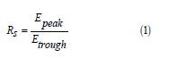
where Epeak and Etrough represent the maximum and minimum seasonal effort totals, respectively. Values of Rs approaching 1.0 indicate minimal seasonality, while higher values indicate pronounced seasonal fluctuation.
Cross-country seasonal relationships were assessed using Pearson correlation coefficients calculated on monthly effort time series (n = 24 months per country pair). This analysis tested whether countries exhibited synchronous (positive correlation), asynchronous (negative correlation), or independent (zero correlation) seasonal patterns.
Spatial Concentration Analysis
The Gini coefficient quantified inequality in the spatial distribution of fishing effort within each EEZ:

where xi represents cumulative fishing hours in grid cell i over the 24-month study period, n is the number of active grid cells (cells with >0 fishing hours), and x is the mean fishing hours per active cell. Gini coefficients range from 0 (perfect equality, all cells with identical effort) to 1 (maximum inequality, all effort in a single cell). Values exceeding 0.6 are generally interpreted as indicating high concentration.
Additionally, the proportion of total effort concentrated in the top decile of active grid cells was calculated as a more intuitive concentration metric.
Hotspot Identification and Persistence
Fishing hotspots were identified as grid cells in the top decile of cumulative effort for each EEZ. Hotspot locations were characterized by latitude/longitude coordinates and mapped to known geographical features (bays, straits, shelf edges).
Inter-annual hotspot persistence was assessed using the Jaccard similarity index:
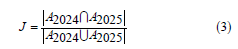
where A2024 and A2025 represent the sets of top-decile grid cells (by annual fishing hours) in 2024 and 2025, respectively. Jaccard indices range from 0 (no overlap, complete turnover of hotspot locations) to 1 (perfect overlap, identical hotspot sets between years).
Inter-Annual Change Analysis
Year-over-year changes in fishing effort were calculated as:
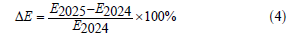
Changes were assessed at national, seasonal, and monthly levels to identify patterns of increase, decrease, or stability.
Comparative Intensity Analysis
Mean fishing intensity (hours per vessel-ID per record) was calculated as a measure of effort concentration per participating vessel. Differences among countries were tested using the Kruskal-Wallis H-test, a non-parametric rank-based alternative to one-way ANOVA appropriate for non-normally distributed data with unequal variances:
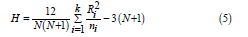
where N is total sample size, k is number of groups (countries), ni is sample size for group i , and Ri is sum of ranks for group i .
Hypothesis Framework
The following a priori hypotheses were formulated based on
literature review and regional fisheries knowledge:
H1: Turkey and Greece will together account for >75% of total
Eastern Mediterranean fishing effort, reflecting their historical
dominance in Mediterranean fisheries production [1,11].
H2: Fishing effort will exhibit significant seasonal variation,
with peaks corresponding to target species avail- ability and
regulatory frameworks.
H3: Fishing effort will be spatially concentrated in productive
zones (shelf edges, coastal embayment’s), yielding Gini coefficients
>0.5 for all countries.
H4: Mean fishing intensity (hours/vessel) will differ
significantly among countries, reflecting fleet composition
differences (industrial vs. artisanal).
H5: Fishing hotspots will persist inter-annually (Jaccard
indices >0.5), reflecting stable environmental productivity
patterns and established fishing practices.
H6: Turkey and Greece will exhibit inverse seasonal patterns
(negative correlation), with fleets alternating be- tween shared
fishing grounds.
Software and Reproducibility
All data extraction, processing, and analysis were performed
using Python 3.11 within a virtual environment to ensure
dependency isolation. Key libraries included:
a) requests (v2.31): HTTP client for GFW API calls
b) pandas (v2.0): Data manipulation and aggregation
c) numpy (v1.24): Numerical computations
d) scipy (v1.11): Statistical tests (Kruskal-Wallis)
e) matplotlib (v3.7): Data visualization
The manuscript was prepared using LATEX with the natbib package for citation management. Analysis scripts and data files are available from the corresponding author upon reasonable request.
Results
Data Summary
A total of 46,078 records were extracted from the GFW database, representing fishing effort across eight Eastern Mediterranean EEZs for the 24-month study period (January 2024–December 2025). Each record corresponds to a unique combination of date (year-month), geographic grid cell (0.1° resolution), and vessel flag state. All countries except Lebanon provided complete 24-month data coverage; Lebanon data showed 23 months with limited activity (Table 2).
The dataset revealed substantial heterogeneity in record density among countries. Greece generated the highest number of records (21,455), reflecting both extensive coastline and broad spatial distribution of fishing activity. Turkey, despite contributing the highest total effort, produced fewer records (14,774) with higher mean effort per record (48.6 hours), suggesting more concentrated fishing patterns. At the opposite extreme, Lebanon contributed only 106 records with minimal effort (690 hours total), consistent with the country’s limited fishing fleet capacity and ongoing socioeconomic constraints.
The mean effort per record varied considerably among countries, ranging from 6.5 hours (Lebanon) to 59.9 hours (Syria). Syria’s exceptionally high value reflects the sparse spatial distribution of its fishing activity, with effort concentrated in a limited number of grid cells. Conversely, Lebanon’s low value indicates both minimal total effort and dispersed activity across the few active cells.
Regional Distribution of Fishing Effort
Turkey and Greece dominated regional fishing effort, together accounting for 1,335,774 hours (86.2%) of the total 1,548,905 hours recorded across all eight EEZs. Turkey alone contributed 46.4% of total effort (718,221 hours), followed by Greece (39.9%; 617,553 hours), Libya (5.1%; 78,809 hours), Cyprus (4.2%; 64,487 hours), Egypt (2.7%; 41,456 hours), Israel (1.1%; 17,034 hours), Syria (0.7%; 10,655 hours), and Lebanon (0.04%; 690 hours).
The distribution exhibited extreme inequality, with the top two countries accounting for more than six times the combined effort of the remaining six nations. This concentration ratio (CR2 = 86.2%) exceeds typical market concentration thresholds in economic analysis, indicating a quasi-duopolistic structure in regional fishing activity. The Herfindahl-Hirschman Index (HHI) for country-level effort distribution was 3,755, far exceeding the 2,500 threshold that indicates high concentration.
To contextualize these proportions relative to coastline length, we calculated effort density (hours per kilometer of coastline). Turkey (1,970 km Mediterranean coastline) exhibited 364.6 hours/km, while Greece (approximately 15,000 km including islands) showed 41.2 hours/km. This ten-fold difference in effort density reflects the fundamentally different fleet structures: Turkey’s concentrated industrial and semi-industrial fleet versus Greece’s dispersed small-scale coastal fleet operating from numerous island ports (Table 3).
Effort intensity per unit EEZ area revealed a different ranking: Turkey exhibited by far the highest intensity (10,117 hours per 1,000 km2), followed by Libya (1,251), Greece (1,221), Syria (1,045), Cyprus (658), Israel (655), Egypt (227), and Lebanon (35). Turkey’s intensity was 8.1 times higher than Greece’s despite similar total effort, reflecting the substantially smaller Turkish EEZ in the Mediterranean. Libya’s elevated intensity, third highest among all countries, is notable given the country’s ongoing civil conflict and suggests concentrated fishing activity in specific productive zones.
The extreme concentration of regional fishing effort is visualized in Figure 1, which illustrates the dominance of Turkey and Greece in the Eastern Mediterranean fishing sector.
Seasonal Patterns
Seasonal patterns in fishing effort varied substantially among countries, with peak-to-trough ratios (Rs) ranging from 1.47 (Greece) to 11.24 (Syria) (Table 4). This variation reflects differences in target species availability, regulatory frameworks, environmental conditions, and fleet operational characteristics.
Turkey
Turkish EEZ fishing effort exhibited pronounced seasonality with autumn peaks and summer troughs. Total autumn effort (318,794 hours) exceeded summer effort (75,894 hours) by a factor of 4.20. Within autumn, October consistently represented the peak month in both years: 57,833 hours (October 2024) and 57,461 hours (October 2025). The summer minimum occurred in May 2024 (8,328 hours), with July and August also showing depressed activity (June–August 2024 mean: 12,056 hours/ month).
Monthly effort exhibited a bimodal annual pattern, with a primary autumn peak (September–November) and a secondary winter peak (December–February). The winter peak (204,089 hours cumulative) was intermediate between summer trough and autumn maximum. Spring showed transitional effort levels, with March maintaining elevated effort before declining through April–May.
This seasonal pattern aligns with known biological cycles of key Turkish target species. Autumn peaks coincide with postspawning aggregations of anchovy (Engraulis encrasicolus) in the Black Sea approaches and seasonal availability of demersal species on the Aegean shelf. The summer trough reflects both reduced target species availability and regulatory closures (Figure 2).


Greece
Greek EEZ displayed the most temporally stable fishing effort among all countries, with a seasonality ratio of only 1.47. While autumn remained the peak season (180,488 hours), the difference from the trough season (summer: 122,461 hours) was proportionally modest. This stability reflects the diversified nature of Greek fisheries, with multiple target species available year-round across the extensive Aegean and Ionian coastlines.
Monthly analysis revealed consistent effort levels of 20,000– 30,000 hours throughout most of the year, with modest peaks in October and November. The summer reduction was less pronounced than in Turkey, suggesting that small-scale coastal fleets - which dominate Greek fisheries - maintain more consistent year-round operations than industrial fleets.
Libya: Anomalous Summer Peak
Libya exhibited a distinctive seasonal pattern fundamentally different from EU Mediterranean countries. Summer represented the peak season (41,308 hours), with winter the trough (4,809 hours), yielding a seasonality ratio of 8.59. This pattern is inverted relative to Turkey and Greece, where summer represents minimal effort.
The Libyan summer peak intensified between years: summer 2024 totaled 17,046 hours, while summer 2025 reached 24,261 hours—a 42.3% inter-annual increase. Spring effort showed an even more dramatic increase, from 4,588 hours (spring 2024) to 11,663 hours (spring 2025), representing a 154.2% rise.
This seasonal pattern likely reflects Libya’s non-EU regulatory status. EU Mediterranean trawl fisheries operate under summer closures (Council Regulation 1967/2006), typically June– September for demersal trawlers. Libyan vessels, not subject to these restrictions, may exploit summer fishing opportunities when EU fleets are inactive. Additionally, calmer summer sea conditions facilitate small-scale artisanal operations that dominate the Libyan fleet.
Egypt
Egyptian EEZ fishing effort peaked in summer (14,507 hours) and reached minimum in winter (6,654 hours), with a seasonality ratio of 2.18. This pattern resembles Libya more than EU countries, consistent with Egypt’s non-EU regulatory framework.
Geographic analysis revealed that Egyptian effort was distributed between Mediterranean and Red Sea waters (the GFW dataset includes all Egyptian maritime zones). The summer peak likely reflects favorable conditions for Red Sea fisheries and reduced storm activity affecting Mediterranean operations.
Small Eastern Mediterranean States
Israel, Syria, and Lebanon exhibited distinct seasonal
signatures:
Israel showed the lowest seasonality among non-EU countries
(Rs = 1.91), with spring peak (5,285 hours) and summer trough
(2,765 hours). This counter-seasonal pattern (peak in spring
rather than autumn) distinguishes Israel from all other countries
in the dataset.
Syria displayed extreme seasonality (Rs = 11.24), with a pronounced spring peak (7,087 hours) dominated by a single month: May 2025 alone contributed 5,058 hours (71.4% of annual spring total). This spike—the highest monthly total in Syrian waters during the study period—warrants further investigation and may reflect either a genuine fishing event or potential data anomalies.
Lebanon showed minimal absolute effort across all seasons (total: 690 hours), with autumn representing the relative peak (338 hours). The extremely low effort levels preclude meaningful seasonal pattern interpretation.
The contrasting seasonal patterns among countries are visualized in Figure 3, highlighting the autumn dominance for Turkey and Greece versus summer peaks for Libya and Egypt.
Cross-Country Correlation Analysis
Monthly fishing effort series were correlated across all country pairs to identify synchronous or asynchronous patterns (Table 5).
Several patterns emerged from the correlation matrix:
a) Turkey–Greece positive correlation (r = 0.42):
Both countries exhibit autumn peaks, though the correlation
is moderate rather than strong, reflecting different seasonality
magnitudes.
b) Libya inverse correlation with Turkey (r = −0.34):
Libya’s summer peak occurs when Turkish effort is minimal,
suggesting potential complementary patterns or regulatory
arbitrage.
c) Non-EU country cluster: Libya, Cyprus, Egypt, and
Syria showed positive inter-correlations (range: 0.35– 0.51),
suggesting shared environmental drivers or similar regulatory
contexts affecting seasonal patterns.
d) Israel independence: Israel showed near-zero
correlations with all countries except weak positive association
with Lebanon (r = 0.13), suggesting unique drivers of Israeli
fishing seasonality.
Spatial Concentration
Analysis of grid-level fishing effort revealed extreme spatial concentration across all Eastern Mediterranean EEZs, with Gini coefficients ranging from 0.777 (Lebanon) to 0.869 (Greece and Egypt) (Table 6). These values substantially exceed those reported for terrestrial economic activities and indicate that fishing effort is concentrated in a small proportion of available fishing grounds.
The concentration metric reveals that approximately threequarters of all fishing effort occurs in just 10% of active grid cells. This pattern is consistent across countries despite vastly different total effort levels, suggesting a fundamental characteristic of fishing behavior rather than country-specific factors (Figure 4).


Turkey: Marmara and I˙skenderun Hotspots
Turkish fishing effort concentrated in two primary regions:
the Sea of Marmara approaches and I˙skenderun Bay. The five
highest-effort grid cells were:
a) 41.1°N, 29.1°E (Marmara entrance): 15,480 hours
b) 41.2°N, 29.1°E (Marmara entrance): 15,213 hours
c) 36.6°N, 36.0°E (I˙skenderun Bay): 12,238 hours
d) 36.7°N, 36.1°E (I˙skenderun Bay): 12,123 hours
e) 41.0°N, 29.0°E (Marmara entrance): 10,982 hours
The Marmara cluster (41.0–41.2°N, 29.0–29.1°E) accumulated 41,675 hours over the study period, representing 5.8% of total Turkish effort in just three grid cells. This concentration reflects the strategic importance of the Bosphorus approaches for both migratory species (anchovy, bonito) and resident demersal stocks. The ˙Iskenderun Bay cluster (36.6–36.8°N, 36.0–36.2°E) accumulated 24,361 hours (3.4%), consistent with previous identification of this area as a major fishing ground for the eastern Turkish fleet [21].
Greece: Thermaikos Gulf Dominance
Greek fishing effort showed the highest spatial concentration
(Gini = 0.869), with the Thermaikos Gulf emerging as the dominant
hotspot:
a) 40.3°N, 22.7°E (Thermaikos Gulf): 17,028 hours
b) 40.2°N, 22.7°E (Thermaikos Gulf): 11,950 hours
c) 40.3°N, 22.8°E (Thermaikos Gulf): 9,255 hours
d) 40.4°N, 22.8°E (Thermaikos Gulf): 7,390 hours
e) 40.8°N, 25.9°E (Thracian Sea): 6,677 hours
The Thermaikos Gulf cluster (40.2–40.4°N, 22.7–22.8°E) contributed 45,623 hours (7.4% of Greek total). This finding aligns precisely with ecosystem modelling by Dimarchopoulou et al. [18], who reported that 48% of Aegean trawling occurs in the Thermaikos Gulf and adjacent Thracian Sea. Our spatial analysis corroborates their conclusion using an independent AIS-based methodology.
Libya: Concentration Despite Conflict
Despite ongoing civil conflict, Libyan fishing effort exhibited
clear spatial structure with concentration along the Gulf of Sidra
and Tripolitanian coast:
a) 33.8°N, 15.3°E (western Tripolitania): 5,976 hours
b) 33.8°N, 15.2°E (western Tripolitania): 5,486 hours
c) 33.8°N, 15.4°E (western Tripolitania): 4,172 hours
d) 33.8°N, 15.1°E (western Tripolitania): 3,597 hours
e) 33.0°N, 14.8°E (Gulf of Sidra): 3,543 hours
The western Tripolitania cluster (33.8°N, 15.1–15.4°E) accumulated 19,231 hours (24.4% of Libyan total) in four adjacent cells, indicating highly localized fishing activity. This concentration may reflect both the presence of productive fishing grounds and proximity to functioning port infrastructure in areas less affected by conflict.
Cyprus: Dual Concentration Pattern
Cypriot fishing effort showed a bimodal spatial distribution,
with hotspots in both northern waters (36.1°N, 34.6– 34.8°E) and
southern coastal zones (34.5–34.7°N, 33.0–33.5°E):
a) 36.1°N, 34.6°E (northern Cyprus): 4,505 hours
b) 36.1°N, 34.8°E (northern Cyprus): 4,251 hours
c) 36.1°N, 34.7°E (northern Cyprus): 4,124 hours
d) 34.7°N, 33.0°E (southern Cyprus): 3,753 hours
e) 34.5°N, 33.5°E (southern Cyprus): 3,236 hours
The northern cluster contributed 12,880 hours (20.0% of Cypriot total), consistent with known fishing grounds along the Karpaz Peninsula. The southern cluster (6,989 hours; 10.8%) reflects Republic of Cyprus fleet operations from Limassol and Larnaca ports. This dual pattern is notable given the divided island’s complex fisheries governance structure [14].
The spatial distribution of fishing effort across the entire study region is visualized in Figure 5, revealing the concentration of activity in the Aegean Sea, Turkish coastal waters, and specific North African hotspots.
Egypt: Red Sea vs. Mediterranean Distribution
The GFW API returns fishing effort data for all Egyptian
maritime zones, including Red Sea waters. While this study focuses
on the Eastern Mediterranean, we report Egyptian hotspots
across both basins for completeness. Egyptian hotspots revealed
a complex geographic pattern spanning both Mediterranean and
Red Sea waters:
24.9°N, 35.9°E (Red Sea): 3,896 hours
24.2°N, 35.7°E (Red Sea): 1,685 hours
31.5°N, 32.3°E (Mediterranean, Port Said): 1,498 hours
31.3°N, 30.1°E (Mediterranean, Alexandria): 1,381 hours
27.8°N, 33.9°E (Red Sea): 1,347 hours
Remarkably, three of the five highest-effort Egyptian grid cells were located in the Red Sea (24–28°N) rather than the Mediterranean. Red Sea cells contributed 6,928 hours, while Mediterranean cells contributed 2,879 hours among the top five. This finding indicates that Egyptian AIS-tracked fishing activity is substantially concentrated in Red Sea waters, possibly reflecting different fleet compositions and target fisheries between the two maritime zones.
Inter-Annual Variation
Total regional fishing effort increased by 6.6% from 2024 (757,204 hours) to 2025 (791,702 hours). However, this aggregate trend masked substantial heterogeneity among countries, with inter-annual changes ranging from −8.7% (Greece) to +469.0% (Syria) (Table 7).
Syria: Anomalous Increase
The +469% increase in Syrian fishing effort warrants detailed
examination. Monthly data revealed that this increase was not
gradual but concentrated in specific months:
a) May 2025: 5,058 hours (single-month maximum across
entire Syrian dataset)
b) March 2025: 981 hours (versus 5 hours in March 2024)
c) June 2025: 1,170 hours (versus 267 hours in June 2024)
The May 2025 spike alone contributed 55.8% of total 2025
Syrian effort. This concentrated pattern could reflect:
a) genuine increase in Syrian fishing fleet activity
b) improved AIS transponder adoption
c) vessels previously unreported entering the dataset
d) potential data quality issues.
The temporal concentration in spring 2025 coincides with known Syrian fleet patterns targeting seasonal species aggregations, but the magnitude of increase exceeds plausible biological or fleet capacity explanations.
Libya: Sustained Growth
Libyan effort increased by 60.0%, from 30,306 hours (2024)
to 48,503 hours (2025). Unlike Syria, this increase was distributed
across multiple seasons:
a) Summer: +42.3% (17,046 24,261 hours)
b) Spring: +154.2% (4,588 11,663 hours)
c) Autumn: +23.2% (7,367 9,074 hours)
d) Winter: +168.5% (1,305 3,504 hours)
The broad-based increase suggests genuine fleet expansion or improved monitoring coverage rather than a single anomalous event. This growth occurred despite continued civil conflict, potentially reflecting recovery of fishing operations in areas achieving relative stability.
The heterogeneous inter-annual changes across countries are visualized in Figure 6, illustrating the contrast be- tween dramatic increases in Syria and Libya versus decline in Greece.
Greece: Declining Effort
Greece was the only major fishing nation showing decreased
effort (−8.7%). Monthly analysis revealed that the decline was
concentrated in winter and spring 2025:
a) January 2025: 20,721 hours (versus 24,141 hours in
January 2024)
b) February 2025: 19,254 hours (versus 22,487 hours in
February 2024)
c) March 2025: 21,412 hours (versus 25,553 hours in
March 2024)
This pattern may reflect fuel cost increases affecting smallscale fleet operations, regulatory constraints, or stock declines affecting fishing viability. However, autumn effort remained relatively stable between years (180,488 hours combined), suggesting that core fishing operations during peak season were maintained.
Hotspot Persistence
The Jaccard similarity index quantified inter-annual stability of high-effort grid cells. For each country, top-decile cells (by effort) were identified separately for 2024 and 2025, and the intersection divided by union calculated (Table 8).
Jaccard indices ranged from 0.40 (Lebanon) to 0.73 (Turkey), indicating that 40–73% of top-effort grid cells were shared between years. Turkey exhibited the highest persistence, consistent with stable industrial fishing patterns around established grounds (Marmara, ˙Iskenderun). Egypt showed intermediate persistence (0.58), potentially reflecting variable Red Sea fishing patterns or shifting Mediterranean effort distribution. Syria and Lebanon showed lower persistence (0.44 and 0.40, respectively), likely reflecting their limited overall fishing activity and small number of active grid cells.
This temporal stability supports Hypothesis H5 and has practical implications: persistent hotspots can serve as priority monitoring zones for fisheries enforcement and as focus areas for ecosystem-based spatial management.
Fishing Intensity Comparison
Mean fishing intensity (hours per vessel-ID per record) differed significantly among countries (Kruskal-Wallis H = 1,847.3, p < 0.001, η2 = 0.040). Although statistically significant, the effect size indicates that country explains approximately 4% of variance in fishing intensity, with the remainder attributable to within-country vessel heterogeneity. Dunn’s post-hoc tests with Bonferroni correction revealed significant pairwise differences between Syria and all other countries except Turkey (p < 0.01), and between Turkey-Greece, Turkey-Egypt, and Turkey- Lebanon pairs (p < 0.05). Intensity metrics provide insight into fleet operational characteristics independent of total effort volumes (Table 9).
Syria exhibited the highest mean intensity (59.9 hours/ record) but also highest variability (SD = 156.9), reflecting the sparse, concentrated nature of Syrian fishing effort. Turkey showed second-highest intensity (48.6 hours/record) with substantial variability, consistent with mixed industrial and semiindustrial fleet composition
The intensity ranking (Syria > Turkey > Israel > Greece > Libya > Cyprus > Egypt > Lebanon) broadly correlates with vessel size and gear type: higher intensities are associated with larger vessels capable of extended fishing trips, while lower intensities reflect small-scale artisanal operations with shorter trips and more frequent port calls.
Summary of Hypothesis Tests
Table 10 summarizes the status of each a priori hypothesis based on the results presented.
Discussion
Regional Dominance Patterns
The finding that Turkey and Greece together account for 86.2% of Eastern Mediterranean fishing effort aligns with historical patterns documented in earlier studies. Relini [1] reported that Turkey held 26.9% and Greece 9% of total Mediterranean and Black Sea fishery production in 2000. Our results suggest that this regional dominance has intensified, with these two nations now controlling an even larger share of fishing activity in the Eastern Mediterranean basin specifically.
These findings are corroborated by recent basin-wide analyses using complementary remote sensing approaches. Marsaglia et al. [6] combined Synthetic Aperture Radar (SAR) vessel detections with AIS data to estimate trawl fishing activity across the entire Mediterranean Sea, reporting that the Aegean Sea (GSA 22, encompassing Greek and Turkish waters) accounts for 11% of total predicted Mediterranean trawl activity. Their analysis also revealed that the North Levant region (GSA 24, southern Turkey) represents 4% of Mediterranean-wide trawl effort, while the South Levant (GSA 26, Egypt) accounts for 7%. The SAR-based predictions demonstrated that fishing grounds along the Egyptian and Tunisian coasts exhibit intensity levels comparable to the Adriatic Sea— historically documented as one of the most heavily trawled regions globally [6].
The Greek fishing sector is characterized by a substantial fleet operating in the Aegean and Ionian Seas. Keramidas et al. [8] estimated approximately 15,154 professional small-scale coastal vessels in Greek waters (GSA 20 and 22 combined), in addition to over 31,000 recreational fishing vessels. This extensive fleet infrastructure supports the high fishing effort observed in our analysis of the Greek EEZ. Roditi and Vafidis [9], Roditi et al. [10] identified Kalymnos Island as hosting the largest smallscale coastal fleet in the Eastern Mediterranean, with 21 distinct métiers documented across net and longline fisheries, and seasonal patterns driven by target species avail- ability. The multispecies nature of these fisheries, targeting Pagrus pagrus, Diplodus vulgaris, Pagellus erythrinus, and Xiphias gladius, reflects the characteristic complexity of Mediterranean small-scale fisheries.
Turkey’s dominance in regional fishing effort reflects its historical position as the leading fishing nation in the Eastern Mediterranean and Black Sea basins. Ulman et al. [11] documented that approximately 75% of Turkey’s marine landings originate from the Black Sea coast, with additional contributions from the Aegean (FAO 37.3.1) and Levantine (FAO 37.3.2) sub-areas. The substantial underreporting identified in Turkish fisheries— with actual catches estimated at 63% above official statistics— suggests that AIS-based fishing effort data, as used in the present study, may provide a more accurate representation of true fishing pressure than traditional landing statistics. The high fishing effort documented in the Turkish EEZ is concerning given that Turkish national catches peaked in 1988 and have been declining since, with both the quality and quantity of fisheries catches in critical condition [12].
The issue of unreported catches is pervasive throughout the Mediterranean basin. Coll et al. [23] estimated that illegal, unreported, and unregulated (IUU) fishing accounted for an average of 43% of total fisheries removals in the Spanish Mediterranean over 1950–2010, with similar or higher proportions documented for Greece (35%) and Turkey (63%). Similarly, Ulman et al. [14] demonstrated that Cyprus’s actual marine fisheries catches were 2.6 times higher than officially reported data, with unreported commercial landings, recreational catches, and discards contributing substantially to total removals. Edelist et al. [15] documented comparable underreporting for Israel, with reconstructed catches 28.9% higher than FAO-reported landings, driven primarily by trawl discards (estimated at 47% of catch by 2008–2011) and an unregulated recreational sector accounting for 20% of total removals by 2010. Ulman et al. [24] found even greater discrepancies for Syria, with reconstructed catches 78% higher than FAO-reported data, attributed to unmonitored artisanal landings bypassing official market channels. These findings highlight the value of vessel monitoring systems and AIS-derived effort metrics as complementary tools for assessing fishing pressure in data-limited contexts.
Ecosystem Implications
The spatial concentration of fishing effort documented in this study aligns with ecosystem modelling findings from the Aegean Sea. Keramidas et al. [17] demonstrated that small-scale coastal fisheries exert the strongest negative impact on ecosystem functional groups through both direct targeting and incidental catch. Our results corroborate this pattern, with fishing effort hotspots concentrated in coastal and shelf waters where artisanal and demersal fleets predominantly operate. The dominance of Turkish and Greek fishing effort (86.2%) within the Eastern Mediterranean EEZs has direct implications for regional fisheries governance under the GFCM framework [2].
The concentration of fishing effort in specific productive areas, such as the Thermaikos Gulf which alone produces over 20% of total Greek catches, illustrates the ecological significance of spatial management. Ecosystem simulations for this area by Dimarchopoulou et al. [18] revealed that fishing effort reduction scenarios resulted in higher biomass across functional groups, with catches initially increasing after effort reduction before stabilizing at levels closer to sustainable yields. Their finding that 48% of Aegean trawling occurs in the Thermaikos Gulf and adjacent Thracian Sea illustrates the extreme spatial concentration that our Gini coefficient analysis confirms at the regional scale.
Seasonal Dynamics
The pronounced autumn fishing peak observed in Turkish EEZ (320% higher than summer; Rs = 4.20) reflects multiple interacting factors. The Mediterranean’s marked seasonality, with important vertical convections in winter recycling nutrients from depth [1], creates conditions favorable for productivity peaks in autumn. Additionally, fishing closures during summer months for certain species in Turkish waters may contribute to effort concentration in autumn.
These seasonal patterns exhibit similarities and differences compared to other Mediterranean fleet analyses. Pulcinella et al. [5] documented that deepwater red shrimp trawlers in the eastern–central Mediterranean (GSAs 12–27) exhibited marked seasonality with activity peaks during spring and summer quarters, contrasting with the autumn peak observed in our study for Turkish and Greek coastal fisheries. This divergence likely reflects differences in target species: deepwater shrimp fisheries follow the biological cycles of Aristaeomorpha foliacea and Aristeus antennatus, whereas coastal demersal fisheries target assemblages of sparids, mullets, and cephalopods with different seasonal availability patterns. The positive correlation between Turkish and Greek monthly fishing effort (r = 0.42, p = 0.041, n = 24 months) was statistically significant but contrary to our hypothesis of inverse seasonal patterns. This synchronization suggests that both fleets respond similarly to basin-wide environmental and biological drivers rather than exhibiting compensatory patterns.
Libya: Inverted Seasonality and Regulatory Arbitrage
The Libyan summer peak (Rs = 8.59) represents a notable departure from EU Mediterranean patterns and warrants careful interpretation. While Turkey and Greece show pronounced summer troughs—consistent with EU trawl closures under Council Regulation 1967/2006 (typically June–September for demersal trawlers)—Libyan effort reaches its maximum during precisely this period. This inversion suggests potential regulatory arbitrage: non-EU fleets may exploit fishing opportunities when EU competitors face operational restrictions.
Several factors could explain this pattern beyond regulatory asymmetry. First, calmer summer sea conditions along the Libyan coast facilitate small-scale artisanal operations that dominate the Libyan fleet, which has experienced severe capacity decline from approximately 200 vessels to 67 vessels between 2015 and 2019 [16]. Second, the summer peak may reflect target species biology unique to southern Mediterranean waters, including spawning aggregations of groupers and seasonal availability of small pelagics. Third, the inter-annual intensification of the summer peak (42.3% increase from 2024 to 2025) suggests either genuine fleet recovery or improved AIS coverage as conflict-affected areas stabilize.
The policy implications are significant: if Libyan summer effort represents substitution for EU fleet activity during closure periods, then GFCM-level coordination may be necessary to prevent management measures in some juris- dictions from simply displacing effort to unregulated or differently-regulated waters. This finding echoes broader concerns about asymmetric regulation creating competitive advantages for non-EU Mediterranean fleets [2].
Syria: Anomalous Effort Spike
The 469% increase in Syrian fishing effort between 2024 and
2025 presents an analytical challenge. The May 2025 spike (5,058
hours—exceeding the entire 2024 Syrian total) demands critical
evaluation. Several hypotheses may explain this pattern:
Hypothesis 1: Genuine fleet activity. Syrian waters host
productive fishing grounds, and the spring timing coincides with
known seasonal aggregations. However, the magnitude of increase
exceeds plausible fleet capacity expansion given Syria’s ongoing
conflict and economic constraints.
Hypothesis 2: Improved AIS coverage. The spike may reflect
vessels newly equipped with AIS transponders or vessels that
previously disabled transponders now broadcasting consistently.
This interpretation aligns with observations of gradually
improving maritime monitoring in conflict-affected regions.
Hypothesis 3: Transient foreign vessels. The concentrated
temporal pattern (primarily May 2025) is consistent with
seasonal incursions by foreign fleets operating in Syrian waters.
Turkish and Lebanese vessels have historically operated in Syrian
EEZ under various arrangements, and improved AIS detection
might capture previously unobserved activity.
Hypothesis 4: Data anomaly. While GFW data undergo quality
control, the extreme concentration (one month accounting for
56% of annual effort) warrants caution. Potential sources include
misattribution of vessel positions, flag state errors, or algorithmic
artifacts.
We cannot definitively distinguish among these hypotheses with available data. However, the persistence of elevated Syrian effort in subsequent months (June–August 2025) argues against a pure data anomaly interpretation. Future research should examine vessel-level AIS tracks in Syrian waters to characterize the composition and behavior of vessels contributing to this increase.
Cross-Country Seasonal Coordination
The correlation analysis revealed previously undocumented patterns of seasonal coordination among Eastern Mediterranean fishing nations. The positive Turkey–Greece correlation (r = 0.42) indicates synchronized seasonal response, while the negative Turkey–Libya correlation (r = -0.34) suggests complementary patterns potentially exploitable for regional burden-sharing in management.
The cluster of positive correlations among Libya, Cyprus, Egypt, and Syria (range: 0.35–0.51) may reflect shared environmental drivers affecting southern and eastern Mediterranean waters differently from northern Aegean pat- terns. Alternatively, this clustering may reflect similar regulatory contexts (non-EU countries not subject to common summer closures), suggesting that regulatory frameworks may be a stronger determinant of seasonal patterns than environmental factors.
Israel’s near-zero correlations with all countries represents an outlier pattern that may reflect the unique characteristics of Israeli fisheries—small EEZ, limited fleet, and distinct target species assemblage dominated by neritic species and recreational fishing [15].
Spatial Concentration and Hotspots
The Gini coefficients for spatial distribution of fishing effort ranged from 0.777 (Lebanon) to 0.869 (Greece and Egypt), indicating extreme inequality in the spatial allocation of fishing activity across all Eastern Mediterranean EEZs. These values substantially exceed Gini coefficients typically observed in spatial economic analyses and indicate that approximately 75–82% of all fishing effort concentrates in just 10% of active grid cells. This concentration aligns with established theory that fishing vessels target specific productive areas associated with topographic features, nutrient upwelling zones, or aggregation sites for target species.
The spatial concentration documented here is consistent with broader Mediterranean patterns. Marsaglia et al. [6] reported that just 15 of 30 GSAs (Geographical Sub-Areas) account for more than 70% of predicted trawl fishing activity basin-wide, with particular concentration in the Northern Adriatic (GSA 17), Aegean Sea (GSA 22), and coastal Tunisia (GSAs 12–14). Our cell-level analysis extends this finding to demonstrate that concentration occurs not just among GSAs but also within them—even highly active GSAs show extreme internal spatial heterogeneity.
Hotspot Validation Against Independent Studies
The identification of Thermaikos Gulf (40.2–40.4°N, 22.7–22.8°E) as the dominant Greek fishing hotspot provides independent validation of ecosystem modelling findings by Dimarchopoulou et al. [18], who reported that 48% of Aegean trawling occurs in this region. Our data show the Thermaikos cluster contributing 45,623 hours (7.4% of Greek total), consistent with their ecosystem-model-derived estimates. This convergence between AIS-derived effort metrics and ecological model outputs strengthens confidence in both methodological approaches.
Similarly, the identification of ˙Iskenderun Bay (36.6– 36.8°N, 36.0–36.2°E) as a Turkish hotspot corroborates recent hidden fishing hotspot analysis by Coro et al. [21], who used 1.6 billion AIS records (2017–2022) to identify the Gulf of Alexandretta (˙Iskenderun) as a persistent high-activity zone. Their methodology distinguished between AIS signal loss due to communication issues and intentional transponder switchoffs, concluding that Mediterranean hidden fishing hotspots often correspond to potential IUU fishing. The persistence of ˙Iskenderun as a hotspot across multiple independent studies spanning 2017–2025 suggests stable, long-term fishing patterns in this region—patterns that warrant management attention given the overlap with important spawning and nursery habitats.
Ecological Interpretation of Spatial Patterns
The extreme spatial concentration (Gini > 0.8 in most countries) has important ecological implications. High fishing pressure concentrated in limited areas may create localized depletion effects not captured by aggregate effort statistics. Target species experiencing intensive exploitation in hotspot zones may exhibit truncated size distributions, altered age structures, and potentially evolutionary responses to fishing pressure.
The consistency of hotspot locations between years (Jaccard indices 0.40–0.73) further amplifies these concerns: persistent exploitation of the same areas year after year may exceed local carrying capacity even when regional aggregate effort appears sustainable. This argues for spatially-explicit stock assessment approaches that account for the documented heterogeneity in fishing pressure distribution.
The spatial patterns we observed are also consistent with AIS-based fleet mobility analyses by Armelloni et al. [22], who demonstrated that Mediterranean trawl fleets exhibit limited operational ranges, with vessels typically operating within 50– 100 km of home ports and consistently returning to preferred fishing grounds. This home- range fidelity contributes to hotspot persistence and suggests that management interventions in specific locations could effectively protect substantial proportions of vulnerable stocks.
Inter-Annual Stability and Dynamics
The Jaccard similarity indices (0.40–0.73) between 2024 and 2025 hotspots indicate spatial stability in fishing ground selection across Eastern Mediterranean fishing nations, though with notable variation. Turkey exhibited the highest persistence (0.73), consistent with stable industrial fishing patterns around established grounds (Marmara, I˙skenderun), while smaller fishing nations showed lower persistence reflecting more limited and variable activity patterns. This stability reflects multiple factors: consistent environmental characteristics of productive zones, established fishing practices transmitted across fishing communities, port infrastructure constraining operational range, and regulatory frameworks that create predictable spatial patterns.
However, stability in hotspot locations coexisted with substantial variability in total effort levels. The 60% increase in Libyan effort and 469% increase in Syrian effort occurred within spatially stable frameworks—the same grid cells received more effort rather than effort spreading to new areas. This pattern suggests that capacity changes (fleet expansion, improved monitoring, or behavioral changes) are superimposed on fundamentally stable spatial preferences.
The divergent inter-annual trends among countries—ranging from −8.7% (Greece) to +469% (Syria)—preclude simple regional interpretations. The Greek decline may reflect economic constraints (fuel costs, market conditions) or management measures affecting the 15,000+ vessel small-scale fleet. The Syrian and Libyan increases may reflect conflict-area stabilization, improved AIS adoption, or genuine fleet expansion. Disentangling these factors requires vessel-level longitudinal analysis beyond the scope of the present aggregate data.
Limitations
Several limitations warrant consideration:
a) AIS coverage: Not all fishing vessels carry AIS
transponders, particularly smaller artisanal vessels.
Approximately 90% of the Mediterranean fishing fleet consists
of small-scale vessels (<12 m) that are not required to carry
VMS or AIS transponders [25]. GFW data therefore represent a
subset of total fishing activity, potentially biased toward larger,
industrial vessels. This limitation is particularly significant for
coastal areas where small-scale fisheries dominate, such as
Cyprus where the artisanal fleet comprises over 1,500 vessels
across both the northern and southern parts of the island [14].
Previous Mediterranean-wide AIS mapping by Ferrà et al. [4]
noted minimal coverage from African waters and southern
Mediterranean states. Furthermore, AIS coverage varies
markedly among Mediterranean countries; Armelloni et al. [22]
demonstrated that while EU fleets achieved approximately 76%
coverage, non-EU countries exhibited substantially lower values
(Turkey: 57%; Israel: 108%) or near-zero coverage (Egypt, Syria,
Algeria). This disparity suggests that our fishing effort estimates
for certain Eastern Mediterranean states may underrepresent
actual activity levels.
The magnitude of this underestimation has been quantified through comparisons between AIS-observed and SAR-detected fishing vessels. Paolo et al. [20] demonstrated that roughly three-quarters of industrial fishing vessels worldwide are not publicly tracked by AIS, with particularly pronounced gaps in the Mediterranean. In the Strait of Sicily between Italy and Tunisia, more than 60% of fishing vessels detected by satellite radar were not broadcasting AIS data [6]. When considering only GSAs along the North African coast (Egypt, Tunisia, Algeria), SARbased estimates revealed systematic underestimation by AIS on the order of 3,000–5,000 fishing hours per year per grid cell [6]. Furthermore, the discrepancy between SAR and AIS estimates was most pronounced in shallower coastal waters, suggesting that smaller trawl vessels operating nearshore—precisely those less likely to carry AIS transponders—account for substantial unobserved fishing activity. These findings indicate that our reported effort values for Egypt, Libya, Syria, and Lebanon likely represent lower bounds of actual fishing pressure in these EEZs. The situation in Libya is further complicated by ongoing conflict, which has severely disrupted fisheries monitoring and enforcement; Abziow [16] documented a 70% decline in operational fishing vessels along the Derna coast between 2015 and 2019, accompanied by widespread blast fishing (896 recorded incidents) that has devastated local fish stocks and habitats.
A comprehensive big data analysis of 1.6 billion AIS records
from Mediterranean trawlers (2017–2022) by Coro et al. [21]
identified persistent hidden fishing hotspots in the Aegean Sea
(Thermaic Gulf, waters off Lesvos and 0˘130zmir), the Gulf of
Alexandretta in southeastern Turkey, and coastal Israel. Their
methodology distinguished between AIS signal loss due to
communication issues and intentional transponder switch-offs,
concluding that most Mediterranean hidden fishing hotspots
correspond to potential illegal, unreported, and unregulated
(IUU) fishing rather than technical failures. Their manifest fishing
distributions achieved 91% agreement with GFW data, validating
the reliability of AIS-based effort estimation approaches such as
those employed in the present study.
b) Aggregated data: The use of aggregated grid-cell
data prevented individual vessel-level analyses. Speed profiles,
route efficiency, and other vessel-specific metrics could not be
calculated.
c) Gear type: Although the GFW algorithm classifies
fishing by gear type, this classification was not available at the
output level requested, precluding gear-specific analyses.
d) Two-year window: The 24-month study period may not
capture longer-term trends or multi-year cycles in fishing effort.
Implications for Fisheries Management
The General Fisheries Commission for the Mediterranean (GFCM) serves as the primary regional fisheries management organization for Mediterranean waters. Despite management frameworks implemented through both GFCM and EU regulations (including Regulation 1967/2006 and the Common Fisheries Policy), stock assessments continue to indicate widespread overexploitation, with more than 90% of assessed stocks exceeding sustainable fishing mortality levels [2].
Ecosystem modelling studies from the region provide evidence that fishing effort reduction can lead to stock recovery. Dimarchopoulou et al. [18] demonstrated through Ecosim simulations that 10–50% reductions in fishing effort resulted in proportionally higher biomass in the Thermaikos Gulf ecosystem, with predatory fish groups showing the most pronounced recovery. Their simulations extending to 2025 showed that while environmental drivers remain significant, fishing effort constitutes a controllable parameter that can be regulated to promote ecosystem resilience.
Our findings of high fishing effort concentration align with observations from Egyptian lagoon fisheries, where declining CPUE trends in Bardawil Lagoon indicate overexploitation of multiple commercial species [13]. The seasonal management approach implemented in Bardawil Lagoon—with winter closure from January to March for spawning protection—represents one example of adaptive management that could inform regional efforts.
The challenge of managing transboundary resources in the Eastern Mediterranean is compounded by asymmetric monitoring capacity among coastal states. While this study documents that Turkey and Greece together account for 86.2% of AIS-observed fishing effort, the SAR-based analyses by Marsaglia et al. [6] suggest that substantial additional fishing activity occurs in waters adjacent to non-EU countries where AIS adoption remains limited. Effective regional management will require harmonization of vessel tracking requirements across all GFCM member states, potentially incorporating emerging technologies such as SAR-based monitoring to complement traditional VMS and AIS systems. The integration of remote sensing data, as demonstrated by recent methodological advances [6,20], offers a promising avenue to overcome monitoring gaps and reduce the information asymmetry that currently constrains evidence-based fisheries management in the Mediterranean.
The quantitative baseline established by this study provides
reference data for monitoring future changes in fishing effort
distribution. The identification of dominant nations, seasonal
patterns, and spatial hotspots can inform:
a) Allocation of monitoring resources
b) Design of seasonal closures
c) Identification of priority areas for ecosystem-based
management
d) Regional cooperation frameworks among coastal states
Conclusion
This study provides a quantitative analysis of fishing effort
distribution across eight Eastern Mediterranean coastal states
using GFW-AIS data from 2024–2025. The principal findings are:
a) Regional dominance: Turkey and Greece together
account for 86.2% of total fishing effort in Eastern Mediterranean
EEZs, confirming continued dominance of these two nations
in regional fisheries. This con- centration exceeds historical
proportions documented in landing statistics, suggesting an
intensification of fishing activity by these dominant nations.
b) Seasonal patterns: Turkish EEZ exhibits pronounced
seasonality with autumn peaks exceeding summer effort by
more than 300% (Rs = 4.20). Greek EEZ shows similar but less
pronounced seasonal variation (Rs= 1.47). These patterns align
with Mediterranean environmental seasonality and may reflect
both biological cycles of target species and regulatory frameworks
governing seasonal closures.
c) Spatial concentration: Fishing effort is highly
concentrated, with the top 10% of grid cells accounting for 65–
83% of total effort across countries (Gini coefficients 0.78–0.87).
Key hotspots include the Marmara Sea entrance, ˙Iskenderun Bay,
and Aegean coastal areas. This spatial concentration aligns with
basin-wide patterns documented through combined AIS-SAR
analyses [6].
d) Temporal stability: Hotspot locations showed
moderate to high persistence between 2024 and 2025 (Jaccard
indices 0.40–0.73), indicating generally consistent spatial
patterns in fishing ground utilization that may facilitate targeted
monitoring and management interventions.
e) Inter-country variation: Significant differences in
fishing intensity exist among coastal states, with Turkey exhibiting
the highest hours-per-vessel metric.
These findings establish a quantitative baseline for monitoring and managing Eastern Mediterranean fisheries. The demonstrated utility of GFW-AIS data for regional-scale analysis supports continued application of satellite-based monitoring tools for fisheries assessment. However, the substantial AIS coverage gaps documented for non-EU Mediterranean states— with SAR-based analyses suggesting that 60% or more of fishing vessels in certain areas do not broadcast AIS [6,20]—indicate that our effort estimates likely represent lower bounds for countries such as Egypt, Libya, Syria, and Lebanon.
Future research should extend the temporal coverage to assess longer-term trends and incorporate gear-type classification to refine understanding of fishing fleet composition. Additionally, integration with biological stock assessment data would enable evaluation of fishing pressure relative to sustainable yield estimates. The development of complementary monitoring approaches, including SAR-based vessel detection, offers promising avenues to ad- dress AIS coverage limitations and provide more complete assessments of fishing activity across the Mediterranean basin.
Acknowledgement
This study utilized data from Global Fishing Watch (GFW) API v3. The author acknowledges GFW for providing open access to fishing effort data.
Data Availability Statement
The fishing effort data used in this study are publicly available through the Global Fishing Watch API (https://globalfishingwatch. org/download/). EEZ boundary data were obtained from Marine Regions (https://www.marineregions.org/). Analysis scripts are available from the corresponding author upon reasonable request.
Use of AI-Assisted Technologies
The author used AI-assisted tools (GitHub Copilot, Claude) for code debugging and language editing during manuscript preparation. The author reviewed, verified, and takes full responsibility for all content, analyses, and conclusions presented in this manuscript.
References
- Relini G (2003) Fishery and aquaculture relationship in the Mediterranean: Present and future. Mediterranean Marine Science 4(2): 125-154.
- Colloca F, Scarcella G, Libralato S (2017) Recent trends and impacts of fisheries exploitation on Mediterranean stocks and ecosystems. Frontiers in Marine Science 4: 244.
- Kroodsma DA, Mayorga J, Hochberg T, Miller NA, Boerder K, et al. (2018) Tracking the global footprint of fisheries. Science 359(6378): 904-908.
- Ferrà C, Tassetti AN, Grati F, Pellini G, Polidori P, et al. (2018) Mapping change in bottom trawling activity in the Mediterranean Sea through AIS data. Marine Policy 94: 275-281.
- Pulcinella J, Armelloni EN, Ferrà C, Scarcella G, Tassetti AN (2023) Deepwater red shrimp fishery in the eastern–central Mediterranean Sea: AIS-observed monthly fishing effort and frequency over 4 years. Earth System Science Data 15: 809-820.
- Marsaglia L, Parisi A, Libralato S, Miller NA, Davis P, et al. (2024) Shedding light on trawl fishing activity in the Mediterranean Sea with remote sensing data. ICES Journal of Marine Science 82(2): fsae153.
- Demirci A (2024) Assessing foreign fishing activities in Türkiye’s contiguous zone: A decade of insights and management implications. Journal of Anatolian Environmental and Animal Sciences 9(3): 449-456.
- Keramidas I, Dimarchopoulou D, Pardalou A, Tsikliras AC (2018) Estimating recreational fishing fleet using satellite data in the Aegean and Ionian Seas (Mediterranean Sea). Fisheries Research 208: 1-6.
- Roditi K, Vafidis D (2019) Net fisheries’ métiers in the Eastern Mediterranean: Insights for small-scale fishery management on Kalymnos Island. Water 11(7): 1509.
- Roditi K, Antoniadou C, Matsiori S, Halkos G, Vafidis D (2020) Longline métiers and associated economic profiles in eastern Mediterranean fisheries: The case study of Kalymnos Island (South Aegean Sea). Ocean and Coastal Management 195: 105275.
- Ulman A, Bekişoğlu Ş, Zengin M, Knudsen S, Ünal V, et al. (2013) From bonito to anchovy: a reconstruction of Turkey’s marine fisheries catches (1950–2010). Mediterranean Marine Science 14(2): 309-342.
- Yildiz T, Ulman A (2020) Analyzing gaps in policy: Evaluation of the effectiveness of minimum landing size (MLS) regulations in Turkey. Marine Policy 115: 103829.
- Mehanna SF, Eid AHM, Ali BA, Abdel-Baky W (2023) Fishing effort, catch per unit fishing effort and relative abundance of the common fish species in Bardawil Lagoon, Egypt. Egyptian Journal of Aquatic Biology and Fisheries 27(5): 587-604.
- Ulman A, Çiçek BA, Salihoglu I, Petrou A, Patsalidou M, et al. (2015a) Unifying the catch data of a divided island: Cyprus’s marine fisheries catches, 1950–2010. Environment, Development and Sustainability 17(4): 801-821.
- Edelist D, Scheinin A, Sonin O, Shapiro J, Salameh P, et al. (2013) Israel: Reconstructed estimates of total fisheries removals in the Mediterranean, 1950–2010. Acta Adriatica 54(2): 253-264.
- Abziow EANAF (2025) Degradation factors on marine fisheries in the coastline of Dernah, east Libya. Libyan Journal of Ecological & Environmental Sciences and Technology 7(1): 12-24.
- Keramidas I, Dimarchopoulou D, Tsikliras AC (2022) Modelling and assessing the ecosystem of the Aegean Sea, a major hub of the eastern Mediterranean at the intersection of Europe and Asia. Regional Studies in Marine Science 56: 102704.
- Dimarchopoulou D, Tsagarakis K, Sylaios G, Tsikliras AC (2022) Ecosystem trophic structure and fishing effort simulations of a major fishing ground in the northeastern Mediterranean Sea (Thermaikos Gulf). Estuarine, Coastal and Shelf Science 264: 107667.
- Global Fishing Watch (2024) Global fishing watch API documentation.
- Paolo FS, Kroodsma D, Raynor J, Hochberg T, Davis P, et al. (2024) Satellite mapping reveals extensive industrial activity at sea. Nature 625: 85-91.
- Coro G, Pavirani L, Ellenbroek A (2024) Extracting Mediterranean hidden fishing hotspots through big data mining. IEEE Access 12: 85465-85483.
- Armelloni EN, Tassetti AN, Ferrà C, Galdelli A, Scanu M, et al. (2021) AIS data, a mine of information on trawling fleet mobility in the Mediterranean Sea. Marine Policy 129: 104571.
- Coll M, Carreras M, Cornax M, Massutí E, Morote E, et al. (2014) Closer to reality: Reconstructing total removals in mixed fisheries from Southern Europe. Fisheries Research 154: 179-194.
- Ulman A, Saad A, Zylich K, Pauly D, Zeller D (2015b) Reconstruction of Syria’s fisheries catches from 1950–2010: Signs of overexploitation. Acta Ichthyologica et Piscatoria 45(3): 259-272.
- Moutopoulos DK, Katselis G, Prodromitis G, Koutsikopoulos C (2020) Mapping fisheries hot-spot and high-violated fishing areas in professional and recreational small-scale fisheries. Aquaculture and Fisheries 5(5): 265-272.


