Analysis of Hail Processes Caused by a Supercell Storm
Li Gao1, Luan Li2, Nan Li3*, Yongjiang Yu4 and Ben Niu5
1Taizhou Meteorological Bureau, China
2Wuhu Meteorological Bureau, China
3 School of Atmospheric Physics, Nanjing University of Information Science and Technology, China
4Fujian Institute of Meteorological Sciences, China
5Wuhan Central Meteorological Observatory, China
Submission:February 20, 2020; Published:March 13, 2020
*Correspondence author: Nan Li, School of Atmospheric Physics, Nanjing University of Information Science and Technology, China
How to cite this article:Li Gao, Luan Li, Nan Li, Yongjiang Yu, Ben Niu. Analysis of Hail Processes Caused by a Supercell Storm. Oceanogr Fish Open Access J. 2020; 11(5): 555823. DOI: 10.19080/OFOAJ.2020.11.555823
Abstract
Hail, as a product of convective storms, is mostly produced by powerful supercells. The hail processes of a supercell, occurred in Zhejiang Province of China on March 21, 2019, are analyzed by using the conventional data and the S-band dual polarization radar data of Ningbo. The results show that: the front of the high trough, the shear line of 850hPa and the surface cold front provide suitable dynamic conditions for the supercell; the maintenance of the surface front and the strong vertical wind shear extending eastward are the main reasons for the eastward propagation and long life history of the storm. The appearance of hook echo, front inflow notch (FIN), rear inflow notch (RIN) and bow echo provide the basis for the forecast of hail. The large reflectivity factor, the jump of the vertical integrated liquid water content (VIL) and the VIL density (VILD) larger than 6g/m3 have better indication significance for hail occurrence.
Keywords:Supercell; Long life history; Reflectivity; VIL; VILD
Introduction
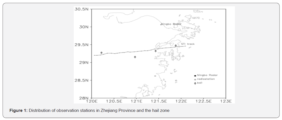
Because of the characteristics of high organization and severe disaster, supercell storms have been concerned since 1950s. Most hail is produced by strong supercell storms in mature stages. Triggered by a cold front, a series of convective storms occurred in the middle of Zhejiang Province of China on March 21, 2019, and lasted for 6 hours, which caused hail in Jinhua, Shaoxing, Taizhou, Ningbo and other nearby cities. They were of small scale and high difficulty in weather forecast (Figure 1). Conventional observation data and dual polarization radar data are used to analyze these hail processes, in order to improve the early warning of hail.
Analysis of the Weather Situation
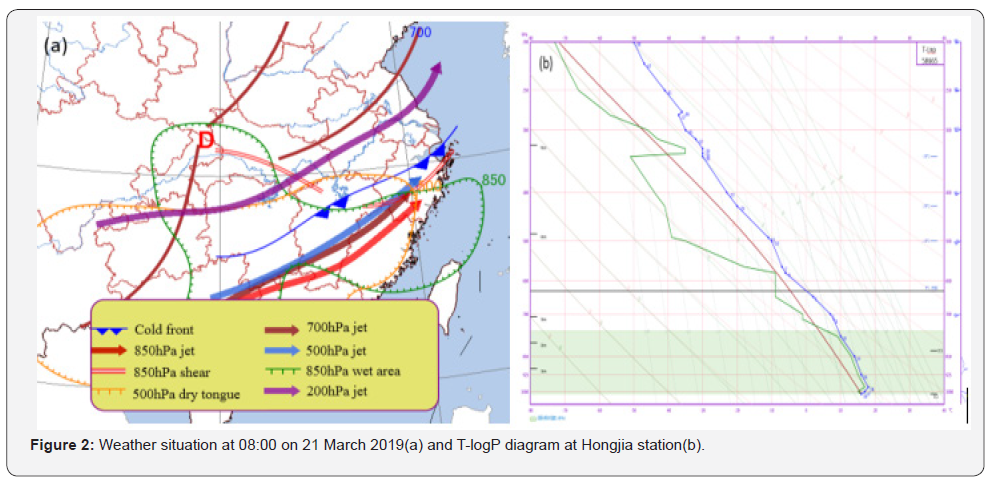
At 08:00 (Beijing Time, the same below) on the 21st, the hail area was in front of the 500hPa cold temperature trough. 200, 500, 700 and 850hPa all had strong southwest airflow transportation. The west of Zhejiang Province was in the left front of the right frontal zone of high-level jet and the exit of low-level jet, and the coupling of high-level and low-level jet was conducive to the development of convective upward movement [1]. At the same time, there was a northeast-southwest shear line in the middle of Zhejiang Province at 850hPa, and the surface cold front pressed southward to the northwest of Zhejiang (Figure 2a). The dry cold air with high speed was embedded in the wet area, and superposed on the warm energy tongue formed by the strong southwest jet in the lower layer, resulting in the increase of vertical decline rate of the temperature and the significant stratification of upper dry and lower wet, as well as the vertical shear of the environmental wind in the middle and lower layers. At 08:00 on the 21st, the vertical wind shear of 0-6km reached 48m/s. With the sounding of Hongjia (Figure 2b) in the south of Zhejiang, it can be found that the cloud bottom was low under high humidity in the lower layer, and the curve of temperature and dew point was in a shape of bell mouth from bottom to top. The vertical structure of upper dry and lower wet was conducive to the occurrence of hail. At the same time, the height of 0℃ and -20℃ was 4.2km and 7.1km respectively, which reached the index threshold of hail in Zhejiang.
Analysis of the Radar Echoes
Development of Radar Echoes
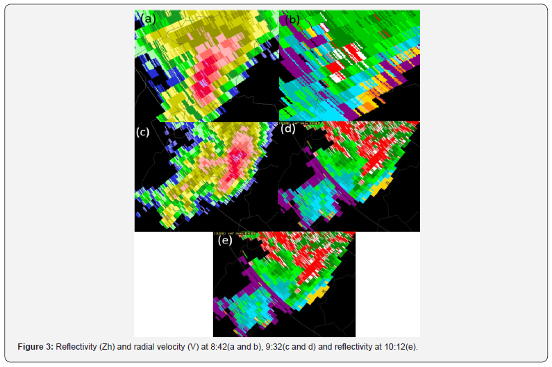
At 8: 42, a convective cell of mesocyclone style with symmetrical structure in the storm-relative mean radial velocity map (SRM) was located at 235°/ 182km (Figure 3a), southwest of Ningbo radar. The maximum rotation speed was 21m/s, which met the standard of strong mesocyclone [2]. There were found a hook echo on the south side of the storm, a wide inverted “V” with front inflow notch (FIN) on the east of the hook echo, and a rear inflow notch (RIN) on the west (Figure 3b), all of which were classic features of supercell storms. The presence of FIN and RIN indicated a strong front inflow and rear downdraft, which showed that the supercell had developed to a mature stage. As a result, the hail first occurred at 8:53.


At 9: 32, there was a convective cell, connecting with the supercell through a cloud bridge at the back (Figure 3c), and it had a mesoscale convective vortex (MCV) with a rotation speed of 7m/s. Afterwards, it gradually integrated into the main supercell storm. The combination made the storm maintain and strengthen, and the maximum rotation speed was also significantly increased (Figure 3d). At 9:54, in the southwest of the supercell storm, convective cells were continuously generated, and the maximum Zh rapidly increased to 50dBZ, and then integrated into the supercell storm, and afterwards, the characteristics of bow echo was shown at 10:12 (Figure 3e). When a supercell is embedded in a mesoscale convective system (such as squall line, etc.), it usually has a longer life and causes more serious disasters [3]. In this process, the rotation speed of the supercell maintained at the level of mesocyclone, and the hail occurred for the third time at 10:40. Up to 11:14, the main echo moved to the sea, and the supercell had three hail processes in three hours[4].


Evolution of the Supercell Storm
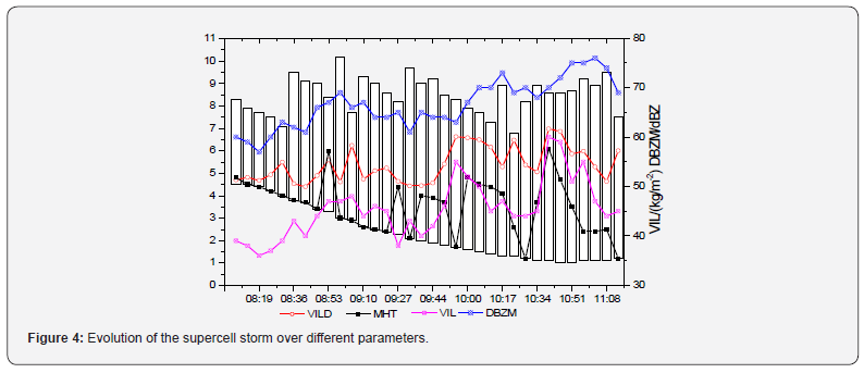
Figure 4 shows the evolution of the supercell storm observed by Ningbo radar. The white column is the height of the storm, and the red solid line of the abscissa is the duration of the three hail processes [5]. In the process of storm development, the maximum reflectivity (DBZM) of the three hailstorms was above 59dBZ, and the supercell increased like ladder with the maximum value[6]. The DBZM reached 76dBZ in the third hailstorm. Through the evolution of the maximum reflectivity height (MHT), it shown that the initial convective storm was in the middle troposphere, the height of the mass center was high, and it gradually extended downward. The convective storm was very strong in the whole life, the maximum reflectivity was above 60dBZ and the top of the storm was over 8km. The height of the storm’s mass center fluctuated three times, corresponding to the three hail processes[7]. At 9:32, MHT, VIL and VILD increased rapidly, and the maximum value of VIL reached 60g/kg.
Wu [8] found that there was a positive correlation between VIL and hail size through the study on characteristics of a series of supercells, and the hail occurrence corresponded to an obvious VIL jump (16-20 g / kg) in the mature stage[8]. At the same time, the probability of hail occurrence was greater when VILD was ≥ 4g/m3. Therefore, we often pay attention to the jump of VIL and VILD ≥ 4g/m3. The sustained high VIL (60-70g/kg) is usually used as the forecast index of hail larger than 5cm. By contrast, the maximum VIL less than 40-50g/kg is often ignored for hail smaller than 2cm in the nowcasting. Through the analysis of the hail processes, the VIL had a jump of 11-14g/kg before hail falling, and the jump of VIL was less than the traditional index, but the VILD was more than 6g/m3 and the maximum reflectivity Zh was up to 70 dBZ, therefore we should pay more attention in operational forecast (Table 1).

Conclusion
We analyzed the hail processes of a supercell in Zhejiang Province of China on March 21, 2019. The following conclusions can be drawn:
• The high trough, the shear line of 850hPa and the surface cold front provided suitable dynamic conditions for the supercell.
• The appearance of hook echo, FIN, RIN and bow echo can be served as hail features of supercells on weather radar echo images.
• The large values of Zh and VILD, and the jump of VIL are significant for hail occurrence.
Acknowledgement
This work was supported by open research fund of Fujian Meteorological Bureau (2018K08) and Hubei Meteorological Bureau (2019YJ01, 2020Z01).
References
- Browning K A, Foote G B (1976) Airflow and hail growth in supercell storms and some implications for hail suppression. Quart J Roy Meteor Soc 102(433): 499-533.
- Andra D L (1997) The origin and evolution of the WSR-88D mesocyclone recognition nomogram. In: 28th Conf. on Radar Meteorology, Austin, Texas 364-365.
- Atkins N T, Bouchard C S, Przybylinski R W (2005) Damaging surface wind mechanisms within the 10 June 2003 Saint Louis bow echo during BAMEX. Mon Wea Rev 133(8): 2275-2296.
- Lemon L R (1998) The Radar “Three-Body Scatter Spike”: An Operational Large-Hail Signature. Weather & Forecasting, , 13(2):327-340.
- Kumjian M, J Picca, S Ganson, A Ryzhkov, and D Zrnic (2010) Three-body scattering signatures in polarimetric radar data. NOAA/NSSL Rep 12.
- Kumjian M R, Ryzhkov A V (2008) Polarimetric signatures in supercell thunderstorms. J Appl Meteor Climatol 47(7): 1940-1961.
- Kumjian M R, Ryzhkov A V, Melnikov V M (2010) Rapid-scan super-resolution observations of a cyclic supercell with a Dual-Polarization WSR-88D. Mon Wea Rev 138(10): 3762-3786.
- Zhang P C, Wei M, Huang X Y, et al. 2018. Principle and Application of Dual Linear Polarization Doppler Weather Radar. China Meteorological Press (in Chinese).


