Community Based Coastal Aquaculture Site Selection for the Rural Poor
Nani Gopal Das* and Shahadat Hossain M
Institute of Marine Sciences and Fisheries, University of Chittagong, Bangladesh
Submission: February 19, 2018; Published: June 20, 2018
*Correspondence author: Nani Gopal Das, Institute of Marine Sciences and Fisheries, University of Chittagong, Bangladesh.
How to cite this article: Nani G D, Shahadat H M. Community Based Coastal Aquaculture Site Selection for the Rural Poor. Oceanogr Fish Open Access J. 2018; 8(1): 555726. DOI:10.19080/OFOAJ.2018.08.555726
Mini Review
Coastal aquaculture in Bangladesh was started in the early 1970s with extensive production system which gradually progress towards semi-intensive mode of shrimp monoculture and extended to about 150,000ha of coastal land. The extent of farming area has been horizontally increased that gradually encroached mangrove forest, agricultural land and wet meadows as well as creating ecological imbalance and environmental hazards. Unfortunately, there have been repeated production losses since 1994 principally for white spot syndrome virus (WSSV) epidemics along with related disease conditions. As a result semi-intensive farms have forced to stop the production and lots of ponds have become abounded. In order to analyze the current situation and to develop sustainable measures for aquaculture, land suitability assessment was carried out in Noakhali coast through scientific investigations considering water quality, soil characteristics, topography, infrastructure and socio-economic factors to identify the suitable areas for aquaculture development. Landsat TM satellite imagery and 24 thematic layers were analyzed with ENVI and ArcView, and developed a series of GIS models to identify and to prioritize the appropriate areas for aqua farming [1].
The Noakhali district is situated in the central coastal zone of Bangladesh along the northeastern coast of the Bay of Bengal. The geographical location is in between latitude 22°26¢ and 22°56¢ N and longitude 90°24¢ and 91°52¢E. The southeast and southwest sides of Noakhali have been exposed to the Bay of Bengal and the Meghna River respectively. The coastline of Noakhali is about 75km along with muddy and sandy-muddy shore. To ensure sustainable aquaculture development there is a great need to allocate aquaculture development in suitable locations to resolve competing demands for land/water, avoid undesirable effects on the environment, and to ensure the profitability in production [2].
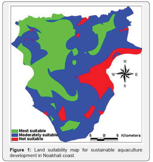
Satellite remote sensing and geographical information systems (GIS) can be served as an analytical tool for planning of aquaculture development and to examine the consequence of various development decisions before their use in the landscape. A total of 24 base layers (thematic maps) were grouped into four main land use requisites such as water quality, soil quality, topography, and infrastructure and socio-economic aspect. A series of GIS models was developed to identify and prioritize the most suitable areas for aquaculture (Figure 1). Out of 139,550ha study area of Noakhali coast, 45,225ha (32%) located in grassland, water bodies and paddy fields was most suitable, where 79,087ha (57%) located in the paddy cultivation and grassland was moderately suitable for aquaculture development. The remaining 15,238ha (11%) located mainly in the accreted zone and mangrove forest as well as in remote grasslands with less infrastructure facilities was classified as not suitable for aquaculture development [3].

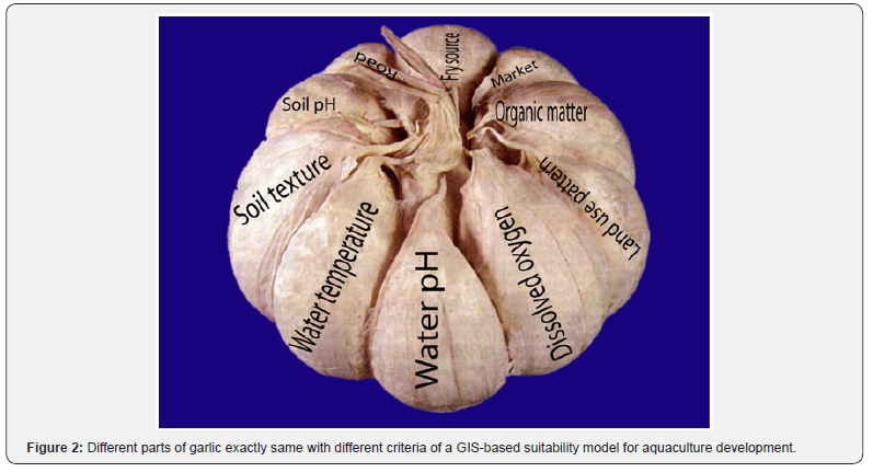
Multidisciplinary and the multisectoral approach, which are the key components to this research, could yield tangible results from the collective action and through applying handson approach to integrated coastal management. Indeed, the right approaches to tackle environmental disasters and enhanced fisheries production will be the development of a more comprehensive strategy and action plan for the integrated management of this area as part of the Bangladesh coast. So it can be possible to accept as much suitable areas that may occur as the compatible uses which can co-exist in harmony. Relevant example in this particular case is the co-existence of mangrove, fish, prawn, paddy and wet meadow in time sharing basis at Noakhali coast. It might be an excellent option maintaining the complete satisfaction of the environment, technology, economics and rural livelihoods that may be compared with garlic in which many individual parts naturally integrate together (Figure 2).

The GIS model incorporated 24 key environmental and socioeconomic criteria using field observation, survey, laboratory analysis and secondary data and then integrated through multicriteria evaluation approach to segregate the suitable zones for aquaculture development. Model verification was carried out by making comparison between predicted suitable areas and existing land use patterns in 40 selected sites of the study area with subsequent field visit and ground truthing. This study showed that GIS database of different formats and sources can be used effectively to establish spatial models in land evaluation for aquaculture. With the help of such maps, planners and decisionmakers would seek a wise balance between many conflicting demands being made on the coastal areas in question, ensuring that its limits of tolerance and capacity for sustainability are not exceeded [4-6].
Aquaculture development in suitable zones can involve the disadvantaged groups such as orphans, disables, women, or elderly people, with the aim to integrate them more strongly into the social harmony and to provide them with a decent livelihood. Community based aquaculture is an economically viable, ecologically suitable and socially acceptable allied activity and also may be served as the main dietary protein source for the rural poor. The socio-economic benefits derived from aquaculture expansion provide the provision of nutritive foods contributing improved life style to the poor, income generation and employment opportunity, diversification of fish production and create scope for foreign exchange earning through export of high-valued products. This is the only way to increase rural economy through the development of primary production sector and to overcome malnutrition for improvement of health condition of the rural community.
References
- Hossain MS, Das NG (2010) GIS-based multi-criteria evaluation to land suitability modelling for giant prawn (Macrobrachium rosenbergii) farming in Companigonj Upazila of Noakhali, Bangladesh. Computers and Electronics in Agriculture. Computers and Electronics in Agriculture 70(1): 172-186.
- Hossain MS, Chowdhury SR, Das NG, Rahaman MM (2007) Multicriteria evaluation approach to GIS-based land suitability classification for tilapia farming in Bangladesh. Aquaculture International 15(6): 425-443.
- Malczewski J (1999) GIS and Multicriteria Decision Analysis. Wiley, New York, USA, pp. 392.
- McErlean, AJ, O’Connor SG, Mihursky JA, Gibson CI (1973) Abundance, diversity and seasonal patterns of estuarine fish populations. Estuarine, Coastal and Marine Science 1(1): 19-36.
- Pereira JMC, Duckstein L (1993) A multiple criteria decision-making approach to GIS-based land suitability evaluation. International Journal of Geographical Information Systems 7(5): 407-424.
- Shafi M, Quddus MMA (1982) Fisheries resources of Bay of Bengal (Bonggoposagarer Matshaya Sampad, (In Bengali). Bangla Academy, Dhaka, Bangladesh.


