




 ASM Home



Abstract
The present study aimed to investigate the complexity of the social and environmental relationships within the community of Salvador Alvarado, Yucatán, Mexico. Particular attention was given to the vulnerability of the community in the face of the increasing intensity of climatic phenomena, including heavy rainfall events, strong winds, flooding, and prolonged drought periods.
A structured survey was designed and administered to adult residents in order to understand the socio-environmental conditions of the San Agustín ejido and its urban settlement. The survey addressed organisational and participatory strategies, access to basic services such as water supply, electricity, education, and healthcare, as well as the impacts of climatic events from the perspective of local inhabitants. The principal needs of the community were identified, and recommendations were proposed accordingly.
The findings were analyzed within the framework of the Social-Ecological System (SES) approach applied to the micro-watershed encompassing the locality of Salvador Alvarado within the San Agustín ejido. This framework revealed that local dynamics cannot be understood in isolation but rather as part of a complex network in which ecological, social, economic, and cultural factors interact. The approach made it possible to identify how productive activities, forms of community organization, access to and management of natural resources, and local environmental perceptions are directly linked to both the conservation status of the micro-watershed and the socio-economic conditions of the community.
The ejido assembly remains the principal decision-making body; however, gender- and age-related inequalities continue to limit equitable access to resources.
Likewise, the ejido forms part of the Puuc Biocultural State Reserve (Reserva Estatal Biocultural del Puuc, REBP), a protected area that promotes nature conservation through the participation of forestry and agricultural management programmes and organizations. Furthermore, the distinctive physiographic characteristics of the region, characterized by rugged terrain, pronounced altitudinal variation, and steep slopes, have contributed to the occurrence of severe flooding during prolonged and intense rainfall events, commonly associated with tropical storms.
Keywords:Risk; Perception; Flooding; Micro-Watersheds
Introduction
The Yucatán Peninsula is characterized by the coexistence of diverse forms of land tenure and natural resource management. Prior to the reform of the Mexican Agrarian Law in 1992, the ejido represented the principal form of communal land ownership among Maya communities [1]. At present, the use and management of natural resources are shaped both by local conceptions of the forest landscape (monte) and by collective agreements established to mediate between individual and community interests [2].
Ejidos in the Yucatán Peninsula encompass approximately 60% of the regional territory. This system of social land tenure includes individually allocated plots, communal-use lands, and human settlement areas [3]. It plays a fundamental role in the conservation of biocultural heritage, as the Maya communities inhabiting these territories have developed management practices that generate heterogeneous vegetation mosaics and diverse habitats based on traditional ecological knowledge.
The municipality of Tekax forms part of this regional context, where urban growth and expansion have transformed local ecosystem dynamics, generating a range of environmental impacts. The magnitude and direction of these impacts largely depend on the management and resource-use practices adopted by local communities [1]. Communities that have implemented sustainable management strategies are better able to meet the needs of their populations without compromising ecosystem integrity, thereby ensuring the long-term availability of natural resources.
Nevertheless, the prevalence of extractive activities within the region [3], together with the effects of global climate change [4], threatens ecological equilibrium by altering precipitation patterns, intensifying droughts and heatwaves, and progressively increasing average temperatures. These changes affect not only ecosystems but also the communities that depend upon them, which, despite possessing sustainable management strategies, face growing challenges in terms of resilience and adaptation.
The San Agustín ejido, located within the municipality of Tekax, was established in 1966 through the allocation of land to migrants from Tenkantó [2], primarily henequen farmers. Subsequently, as a result of southern colonization policies such as the National Land-Clearing Programme (Plan Nacional de Desmontes) implemented in 1975, collective livestock production units, beekeeping activities, and small-scale irrigation systems were established, alongside the gradual arrival of traditional maize farmers (milperos) from settlements located at the foothills of the Puuc Hills [1]. The settlement that serves as the administrative centre of the agrarian community is known as Salvador Alvarado.
This ejido is characterized by the coexistence of diverse social groups with distinct agrarian perspectives and management practices [1], including traditional milpa agriculture, fruit orchards, household gardens (solares), mechanized cultivation, livestock production, and beekeeping. This diversity has generated complex internal dynamics regarding land tenure, access to resources, and territorial governance.
Similarly, the ejido forms part of the Puuc Biocultural State Reserve (REBP), a protected area that promotes biodiversity conservation through forestry and agricultural management programmes and organizations [5]. In addition, the particular hydro geomorphological characteristics of the region, characterized by rugged topography, marked altitudinal gradients, and steep slopes, have favored the occurrence of severe flooding during prolonged and intense rainfall events, generally associated with tropical storms. These conditions have exacerbated the vulnerability of both the territory and its inhabitants [6,7].
Objective
The objective of this study is to examine the complexity of the social and environmental relationships within the community of Salvador Alvarado. Specifically, the study identifies community vulnerability to the increasing intensity of climatic events, including heavy rainfall, strong winds, flooding, and prolonged drought periods. It addresses organizational and participatory strategies related to the management and use of natural resources, the principal productive activities, and the availability of essential services such as water supply, electricity, education, and healthcare. Furthermore, it explores the impacts of climatic phenomena from the perspective of local stakeholders.
The main needs of the community are identified, and recommendations are proposed to address these challenges.
Rationale
Understanding the use and management of natural resources in rural contexts cannot be separated from the social conditions that shape the daily lives of local communities. In the case of San Agustín, extreme meteorological events that have occurred in recent years, such as the prolonged flooding caused by Tropical Storm Cristóbal in 2020 and the intense rainfall events of September 2021, have had significant impacts on household food security and material well-being, resulting in considerable losses of crops and [8].
These impacts are further amplified by the location of the ejido within a micro-watershed, where topographic and hydrological conditions favor water accumulation during periods of intense rainfall, thereby increasing the risk of flooding and groundwater well contamination [7].
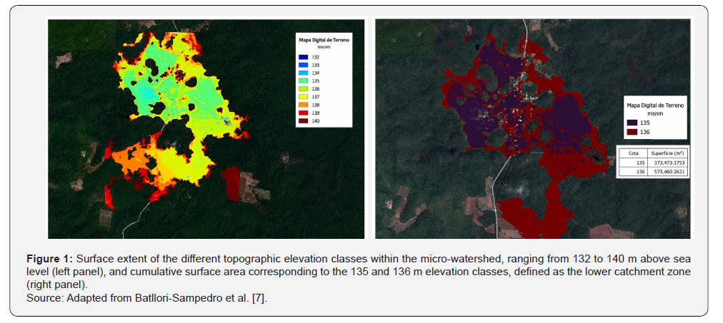
The lowland area of the micro-watershed, located between elevations of 135 and 136 m above sea level (masl), may be considered the principal functional zone of the lower catchment, extending from the pond depression situated at 132 masl to the 136 masl contour. This area covers 96.89 hectares, representing 24.45% of the total area captured in the LiDAR imagery. The probable overflow threshold begins at an elevation of 137 masl, as illustrated in the southern portion of Figure 1, encompassing a cumulative area of 121.14 hectares.
According to Figure 1, flood events exceeding this topographic threshold would result in water overflow from the northern section of the micro-watershed towards the upper drainage systems of Mesocatchment 6 [7]. These findings provide an indication of the potential surface water storage capacity of the micro-watershed and highlight its hydrological significance within the broader landscape.
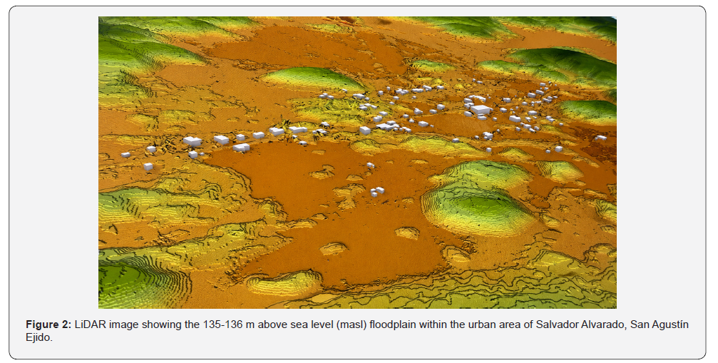
Although this hydrographic condition represents a significant opportunity for water capture and management, it also requires integrated management strategies that consider both forest and soil conservation, as well as the rehabilitation of traditional water storage systems. From the perspective of socio-environmental community management, as conceptualized within the Social- Ecological Systems (SES) framework, the micro-watershed encompasses not only physical components such as soil, water, and vegetation, but also the population that inhabits and utilizes these resources (Figure 2). As such, it provides a fundamental basis for sustainable planning and development [9] (Ministry of Environment and Sustainable Development, 2025).
The maximum flood level corresponds to the 137 masl topographic contour. A substantial proportion of the urban and agricultural infrastructure is located below this elevation threshold, thereby increasing its exposure to flooding events.
In this regard, micro-watersheds provide an appropriate spatial framework for the management and efficient use of local water resources, as well as for the planning of conservation, restoration, and sustainable environmental management actions. They also promote community participation around shared interests, including access to water resources and basic infrastructure (The Nature Conservancy, 2025). Therefore, the San Agustín micro-watershed constitutes not only a physical and natural unit but also a social one, functioning as a spatial framework for land-use planning and collective decision-making. It encompasses the area where productive activities, residential zones, conservation areas, and access routes are concentrated and interconnected.
Furthermore, the micro-watershed facilitates the identification of priority areas for agricultural, forestry, environmental conservation, and infrastructure development purposes, as well as zones particularly vulnerable to flooding during the rainy and hurricane seasons, where community assets and services are frequently affected.
This approach enables community decisions regarding land use, resource management, and the regulation of productive activities to be integrated coherently with the hydrological and ecological dynamics of the region. The delineation of the microwatershed is justified by the fact that the ejido territory is located within a natural catchment and drainage system, where topography, karstic processes, and terrain depressions direct surface runoff and water infiltration towards interconnected water bodies and hydrological flows. Consequently, any productive, infrastructural, or conservation-related activity undertaken within the area directly influences water availability and quality, as well as the water security of the ejido’s inhabitants.
These challenges become particularly significant when considering the high levels of structural poverty prevailing in the region. According to CONEVAL [10], 96.8% of the population of Tekax lives in conditions of poverty, while only 7.4% has access to healthcare services. Although approximately 68% of households have access to basic services, only 15.4% meet adequate standards regarding housing quality and living space.
In San Agustín, electricity and potable water services are reported to be unstable, reflecting a condition of structural vulnerability that constrains the community’s capacity to manage its resources sustainably [2].
In 2022, the ejido population consisted of 164 inhabitants distributed among 49 households, with an average age of 27 years among women and 32 years among adult men [2]. The three principal economic activities in the area are commercial trade, labour migration, and the production of maize under the traditional milpa system, fruit crops, and soybean cultivation. Beekeeping is also a successful economic activity within the community, while ecotourism has been identified as a sector with considerable growth potential. In the case of milpa agriculture and beekeeping, these traditional activities have been recognised as contributing to the conservation of the Puuc Biocultural State Reserve (REBP) [5] (REBP Management Programme, 2021).
The contribution of migration-related activities is reflected in remittances received primarily from young men with formal education who migrate to the United States of America due to limited local employment opportunities [5,11] (REBP Management Programme, 2021).
Government support programmes also constitute an important source of annual household income within the REBP. For households experiencing poverty, these transfers may account for approximately 12.18% of total income, while for households living in extreme poverty they may represent up to 25.79%, highlighting their importance for regional development [5].
The demographic structure of the ejido, combined with the productive activities and socioeconomic constraints described above, presents significant challenges for the preservation of traditional ecological knowledge and the strengthening of livelihood strategies based on the sustainable use of natural resources. Despite these difficulties, the community has participated in various institutional programmes and projects promoted by external stakeholders, including the Payment for Environmental Services Programme (PES), Sembrando Vida (SV), Producción para el Bienestar (PB), and the establishment of a Rural Production Society (Sociedad de Producción Rural, SPR).
These initiatives have promoted forest management, agroecological practices, territorial conservation, productive diversification, capacity building, and access to economic incentives. Nevertheless, participation in some of these programmes has been limited or selective, raising questions regarding mechanisms of inclusion, representation, and community appropriation of such initiatives [2].
A progressive loss of traditional ecological knowledge is also evident, particularly among younger generations. Migration and changing lifestyles have contributed to a weakening of connections with rituals, legends, and beliefs associated with local biodiversity (REBP Management Programme, 2021). This sociocultural transformation affects the ways in which individuals interact with their environment and may weaken the community bonds that underpin collective natural resource management [2,5,12].
In this context, environmental perceptions become particularly relevant, as they reflect the ways in which people understand and interpret nature through socially and culturally constructed perspectives that vary according to the knowledge systems from which they are derived [13]. On the one hand, environmental perception refers to the physical elements and natural processes not created by humans that individuals recognise within their surroundings [14]. On the other hand, it also encompasses the cognitive, emotional, and behavioural connections that people develop with the natural environment, shaped by cultural and psychological factors.
These connections influence how individuals understand and engage with the environment, directly affecting conservation practices and the use of natural resources [15].
This study provides a diagnostic assessment that may contribute to community strengthening and the development of mechanisms that support resilience to climate change. To achieve this, the conceptual framework of Social-Ecological Systems (SES) is employed, enabling the micro-watershed to be understood as a complex structure composed of multiple interconnected elements and organisational levels, thereby providing an integrated perspective on system functioning [16,17].
Theoretical and Methodological Framework
Social-Ecological Systems (SES)
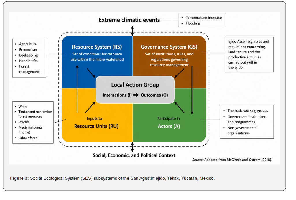
Social-Ecological Systems (SES) constitute a fundamental unit of analysis in studies of sustainable development [18,19]. These systems are conceived as complex structures composed of multiple interconnected subsystems that integrate both human and environmental variables [20,21]. They are characterised by their multi-level nature and by the presence of non-linear dynamics, in which social actors hold diverse perceptions and management objectives are often ambiguous or only partially defined [16,17]. The study of SESs provides a holistic understanding of system functioning, contributing to a more comprehensive interpretation of the use and management of common-pool resources and guiding management practices towards more sustainable outcomes [17,21]. In this regard, the micro-watershed of the San Agustín ejido can be understood as a Social-Ecological System, as it integrates both the biophysical components of the landscape and the social and cultural dimensions associated with their use and management. Ostrom’s theoretical framework proposes four interrelated subsystems for understanding the ecological, social, cultural, and political relationships associated with an ecosystem (Figure 3):
Resource System (RS)
This subsystem comprises the set of biophysical conditions that constitute the micro-watershed, including water resources, soils, vegetation, and wildlife. Together, these components provide the ecosystem services that are essential for community livelihoods and local development.
Resource Units (RU)
These refer to the specific elements derived from the forest ecosystem (monte) that can be extracted, utilized, or transformed. Examples include fuelwood, timber and non-timber forest products, medicinal plants, water for domestic and agricultural use, honey produced through beekeeping activities, and crops cultivated through local agricultural practices.
Governance System (GS)
This subsystem encompasses the laws, regulations, institutions, and agreements that govern access to and use of natural resources. In the case of San Agustín, governance is articulated primarily through the ejido assembly, where internal regulations, resource management agreements, landuse restrictions, and priorities for economic and territorial development are collectively established.
Actors (A)
This subsystem includes both internal and external stakeholders. Internal actors comprise ejidatarios (members of the ejido) and thematic working groups directly involved in resource management and productive activities. External factors include governmental institutions operating at federal, state, and municipal levels through development and support programmes, as well as non-governmental organizations, civil society groups, academic institutions, and international organizations that promote conservation initiatives and local development projects.
The four subsystems that comprise the SES are distinguished by colour. These subsystems interact with one another to form the Social-Ecological System of the San Agustín ejido. The dashed boundary indicates the continuous influence of extreme climatic events, as well as the broader social, economic, and political context on the functioning and interactions of the subsystems.
This complex interplay among the Resource System, Resource Units, Governance System, and Actors reflects the micro-watershed as a dynamic Social-Ecological System (SES), in which natural and human dimensions converge. Within this system, interactions occurring across multiple spatial and organizational scales shape not only the use and conservation of natural resources, but also the future of the community in terms of its social, cultural, and ecological sustainability.
Methodology
Study Area
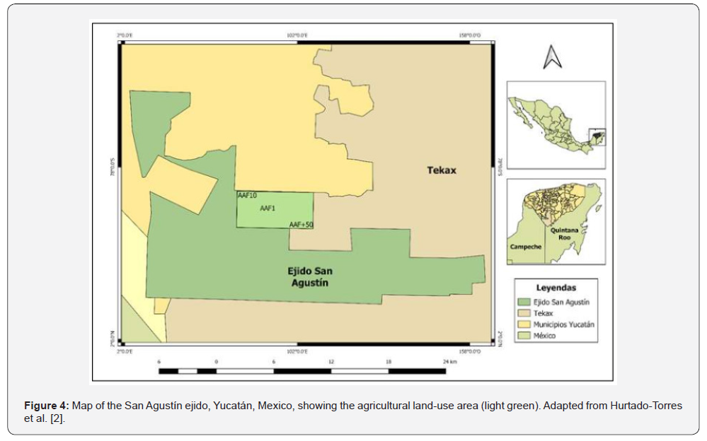
The community of Salvador Alvarado belongs to the San Agustín ejido, located within the municipality of Tekax in southern Yucatán State, Mexico (23°92′27″ W, 22°15′71″ N). The ejido covers approximately 35,000 hectares (Figure 4), of which 7,127 hectares have been incorporated into Payment for Hydrological Environmental Services schemes, 92 hectares correspond to the urban settlement area, and 2,254 hectares are managed under a forest management plan distributed across 20 management units of 112 hectares each [22].
The ejido is among the largest in Yucatán State and forms part of the Puuc Biocultural State Reserve (Reserva Estatal Biocultural del Puuc, REBP), a priority conservation area recognized for its biodiversity, ecosystem services, and rich Maya ancestral knowledge [2].
The climate is classified as warm sub-humid, with a mean annual temperature of approximately 26 °C and annual precipitation ranging between 1,000 and 1,200 mm [2]. The predominant vegetation is semi-deciduous tropical forest, characterized by seasonal leaf shedding during the dry season (November–April), followed by a rainy season extending from May to October [23]. The use, management, and diversity of vegetation are closely linked to the agroforestry management of the traditional milpa system. Through the practice of slash-andburn cultivation, successive stages of vegetation regeneration are generated, providing a range of ecosystem services, including soil regulation, carbon sequestration, and the provision of timber, fuelwood, and medicinal plants [24].
The karstic landscape, composed of partially soluble limestone bedrock, favours the formation of depressions and subterranean drainage systems, including xúuch, natural sinkholes that facilitate the infiltration of rainwater into the aquifer [25]. In some cases, these natural infiltration features have been inadvertently filled, thereby eliminating an essential mechanism for aquifer recharge and the regulation of local stormwater drainage.
Nevertheless, the community faces several environmental challenges. These include deforestation, the overexploitation of resources such as fuelwood, timber, wildlife, and medicinal plants, as well as the decline of key species resulting from habitat loss and hunting. Additional pressures arise from soil contamination and degradation associated with the recent incorporation of agrochemicals into agricultural practices, inadequate management of surface water due to the absence or deterioration of drainage channels and jagüeyes (traditional water storage ponds), and land-use change driven by external factors. Collectively, these processes intensify the environmental challenges faced by the local population.
Study Design
This study employed a mixed-methods approach. Data were collected through a survey instrument designed on the basis of the Social-Ecological Systems (SES) framework, comprising seven sections: (1) general information; (2) management and use of natural resources; (3) land tenure; (4) community organization; (5) relationships with the landscape and external stakeholders; (6) productive activities; and (7) access to basic services. The questionnaire consisted of 76 items, including open-ended questions, multiple-choice questions, and opportunities for additional comments. The survey also enabled the collection of information regarding the perspectives and perceptions of participants.
The unit of analysis comprised the residents of the Salvador Alvarado community in the municipality of Tekax, Yucatán. To determine the sample size, a cluster random sampling approach was employed based on the population reported by the National Institute of Statistics and Geography (INEGI) in 2020 (165 inhabitants). The finite population formula was applied to calculate the required number of participants:
n=N.Z2.p.(1-p)/E2.(N-1)+Z2.p.(1-p)
Where:
N = total population size (165);
Z = critical value of the standard normal distribution
corresponding to the desired
confidence level (Z = 1.96);
p = estimated population proportion (0.5);
E = desired margin of error (0.05)
According to the sample size calculation, the required sample consisted of 51 respondents. However, owing to participant availability and the time constraints associated with fieldwork, only 41 surveys were completed. In addition, eight audio recorded interviews were conducted with key informants following the provision of informed consent. The purpose of these interviews was to gain a more detailed understanding of the local context and of community members’ relationships with natural resource use, land tenure, social organization, the impacts of climatic events, and access to essential services.
The inclusion criteria were: (i) being at least 18 years of age, (ii) willingness to participate, and (iii) provision of informed consent. Fieldwork was conducted during August 2025.
Data were initially collected through paper-based questionnaires and subsequently digitized using a Google Forms® survey instrument. Each participant was provided with an informed consent form, the contents of which were explained prior to participation. This procedure ensured voluntary participation and adherence to the ethical principles of confidentiality and autonomy.
Quantitative data were analyzed using Microsoft Excel® spreadsheets, with percentages calculated from the responses of the 41 participants. During the qualitative phase, audio recordings were transcribed into Microsoft Word® with the assistance of the online transcription platform Transcription®. To ensure accuracy and reliability, all transcripts were carefully reviewed by two members of the research team.
Subsequently, qualitative data were analyzed using the specialized software ATLAS.ti®. Analytical categories were developed from participants’ narratives to explore perceptions related to key themes, including natural resources, productive activities, community organization, basic services, and climatic events. A total of 18 codes were generated: (1) loss of traditional customs and practices; (2) community practices; (3) thematic group activities; (4) gender roles; (5) regulatory factors; (6) resource extraction by external actors; (7) loss of natural resources; (8) training and capacity-building activities; (9) government support, resources, and programmes; (10) loss of economic resources; (11) conservation perceptions; (12) expressed needs; (13) perceptions of water resources; (14) use of medicinal plants; (15) forest resource management; (16) crop diversity; (17) group-based organization; and (18) land tenure. These codes were subsequently grouped into two overarching thematic categories: “Perceptions” and “Forest Resource Use and Extraction”.
Results
Extreme Climatic Events
Given the increasing intensity and frequency of extreme climatic events, including hurricanes, heavy rainfall, and droughts associated with climate change [4], together with the socioeconomic marginalization characterizing the region [26], survey participants were asked about the principal climatic phenomena affecting the community and their associated impacts, particularly in terms of losses of material possessions, agricultural production, and other assets.
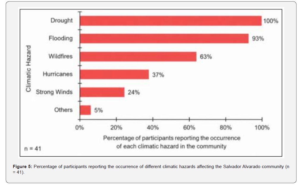
Community members reported a high recurrence of adverse climatic events, with drought identified as the most frequent and persistent hazard. All participants (100%) indicated that drought occurs on an annual basis and represents the most significant climatic impact experienced by the community (Figure 5). Flooding was also reported as a recurrent phenomenon, with 93% of participants recognizing its occurrence, particularly during the last three to five years, with the events of 2020 being especially prominent. Although less frequent, wildfires were reported by 63% of participants, who indicated that their occurrence is variable and often associated with human activities, with a greater incidence in areas adjacent to road corridors.
In relation to the above, 85.37% of participants reported having been directly affected by extreme climatic events. Participants were therefore asked to describe the impacts experienced according to the type of climatic hazard, the nature of the damage incurred (material losses, crop losses, or other impacts), the extent of the affected area (expressed in dimensions or measurement units), the dates on which the events occurred, and their frequency.
Crop losses, reported by 97.56% of participants, constituted the most significant impact associated with droughts and/or flooding events that have occurred in recent years.
These events had direct consequences for milpa fields, agricultural plots, and household gardens:
“When the fields become flooded, there will be no harvest. Many of the crops die because they remain underwater and the water becomes warm as the sun comes out and stays overhead. The flooding can last for three or four days. Once the water reaches this level and remains there, it becomes extremely hot.” (53-year-old participant).
In response to periods of drought, some interviewees suggested the implementation of irrigation systems as a potential adaptation measure. At least two participants indicated that they already employ irrigation as a mitigation strategy; however, they reported that it is often insufficient during prolonged drought periods due to the limited availability of water resources:
“Well, I would say they have adapted. The plants still wither, but we try to help them. We give them a little water or irrigate them by hand, just enough to keep them alive.” (53-year-old participant).
Among the principal crops affected by flooding within the milpa system, maize (Zea mays) was identified as the most vulnerable. In contrast, during periods of drought, annatto (Bixa orellana) was reported as the crop most severely affected:
“In the areas where we farm, annatto was heavily affected by the drought, and many plants died last year. Likewise, flooding affects maize, soybean, and virtually any crop planted in low-lying land, which is always vulnerable to damage.” (22-year-old participant).
Losses of medicinal plants cultivated in household gardens were also reported during periods of drought:
“Medicinal plants? Yes, during drought periods we sometimes lose them.” (Participant).
The second most frequently reported impact was material loss, mentioned by 34.15% of participants. These losses included damage to household infrastructure, furniture, and electronic equipment. The third most frequently reported impact was the loss of livestock and domestic animals, cited by 19.51% of participants. Both types of losses were primarily associated with flooding events affecting residential areas.
In response to these impacts, participants reported a range of coping and adaptation strategies aimed at reducing damage. These included relocating animals and personal belongings to the community administrative centre (comisaría) or seeking temporary shelter with relatives living in higher-elevation areas less susceptible to flooding. However, several participants noted that these measures are not always feasible, as flooding events often occur during the night, leaving insufficient time to implement preventive actions.
Resource Units
Among the natural resources most frequently utilized by community members, fuelwood (28%) and well water (22%) were the most commonly reported, followed by timber (17%), wildlife, and medicinal plants (16% each). Commonly used medicinal plants included rue (Ruta graveolens), annatto (Bixa orellana), basil (Ocimum basilicum), and epazote (Dysphania ambrosioides), among others.
These findings highlight the community’s close relationship with the surrounding forest ecosystem (monte), a connection that was also reflected in participants’ testimonies describing temporary permits and ejido regulations governing resource use. Nevertheless, participants also perceived a decline in the availability of natural resources, which they attributed to unsustainable management practices and unregulated extraction by individuals from outside the community:
“We have a permit that allows us to make use of these resources, but it is only temporary. The availability of fuelwood has declined somewhat because people from outside the community come and take it away.” (24-year-old female participant).
In addition, participants expressed concerns regarding community control over the territory and the capacity of local institutions to regulate access to and use of natural resources:
“Many people from other localities come into the area to hunt without us noticing.” (24-year-old participant).
These statements reinforce the need for community-based mechanisms of monitoring, control, and regulation to address pressures arising from external actors.
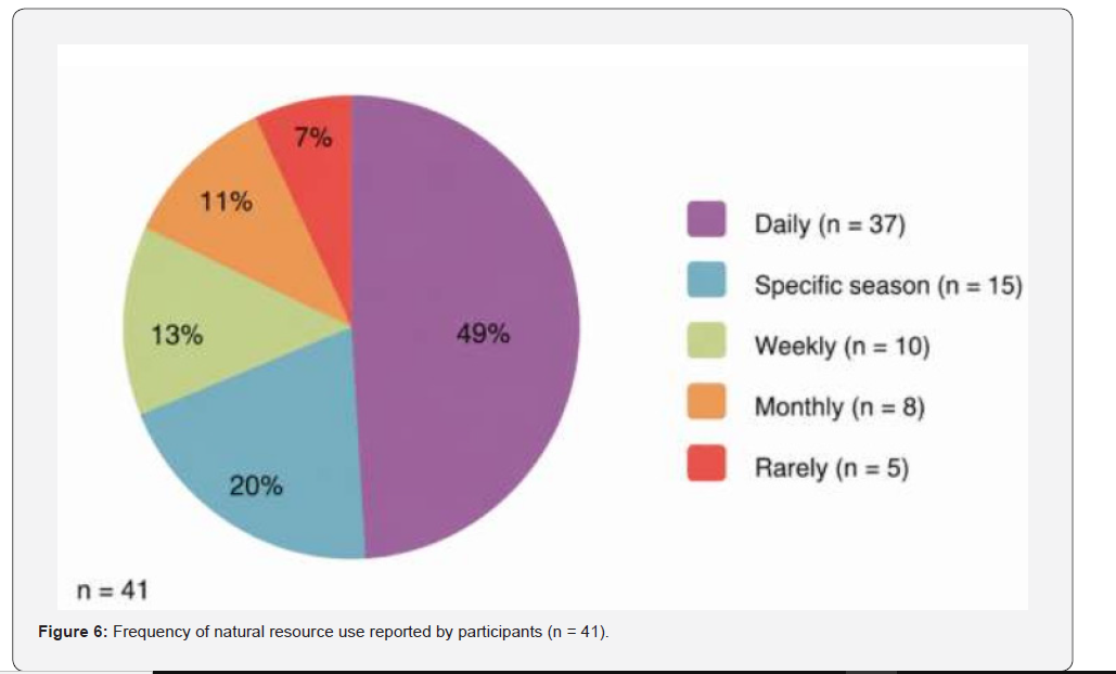
A total of 49% of participants reported using natural resources on a daily basis (Figure 6), highlighting the community’s strong dependence on these resources for everyday livelihoods. In particular, fuelwood and well water were used with high frequency, underscoring the importance of ensuring their sustainable availability. Several participants also described local resource management practices based on accumulated experience and traditional knowledge:
“...because of the type of forest found here, it regenerates almost naturally on its own.” (53-year-old participant).
Formal forest management programmes were also mentioned as an important mechanism for regulating resource use and promoting conservation:
“...we have a permit and an approved management programme that allows us to make use of the resources...” (53-year-old participant).
Participants further reported a progressive erosion of traditional ecological knowledge related to the use of natural resources. This phenomenon reflects challenges that extend beyond ecological sustainability and encompass cultural continuity, particularly with respect to the knowledge and use of medicinal plants in traditional healthcare practices:
“I do not think the plants themselves have declined; rather, what has declined is their use and the tradition of using them.” (53-yearold participant).
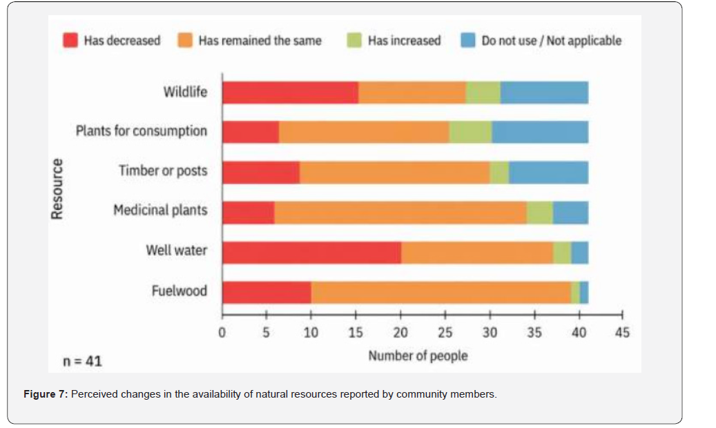
The natural resources perceived to have declined most markedly were well water (48.8%) and wildlife (36.6%) (Figure 7). In contrast, the availability of fuelwood, medicinal plants, and timber was generally perceived as stable, although some participants also reported declines in these resources.
The interviews revealed a range of factors contributing to these perceived changes, including the impacts of climate change—particularly flooding—as well as resource extraction by individuals from outside the community. Regarding medicinal plants, participants emphasized that their reduced use is primarily associated with the erosion of traditional knowledge, rather than with a decrease in their actual availability.
With respect to well water, participants attributed its reduced availability to increasingly irregular rainfall patterns observed over recent years, together with population growth within the community, which has increased water demand beyond the capacity of a single well. Participants also highlighted the abandonment of traditional rainwater harvesting systems, such as chultunes, sartenejas, and aguadas, as an additional factor contributing to water scarcity.
Overall, these findings illustrate the complex interaction between ecological, social, and cultural factors shaping changes in the availability, access to, and management of natural resources.
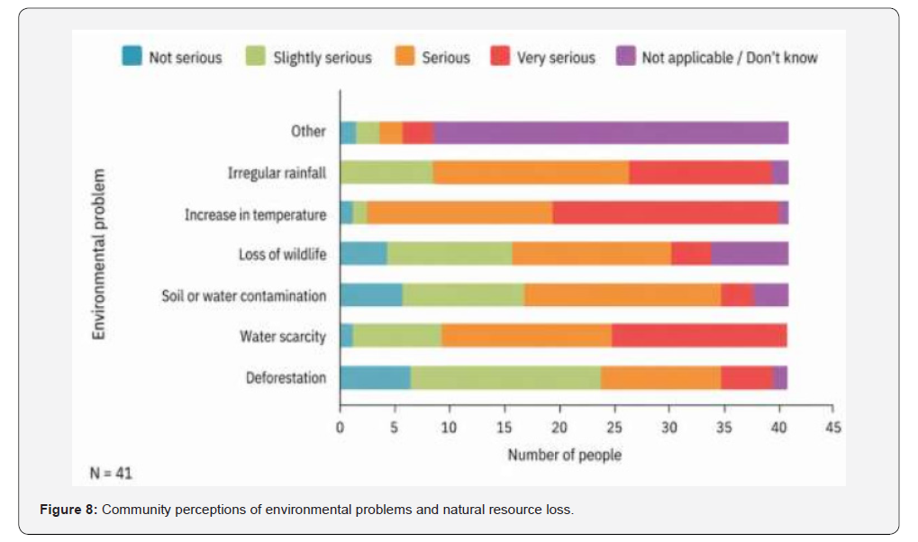
The environmental issues most frequently identified as “very serious” were rising temperatures (51.2%) and water scarcity (43.9%), followed by increasingly irregular rainfall patterns (36.5%) (Figure 8). These issues are directly linked to local productive activities, particularly agriculture, and affect both agricultural cycles and overall environmental health. Survey responses revealed widespread concern regarding the transformation of the landscape and its consequences for local livelihoods:
“Sometimes the rains do not come, or they arrive when they are no longer needed, and everything is lost.” (45-year-old female participant).
The perception of these environmental changes was also accompanied by a recognition of the ecological and cultural significance of the surrounding forest (monte), which participants viewed as a natural buffer against extreme heat and biodiversity loss.
The frequent and everyday use of natural resources highlights the community’s strong dependence on ecosystem services. Although some resources were perceived to remain relatively stable, participants identified several negative impacts associated with climate change, the erosion of traditional ecological knowledge, and unregulated resource extraction by external actors. These findings underscore the need to strengthen community-based environmental governance systems, promote the sustainable use of natural resources, and revitalize traditional ecological knowledge as a long-term strategy for climate change adaptation and biodiversity conservation.
Basic Services
Water Supply and Electricity
Basic services constitute the minimum conditions that a dwelling should provide to ensure an adequate standard of living. Access to a safe water supply, solid waste collection, electricity, and domestic fuel for everyday activities is widely recognized as the four fundamental components of adequate housing. Assessing access to these services is particularly important in the community of San Agustín, as its location in the southern region of the state of Yucatán is characterized by high and moderate levels of marginalization [26]. The survey aimed to collect information on access to water supply, electricity, healthcare, and education services, while also exploring participants’ perceptions of these resources. High levels of dissatisfaction were reported regarding the first three services, mainly owing to their limited availability or intermittent supply. With respect to healthcare, participants expressed the need for an adequately equipped health facility staffed by qualified healthcare professionals.
Regarding the water supply, the survey question referred specifically to drinking water. However, the community relies primarily on water extracted from a communal well. Although this source does not meet the criteria for potable water, for the purposes of this study it is considered as access to a piped water supply. Under this definition, 83% of participants reported having access to piped water, whereas the remaining 17% lacked access to this service, highlighting a persistent need to improve water accessibility within the community.
Several participants attributed this situation to population growth within the community, together with the lack of upgrading and maintenance of the water pumping system, as illustrated by the following testimonies:
“We have discussed the fact that the system needs to be expanded. It needs an extension or refurbishment—whatever you want to call it—because I believe it was built around 30 years ago. At that time, when there were only a few houses here, it worked well. However, the community has grown, so the system now needs to be expanded.” (53-year-old participant).
“From what I can see, the water supply is becoming increasingly limited because families in the community are getting larger. Either the pump is too small or the water supply well is no longer sufficient. People often tell me, ‘I didn’t receive any water,’ ‘Only a small amount of water reached my house.’ So yes, we do have problems with the water supply.” (64-year-old participant).
With respect to electricity supply, just over 95% of participants reported having access to the service. This finding suggests that, unlike the water supply system, the electricity infrastructure has been periodically upgraded to accommodate the community’s population growth.
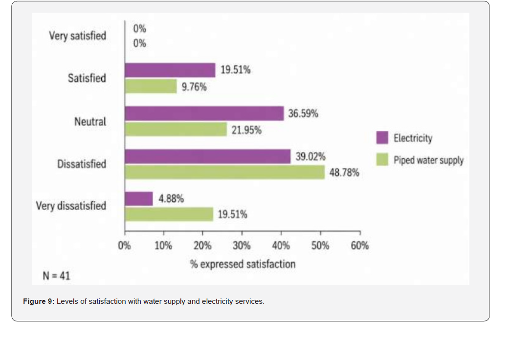
Despite the broad coverage of both services, participants expressed considerable dissatisfaction with their quality and reliability. Regarding the water supply, more than 68% of respondents reported being at least somewhat dissatisfied with the service. When asked about the reasons for this dissatisfaction, approximately 83% indicated that the water supply was neither reliable nor continuous.
Participants explained that water distribution is rationed across the community, with supply alternating between different sectors on consecutive days: one day for the northern part of the community and the next for the southern part. In both cases, the pumping system operates for approximately two hours each morning, generally between 11:00 a.m. and 1:00 p.m., although some participants reported that pumping occasionally begins earlier, at around 9:00 or 10:00 a.m.
Although electricity supply was generally perceived to be of higher quality than the water service, 43.9% of participants reported being dissatisfied with it (Figure 9), while 65.9% stated that the electricity supply was not reliable. According to participants, power outages occur frequently, with interruptions taking place at least once a week and lasting from several hours to several days. The most severe disruptions occur during the rainy season, when strong winds regularly damage the electricity network, resulting in outages that typically last between one and three days before service is restored, although longer interruptions were also reported.
Healthcare Services
Ninety-five per cent of respondents reported having no access to public healthcare services within the community. Although there is a designated space intended to function as a clinic, the community lacks a permanent physician as well as essential medicines required for the treatment of basic health conditions. As a result, residents must travel to the nearest community, located approximately 15 km away, in order to receive medical care. In some cases, due to the lack of medicines or adequate capacity, residents travel to Oxkutzcab, Tekax, and even Mérida to access healthcare services. Others opt to seek care from private medical providers.
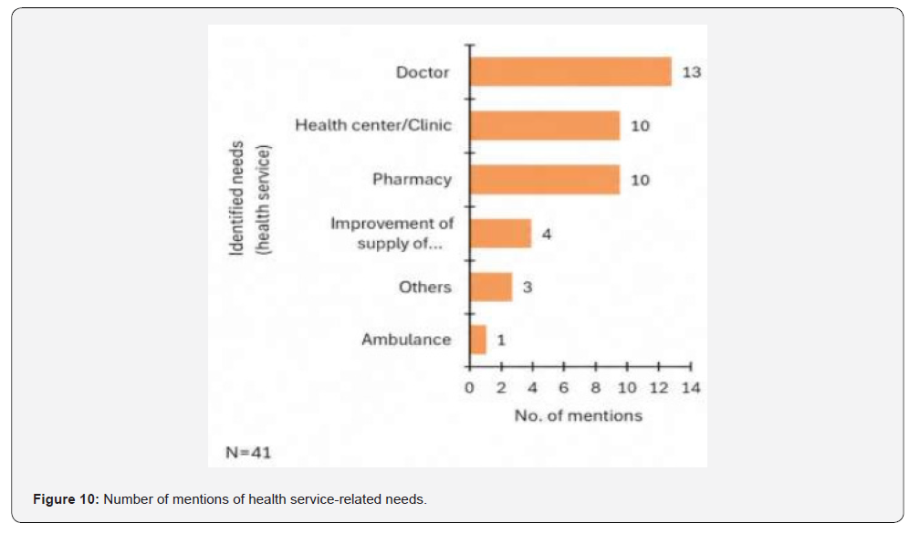
When asked about the healthcare services most needed in the community, the main responses included the presence of a resident physician, a fully equipped clinic or health centre, and a dispensary stocked with essential medicines (Figure 10). Additional concerns were also raised regarding improvements in water supply, particularly water potability and the construction of a new well to increase resource availability.
Education Services
With respect to public education services, the community has access to both primary and secondary schools, which operate under a multigrade teaching model. In the case of secondary education, it was noted that some cohorts did not reach the minimum enrolment required for the formation of a class group; as a result, students must travel to the nearby locality of Benito Juárez. The same locality is also where students attend upper secondary education, as the community does not have a high school.
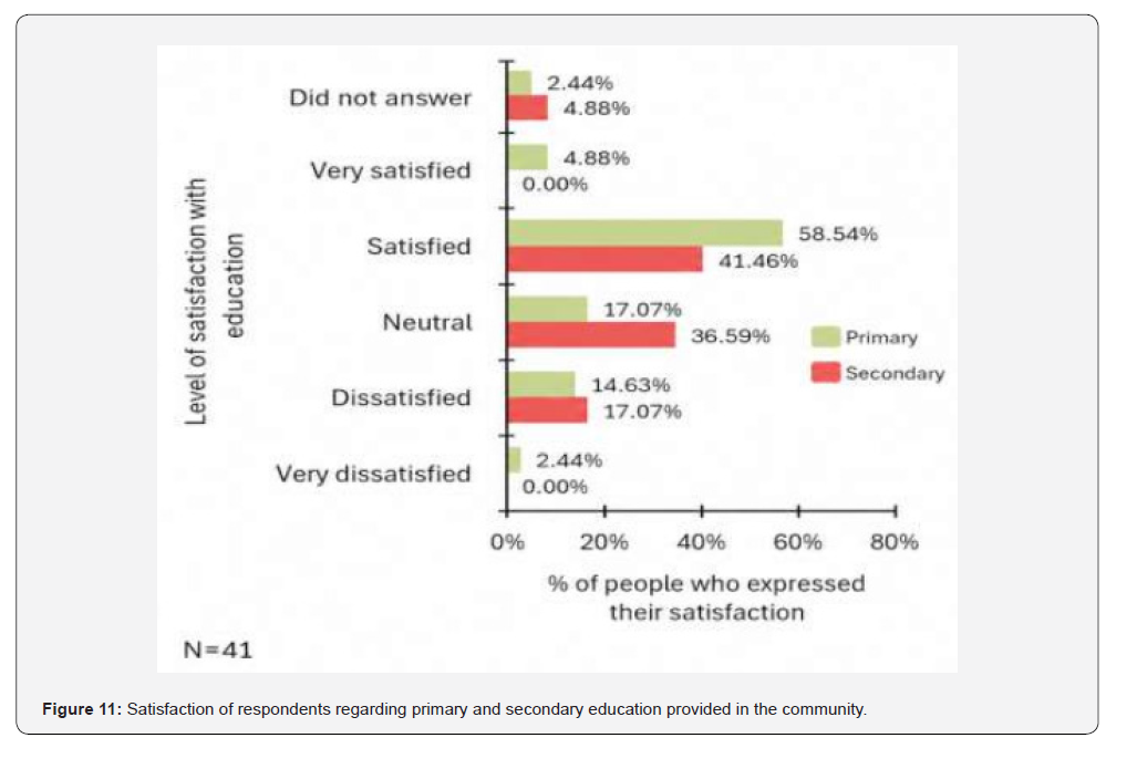
The survey indicates that for primary education, 63.42% of respondents (Figure 11) reported being at least satisfied with the teaching model. Some participants noted that educational quality has improved in recent years; however, annual teacher turnover, the multigrade system, the limited number of teachers, and their occasional absences from class contribute to lower levels of satisfaction.
In the case of secondary education, satisfaction levels are lower, with 41.46% of respondents reporting being satisfied and 36.59% indicating a neutral perception (Figure 11). According to participants, the establishment of the secondary school represented an important improvement, as some students previously had to leave the community to attend classes. However, concerns remain regarding the lack of permanent teaching staff, insufficient number of teachers, and the perception that classes function more as tutoring sessions rather than fully structured programmes equivalent to those provided by the Ministry of Public Education (SEP).
Governance System
Ejido Assembly
The Ejido Assembly is the main decision-making body, influencing 86% of the groups. This is followed by the participation of governmental institutions such as municipal authorities and government agencies (SEDER, SEMARNAT, CONAFOR), which have a voice in 43% of the organizations. Finally, external institutions such as JIBIOPUUC and The Nature Conservancy (TNC) participate in decision-making processes in 14% of the groups.
Formally established groups tend to have more clearly defined internal governance structures, whereas informal groups rely primarily on collective decision-making and informal external support [27].
Stakeholders
Access to infrastructure and resources
Groups with the greatest infrastructure and equipment are
those that have achieved formalization and gained access to
government support programmes, such as:
i. San Agustín Indigenous Tourism: dining facilities,
toilets, trails, and a camping area.
ii. Sawmill: carpentry workshop equipped with power
tools.
iii. Sembrando Vida: nursery, spray pumps, and a bio
factory.
In contrast, non-formalized groups (particularly those led by women) rely on shared community spaces and have limited access to equipment, which restricts their production and marketing capacity. In addition, the lack of irrigation systems was identified as a critical need.
Thematic working groups
A total of 14 organizations and community groups were identified, exhibiting diverse organizational structures and varying degrees of formalization within the community. These organizations are primarily engaged in productive activities related to the use of natural resources, the production of handicrafts, and the provision of community services. Table 1 presents the main findings according to type of activity, level of formalization, available infrastructure, participation in decisionmaking, access to resources, and gender composition.
Main activities
The activities carried out by the groups are grouped into five
categories:
i. Natural resource use: these represent 50% of the
organizations, highlighting honey production, the use of timber
and non-timber forest resources, and agriculture through the
Sembrando Vida programme.
ii. Handicrafts and textiles, comprising groups specializing
in wood carving, hammock weaving, and the production of textile
goods, mainly made up of women.
iii. Community governance: including the ejido assembly,
the potable water committee, and the citizen council of the
JIBIOPUUC.
iv. Finally, community-based tourism, led by the San
Agustín Indigenous Tourism cooperative.
Type of formalization
This refers to whether a group is formally recognized through legal documents or official records. Of the 14 groups identified:
i. 45% are formalized as cooperatives or committees,
which has enabled them to receive institutional support from
various governmental and non-governmental organizations
(Turismo Indígena, Tumbel Kuxtal, sawmill, Sembrando Vida, and
the potable water committee).
ii. 7% are in the process of formalisation; another 7% have
been specifically organised, as in the case of JIBIOPUUC.
iii. Six groups operate without formalisation, although in
most cases they actively participate in the ejido assembly.
Governmental institutions and programmes
The community, through its organisations, receives support from various external bodies, both governmental and nongovernmental. These forms of support target different sectors of the population and include technical training, financial assistance, in-kind donations, and infrastructure provision.
Of the total number of interviewees, the most frequently mentioned programmes were Sembrando Vida (27%), the Payments for Environmental Services and Forest Development programme of SEMARNAT–CONAFOR (15%), and PROAGRO of SADER (14%). These three programmes account for the highest number of mentions and are primarily targeted at farmers and thematic community groups.
On the other hand, non-governmental and technical organisations such as JIBIOPUUC, Co’ox Mayab, and TNC provide support to the community, although less frequently (between 2% and 5% of mentions). Their involvement focuses on meliponiculture, ecotourism, and environmental conservation, through donations and technical assistance. The Autonomous University of Yucatán (UADY) engages intermittently, reflected in its low percentage of mentions (2%), with some community groups, without specifying the type of support provided, although it can be inferred to be technical and targeted in nature.
Perceptions
Understanding the perceptions of local inhabitants makes it possible to identify the main needs, concerns, and social priorities, as well as existing agreements and conflicts related to land use, resource conservation, and social organization. In this sense, the analysis of perceptions is fundamental for designing land-use planning and socio-environmental management strategies that are culturally appropriate, socially accepted by the community, and sustainable over time. Furthermore, it provides key information for both local authorities and external institutions (public and private) to better understand the social reality of the ejido and to guide their interventions while respecting the population’s perspectives and expectations.
The analysis of perceptions was structured into three groups: (i) perceptions of material resources and their relationship with ecology; (ii) symbolic and cultural perceptions; and (iii) economic and functional perceptions. These groups comprise four classification categories, linking each group with conservation, economic resources, loss of natural resources, and customs and traditions (Table 2).
Recommendations
Improvement in access to piped water
From the analysis of information and collective reflection with community stakeholders in San Agustín, and with regard to public services for domestic use, the main need is the improvement of the piped water supply system. Although 83% (34 people) reported having access to the service, 95% (39 people) reported being at least dissatisfied with its functioning. The main causes of this dissatisfaction are intermittent supply, segmented distribution, and low pressure, which prevent water from reaching all households adequately. This situation generates inequality in access to a vital resource, forcing some families to rely on unsafe or costly methods such as carrying water in containers, affecting both health and the time available for productive or community activities.
Limited access to water affects not only domestic consumption but also productive activities, especially agriculture. The increasing frequency, intensity, and duration of droughts require the consideration of irrigation practices to ensure the survival of crops, which are essential for subsistence and the local economy. In this sense, water availability and quality are essential for productive security, food security, and territorial sustainability.
The community not only recognizes these problems but also identifies solutions. Among the proposed measures to improve the availability and quality of piped water is the construction of a new community well in a higher area, in order to expand access and ensure water security. The elevated location aims to prevent potential contamination of the well during flood events, thereby protecting water quality and reducing the risk of waterborne diseases. However, the main challenge is the high cost of the project, estimated by the ejido commissioner at around two million pesos, due to the depth of the aquifer (approximately 180 meters) and the required pumping system. This figure does not include the expansion or upgrading of the existing distribution network, which increases the overall cost and requires further technical study and planning.
A second proposal, considered more feasible by the community, consists of increasing system capacity by replacing the current pump with a more powerful one, as it has been indicated that the existing pipes can withstand such an upgrade. This change would extend water supply coverage to households that currently do not receive water and increase daily supply periods. It would also enable irrigation through water transport for crops that require it. The intervention would involve pump replacement and training for its operation, making use of existing infrastructure. To comprehensively address the water supply problem, it is recommended to seek infrastructure funding that considers population growth and productive needs. This should be based on technical studies of the local aquifer’s carrying capacity and participatory community mapping of the water system, in order to identify wells, networks, failures, uncovered areas, and the main problems identified by the community.
Subsequently, it is necessary to document water needs for both human consumption and productive uses (such as agriculture and livestock), considering medium-term population growth and demand scenarios. Likewise, a legal and regulatory diagnosis is recommended through the review of existing permits, well regularization, and the legal status of the water system.
This type of study could be supported by the Municipality of Tekax, the National Water Commission (CONAGUA), or the Mexican Institute of Water Technology (IMTA). Once the most appropriate project is identified, funding could be sought through public funds such as the Social Infrastructure Contributions Fund (FAIS) or urban improvement programmes of the Ministry of Agrarian, Territorial and Urban Development (SEDATU). Technical and financial support could also be obtained from organizations such as the FEMSA Foundation, Coca-Cola Foundation, universities, or research centres for studies, infrastructure design, or community training.
Recovery of traditional water harvesting and drainage systems (chultunes, aguadas and sartenejas)
The community’s traditional knowledge offers valuable solutions for addressing water scarcity. Systems such as chultunes, sartenejas, and aguadas (natural or constructed) are ancestral structures developed by Maya peoples to capture and store rainwater, enabling water supply during dry seasons or in areas without access to surface water bodies [25]. Beyond their practical function, these systems hold deep cultural value, as they reflect the respectful and harmonious relationship that communities have historically maintained with nature.
Chultunes, for example, were often built near dwellings, milpas, or ceremonial sites, and were considered sacred spaces associated with rain, soil fertility, and life [25]. Aguadas or natural ponds adapted for water harvesting, as well as sartenejas—rock depressions that retain water—also represent expressions of traditional ecological knowledge that integrates observation, respect for the landscape, and local survival strategies [25].
These traditional systems enable the sustainable use of rainwater, particularly during drought periods or when modern systems fail. They are locally adapted, low-cost, and low-impact solutions that have long formed part of the region’s traditional water management practices. Their recovery strengthens community resilience, reduces pressure on the aquifer, and promotes the intergenerational transmission of environmental knowledge.
To support the recovery of these systems, it is recommended to carry out maintenance of existing infrastructure located within the community, as well as to implement eco-technologies for rainwater harvesting in relevant projects, such as those mentioned by the women’s group Saasil Ek (see table), which is involved in vanilla production. In addition to these specific solutions, their reappropriation could be strengthened through intergenerational workshops, where older community members share their knowledge of construction techniques and the social uses of these systems, thereby reinforcing community cohesion and cultural identity.
These actions could be supported by JIBIOPUUC as a technical institution seeking to facilitate linkages and funding from programmes related to climate change adaptation, community infrastructure, or biocultural heritage conservation. Collaboration with research centres or universities such as CINVESTAV, CICY, or UADY is also recommended, as they can contribute to the documentation, design, and monitoring of these initiatives, ensuring both their technical feasibility and cultural relevance.
Shelter for hurricanes and floods
Based on the experiences of local residents, the construction of a shelter represents a need, although not for all households. This is due to the location of dwellings. Some homes are situated on higher ground, which appears to reduce their vulnerability to flooding. However, there is a sector of the community whose houses are located in low-lying areas or slight depressions, increasing their risk of flooding and material losses.
During the rainy season, families remain attentive to weather forecasts and, within their means, adopt preventive measures. Nevertheless, flooding can reach such magnitude that it affects basic services, including water supply and the lack of electricity. In addition, in some households in Salvador Alvarado, water levels have reached approximately 80 cm, making it difficult to remain in the homes.
For this reason, residents indicate that the construction of a community shelter is an alternative form of protection during the rainy season. This shelter should be strategically located, taking into account both local ecological knowledge from community members and previous studies, as well as topographic analyses, so that it provides safety and protection against vulnerability to climatic factors.
Resolution of conflicts over resource use with other communities (hunting, firewood collection, and deliberate fires)
One of the issues of greatest concern for the community is the conflict with people from neighbouring communities who enter the San Agustín forest without authorization to hunt, collect firewood, or carry out activities that put natural resources and territorial security at risk. These practices compromise biodiversity, the natural regeneration of the forest, and community safety.
Exploitation by third parties threatens local benefits derived from the forest (food, medicine, and materials), generating social conflicts and weakening the community’s autonomy in the management of its territory. The San Agustín ejido holds legal rights over its territory; therefore, unauthorized entry for resource extraction violates these rights and contradicts established agreements on land tenure and common use. This conflict reflects weaknesses in territorial governance and highlights the need to establish community-based and intercommunity mechanisms for surveillance and conflict resolution.
To address this situation, it is recommended that the San Agustín ejido organize dialogue assemblies with neighboring communities, with the support of JIBIOPUUC through its citizen council, identified as a community governance group. Through this process, clear agreements could be established regarding territorial respect and resource use.
Finally, the establishment of a Unidad de Manejo Ambiental (UMA – Wildlife Management Unit) in neighboring communities could be promoted, providing conservation areas that would allow for the sustainable use of natural resources.
Capacity strengthening through articulated programmes
The main productive activities in the community are financed through government programmes, among which Sembrando Vida stands out as it supports agricultural production that sustains the community. The results show that most interviewees report being beneficiaries of support programmes, while also perceiving themselves as dependent on them. However, organized groups may provide mechanisms to strengthen governance and the longterm sustainability of these initiatives.
The analyzed data reveal a relationship between the type of infrastructure available to groups, their level of organization, and their expressed needs. Groups with consolidated infrastructure (such as nurseries, carpentry workshops, equipped meliponiculture systems, or tourism infrastructure) tend to be those that have already accessed institutional support and therefore possess greater prior capacity to manage such resources.
In contrast, groups without legal formalization and with limited infrastructure, particularly those composed exclusively of women, are in a more vulnerable position. These groups have expressed an urgent need for training in tool handling, artisanal or agricultural production, and project management processes. Although in some cases they have benefited from government programmes, their access has been limited or occasional, without long-term follow-up or structured training.
Furthermore, although there is a diversity of programmes and external institutions operating in the area, support is more concentrated among certain population profiles, such as organized farmers, while women producers, artisans, and young people face greater barriers to fully accessing these support schemes. This is not a new issue in the community, as Hurtado-Torres et al. [2] reported a similar pattern throughout different historical periods, highlighting that government programme support has often been limited or exclusionary.
In this context, a priority strategy is proposed focused on differentiated and sustained capacity strengthening, particularly for the most vulnerable or emerging groups. This strengthening should not be limited to isolated workshops but rather constitute comprehensive accompaniment, focusing on:
i. Women’s groups, in order to enhance their livelihoods
and reduce structural inequalities in access to resources.
ii. Organisational processes, to promote collective
autonomy and facilitate access to institutional programmes.
iii. Technical and management dimensions related to
production, commercialization, and governance.
In addition, it is necessary for governmental and technical institutions already operating in the region to better coordinate their efforts, prioritizing training processes adapted to local realities that promote independence rather than merely the delivery of material support. In this way, it would be possible to move towards a more structural transformation of community production systems, grounded in social justice and sustainability.


Conclusion
The ejido cannot be analyzed solely through ecological dynamics, but rather as a complex network of social relations that determine the use and management of natural resources. In this sense, the presence of 14 community organizations with varying degrees of formalization reflects both the diversity of interests and the inequalities in access to resources and infrastructure. Formalized groups, particularly those linked to programmes such as Sembrando Vida or ecotourism initiatives, have been able to access equipment, training, and funding, whereas nonformalised groups, especially those led by women, face significant limitations. This situation is consistent with Peña-Puch et al. [28], who emphasize that self-management and internal organizational capacity are key determinants of resilience in socio-ecological systems (SES).
Likewise, the results confirm previous studies in the region [2,5] regarding the loss of local ecological knowledge and the fragmentation of community ties, phenomena associated with migration and changing lifestyles. Although traditional practices such as milpa agriculture and beekeeping persist, their continuity appears to depend more on external incentives than on intracommunity knowledge transmission processes. This tension between conservation and subsistence is also observed in contrast with the case of the San Marcos ejido [29], where payments for ecosystem services (PES) programmes have contributed both to ecological conservation and social cohesion. In San Agustín, by contrast, participation in institutional programmes is heterogeneous and not always inclusive, leading to internal inequalities in the distribution of benefits.
Another relevant aspect is governance. Previous studies show that institutional weakness and limited community participation are factors that constrain socio-ecological resilience in rural contexts [30]. In San Agustín, although the ejido assembly is the main decision-making space, the influence of external actors (government institutions, NGOs, and technical organizations) is unevenly distributed and tends to concentrate in more formalized groups. A limitation of this study is that it does not provide a projection of the long-term sustainability of externally driven initiatives nor of the community’s real capacity to appropriate management processes; however, we consider these to be important questions for future research [31].
The testimonies collected reveal the vulnerability of this SES to extreme climatic events, such as Tropical Storm Cristóbal in 2020, whose prolonged flooding directly affected crops and food security. These findings are consistent with those reported by Culebro-Moreno and Alonzo-Solís [8], who highlight that the impacts of natural disasters in the region are exacerbated by structural poverty conditions. In this sense, community perceptions constitute a valuable resource for understanding how people experience and respond to climate variability, while also highlighting the need to strengthen local adaptation strategies.
This study demonstrates that local perceptions are not merely subjective descriptions, but a fundamental input for commonpool resource management, as they provide information on usage trends, perceived ecological changes, and social tensions that are often not captured by conventional quantitative methods. However, it is worth noting that such perceptions may be influenced by individual experiences and/or collective memory, which requires complementing the analysis with biophysical and regulatory data. Nevertheless, this study highlights how the San Agustín micro-watershed functions as a socio-ecological system (SES), where the interaction between natural resources, community norms, external institutions, and local perceptions creates a complex scenario of challenges and opportunities for sustainability.
References
- Rosales-González M, Cervera-Arce G, & Reygadas-Prado F (2013) A forest ejido under construction in the new agrarian vision. Sociedad y Ambiente, 1(1).
- Hurtado-Torres MC, Montañez-Escalante PI, & Jiménez-Osornio JJ (2022) Tropical forest and ecosystem services: Perceptions from a Maya community in southern Yucatán, Mexico. Investigaciones Geográficas 78: 89-106.
- Torres-Mazuera G, Deniau Y, Velázquez-Quesada SI, & Rangel JF (2021) Land grabbing in the Yucatán Peninsula. Revista Trace, 80: 138.
- IPCC (2024) Climate change 2023: Synthesis report.
- Becerril J (2014) Social Accounting Matrix of the “Biocultural Puuc” State Reserve. In: Junta Intermunicipal Biocultural del Puuc (Cooperation Agreement No. AID-523-A-11-00001). Alianza México para la Reducción de Emisiones por Deforestación y Degradació
- Lara A, Rosales C, Zapotitla J, Urrutia J, & Batllori E (2025) Approach to hydrological conditions in the Biocultural Puuc Region.
- Batllori Sampedro EA, Urrutia Fucugauchi J, Lara Omaña AX, Rosales Armendáriz CA, & Zapotitla Román J (2025) Approach to the study of hydrological risk conditions in the Biocultural PUUC Region, southern Yucatán (LiDAR analysis). Journal of Earth and Environmental Sciences 4(3): 100139.
- Culebro-Moreno JE, & Alonzo-Solís JF (2021) The impact of COVID-19 at the subnational level: Institutional trust and public policy in Yucatán, Mexico.
- Food and Agriculture Organization of the United Nations (FAO) (2022) Climate change.
- CONEVAL (2025) Annual report on poverty and social deprivation in Yucatán 2025.
- Iglesias Lesaga E (2011) New Yucatecan migrations: Territories and remittances. Migración y Desarrollo 9(17): 69-90.
- Herrera-Flores B, Santos-Fita D, Naranjo E, & Hernández-Betancourt S (2018) Beliefs and ritual practices around subsistence hunting in communities of northern Yucatán, Mexico.
- Zylstra MJ, Knight AT, Elser KJ, & Le Grange L (2014) Connectedness as core conservation concern. Springer Science Reviews 2(1–2): 119-143.
- Hartig T, Mitchell R, De Vries S, & Frumkin H (2014) Nature and health. Annual Review of Public Health 35: 207-228.
- Da Silva TC, Chaves L da S, & Albuquerque UP (2016) What is environmental perception. Springer.
- Folke C (2006) Resilience: The emergence of a perspective for social-ecological systems analysis. Global Environmental Change 16(3): 253-267.
- Pahl-Wostl C (2007) The implications of complexity for integrated resources management. Environmental Modelling & Software, 22(5): 561-569.
- Gallopin G, Funtowicz S, O’Connor M, & Ravetz J (2001) Science for the twenty-first century: From social contract to scientific core. International Social Science Journal 53(168): 219-229.
- Torres-Lima P, & Cruz-Castillo JG (2019) Urban processes and socio-ecological systems.
- Ostrom E (2007) A diagnostic approach for going beyond panaceas. PNAS 104(39): 15181-15187.
- Ostrom E (2009) A general framework for analyzing sustainability of social-ecological systems. Science 325(5939): 419-422.
- Ramírez-Ramírez G, et al. (2019) Shifts in tree allometry in a tropical dry forest. Botanical Sciences 97(2): 167-179.
- Flores S, Durán R, & Ortiz J (2010) Terrestrial vegetation communities. In: Durán R & Méndez M (Eds.), Biodiversity and human development in Yucatán, pp. 125-129.
- Moreno-Casasola P, & Paradowska K (2016) Useful species of dry tropical forest in coastal dunes of central Veracruz. Madera y Bosques 15(3): 21-44.
- Álvarez-Rivera Ó, & Estrada-Medina H (2023) Lo que el agua se llevó: la importancia del fenómeno “Xúuch” en el karst de Yucatá Bioagrociencias 16(1).
- CONAPO (2023) Marginalisation Index 2020.
- Junta Intermunicipal Biocultural del Puuc (JIBIOPUUC) (2020) Annual Operational Plan 2021. Tekax, Yucatá
- Peña-Puch A, Pérez-Jiménez JC, Munguía-Gil A, & Espinoza-Tenorio A (2021) Socio-ecological systems as management units. Economía, Sociedad y Territorio 21(65): 113-145.
- Catzín Vargas IM (2019) Current status of payments for environmental services in the state of Quintana Roo: Experience in the San Marcos ejido, municipality of José María Morelos.
- Larios Lozano O (2024) Current state of the socio-ecological system in southern Sierra Madre Oriental, Mexico.
- Encrucijada (2025) Revista Electrónica del Centro de Estudios en Administración Pública 39: 48-68.