




 ASM Home



Summary
In secondary African cities, the rapid expansion of digital technologies coexists with persistent territorial vulnerabilities that go beyond the sole infrastructural dimension. By mobilizing a mixed-methods approach combining three complementary datasets a socio-geographical survey of 566 young people, a geolocated inventory of 556 informal digital service units, and more than 14,180 technical measurements collected through the DigiSen application by 150 youth volunteers this study provides an integrated analysis of the digital morphology of Ziguinchor.
The findings reveal a marked dissociation between equipment ownership and effective use. Although 67.5% of young people own a smartphone, only 42.8% regularly access high-quality internet. DigiSen measurements highlight a strong polarization between central neighborhoods, where download speeds reach 17.5 Mb/s and 78% of measurements exceed 10 Mb/s, and peripheral areas, where speeds fall below 10 Mb/s and only 35% of measurements reach this threshold. These technical disparities directly shape digital practices. Daily use reaches 61% in central neighborhoods compared to 44% in peripheral areas, while educational and professional uses decline from 58% to 29%.
A significant correlation (ρ = +0.47) links the level of digital knowledge to educational uses, highlighting the importance of skills capital. The ecosystem of informal digital services also plays a structuring role. Central neighborhoods concentrate both the highest densities - up to 11.2 service points per square kilometer - and the greatest functional diversity, whereas peripheral areas remain significantly less equipped. The positive correlation observed between service diversity and network quality (ρ = +0.41) confirms the decisive contribution of this proximitybased economy to digital inclusion.
Overall, the analyses highlight a digital divide that is simultaneously technical, social, and territorial. Despite ambitious national initiatives, local governance struggles to integrate these heterogeneous dynamics. The study therefore calls for a territorially grounded digital policy based on the integration of informal actors, the use of fine-grained DigiSen measurements, and targeted strengthening of infrastructure in the most vulnerable neighborhoods.
Keywords:Urban Governance; Digital Divide; Youth Inclusion; Digital Informality; Mobile Connectivity
Introduction
The accelerated diffusion of digital technologies in African cities is profoundly reshaping social, economic, and institutional dynamics. Far from being homogeneous, this transition unfolds within fragmented urban landscapes marked by inequalities in access, disparities in skills, and persistent territorial asymmetries. Recent studies emphasize that contemporary digital divides emerge at the intersection of technical infrastructures, individual capabilities, and the socio-economic environments in which technologies are embedded [1,2](Ojanperä et al., 2023). They are no longer limited to the mere availability of networks. They increasingly reflect subtle differentiations related to usage patterns, educational resources, access costs, and the actual quality of service [3](Livingstone & Helsper, 2010).
In Senegal, the digital transition has intensified rapidly over the past decade, supported by public strategies such as Sénégal Numérique 2025, the institutional reforms of the State Information Technology Agency (ADIE) [4], which became the Agency for State Informatics and Digital Governance (AIGE) in 2023, and the recent emergence of the New Technological Deal launched in 2025. National indicators illustrate this momentum. In 2024, the country counted 10.79 million internet users, representing a penetration rate of 60%, while the mobile market reached 21.92 million connections, corresponding to 121.8% coverage and reflecting the maturity of the mobile sector [5,6]. However, these promising figures conceal contrasted territorial realities. According to the ENTICS survey [6], only 38.1% of users report being satisfied with the quality of their internet service, with extreme variations between Dakar (64.9%) and the other regions (21.1%). These disparities reveal a marked internal digital divide, reinforced by inequalities in coverage, actual speeds, and infrastructure availability.
Secondary cities such as Ziguinchor constitute privileged observatories for analyzing these asymmetries. They combine three structuring characteristics: i) rapid demographic and spatial growth; ii) still incomplete infrastructure provision; iii) a socioeconomic fabric largely dominated by informality.
In these contexts, connectivity depends as much on institutional resources and public investments as on the density of informal actors, who are often the primary providers of everyday digital services (Chen & Roy, 2023; Meagher, 2020; Rolland & Tall, 2022). Intra-urban fragmentation strongly influences conditions of access and use: proximity to antennas, centrality effects, commercial dynamics, perceived security, and the availability of mobile financial services.
Despite the importance of national policies, cities remain spaces where digital governance is still weakly consolidated. Studies on territorial administration in Senegal show that local digital planning remains only marginally integrated into urban management and planning tools, despite the efforts toward interconnection and modernization led by AIGE (Diaw & Sylla, 2024; Colin et al., 2023). This gap between national strategy and local realities limits the capacity of municipalities to reduce digital vulnerabilities.
The originality of this research lies in the articulation of three
complementary sources of information enabling an integrated
reading of the digital divide in Ziguinchor:
i. a socio-geographical survey of 566 young people,
exploring equipment, capabilities, and practices;
ii. a geolocated inventory of 556 informal digital service
units, revealing the structure and internal hierarchy of the local
digital ecosystem;
iii. technical measurements generated by the DigiSen
application, a flagship tool of the DigiSen project, producing for
the first time in the city objective, geolocated, and comparable
data on actual download speed, latency, network generation, and
connectivity quality.
This methodological triangulation provides a level of robustness rarely mobilized in research on secondary African cities. It makes it possible to simultaneously examine the coherence between technical network quality and user satisfaction, the impact of educational and social resources on the appropriation of technologies, and the central but often underestimated role of informal digital services in structuring inequalities and urban resilience.
The study aims to address three key questions : How is actual connectivity measured by DigiSen distributed across urban space, and to what extent does it reflect disparities perceived by young people ? How do digital capabilities - defined as the ability to convert connectivity into opportunities - vary across neighborhoods, social profiles, and access conditions ? To what extent does the informal ecosystem contribute, or not, to reducing digital inequalities within the city ?
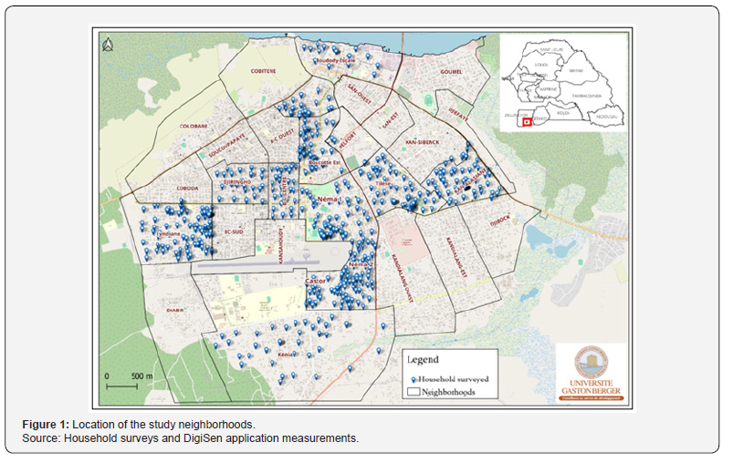
By shedding light on these issues, the article proposes a renewed reading of the urban digital divide, understood not as an isolated technical deficit, but as a complex socio-territorial construction at the intersection of infrastructure, practices, informal economies, and institutional choices (Figure 1).
Methodology
The study adopts a mixed-methods approach combining social, territorial, and technical data in order to capture the multidimensional nature of the digital divide. This triangulation makes it possible to cross-analyze the actual quality of connectivity, youth digital practices, and the structure of the informal ecosystem. Data processing was carried out using Excel 2024, SPSS v.29, Python (Pandas), and QGIS 3.34 (UTM projection 28N).
General approach
The methodology is structured around three complementary components : i) a socio-geographical survey among young people, enabling the observation of practices, skills, and perceptions of connectivity; ii) a geolocated inventory of informal digital services, considered a key social infrastructure for everyday access to digital resources; iii) technical measurements derived from the DigiSen system, providing objective and independent data on the actual performance of mobile and Wi-Fi networks.
This analytical architecture makes it possible to move beyond approaches focused exclusively on access or skills, in order to deliver a territorially grounded interpretation of the digital divide.
The “Youth and Digital” survey
The survey was conducted among 566 young people aged 18 to 24 across ten neighborhoods representative of the urban diversity of Ziguinchor. The questionnaire, administered via KoboCollect, includes 538 variables grouped into six modules: sociodemographic profile, digital equipment and access conditions, digital skills and literacy, uses and purposes, perception of connectivity, and institutional expectations.
Sampling was stratified by gender (48% female; 52% male) and residential location in order to capture intra-urban variations.
Inventory of informal digital services
A comprehensive census of 556 units was conducted: mobile money kiosks (OM/WAVE), transfer points, cybercafés, computer workshops, reprography services, repair shops, and accessory sales outlets. Each unit was characterized according to its type of service, functional diversity, level of equipment, and GPS location.
This database makes it possible to analyze the density and spatial organization of the informal ecosystem, whose role is decisive in everyday digital access.
Technical measurements - DigiSen system
The third component consists of data generated by the DigiSen application. It is based on a participatory approach involving more than 150 youth volunteers who installed the application on their smartphones. Over a 45-day period, these volunteers carried out repeated measurements during their daily movements and activities. This process generated more than 14,180 geolocated points, forming an unprecedented technical dataset in Ziguinchor.
Each data point includes: operator (Orange, Free), network generation (3G/4G), download speed (Mb/s), upload speed (Mb/s), latency (ms), type of connectivity (mobile/Wi-Fi), GPS coordinates, and timestamp.
These measurements provide an independent and fine-grained evaluation of the actual quality of connectivity, allowing a direct comparison between perceptions and observed performance.
Data integration and analysis
The integration of the three components enabled:
i. the construction of composite indicators (mobile quality,
functional diversity, digital capabilities);
ii. statistical correlations (Spearman);
iii. cross-analyses (neighborhood × connectivity × uses ×
services);
iv. the production of thematic maps visualizing the spatial
distribution of speeds, services, and practices.
This methodology provides a territorial, multi-actor, and multi-level reading of the digital divide within the city.
Results
The combined analysis of DigiSen technical measurements, youth digital practices, and the structure of informal services reveals a digital divide that is simultaneously infrastructural, social, and territorial. The results show that network quality, intensity of use, and the density of proximity services are structured along a clear urban hierarchy opposing highperforming central areas to more fragile peripheral zones. The analysis relies on composite indicators (mobile quality, digital capabilities, functional diversity), Spearman correlations, and cross-analyses (neighborhood × connectivity × uses × services), complemented by spatial representations of speeds, service density, and capabilities.
Technical performance of connectivity: a centerperiphery gradient
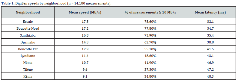
DigiSen measurements reveal a very clear differentiation in network quality between central neighborhoods and peripheral areas (Table 1). In central neighborhoods (Escale, Boucotte Nord, Santhiaba), nearly four out of five measurements exceed 10 Mb/s (between 73.9% and 78.6%), compared with only about one-third in Kénia (34.8%) and slightly more than one-third in Tilène (37.3%). In practical terms, the probability of having a “comfortable” connection (≥ 10 Mb/s) is more than twice as high in central areas as in the periphery.
The gap in mean speed between Escale (17.5 Mb/s) and Kénia (9.1 Mb/s) reaches +92.3%, while latency increases by more than 50% between Escale (32.1 ms) and Kénia (48.3 ms). These contrasts confirm the existence of a digitally polarized infrastructure where central neighborhoods benefit from structurally more favorable service quality.
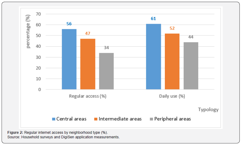
This structuring effect is also reflected in the Youth survey. More than half of young people living in central neighborhoods (56%) report regular internet access, compared with only onethird in peripheral areas (34%), a difference of 22 percentage points. Similarly, daily use concerns nearly two-thirds of young people in central areas (61%), but fewer than half in peripheral neighborhoods (44%) (Figure 2).
The Spearman correlation between the average DigiSen speed and declared regular access is high (ρ = +0.52; p < 0.01), indicating that the better the measured connectivity in a neighborhood, the higher the proportion of young people reporting regular access. The digital divide is therefore primarily driven by the unequal territorial distribution of technical performance.
Digital capabilities and uses among young people : a divide of opportunities
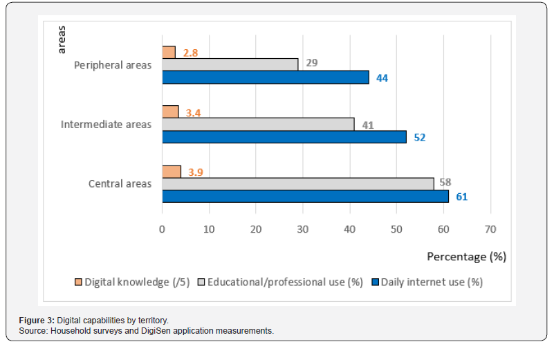
The data show that differences in connectivity translate into differences in digital capabilities, understood as the capacity to convert connection into educational, professional, or civic opportunities. In central neighborhoods, 6 out of 10 young people (61%) connect daily, compared with fewer than one in two in peripheral areas (44%). The gap is even more pronounced for educational or professional uses : 58% of young people in central areas use the internet for learning or work, compared with 29% in peripheral neighborhoods, a ratio of 1 to 2.
Self-assessed digital knowledge follows the same spatial logic. The average score decreases from 3.9/5 in central areas to 2.8/5 in peripheral zones, representing a relative decline of about 28%. The correlation between digital knowledge and educational use is positive and significant (ρ = +0.47; p < 0.01), showing that the digital divide is not only a matter of network access, but also of skills and educational capital.
Even at comparable levels of education, young people living in poorly connected neighborhoods report more frequent abandonment of online courses, difficulties downloading resources, and problems participating in videoconferences. Territory therefore acts as an additional filter shaping capabilities and opportunities (Figure 3).
Informal digital services: density, diversity, and social infrastructures
The inventory of 556 informal digital service units shows that the informal digital economy represents a decisive social infrastructure, yet it is also very unevenly distributed across the urban space.
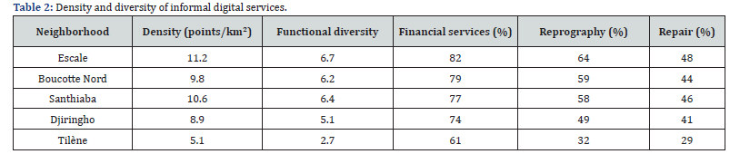
In Escale, density reaches 11.2 service points per km², more than double that of Tilène (5.1 points per km²). In practical terms, a young person living in the city center has twice the probability of having a digital service point within immediate proximity compared with a young person living in the periphery.
Functional diversity follows the same pattern. It declines from an average of 6.7 types of services in Escale (payments, transfers, reprography, assistance, maintenance, accessory sales) to 2.7 in Tilène, representing a reduction of 60%. In central neighborhoods, more than 80% of units offer financial services, nearly two-thirds provide reprography services (64% in Escale), and almost one out of two ensures repair services (48%). In Tilène, these proportions drop respectively to 61%, 32%, and 29% (Table 2).
The Spearman correlation between functional diversity and average DigiSen speed is significant (ρ = +0.41; p < 0.05). In practical terms, the broader the range of services available in a neighborhood, the higher the average quality of connectivity. This suggests a digital agglomeration effect: neighborhoods where networks function well attract more services, and these services in turn reinforce digital appropriation.
Integrated territorial typology: connectivity, uses, and services
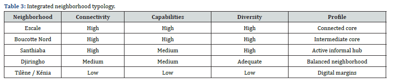
By combining indicators of mobile quality (DigiSen), digital capabilities, and functional diversity of services, it is possible to identify a synthetic territorial typology of the city (Table 3).
Source: Household surveys and DigiSen application measurements.
Source: Household surveys and DigiSen application measurements.
Source: Household surveys and DigiSen application measurements.
Central cores (Escale, Boucotte Nord, Santhiaba) concentrate the three main advantages: speeds above the city average, more frequent daily and educational uses, and particularly high densities and diversities of informal services. Conversely, Tilène and Kénia constitute true digital margins, characterized by significantly lower speeds, much lower participation in educational uses, and sharply reduced service diversity.
Between these two extremes, Djiringho, Lyndiane, and Boucotte Est display intermediate profiles where opportunities are increasing but remain strongly dependent on proximity to central areas.
Overall, the results confirm that the digital divide in Ziguinchor is neither purely technical nor strictly social. It results from the overlapping of territorial determinants where residential location simultaneously shapes network quality, the presence of proximity services, and the ability of young people to transform these resources into real opportunities.
Discussion
The results obtained in Ziguinchor confirm that the digital divide in secondary African cities cannot be reduced to a mere deficit of infrastructure. Rather, it reflects a multidimensional system of inequalities where technical performance, residential location, individual capabilities, and the functional density of proximity-based digital services interact. This finding is consistent with the analyses of Van Dijk [7] and Helsper [8], for whom contemporary digital divides are less about the distinction between the connected and the unconnected than about the capacity of individuals to transform access into social resources, and the structural constraints that prevent them from doing so.
The patterns observed strongly corroborate the results obtained by Sow et al. [9] in Saint-Louis, which highlight a highly differentiated intra-urban geography of youth digital practices. As in Saint-Louis, Ziguinchor exhibits a marked centerperiphery structure where central neighborhoods combine better connectivity, a richer supply of proximity services, and more intensive educational uses. However, thanks to more than 14,180 DigiSen measurements collected by 150 volunteers, this study provides an unprecedented level of resolution regarding the actual quality of network performance at the micro-territorial scale. The variations observed, ranging from 8 to 34 Mb/s depending on neighborhoods and operators, reveal disparities far greater than those suggested by national statistics or operator-reported data.
These findings are methodologically aligned with the work of Seye, Mbaye, Diallo, Ndiaye, Sow, Adjanohoun, Mbengue, Wade, De Roulet, Munyaka, and Chenal [10], which demonstrates the relevance of participatory walk test approaches for capturing real mobile network performance in African cities. In Ziguinchor, the scope and granularity of the DigiSen system reinforce this approach by combining technical measurements, geolocation of informal services, and youth digital practices within a single integrated framework.
One of the major contributions of the study lies in the empirical demonstration of the structuring role of the informal ecosystem. Previous work by De Roulet and colleagues in Saint-Louis had already shown that electronic shops, telecenters, and micro digital services function as genuine social infrastructures in secondary cities. In Ziguinchor, this hypothesis is confirmed and refined. The diversity of informal services is positively correlated with network quality (ρ = +0.41), and the best-served neighborhoods are also those with the highest functional density.
Contrary to observations made in the metropolitan areas of Nairobi, Johannesburg, and Cape Town [11-13], where informal services often compensate for infrastructural deficiencies in peripheral areas, in Ziguinchor they tend instead to reinforce existing centralities. Digital informality, rather than mitigating inequalities, contributes to consolidating territorial advantages. This configuration constitutes one of the key theoretical contributions of this research.
The results also show that young people’s digital capabilities are deeply conditioned by residential location, and not solely by education level. Even at equivalent educational attainment, young people living in peripheral neighborhoods more frequently report abandoning online learning activities due to insufficient speeds, unstable connections, or prohibitive costs. This observation supports Sen’s capability approach applied to the digital realm: capabilities are always situated and depend on a set of material, social, and territorial conditions.
The study empirically demonstrates this territorialization of digital capabilities through the triangulation of surveys, mapping, and technical measurements. This integrated demonstration goes beyond earlier findings by Helsper and Reisdorf [8] and expands upon previous work by Sow et al. in Saint-Louis by providing a more robust statistical and spatial dimension.
The dynamics observed in Ziguinchor converge with a broad international literature. In Kenya and South Africa, Gillwald and Moyo [11] and Research ICT Africa [12] show that connectivity quality is closely linked to residential status and the ability of households to locate in well-served areas. In India, studies conducted in Bangalore [14] and Hyderabad [15] reveal similar fractures between technological districts, middle-class areas, and peripheral zones. In Latin America, in cities such as São Paulo [16], Mexico City [17], and Lima [18], the overlap between digital and socio-spatial inequalities is systematically observed [19-24].
However, Ziguinchor presents three notable specificities. First, a near-total dependence on the informal digital economy, unlike metropolitan areas where public telecenters and municipal infrastructures are more developed. Second, a particularly pronounced center-periphery polarization despite the modest size of the city. Third, the integration of a participatory observatory, DigiSen, providing fine-grained data rarely available in secondary cities of the Global South.
These elements make Ziguinchor an original case in digital geography, demonstrating that digital inequalities may be more intense in intermediate cities than in some better-equipped metropolitan areas.
By articulating three empirical datasets - a survey of 566 young people, a geolocated inventory of 556 informal digital service units, and more than 14,180 participatory technical measurements - this study proposes an innovative methodological approach in West Africa. It offers a theoretical contribution on the territorialization of digital capabilities, a major empirical contribution to understanding informal digital economies, a methodological advance by demonstrating the robustness of participatory high-resolution data systems, and an operational contribution by providing local governments with a precise and actionable intra-urban diagnostic.
In this sense, Ziguinchor becomes a particularly relevant case study for understanding how infrastructures, knowledge, informality, and territory jointly produce the digital divide in secondary African cities.
Conclusion
The digital trajectory of Ziguinchor shows that secondary African cities can no longer be analyzed solely through national indicators of internet coverage or penetration. By combining three complementary datasets - a survey of 566 young people, a geolocated inventory of 556 informal services, and more than 14,180 DigiSen measurements - this study reveals a deeply territorialized digital divide in which technical, social, and socioeconomic disparities overlap.
The city appears as a privileged field for understanding how residential location continues to structure digital opportunities. Despite a relatively high level of equipment ownership (67.5% smartphone possession), only 42.8% of young people report regular access to high-quality internet, and this share drops to 34% in peripheral neighborhoods.
One of the major strengths of this work lies in its ability to quantify the magnitude of the center-periphery gradient. Central neighborhoods record average speeds between 17 and 18 Mb/s, with more than 78% of measurements exceeding the 10 Mb/s threshold, whereas peripheral areas fall below 10 Mb/s, with barely 35% of measurements above this critical level. These technical gaps directly translate into differences in digital capabilities. Educational uses decline from 58% in central areas to 29% in peripheral zones, and self-assessed digital knowledge drops from 3.9/5 to 2.8/5, representing a relative decrease of nearly 28%. Similarly, daily internet use decreases from 61% in central areas to 44% in the periphery. These figures confirm that infrastructure alone does not guarantee digital inclusion. The real dividing line lies in the ability of individuals to convert connectivity into opportunities.
One of the major scientific contributions of this research lies in highlighting the structuring role of the informal digital ecosystem. While some studies in South Africa and Kenya suggest that informal services compensate for infrastructural deficits in peripheral areas, the results observed in Ziguinchor point in the opposite direction. Service density reaches 11.2 points per km² in Escale compared to 5.1 in Tilène, while functional diversity declines from 6.7 service types to 2.7, representing a reduction of more than 60%. The positive correlation between service diversity and network speed (ρ = +0.41) indicates that well-connected neighborhoods attract more services, reinforcing a cumulative dynamic of digital centrality. Rather than reducing disparities, the informal economy contributes to crystallizing the advantages of urban central areas.
From a theoretical perspective, this study contributes to the field of African digital geography by demonstrating that the digital divide is neither purely infrastructural nor purely social. It is a socio-territorial construction shaped by the interaction of measured technical performance, digital literacy, financial capacity, local informality, and proximity to urban centralities. Linking digital capabilities with intra-urban geography renews the analytical framework for understanding digital inequalities in West Africa.
From a methodological standpoint, the integration of a highresolution participatory observatory, based on more than 14,180 measurements collected by 150 volunteers, constitutes a major innovation for documenting the actual quality of networks. In Senegal and across Africa, very few secondary cities benefit from such detailed diagnostics, making these findings particularly valuable for both geographical research and public policy.
For Senegal, where national strategies such as Sénégal Numérique 2025 and the New Technological Deal aim to accelerate digital transformation, the results call for a reorientation of policies toward an infra-urban reading of inequalities. The 22-point difference in regular access between central areas (56%) and peripheral zones (34%), as well as the latency levels nearly 50% higher in Kénia than in Escale, show that national averages mask deep local vulnerabilities. The challenge therefore becomes the construction of a form of geo-digital justice, involving targeted investments in digital margins, stronger support for proximity services in underserved neighborhoods, and the structured integration of the informal economy as a key actor in the digital transition.
Finally, this study opens several research perspectives: extending the analysis to other age groups, conducting longitudinal monitoring of technical performance, and carrying out systematic comparisons with other Senegalese cities such as Saint-Louis, Kaolack, and Tambacounda in order to develop a national typology of digital divides.
Ultimately, Ziguinchor emerges as an exemplary observatory of the contemporary tensions shaping secondary African cities. It is a connected city marked by intense digital discontinuities, where informality, capabilities, and geography combine to produce a deeply unequal digital landscape. By making these disparities visible with unprecedented precision, this research contributes to repositioning digital issues at the core of urban geography and as a strategic lever for reducing territorial vulnerabilities in Senegal and across Africa.
References
- Gillwald A (2022) Digital inclusion and structural inequalities in Africa. Information Technology for Development 28(4): 675-693.
- Helsper EJ (2021) The digital disconnect: The social causes and consequences of digital inequality. London: SAGE Publications, p. 278.
- Sen A (1999) Development as freedom. Oxford: Oxford University Press.
- ADIE (Agence de l’Informatique de l’État) (2023) Annual report on digital infrastructure in Senegal. Dakar: ADIE, p. 78.
- Data Reportal, We Are Social, Meltwater (2024) Digital 2024, Senegal, p. 92.
- ANSD (Agence Nationale de la Statistique et de la Démographie) (2025) National statistical report. Dakar: ANSD, p. 112.
- Van Dijk J (2020) The digital divide: Inequality in the information society (3rd), London: SAGE Publications, p. 312.
- Helsper EJ, Reisdorf B (2021) Emerging divides across digital engagement: A capability-based model. New Media & Society 23(5): 1204-1225.
- Sow D, Adjanohoun DS, Mbengue TDP, Wade CS, Seye MR, et al. (2025) Digital inclusion and youth participation in urban governance in Sub-Saharan Africa: The case of Saint-Louis, Senegal. Global Journal for Research Analysis 14(1).
- Seye MR, Mbaye D, Diallo M, Ndiaye ML, Sow D, et al. (2025) A crowdsourcing-based walk test approach to evaluate mobile network quality. IEEE International Conference on Consumer Electronics (ICCE 2025), Las Vegas, pp. 1-6.
- Gillwald A, Moyo M (2018) After Access 2018: A demand-side view of mobile internet use in Africa. Research ICT Africa, p. 118.
- Research ICT Africa (2019) Digital inequality in Africa: A geospatial perspective. RIA Publications, p. 74.
- Mothobi O, Chair C (2021) Mobile internet quality and inequality in African cities. Research ICT Africa Working Paper, p. 52.
- Gupta A, Madon S (2020) Digital urbanisms in Bangalore: Networks, inequality and opportunity. Information, Communication & Society 23(6): 849-867.
- Kumar V, Ananth S, Singh R (2021) Urban internet geographies and mobile dependence in Hyderabad. Telecommunications Policy 45(10).
- De Souza R, García M (2020) Urban digital divide in São Paulo: Infrastructure, markets and inequalities. Journal of Urban Technology 27(3): 43-62.
- Aguilar A, Tovar C, Sánchez L (2019) Digital inequalities in Mexico City. Urban Studies 56(14): 2995-3014.
- Fernández-maldonado AM (2021) Informal digital practices and urban inequality in Lima. Cities 108: 102971.
- Adjanohoun DS, Mbengue TDP, Sow D, Wade CS, Seye MR, et al. (2025) The digital policies in the face of access and usage inequalities among young people in intermediate cities in Senegal: The case of Saint-Louis. Journal of Infrastructure, Policy and Development 9(1): 10899.
- De Roulet P, Chenal J, Munyaka Baraka JC, Diallo M, Mbaye D, et al. (2024) Electronics shops in Saint-Louis: A participative mapping of value, quality, and prices within the market hierarchy in a secondary Senegalese city. p. 38.
- Graham M (2023) Digital geographies and uneven connectivity in the Global South. Geoforum 137: 41-52.
- Jaglin S, Sagna O (2022) Urban services and digital inequalities in African cities. Autrepart 101(1): 87-104.
- UNESCO (2022) Digital skills for all: Global framework for inclusive digital literacy. Paris: UNESCO Publishing, p. 152.
- UNESCO Broadband Commission (2022) State of broadband 2022. Paris: UNESCO, p. 138.