Benthic Biocenoses Formation and Distribution (Caspian Sea)
Kirill Petrov*
Institute of Earth Sciences, Saint Petersburg State University, Russia
Submission: September 09, 2019; Published: September 24, 2019
*Corresponding author: Kirill Petrov, Institute of Earth Sciences, Saint Petersburg State University, Russia
How to cite this article: Kirill Petrov. Benthic Biocenoses Formation and Distribution (Caspian Sea). JOJ Wildl Biodivers. 2019: 1(3): 555565. DOI: 10.19080/JOJWB.2019.01.555565
Mini review
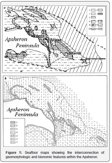
The leading role of geological and geomorphological elements in the formation of different types of benthic communities of the continental shelf is discussed. Recent tectonic processes control the nature of coastal seafloor relief and, the composition and distribution of bottom sediments. Tectonic uplift resulted in the construction of extensive shallows of the Apsheron Archipelago, the Caspian Sea (Figure. 1a). [1]а - Geomorphological map. Legend: 1 - accumulative (depositional) plains, 2 - abrasion-accumulative (erosional-depositional) plains, 3 - nearshore accumulative (depositional) areas, 4 - abrasion (erosional) ridges, 5 -lower shelf accumulative (deeper, non-wave depositional) plains, 6 - coastal sand ramparts, 7 - sand bars, 8 - mud volcanoes, 9 - seaward extension of the Greater Caucasus mega-anticlinorium, 10 - seafloor expression of active anticlinal uplift, 11 - inverted landforms confined to local synclines. b - Bionomic map. Legend: 1 - abrasion-sculptural (eroded-scoured) features with sessile benthos, 2 - plains covered with lithified crust containing, communities of red algae, Mytilaster and Balanus communities, 3 - coastal ramparts, 4 - sandy-shell plains with nektobenthonic communities of Isopoda, Amphipod, Cumacea, 5 - muddy-sand plains with sea grass community at depths of 2-5 m, 6 - muddy plains with community of pelophilic infauna Cerastoderma lamarcki, Abra ovata, Pyrgula, Nereis diversicolor, Oligochaeta, Hypania at depths greater than 10-15m, 7 - muddy plains with Dreissena rostriformis community at depths of 15-20 m.
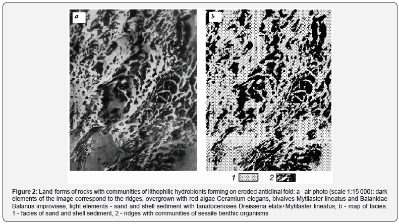
Two basic types of natural bottom complexes are identified that exhibit characteristic - habitats and communities of aquatic organisms. One such complex consists of bedrock outcrops (Figure 1b, symbol 1). The other is a cover of sand-shell sediments on the abrasion plain (Figure. 1b, symbol 4). Natural bottom complexes form a system of horizontal and vertical morphological units [2]. The use of aerial photography for integrated study and mapping of the seabed in shallow water is shown (Figure 2) [1]. The important role of space data and methodology in these studies is also noted.


Additional information on the biodiversity of the Phyto benthos of the Apsheron Archipelago is presented in the paper [3].
References
- Gur’eva ZI, Petrov KM, Sharkov VV (1976) Aerophotomethods geological and geomorphological studies of the inner shelf and coasts of the seas. Atlas of annotated aerial photographs. Leningrad: Nedra, Russia.
- Petrov KM (1989) Underwater landscapes: theory, research methods. Leningrad: Nauka, Russia.
- Petrov KM (2018) Phytobentos as an indicator of the water area of the Absheron archipelago Caspian Sea. Advances in Biology & Earth Sciences 3(2): 140-151.


