




 IJESNR Home



Abstract
This research paper employs the SBAS InSAR technique to comprehensively analyze surface deformation along the Ghazi-i-Millat Road (GMR), revealing deformation rates ranging from -14.50mm/year to +15mm/year. Notably, significant movements are concentrated between -11mm/year and +15mm/year, while an observed uplift rate of 17.07mm/year strongly indicates ongoing landslide activity. Inherent topographical features and dynamic slope conditions predominantly influence these deformations. Landslide susceptibility mapping identifies critical risk parameters, including slope gradient, slope aspect, soil moisture content, and vegetation cover. However, it is essential to emphasize that in regions characterized by dense vegetation, the SBAS-derived deformation estimates suffer from pronounced decorrelation effects, thereby reducing the reliability and precision of the results in these specific areas. Advancing the current state of geotechnical research, this investigation integrates a replicable AHP-GIS framework for landslide risk assessment, offering an innovative approach to evaluating and mitigating geohazards. The weighted overlay analysis underscores the paramount influence of slope gradient on landslide susceptibility, while illuminating the complex interplay among environmental variables. These findings underscore the urgent need for proactive disaster management strategies, including structural interventions and targeted vegetation restoration measures. Such strategies are essential for safeguarding critical infrastructure and promoting sustainable land management practices in regions susceptible to landslide hazards. This work establishes a new benchmark for deformation monitoring and risk evaluation by combining advanced InSAR methodologies with robust GIS analytical tools. The study contributes valuable insights into the mechanics of landslide phenomena and paves the way for future research to refine monitoring techniques in challenging environments. Ultimately, the innovative integration of multi-disciplinary approaches presented herein holds significant promise for enhancing geohazard mitigation efforts on a global scale. These robust outcomes invite further investigation into enhanced data fusion techniques and comprehensive interdisciplinary risk analysis frameworks.
Keywords: Small Baseline Synthetic Aperture Radar (SBAS); Analytic Hierarchy Process (AHP); Ghazi-Millat Road (GMR); Landslides
Introduction
Landslides are among the most pervasive natural hazards globally, particularly in mountainous and hilly regions [1]. These phenomena often result in significant socio-economic disruptions, environmental degradation, and loss of life [2]. Given the complex interplay of geological, hydrological, and anthropogenic factors that contribute to landslide occurrences, identifying landslide-prone zones has become critical research focus Wang & Nanehkaran [3]. In recent years, advanced geospatial technologies have proven to be powerful tools for assessing and predicting landslide susceptibility, aiding in developing mitigation strategies to minimize damage [4]. The Ghazi-i-Millat Road, an economic corridor stretching from Rawalakot to Azad Pattan in Azad Kashmir, is a vital transportation artery for local communities and regional commerce [5]. This corridor traverses rugged and geologically unstable terrain, making it highly susceptible to landslides, particularly during the monsoon season and periods of seismic activity [6]. Frequent landslide events disrupt transportation and trade and threaten nearby populations' safety and the integrity of critical infrastructure [7]. Understanding the spatial distribution of landslide susceptibility along this corridor is paramount for long-term sustainable development and disaster risk reduction [8].
Recent advances in Synthetic Aperture Radar (SAR) remote sensing technologies, particularly the Small Baseline Subset Interferometric Synthetic Aperture Radar (SBAS-InSAR) technique, have revolutionized the field of geohazard monitoring [9]. SBAS-InSAR allows for the precise detection of ground deformation over time, enabling researchers to map landslide-prone areas with high accuracy, even in regions with dense vegetation and cloud cover—limitations that often hinder optical remote sensing methods [10]. By leveraging the SBAS-InSAR approach, this study aims to provide a comprehensive geospatial analysis of ground deformation along the Ghazi-i-Millat Economic Corridor, identifying zones with elevated landslide susceptibility.
In addition to SBAS-InSAR, the Analytic Hierarchy Process (AHP) is employed in this study to enhance landslide susceptibility assessment. AHP is a multi-criteria decision-making (MCDM) method that systematically evaluates various factors contributing to landslides, such as slope gradient, soil type, land use, and rainfall patterns [11]. By integrating AHP with SBAS-InSAR, this study introduces a novel approach to landslide susceptibility mapping that quantifies ground deformation and considers the relative importance of landslide-triggering factors.
The objective of this research is twofold. First, it seeks to delineate high-risk landslide zones along the Ghazi-i-Millat Road using SBAS-InSAR and AHP methodologies. Second, it aims to offer a decision-support framework for local governments and infrastructure planners to prioritize mitigation efforts, enhance road safety, and promote sustainable development in this economically strategic corridor. Given the reliance of regional economies on the uninterrupted functioning of transportation networks, such an assessment is crucial for reducing landslide-induced disruptions and ensuring resilience in the face of climate change and other environmental pressures.
This study fills a critical gap in the existing body of landslide research by employing an integrated SBAS-InSAR and AHP approach. While numerous studies have focused on landslide susceptibility mapping in various regions, few have combined high-precision remote sensing techniques with MCDM methods in the context of economically vital corridors such as the Ghazi-i-Millat Road. This research, therefore, offers both methodological advancements and practical insights for landslide risk management, with implications for broader applications in other geologically unstable regions.
Study Area
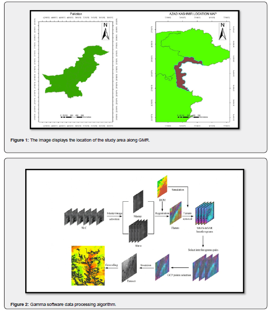
The study area is within the Rawalakot district of Azad Jammu and Kashmir (AJK), a region renowned for its rugged terrain and scenic landscapes in northern Pakistan. Specifically, the research focuses on the Ghoin Valley, a geographically significant area that straddles the Ghazi-i-Millat Road (GMR) a critical economic corridor linking Rawalakot to Azad Pattan.
This corridor traverses a challenging environment with steep slopes and sharp elevation changes, making it highly susceptible to landslides and ground instabilities [12]. The topography of the study area is predominantly mountainous and hilly, marked by sharp ridgelines, road cuts, escarpments, and active debris flows [13]. These features contribute to the region's natural beauty and present significant infrastructure development and safety challenges [14]. The steep slopes and road cuts along the GMR are particularly prone to landslide events, which threaten the stability of the road and the surrounding environment [15]. The complex interplay of geological formations and frequent heavy rainfall during the monsoon season further exacerbates the area's susceptibility to landslides, making it a critical zone for geospatial and risk analysis [16]. Strategically located, the GMR is a key artery for transportation, economic trade, and regional connectivity between Pakistan and Azad Kashmir. However, its geological instability necessitates continuous monitoring and management to prevent landslide-induced disruptions. This study aims to comprehensively analyze the landslide susceptibility in this vital corridor, offering insights that will contribute to safer infrastructure planning and long-term resilience. Wadia investigated the geology of the headmost study area [17]. In the study area, lithostratigraphic units are exposed from Miocene to Pliocene rocks succession and recently exposed alluvium in the Sub-Himalayas laterally the eastern limb of Hazara Kashmir Syntaxis (HKS) [18]. Chinji Formation of the late Miocene age, Kamlial Formation of the late Miocene age, and Murree Formation of the early Miocene age are documented in the study area (Figure 1).
Methodology
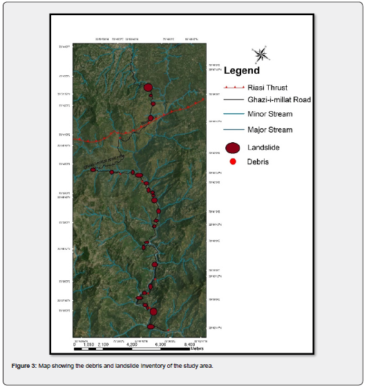
This study utilizes an integrated approach combining SBAS-InSAR and the AHP to assess landslide susceptibility along the GMR in the Ghoin Valley, Rawalakot district, Azad Jammu and Kashmir. The methodological framework is designed to accurately identify, quantify, and map landslide-prone zones in a mountainous region known for its complex topography and geological instability. The following steps outline the methodological approach adopted in this research and is shown in Figure 2.
SBAS-InSAR analysis for ground displacement detection
To detect and map ground displacement along the Great Migration Road (GMR) in the Ghoin Valley, we apply the Small Baseline Subset - Interferometric Synthetic Aperture Radar (SBAS-InSAR) technique [19], utilizing Sentinel-1 SAR data and the GAMMA software suite. This approach enables precise monitoring of surface deformations over time. The processing workflow, illustrated in the accompanying diagram, involves the following stages:
Data preparation and preprocessing: Single Look Complex (SLC) Data Collection: We collected 91 SLC images from Sentinel-1 SAR acquisitions, which capture radar backscatter signals to represent the surface characteristics of the Ghoin Valley over multiple periods. SAR Imagery: Sentinel-1 satellite SAR data covering the study area from January 2021 to December 2023 were acquired for the SBAS-InSAR analysis. This data was used to detect ground deformation and subtle changes in terrain, providing insight into potential landslide-prone zones. Toal 91 Sentinl-1 images are used for performing SBAS in Gamma software.
Topographic maps and DEM: The Shuttle Radar Topography Mission (SRTM) sourced a digital elevation model (DEM) [20] with a resolution of 30 meters to model slope gradients [21] and elevation profiles, critical factors in landslide susceptibility. Preprocessing involves Master Image Selection: From this stack of SLC images, we select one master image as the primary reference for comparisons with the remaining images (slave images).
Image registration: Using a Digital Elevation Model (DEM), we registered each slave image to the master image to ensure all images share a consistent spatial reference. This registration corrects minor geometric distortions that may arise from satellite movement or topographic variations.
Simulation and terrain flattening: Simulation and DEM-Based Terrain Removal: We removed terrain effects using the DEM to produce flattened interferograms, effectively isolating deformation signals from natural terrain variations. This step reduces the influence of topography, making ground displacement signals more visible.
Interferogram generation: SBAS-InSAR Interferogram Production: We generated 546 interferograms from the preprocessed images. Each interferogram represents the phase difference between pairs of SLC images, corresponding to relative ground displacement across observation periods.
Interferogram pair selection: We selected specific interferogram pairs with minimal spatial and temporal baselines to reduce decorrelation and improve sensitivity to subtle ground movements. The SBAS technique ensures that these interferograms accurately reflect long-term deformation trends.
Ground control point (GCP) selection and inversion: Ground Control Point (GCP) Selection: We identify Ground Control Points (GCPs), stable locations on the ground with known coordinates, to anchor the displacement calculations with precise reference points.
Phase inversion: We then invert the phase information from the selected interferograms to calculate displacement values at each GCP over time. This step translates phase differences into measurable displacements, allowing us to quantify surface movement across the study area.
Displacement mapping and geocoding: We georeference the displacement data, aligning the results with geographic coordinates for accurate spatial mapping. Final Displacement Map Creation: We visualize the processed data in a displacement map, highlighting zones of significant ground deformation. Regions with persistent or accelerating displacement are classified as high-risk zones, indicating potential landslide-prone areas.
To complement the SBAS-InSAR analysis, the AHP method was used to evaluate multiple landslide-triggering factors in a multi-criteria decision-making framework. The steps involved in AHP are as follows:
a) Thematic Layers: Sentinel-2 collects geospatial layers, including slope, aspect, geology, drainage pattern, NDVI, and NDWI, to form the input for the AHP analysis.
b) Selection of Criteria: Key factors influencing landslide susceptibility were selected based on literature review and expert consultation. These include slope, aspect, geology, proximity to drainage, NDVI, and NDWI.
c) Pairwise Comparison: A pairwise comparison matrix is constructed, assigning relative weights to each criterion based on its influence on landslide occurrence. Expert judgment and past studies were referenced to ensure the accuracy of weight assignments.
d) Weighted Overlay Analysis: The weights from the AHP process are applied to the thematic layers, creating a landslide susceptibility index (LSI) for the study area. This index categorizes the region into low, medium, and high susceptibility zones based on the combined influence of all factors.
The landslide susceptibility map generated from the AHP is validated using ground truth data and historical landslide records from the study area [22]. Field visits verify the accuracy of identified landslide-prone zones, ensuring that the model effectively captures real-world conditions.
The results from both SBAS-InSAR and AHP are integrated into a comprehensive geospatial landslide susceptibility map [23]. The final maps provide a detailed visual representation of ground deformation trends and high-risk zones along the GMR in the Ghoin Valley. The map is developed using ArcGIS and other geospatial tools, with clear demarcations of low, medium, and high susceptibility zones. The final susceptibility map is crucial for local authorities, infrastructure planners, and policymakers. By identifying the most vulnerable sections of the GMR, the study provides a decision-support framework for mitigation planning, prioritizing slope stabilization, drainage improvements, and road safety measures. The results also contribute to developing early warning systems, which can help reduce the risk of landslide-induced road closures and accidents.
Landslide Inventory
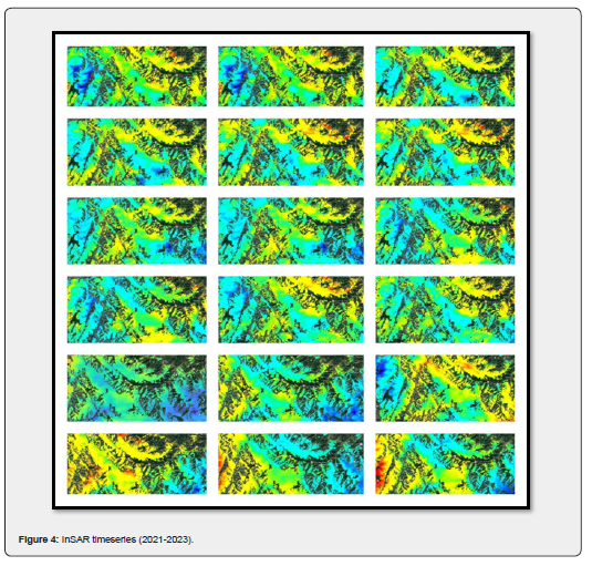
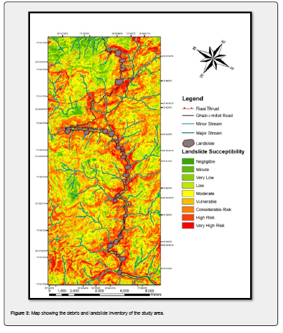
The landslide inventory is an assemblage of data that incorporates knowledge of landslides' location, activity, type, and physical characteristics [24]. The landslide inventory is heavily affected by the sort and class of accessible information. The landslide inventory of the study area prepared in the GIS develops a foundation for determining the landslide hazard along the GMR. However, the Google Earth data-based landslide inventory provides realistically detailed, accurate information and visual interpretation [25]. The advantage of using Google Earth data is that it enables semi-automated landslide detection based on morphological parameters of mapped landslides [26]. Further, this research focused on automatized landslide mapping, the criteria of landslide inventory, and then the susceptibility map along the GMR. The Landslide inventory map was prepared using GIS (Figure 3). This landslide inventory map is critical in determining the location of all the landslides and debris flows along the GMR in the Poonch, Azad Kashmir district. Its primary focus is on the significant geomorphological elements influencing slope stability. Twenty-eight active landslides and twelve debris flows are marked on the inventory map and are confirmed during multiple field GPS-based field surveys, as shown in Figure 3.
Results
Figure 4
SBAS-InSAR results
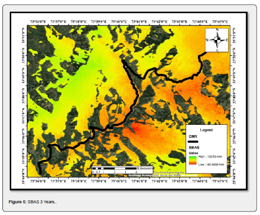
The Surface Deformation Rate along the Line of Sight (LOS) direction is calculated using SAR data and analyzed with the SBAS InSAR technique. A deformation threshold of 0.3mm/year was applied. Positive LOS deformation values indicate surface movement toward the satellite sensor, while negative values represent deformation directed away from the sensor. The observed deformation rate across the GMR is a maximum of 130mm and a minimum -of 96mm for the three years, particularly within the Ghoin Valley and adjacent regions flanking the GMR. The LOS-measured deformation deviates from actual surface displacement patterns due to topographic effects. Notably, high deformation concentrations are predominantly along the slope aspect of the GMR, exhibiting substantial ground motion on the steep slope bodies. This distribution aligns closely with the spatial pattern of LOS deformation points. However, the deformation rate along the slope direction exhibits greater magnitude than the LOS direction, underscoring the influence of slope dynamics on surface instability. These results suggest that the observed deformations reflect significant geomorphological processes in the study area, with notable variations driven by topographical influences and slope-specific stresses (Figure 5).
Susceptibility mapping
The susceptibility mapping was initiated by preparing an inventory map of 28 landslides along the GMR in the study area. The landslide inventory map facilitated considering the distinctive causative elements that control various slope movements. GPS field survey determines the active, recent, and old landslides along the GMR. The topographic factors, elevation, and slope gradient along the slope aspect are derived out of the Digital Elevation Model (DEM), Normalized Differentiated Water Index (NDWI), and Normalized Differentiated Vegetation Index (NDVI) are obtained from the Sentinel hub. The analytic Hierarchy Process (AHP) technique prepares a landslide susceptibility map along the Ghazi-i-Millat road. The weighted Overlay tool is applied to overlay analysis using AHP. The Weighted Overlay tool lets us implement distinct steps in a single tool's general overlay analysis process. Weighted Overlay tool follows these steps as:
a) Reclassifies standards involving raster into a mutual assessment scale of appropriateness, preference, hazard, or some corresponding scales.
b) Multiplies the cell standards individually input raster by raster's weight importance.
c) Adds subsequent cell standards composed to yield output raster.
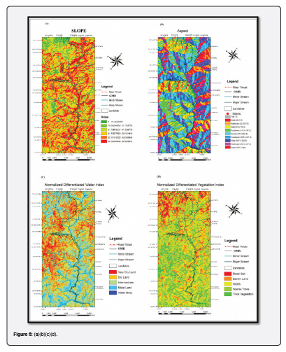
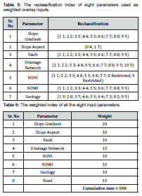
Weighted Overlay proceeds single integer rasters as input, so rasters of slope gradient, slope aspect, NDVI, NDWI, lithology, drainage network, fault, and road are reclassified into integers before they are used. Then, all selected input rasters are allotted a weight percentage based on importance. The total influence for all raster’s is equal to 100 %. Then, the Weighted Overlay technique is applied. Then, as a result, a susceptibility analysis map of landslides in the study area along the GMR was obtained (Figure 6).
Slope
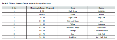
The most accessible element is the effect of slope steepness on landsliding. Steeper inclines usually have greater coincidental land sliding. Geomorphological features and topographic configurations significantly influence the stability of slopes in terms of both surface erosion and the gravitational movements of the earth's material. The slope gradient map of the study area is prepared in GIS using the Digital Elevation Model (DEM) of the study area. The slope gradient map of the study area is shown in Figure 6. The slope gradient map's slope angle values are derived in degrees and divided into nine classes to illustrate the landslide hazard potential due to the slope gradient along the GMR. The division of six courses of slope gradient is given in Table 1. The GMR lies in the high-risk and very high-risk zone, and some of the roads lie in a vulnerable zone.
Slope aspect
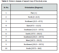
The Slope Aspect indirectly affects the exposure to light, breeze, and rain, thus incidentally distressing other elements that aid in landslides, such as vegetation cover, soil wetness, and soil width. The aspect map prepared for the study area is branched into ten classes and illustrated in Table 2. Twenty-eight landslides are found in east—and southeast-facing orientation; others lie in the remaining courses. The aspect map is also a result of DEM and is prepared in GIS (Figure 6).
NDWI
Normalized Differentiated Water Index (NDWI) is used to analyze the moisture framework of the study area. The index utilizes Green and near-infra-red bands of remote sensing images. The NDWI efficiently enhances the moisture information of the study area in the present research work and the preparation of the landslide susceptibility map. It is sensitive to promote land, which results in escalated water bodies. Water bodies have low reflectance. It only reflects within the visible portion of the electromagnetic spectrum. Water bodies in their liquid state generally have higher reflectance on the Blue (0.4 - 0.5µm) spectrum than Green (0.5 -0.6µm) and Red (0.6 – 0.7µm) spectra clear water with the most prominent reflection in the visible spectrum in the blue section. So, water appears blue. Turbid water has a higher visible reflectivity spectrum. There is no reflection in Near Infrared (NIR) and beyond. Gao designed NDWI to improve the water characteristics of the landscapes (Gao, 1996). This index practices immediate infrared (NIR) and Short-Wave infrared (SWIR) bands. NDWI is calculated using the following formula:

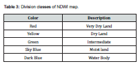
NDWI is obtained from sentinel hub 2-A 14-band imagery and displayed in Figure 6. It is classified into five classes: arid land, dry land, intermediate, moist land, and water body. According to the NDWI map prepared for the study area, the GMR lies in the moist land-to-water body classes.Furthermore, the landslides marked on the inventory lie in the same classes (Table 3).
NDVI
Normalized Difference Vegetation Index (NDVI) calibrates shrubbery by calculating the difference between near-infrared (which shrubbery greatly reflects) and red-light shrubbery absorbs).NDVI regularly varies from -1 to +1. However, there is no separate frontier for each land cover. While we get negative values, it will be water, and there is no doubt about this. On the other hand, there is an excellent possibility that there are dense green leaves if we obtain an NDVI value close to +1; if there are no green leaves, there may be domestic land, barren land, or rock, or only soil cover when the NDVI value is close to zero. NDVI uses the NIR and red channels in its formula:

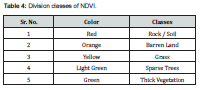
Healthy vegetation (chlorophyll) reflects near-infrared (NIR) and green light more than other wavelengths. Red and blue light are further absorbed. For this reason, our eyes see plants as green. If we could see near-infrared, it would also be vital for vegetation. The NDVI is obtained from sentinel hub 2-A 14-band imagery. It is displayed in Figure 6. The NDVI is divided into five classes, represented by different colors, as illustrated in Table 4.
Landslide susceptibility map
Landslide vulnerability is studied along GMR by applying the weighted overlay technique using a Geographic Information System (GIS). It has been developed using eight causative parameters. These parameters include slope gradient, slope aspect, NDVI, NDWI, drainage network, road, fault, and geology. All eight parameters are assigned a specific weight after reclassification in GIS. The reclassification of eight parameters is shown in Table 5. The weighted index of all eight parameters is illustrated in Table 6. The cumulative sum of all the eight weights is equal to a hundred. The slope gradient has been assigned a maximum weight of 20 out of hundred because it is recognized as the primary cause of landslides during field surveys. Then, a weighted overlay tool is run, which, as a result, provides us with a landslide susceptibility map. The derived landslide susceptibility map of the study is divided into nine classes: negligible, minute, very low, low, moderate, vulnerable, considerable risk, high risk, and very high risk. In the present research work, our primary focus was on landslide hazard analysis along the GMR, so it is observed in the landslide susceptibility map that all the landslides marked along the road lie in the three classes that are considerable risk, high risk, and very high risk.
The landslide susceptibility map indicates that the road constructed is susceptible to slope failures. The landslides along the road are road cuts triggered by rainwater penetration in the existing material, high slope gradients, same slope aspect, different vegetation index, different water index, and loose lithology. Three rock formations are recorded in the study area. Chinji formation, Kamlial formation, and Murree formation. All three formations contain dominantly sandstone and clays in different ratios. Clays are porous and contain absorption abilities and swelling properties, so as a result of precipitation, they absorb water. Due to high slope angles along the road, they tend to fail the slopes, resulting in landslides blocking the highway and causing damage to the road and remedial measures such as parapet walls and bioengineering, etc. This results in a loss of cost for repairing roads and delay in economic activities of the affected area. The landslide susceptibility map is displayed in Figure 7.
Discussion
The Surface Deformation Rate along the Line of Sight (LOS) direction is calculated using SAR data and analyzed with the SBAS InSAR technique. A deformation threshold of 0.3mm/year was applied. Positive LOS deformation values indicate surface movement toward the satellite sensor, while negative values represent deformation directed away from the sensor. The observed deformation rate across the GMR ranged from -14.50mm/year to +15mm/year, with significant deformation primarily concentrated between -11 and 15mm/year, particularly within the Ghoin Valley and adjacent regions flanking the GMR. The LOS-measured deformation deviates from actual surface displacement patterns due to topographic effects. Specifically, an uplift rate of 17.07mm/year is detected along the GMR, indicative of ongoing landslide activity. Notably, high deformation concentrations are predominantly along the slope aspect of the GMR, exhibiting substantial ground motion on the steep slope bodies. This distribution aligns closely with the spatial pattern of LOS deformation points. However, the deformation rate along the slope direction exhibits greater magnitude than the LOS direction, underscoring the influence of slope dynamics on surface instability. These results suggest that the observed deformations reflect significant geomorphological processes in the study area, with notable variations driven by topographical influences and slope-specific stresses.
The landslide susceptibility mapping along the Ghazi-i-Millat Road (GMR) highlights the significant impact of factors like slope gradient, slope aspect, soil moisture (NDWI), and vegetation cover (NDVI) on landslide occurrences. The study revealed that steep slopes, particularly those facing east and southeast, are more prone to landslides, with high-risk areas marked by reduced vegetation and high soil moisture levels, which decrease slope stability. The weighted overlay analysis, using the Analytic Hierarchy Process (AHP) in a GIS framework, assigned the highest weight to slope gradient (20%), underscoring its critical role in landslide susceptibility, followed by drainage networks and proximity to roads (15% each), which exacerbate erosion and soil weakening due to water infiltration and road cuts. Zones near fault lines and drainage networks were identified as particularly vulnerable due to seismic activity and groundwater flow, intensifying erosion. The susceptibility map effectively stratified risk levels along the GMR, designating many sections as high or very high risk, indicating a need for immediate interventions like retaining walls, improved drainage, and vegetation restoration. This integrative AHP-GIS model offers a replicable approach to landslide risk assessment, providing vital insights for proactive disaster management and infrastructure protection in similarly susceptible regions.
Conclusion
This study has effectively demonstrated the application of the SBAS InSAR technique for assessing surface deformation along the Ghazi-i-Millat Road (GMR), yielding critical insights into the geomorphological processes shaping this complex region. Our analysis revealed a notable range of deformation rates, extending from -14.50mm/year to +15mm/year, with mainly concentrated movements observed between -11mm/year and +15mm/year. The detected uplift rate of 17.07mm/year is of special significance, which unequivocally indicates active landslide processes and underscores the pressing need for continuous monitoring and timely intervention in these vulnerable sectors. Integrating SBAS InSAR with advanced landslide susceptibility mapping has enabled us to construct a detailed spatial framework that identifies the key factors influencing slope stability. Our study has highlighted critical determinants of landslide risk, including slope gradient, slope aspect, soil moisture, and vegetation cover. The weighted overlay analysis, which prioritized slope gradient as a dominant factor, reinforces its pivotal role in controlling landslide susceptibility. Such nuanced insights into the interrelationships among geomorphological variables enhance our understanding of the local deformation dynamics and provide a robust basis for predictive modeling in similar geological settings. Likewise, this investigation's innovative use of an integrative AHP-GIS framework represents a significant advancement in geohazard assessment. This methodological synergy has proven replicable and scalable, offering a versatile tool for comprehensive risk evaluation that can be adapted to other regions characterized by complex terrain and active deformation. The framework's capacity to incorporate multi-criteria analysis ensures that all relevant factors are systematically considered, thereby improving the reliability and interpretability of landslide susceptibility models. The outcomes of this research have profound implications for infrastructure protection and sustainable land management in landslide-prone areas. By pinpointing zones of critical deformation and identifying the primary drivers of instability, our study furnishes decision-makers with actionable intelligence that can inform the design and implementation of targeted disaster management strategies. Structural interventions, such as the construction of retaining walls and the enhancement of drainage systems, coupled with strategic vegetation restoration, are recommended to mitigate landslide risks effectively. These proactive measures, informed by our detailed geospatial analysis, safeguard the region's infrastructural assets and ensure long-term community resilience. Besides, this study's scientific rigor and methodological innovations contribute to the broader geohazard monitoring and risk mitigation discourse. The findings not only advance the current understanding of landslide dynamics along the GMR but also lay the groundwork for future investigations to refine remote sensing techniques and enhance data fusion approaches. In doing so, this research offers a blueprint for integrating high-resolution deformation monitoring with multi-criteria risk assessment, ultimately fostering more effective strategies for disaster preparedness and sustainable land management. The present work is a testament to the power of advanced remote sensing and geospatial analysis in elucidating complex geomorphological phenomena. The insights derived from our study are poised to influence both academic research and practical applications in disaster risk reduction, marking a significant contribution to the scientific community and offering a strategic pathway for mitigating the adverse impacts of landslide hazards.
Recommendation
A multifaceted, scientifically grounded strategy is imperative to effectively mitigate the pronounced landslide risks along the Ghazi-i-Millat Road (GMR). First, we recommend establishing continuous monitoring systems that integrate InSAR and ground-based sensors for real-time tracking of surface deformation. This dual-modality approach will facilitate the early detection of anomalous movements and enhance overall situational awareness, enabling prompt and effective intervention. Targeted engineering interventions should be implemented to bolster slope stability. Specifically, constructing retaining walls and deploying advanced drainage systems are essential to manage excess water and reduce destabilizing forces. In light of the observed limitations of SBAS InSAR in densely vegetated areas—where decorrelation effects impair measurement accuracy—it is advisable to integrate supplementary monitoring techniques, ensuring a robust and reliable data framework. Additionally, comprehensive vegetation restoration programs should be prioritized in high-risk zones. Restoring native vegetation stabilizes slopes and contributes to broader ecological resilience. Concurrently, public awareness initiatives are crucial to educating local communities on landslide risks and emergency preparedness, enhancing overall community resilience. Regular updates of landslide susceptibility maps and integrated land-use planning in collaboration with local authorities will ensure adaptive and dynamic risk management. Such proactive measures will help maintain the relevance of risk assessments in the face of evolving environmental conditions. Finally, further research into the interplay of slope stability factors is essential to refine predictive models and enhance the scientific basis for risk mitigation strategies. These recommendations offer a comprehensive, interdisciplinary approach to reducing landslide hazards along the GMR, ultimately fostering sustainable land management and safeguarding critical infrastructure.
Funding Information
No organization funds this work; all the data is obtained from accessible sources.
Acknowledgment
I thank Sentinel-1 and Sentinel-2 for providing the data for processing, calculating the deformation rate, and identifying the landslide-susceptible zones. This support was immense throughout the research process and significantly contributed to completing this paper on "Deciphering the Impact of Vegetation on SBAS-InSAR Efficacy: Insights from Landslide Susceptibility Mapping Along the Ghazi-i-Millat Corridor."
References
- Seçkin Fidan, Hakan Tanyaş, Abdullah Akbaş, Lombardo L, Petley DN, et al. (2024) Understanding fatal landslides at global scales: a summary of topographic, climatic, and anthropogenic perspectives. Natural Hazards 120: 6437-6455.
- Kumar P (2024) Social and Economic Impact in the Landslide Prone Zones and Related Policies. Disaster Risk Reduction, pp. 499-529.
- Wang Y, Nanehkaran YA (2024) GIS-based fuzzy logic technique for mapping landslide susceptibility analyzing in a coastal soft rock zone. Natural Hazards 120: 10889-10921.
- Agboola G, Leila Hashemi Beni, Tamer Elbayoumi, Thompson G (2024) Optimizing landslide susceptibility mapping using machine learning and geospatial techniques. Ecological Informatics 81: 102583-102583.
- Bilal M, Xing A, Hazarika H (2024) The Chinese loess plateau, earthquakes, and flowslides: the need to enhance geotechnical disaster resilience. Landslides 22: 591-596.
- Rathore HA, Niaz A, Farooq M, Khan MY, Syed Ali Turab, et al. (2024) Geophysical and geotechnical characterization of Lower Sudhan Gali Landslide (LSGL), Bagh Azad Jammu & Kashmir. Geomatics Natural Hazards and Risk 15(1).
- Alcántara-Ayala I (2025) Landslides in a changing world. Landslides 22: 2851-2865.
- Yadawa SK (2024) Landslide Mitigation and Sustainable Management and Policies. Disaster Risk Reduction, pp. 423-447.
- Nwodo GO, Okeke FI, Nduji NN (2023) Application of Interferometric Synthetic Aperture Radar (InSAR) Technique in Monitoring the Deformation of Large Oil Storage Tanks. World Journal of Research and Review 15(6): 18-25.
- Guo H, Yuan Y, Wang J, Cui J, Zhang D, et al. (2023) Large-Scale Land Subsidence Monitoring and Prediction Based on SBAS-InSAR Technology with Time-Series Sentinel-1A Satellite Data. Remote Sensing 15(11): 2843.
- Mao Y, Zhu L, Chen J, Nanehkaran YA (2024) Adaptive Modeling of Landslide Susceptibility Using Analytical Hierarchy Process and Multi-Objective Decision Optimization. Advances in Space Research 75(6): 4536-4551.
- Momburi LT, Li C, Masami FNM, Ren M, Otoo I (2024) Study of Flooding Behavior and Discharge from Karot Dam in the Event of a Possible Breach by Using the Hydrodynamic Model. Water 16(20): 2922.
- Bojer AK, Ahmed ME, Bekalo DJ, Debelee TG, Al-Quraishi AMF, etal. (2023). Analysis of land use/land cover change (LULCC) and debris flow risks in Adama district, Ethiopia, aided by numerical simulation and deep learning-based remote sensing. Stochastic Environmental Research and Risk Assessment, 37(12): 4893-4910.
- Morar C, Lukić T, Basarin B, Valjarević A, Vujičić M, et al. (2021) Shaping Sustainable Urban Environments by Addressing the Hydro-Meteorological Factors in Landslide Occurrence: Ciuperca Hill (Oradea, Romania). International Journal of Environmental Research and Public Health 18(9): 5022.
- Gardezi SAH, Usmani NA, Chen X, Ikram N, Ahmad S, et al. (2022) Application of data‐driven techniques for landslide susceptibility prediction along an earthquake‐affected road section in Kashmir Himalaya. Geological Journal 58(2): 849-882.
- Rehman A, Sajjad M, Song J, Riaz MT, Mehmood MS, et al. (2024) Integrated frequency ratio-analytical hierarchy and geospatial techniques-based earthquake risk assessment in mountainous cities: a case from the Northwestern Himalayas. Georisk Assessment and Management of Risk for Engineered Systems and Geohazards 19(2): 389-409.
- Khan M, Khan R, Shams Ul Islam, Khan A, Zhong Y, et al. (2024) Provenance, diagenesis, and depositional environment of miocene Kamlial Formation, Azad Kashmir, Sub Himalayas, Pakistan: Evidences from field observations and petrography. Heliyon 10(2): e24309.
- Zubair RA, Long X, Baig MS (2022) Structural geometry, kinematics and paleostress of the Main Boundary Thrust: New constraints from the Hazara-Kashmir syntaxis, Northwest Himalayas, Pakistan. Journal of Asian Earth Sciences 228: 105129.
- Cai J, Ming D, Liu F, Ling X, Liu N, et al. (2025) Change detection of slow-moving landslide with multi-source SBAS-InSAR and Light-U2Net. International Journal of Applied Earth Observation and Geoinformation 136: 104387.
- Roy S, Uddin MG, Abdelrahman K, Fnais MS, Abioui M (2024) Assessing the impact of digital elevation model resolution on hypsometric analysis in large river Basins (India): a non-parametric statistical approach. Earth Science Informatics 18(1).
- Lian Q, Chen L, Dang X, Zhuo W, Li C (2024) Dynamic response and fragility of mountain bridges under the coupled effects of transverse earthquakes and landslides. Soil Dynamics and Earthquake Engineering 188: 109079.
- Abolmasov B (2025) Progress in Landslide Research and Technology 3(2): 2024. Springer Nature.
- Shan B, Qi J, Tian W, Zhu K, Jin T, et al. (2025) Early Identification of Geological Hazards Along the Power Transmission Line in Weinan Based on SBAS-InSAR. Applied Sciences 15(2): 920.
- Qiu H, Wei Y (2025) Landslide Geomorphology: Pattern, Process and Stability. Journal of Earth Science 36(1): 327-332.
- Karantanellis E, Hölbling D (2024) Machine learning and object-based image analysis for landside mapping using UAV-derived data. Elsevier EBooks, pp. 241-255.
- Khadka D, Zhang J, Sharma A (2025) Geographic object-based image analysis for landslide identification using machine learning on google earth engine. Environmental Earth Sciences 84(92).