Abstract
Development of geosystems in Pacific Russia occur against the background of increased seismicity and are most clearly manifested with the participation of continentality (K; mainly winter) and oceanicity (O; due to monsoons) with the manifestation of catastrophes and the corresponding spectrum of anomalous phenomena:
a. In the area of prevailing continentality, dry winds, fires, frost cracking, kurum formation, rockfalls, screes, etc. are characteristic;
b. In the area of prevailing oceanicity - typhoons, showers, floods, storms and storm surges, tsunamis, mudflows, landslides and landslides, erosive washouts, avalanches and others.
At maximum values of various K or O, the most intense anomalous phenomena are observed, and at minimum values, relatively less intense ones are observed. Original ways of determining these characteristics at the continental and regional levels are proposed.
Keywords: Pacific Russia; Anomalous processes; Disasters; Continentality; Oceanicity
Introduction
General theoretical concepts: terms and concepts
Pacific Russia is represented as a set of terrestrial geo(eco-) systems in the Pacific mobile belt (tectonically and climatically active zone of contact between the continent and the ocean, i.e. island and marginal-continental land) in various morphotectonic and macroclimatic sectors of the Pacific megaecotone of Northern Eurasia [1]. This contradictory influence on geosystems (GS) is extremely strong [2]. It manifests itself directly or indirectly through the atmosphere, i.e. through the unique Far Eastern climates. The latter are characterized by the following:
a) The great importance of circulation factors in their formation;
b) The dominant role of oceanic influence in the warm period of the year, when the summer monsoon operates, and continental influence in the cold period, when the monsoon circulation is superimposed on the western transfer of air masses.
c) Sharp and multidirectional (intra- and interseasonal, annual, perennial, secular rhythms, etc.) and multifaceted (regional, local, altitudinal belt) contrasts of heat and moisture against a sharply expressed wind background. During interaction between continentality (K) and oceanicity (O), special biometric energetic prerequisites are ultimately created for the development of specific GS and, at the same time, geomorphological landscapes - a kind of regulator of the stability of general geosystems. As a result of climate impact on geosystems (GS), a complex set of interacting and complementary exogenous processes arises – typical and abnormal (extreme critical and crisis, as well as catastrophic).
For an adequate understanding of the results of the study conducted by the author, it is appropriate to provide an interpretation of the terms used.
The Complex Physical-Geographic Envelope (CPGE) and the Geographical Envelope (GE) - are externally integral formations, but composite within. It is characterized by vertical and horizontal heterogeneity (a complex of private envelopes – natural territorial and aquatic complexes). The structure of the geographic envelope was formed during its evolution. In this case, vertical differentiation (into geospheres) is caused, first by the division of matter, and horizontal differentiation (into natural-territorial complexes) is associated with spatial changes in energy [3-5].
Geographical space (GS) - is a form of existence of natural objects and phenomena within the complex physical-geographical envelope (CPGE), characterized by a set of relationships between them (structure, system, dynamism, metric properties), located in a specific territory and developing in time [6,7]. It is assumed that this space is multidimensional.
Space - territory (S-T). A certain paradox can be seen in their comparison. They are externally close in many ways, but internally heterogeneous. Their main difference is in their unequal dimensionality - space is always 3-dimensional and without boundaries, and territory is 2-dimensional and with boundaries.
Geographical time (GT) - arises with the emergence of special geographical systems, the main components of which are elements of the hydrosphere and troposphere and relief forms, as carriers of the geographical form of matter movement [8]. This time is uneven [6], which is confirmed by the concept of glaciation metachrony. Thus, in the Northern and Southern hemispheres of the Earth, the time intervals between the same states are uneven, but in the North they are compressed, and in the South they are stretched.
The properties of time are generated by matter itself in various interactions. They are as follows:
a) Absolute - in relation to the development of relief as geological [9];
b) Relative - the sequence of events (in relation to the development of relief, its stages) [10];
c) Characteristic - the duration of the functioning of objects, from their origin to complete destruction.
Physical properties of time Space and Time are inseparable, since each time has its own space, and each space its own time, understanding them together under the term "timespace", that is, "time-space" [11,12]. The last represents the reality generated by the current social development and inherent in the current social analysis.
According to the causal mechanics of N.A. Kozyrev, time, in addition to the passive property of duration, is also characterized by active (physical) properties that affect events in geographic space. The active properties of time are manifested in cause-and-effect relationships and are reflected in the counteraction to the usual course of processes leading to the destruction of the GS. Since it is scattered in space, the possibility of its accumulation is realized (for example, in living organisms) and, thus, supports the unification of the World into a single whole. Thus, time is the organizing principle in Nature and the source of its vital possibilities [13].
Geosystems (GS) are accepted in an understanding close to the definition of V.B. Sochava [11,14]. These are terrestrial spaces of all dimensions (from topographic geosystems to CFGO), developing with the manifestation of self-regulation and where individual components of nature are in a systemic connection with each other, and as a certain integrity interacts with the cosmic sphere and human society [2].
Development (D) is an irreversible, directed, lawful change of objects (a universal property of "space-time"), manifested in 2 forms (evolutionary and "catastrophic"), possessing ascending and descending segments of its trajectory, and always leading to the emergence of a new qualitative state [2].
Stability of geosystems (SGS) is understood by us as the ability, on the one hand, to preserve their structure and functioning in the mode of normal natural rhythms in a changing external environment, and on the other hand, to maintain reciprocating development under conditions of abnormal impacts, which creates the basis for their plasticity. At the same time, stability does not mean absolute stability and assumes fluctuations around the average state, i.e. dynamic equilibrium of systems [15].
Sustainable development of geosystems (SDGS) is possible with the balance of its main components (exploitation of natural resources, ecological balance, orientation of scientific and technological development, etc.), consistent with each other and with the future potential for satisfying human needs and aspirations. Thus, it is characterized by three main principles - social, economic and ecological. Let us recall that this term was introduced into circulation back in 1987 in the report Our Common Future, prepared by the World Commission of the United Nations (UN) on Environment and Development. It stated that global environmental crises are interconnected and their solution requires comprehensive solutions oriented towards sustainable development.
The author accepts the following categories, characterized by a certain expanded content:
a) Continentality (K) is a set of properties of general and component territorial GS, caused not only by the location factor, but also by the active joint impact of polygenic land on system-forming processes within the complex physical-geographical envelope (CPGE).
b) Oceanicity (O) is a set of properties of general and component aquatic GS, caused not only by the location factor, but also by the active joint impact of polygenic water mass on system-forming processes within the CPGE [2].
In the usual narrowed understanding, "Continentality of climate" is a set of climate properties caused by the impact of the land surface on climate formation processes, and the opposite "oceanicity of climate" is the result of the ocean's impact on climate.
c) Typical processes (TP) are those whose intensity fluctuates within the limits typical for a given territory, controlled by biometeorological energy within the framework of seasonal and, partly, long-term rhythms of landscapes of a specific region; their impact on the GS is manifested in dynamics, without changing the type of functioning. Extreme (critical and crisis) processes (EP) cause an acceptable maximum or minimum deviation from the norm of a particular factor indicator, which is unusual for a given place and is reflected in the course of the GS development (floods, avalanches, etc.). At the same time, extreme critical processes lead to a significant but short-term change in the GS structure, which is often reversible, but requires a significant period of time for relaxation; extreme crisis processes (extremely rarely reversible, more often irreversible) are generally comparable in their impact to catastrophic ones [2,15].
d) Catastrophic processes (CP) are sudden, leading to complete or partially significant destruction of the main system-organizing components of the GS. All stages of disasters are characterized by contrast (different time preparation of extreme situations - increase and "summation" of the effects of critical states - crisis "explosions").
Catastrophism is accepted by the author, following D.A. Timofeev, as a revolutionary development of the GS, which is expressed in the unevenness (catastrophicity) of the manifestation of endogenous and exogenous forces in time and space. It includes not only the destruction of previously formed structures and types of functioning of the GS, but also the creation of adequately new dynamic formations. This is also in accordance with the views of the great scientist and thinker M.V. Lomonosov, who showed that "nothing comes from nothing, and nothing disappears without a trace." Indeed, according to the law of conservation of energy - if somewhere it has increased, then somewhere it has decreased [16]. The general background of catastrophism in the Far East is characterized by increased tension, increasing in the region from North to South [7,17-19].
"Natural risks" is a general concept and is applicable only to Man, i.e. its content always includes the ecological aspect, indicating all deviations from the spectrum of material and energy indicators that are optimal for natural components, human life and economic activity. This is close to the accepted formulations [20].
Risks arise, develop and "manifest" themselves in natural and (or) anthropogenic environments and conditions - as a result of the functioning of a certain complex of system-forming factors and processes: typical (in particular, due to the cumulative effect of their impacts) and extreme (critical and crisis). It is their various impacts and interactions that predetermine certain levels of possible "natural risks" for Man.
"Environmental risks" is a general concept and is more often applicable to natural landscapes [19,21]. This understanding resonates with the theory of the so-called "self-organized criticality", according to which systems with a large number of interacting components naturally evolve to a critical (crisis) state [22].
Nature management (natural resource management) is the use of natural resources in the process of economic activity in order to achieve a certain economic effect [23].
Prerequisites for the author's analysis
In solving the goal and objectives of the proposed article, the framework of the author's analysis was outlined by the territorial boundaries of the North and South of Pacific Russia. The main results of the analysis are presented below.
In all natural zones of the territory under consideration, a very wide range of exogenous processes is observed (from typical to extreme – critical and crisis, and catastrophic).
The evolution of typical processes is complicated by “bursts” of criticality, crisis and then “explosions” of catastrophism. It reveals a decrease in the number of state changes (with the dominance of equilibrium ones), enhancing the natural stability of the GS in inland areas, and their increase in coastal areas stimulates an increase in the number and scale of natural anomalies, leading to a decrease in the overall stability of the GS there [22]. Consequently, the evolutionary spiral of the GS is both complex and contradictory. Within the Pacific Russia, it manifests itself in the following framework:
a) From the general to the particular (from vertical heterogeneity of the GS to horizontal) [2,8];
b) From simple to complex (for example, such as, a ravine - a gully - a river system; horizontal and gently sloping, slightly mobile surfaces - steep slopes with gravitational, avalanche collapse of various blocks of rocks; slow hydrothermal movements in soils - active frost cracks causing the formation of polygons; madallions, stone rings - polygonal systems of fissure-vein ice; isolated thermokarst depressions - extensive thermokarst failures and systems of thermokarst lakes; etc.). As a result - on the remains of the destroyed, something new appears with traces of the old;
c) From equilibrium states of the GS to non-equilibrium ones (in particular, evolutionary changes in development are replaced by extreme explosions, when, for example, the normal flow of rivers turns into sharp floods; disequilibrium in systems arising from the onset of different temperatures is replaced by an equilibrium state that spontaneously occurs after the relaxation of the former). Ultimately, the evolutionary development of the GS gradually or contrastingly turns into a crisis and then into a catastrophic one [24];
d) In the generality of "similarity - opposite" states of the GS (transitions and mutual transitions against the background of thermosity to cryosity or from xerosity to hygrosity, and in extreme cases from xerothermosity to hygrocryosity or xerocryosity to hygrothermosity; etc.). As a result, evolutionary development is contrastingly combined with crisis and catastrophic;
e) In a complex combination of certainty and uncertainty. Typical situations are more characterized by certainties, while anomalous (critical and crisis) and catastrophic situations are more often characterized by uncertainties. And the higher the energy levels of these situations (in the direction from typical to anomalous – critical and crisis, and catastrophic), the more clearly these patterns are manifested. Management of any uncertainties is most constructive from the side of catastrophic factors, as they have greater potential for this. As a result, the self-development of the GS at this stage becomes more definite [22];
f) In the indicated variants of the development of the GS, such a pattern always manifests itself – if creation in it has ceased, then the destruction of the primary inevitably begins with the creation of a more complex new one, and vice versa. Thus, a total result arises in the form of complex mutual transitions of the evolutionary and anomalous trinity creating a new picture of the natural world;
g) The distinctive features of the regional development of the GS are additionally determined by the location factor, for example, similar in terms of heat supply and different in terms of moisture, etc. Thus, polar GS, occupying a special place among the main types of landscapes of the Earth, are classified as cold, xerocryos and hygrocryos [25]. At the same time, their entire development occurs more often against a background of increased wind. The development of the GS in the South of the region occurs in other natural and climatic conditions, energetically significantly more intense - warm and contrasting in humidity, xerothermic and hygrothermic.
Among the general characteristic properties in the anomalous development of the GS, within the regional natural zones (from the North to the South), an expanding spectrum and an increase in the intensity of anomalous destructive and constructive contrasts can be traced, with the concentration of their extreme states within the island arcs and megacoasts [26]. This is explained by the directed increase in hydrothermodynamic tension, simultaneously illustrated by the spatial picture of the increasing effects of continentality (K) and oceanicity (O).
An increase in the natural continentality of the climate causes an increase in the relief formation of anomalous processes and catastrophes [27].
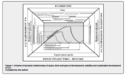
Threshold situations of mutual transitions of various processes ("typical - critical", "critical - crisis") or unidirectional transitions ("crisis - catastrophic") are identified with various states of the GS [26]. In this case, during the change of the GS, dynamic stages of development are distinguished (Figure 1):
a) Calm progressive, stage-cyclic, with typical processes;
b) Reciprocating, under the influence of critical processes;
c) Intermittent progressive, with the leading contribution of crisis processes;
d) Dynamically explosive and destructive, with the dominance of catastrophism.
Thus, the paradox of the development of the GS is that their functioning within the Pacific Russia is subject not only to objective natural laws and anthropogenic patterns, but also "takes place" according to the principle of uncontrolled accidents (in our case, these are criticality, crisis and catastrophism), subject only to the highest logic of Being. At the same time, the adoption of illogical decisions leads to a certain result. Achieving with its help an optimal natural background ensures the implementation of compatibility of the physical and moral in rational nature management.
Preliminary conclusions on the current state of natural disasters
The spectrum of natural disasters in Pacific Russia is distinguished by great diversity, but at the same time by clear territorial confinement.
In the North, Chukotka and Primagadan, these are primarily thermokarst subsidences of different scales that are significant in the development of GS. Thus, against the background of possible global warming in combination with regional cooling, thermokarst fluctuations occur. The latter appear in the summer in the form of successively alternating catastrophic "bursts" and attenuations. In particular, during rare but intense precipitation brought by "breakthroughs" of deep cyclones, a sharp "deepening" of the horizon of seasonal freezing-thawing occurs. This leads to an abrupt increase in its thickness and the rapid appearance of thermokarst depressions and sinkholes.
In general, “explosions” of cryogenesis activity and (or) “minor” glaciogenesis (frost cracking, solifluction, formation of fissure-vein polygons and thermokarst formations) are significant here.
In Kamchatka, during periods of increased volcanic activity, rapid magma outpourings destroy large adjacent areas of vegetation and upper soil horizons. Large ashfalls significantly damage tree plantations and destroy natural grass cover and agricultural crops over vast adjacent areas.
In coastal areas of marginal seas, during periods of increased seismic activity, high waves are generated, causing devastating damage to the GS (seismic collapses, "cleaning" of the coast during the removal of coastal soil differences to the underwater slope, etc.).
In the South of the territory, during the arrival of deep cyclones from the west and powerful typhoons from the south, bringing huge volumes of atmospheric moisture, catastrophic floods occur. The latter cover all floodplain areas and lower terrace levels in river valleys, destroying agricultural lands, industrial facilities and civil buildings. Dry winds in the steppe zone of Primorye, during rare "protracted" anticyclonic states of hot weather, destroy natural grassy vegetation and agricultural crops.
Materials and Methods
The work uses the data of the author's long-term geomorphological and geoecological studies in Chukotka and Wrangel Island (1957-1959, 1971-1972); in the Kolyma River basin and in Priokhotye (1971-1972, 1974-1975); in the lowlands (1974-1979), in the mountains, coastal areas and on the islands of the southern Far East (2007-2018); materials of year-round meteorological observations of the author during his "Polar Wintering" (Rogers Bay sea station, Wrangel Island, 1957-1959); as well as available literary and fund sources.
The methods used are comparative-geographical, geophysical, and informational.
Results and Discussion
Pacific Russia, as noted above, is located in a steadily active transition-contact zone of two of the Earth's greatest structures (the Asian continent and the oceans - the Arctic and Pacific with their seas), which, during their interaction, exert a powerful system-forming influence within the temperate, subarctic, and arctic natural-climatic zones.
Over a larger area of the territory, this is manifested in the directed continentalization of the natural environment; in the differentiated distribution of solid atmospheric precipitation (relatively small in the North and increased in the South); high "wind stress" in winter, when snow, in particular on the islands, is intensively blown into the sea, etc.
In its northern regions, the modern development of the GS is determined and controlled primarily by the specific polar and subpolar climate (in the area of high meteorological and geocryological risk). In the south of the Russian Far East, the interactions between the continent and the ocean in their contact zone from the Mesozoic to the present day are manifested unevenly both by season and by territory. They are revealed through the monsoon circulation of air masses generated by them - continental in winter and oceanic in summer. The interactions of continental and oceanic influences in the late Pleistocene and Holocene were most pronounced in the zone from 380 to 540 N, which was expressed in the displacement of the boundaries of natural zones and the maximum contrast of temperature and moisture indicators [2].
Natural situations against the background of global warming
Global warming has affected the structure of the GS. The soil temperature in the Arctic (from 2007 to 2017) increased by 0.5°C [28,29]. At the same time, permafrost processes and the "hydrology" of the territory have intensified. In addition, against the background of increased thermokarst, permafrost degradation occurred. Predicting the future structure of the geosystem is complicated by the emergence of feedbacks [2] provoked by climate and environmental transformations.
Indeed, global warming has caused various transformations of geosystems. But not everywhere. Melting icebergs can slow down global warming. In addition, there are areas where warming has "slowed down" and is no longer occurring. Thus, in the North Atlantic there is an area where the Gulf Stream and its heat transfer have decreased, which is why a local decrease in air temperature is observed [28].
Climate change has been tracked by a number of researchers [29,30].
Here, the maximum warming was noted in the 1970-1980s, after which it began to decline to the present. Thus, based on the comparative situation "with the events of two completed cycles of solar activity," it cannot be said that there will be a continuation of high warming here [31, p. 129]. This is also indicated by the reduction in the size of thermokarst lakes in Chukotka, which indicates a slowdown in the destruction of permafrost (according to aerospace materials).
Data from a number of meteorological stations in Eastern Chukotka (Kolyuchino, Nettan, Uelen, Dezhnev Post, Ratmanova, Lavrentiya, Provideniya, Chaplin Mys), starting in the 1970s, show a steady increase in air temperature, but starting in 2010 this increase slowed down and stopped in a number of places.
The conclusions of international experts also confirm the beginning of a regional cooling of the climate in the North [29]. The cooling, along with a decrease in thermokarst activity in Chukotka, is also indicated by the activation of frost cracking.
The beginning of a cooling is also characteristic of the South of the Far East. The emerging further strengthening of the natural continentality of the climate [32] predetermines a directed increase in the role of dangerous natural processes in relief formation, and the increase in contrasts between continental and oceanic influences leads to the extreme nature of natural processes.
Thus, according to our data, cooling is observed throughout the entire territory of the Russian Far East [33].
Dynamic trends, levels of organization and stability of the GS
Anomalous processes were active until the middle of the Holocene. This is evidenced by their traced area expansion (forest fires about 5.5 thousand, 2.8 thousand, 1.87 thousand, 0.5 thousand years ago – in the basin of the rivers Samarga, Edinka, Partizanskaya, Kievka and others), storm surges (about 4.7 thousand, 2.4 thousand, 1.3 thousand, 0.6 thousand years ago) and tsunamis (4.8 thousand, 3.6 thousand, 2.8 thousand, 0.94 thousand years ago – in the Southern Kuril Islands) [2].
GS are distinguished by contrasting spatial (both horizontally and vertically) and temporal orderliness.
The latter is causally consistent with the main (framework) levels of their organization (local or topological, regional, continental and global). Within these levels, the specificity of the interaction of factors and processes is most clearly manifested in the scale hierarchy, in particular, in the corresponding “dimension” of the relief (mega-; mega- and macro-; macro- and meso-; meso- and microforms). This is also reflected in the manifestation of the corresponding spatio-temporal indicators of the stability of general and component GS: a) relatively elevated in the center of intracontinental regions, lowered along their periphery; b) generally increasing in the direction from hierarchically low natural formations to high ones [2,34].
Relief forms of any dimension are constantly changing in their development. These changes differ in their appearance, size, speed, dynamic state, evolutionary tendency, spatio-temporal stability and preservation. These forms can be destroyed and completely disappear in physical perception, but the inner essence never disappears. Their traces always remain in new forms, complicating their structure and enriching their content. And as a result, when we consider anthropogenic environments, there are no bad relief forms or natural objects in general. In spatio-temporal perception, they are always good. At the same time, we will simultaneously emphasize the moral aspect of our position. For example, in this regard - isn't human life in principle the same as when it is philosophically accepted that "the flesh is perishable, but the soul is immortal." Thus, in the above-mentioned position, the moral aspect is important for us, which is fair within the framework of "Nature - Man; Man - Nature".
The leading factors in the development of the geographic envelope (including, in particular, the climomorphogenic envelope) of the extratropical region of the continents of the Northern Hemisphere are the following [2]:
a) Morphotectonic (in the mountains, mainly in the continental part of the Far East). They determine the heights and their differences, the slope and exposure of large relief elements, the presence of barriers and passages for air masses, etc.
b) Cosmic rhythms of increasing solar activity (on the plains, in the highlands and in the areas of active volcanoes of Kamchatka and the Kuril Islands). They mainly determine explosions of volcanic activity, as well as underwater and land seismic phenomena; the growth and shrinkage of glaciers; the amplitude of floods; outbreaks of biomass growth. At the same time, they cause sharp fluctuations in the course of exogenous relief formation, and also control the intervals and values of the increase and decrease of anomalous phenomena; etc.
c) Zonal manifestation of seasonality (most clearly on the plains of the Arctic and Subarctic). It regulates changes in heat flows in the "atmosphere-lithosphere-atmosphere" system, active surface albedo, wind background, weathering types, etc.; causes an increase in seasonal-temporal differences in the course of exogenous relief formation over its spatial organization; in the south of the Russian Far East, where the maximum regional contribution of oceanic and continental influences to the course of climatic morphogenesis is noted, it controls provincial variants in the form of "monsoon seasonality".
d) Complex mutual influences and impacts of the continents and oceans themselves on natural objects. They form levels and determine fluctuations in the intensity of continentality and oceanicity, and also create widespread and clearly marked dangerous natural phenomena; and others.
The processes occurring within the GS are carried out in time, limited by certain spatial frameworks. At the same time, various processes and phenomena, in relation to specific GS (both single- and multi-level), are characterized by unequal (both in distance from each other and in their duration) time intervals. The latter, possessing in general features of similarity and difference, are most "uniform" in typical settings for homogeneous component systems and "diverge" maximally in anomalous settings for heterogeneous systems of the Far East. The order of the considered time characteristics of processes and phenomena in the most general form seems to us to be as follows:
a) For inert systems (evolutionary processes from tens of thousands to millions of years; historical - hundreds and thousands of years; dynamic - months and tens of years; functional - seconds and hours; anomalous, isolated and complicating the above-mentioned background - seconds, minutes, hours, days, months);
b) For biogenic systems (evolutionary processes up to tens of thousands of years; ontogenetic – lifespan of a generation; physiological – minutes and hours; molecular – fractions of a second).
Consequently, the difficulty lies in the fact that in research (for example, the evolution of the Earth, the development of the CFGO, the dynamics of the GS; etc.) it is necessary to think simultaneously on several scales of one time or different times (characteristic, adaptation; galactic, solar) [2].
Periodic, cyclic and rhythmic fluctuations of heat and moisture against a specific wind background during the entire evolution of the CFGO were not only imprinted in the organization, but also became characteristic of the development (dynamics and evolution) of all hierarchically ordered GS [35-38]. These processes, accordingly, caused successive changes in the natural picture of the periodic appearance of thermokarst lakes of Chukotka in time as objects (cyclic changes of morphodynamic stages - seasonal-rhythmic fluctuations in the volumes of water bowls).
Rhythmic oscillations, in particular, are different in their own duration and are repeated at unequal time intervals not only in different GS, but also in individual functions within one system (for example, in biogenic from several minutes in respiratory movements to several hours in daily and infraradian rhythms; in inert from daily in microforms to centennial in exorelief stages, and others). At the same time, the same processes can occur in the rhythms of different cycles and periods [35]. It is especially important that the rhythms are closely connected with the regulatory processes (adaptability, plasticity, etc.), supporting the development of general and component GS. Note that of all the "rhythms", the most plastic are biological ones [37,38]. At the same time, according to E. Bauer [37], the decisive significance for the survival of biogenic systems is their stable disequilibrium - a nonequilibrium (dynamically unstable) state that determines their adaptability, and the plasticity associated with it. This is also largely true for inert systems, the adaptation of which to changing conditions generates the properties of plasticity, which, in our opinion, ensure the necessary "reduction" and in some cases complete "removal" of nonequilibrium states and, thereby, not only the preservation, but also an increase in the stability of these systems, and in general of the general GS.
Due to the fact that inert and biogenic geophysical systems "live" for a long time in conditions of rhythmic changes in geophysical parameters, then in the course of evolutionary development, constantly complicated by anomalies, they have developed stability - certain functional adaptations that help them "coordinate" with changing natural conditions. This is where the important adaptive significance of natural "rhythms" is manifested at all levels (for biogenic geophysical systems - from the simplest biochemical reactions in the cell to complex behavioral reactions in the life activity of organisms [37,38]; for inert geophysical systems- from hydro-thermodynamic stresses and deformations in the active layer to complex "stage" transitions in relief types) [2].
The levels of organization and stability of the GS, and the sustainable development of objects (natural, anthropogenic-natural, anthropogenic-technogenic, socio-economic and others) are interconnected. This is the result of a complex spatio-temporal integration of 5 types (gravitational, geophysical, geochemical, anthropogenic-technogenic and geoinformation) of interactions of factors and processes (cosmic, exogenous, endogenous, anthropogenic), accompanied by the corresponding "inter-object" exchange of matter, energy and information. Dynamic interactions of 2 flows of matter, energy and information of opposite directions predetermine the formation, development and self-regulation of the GS and thereby determine their spontaneous desire for a state of dynamic equilibrium [39,40].
Features of the development of the GS in the North and South of the Far East are manifested in the fact that the activity of natural processes here is high, increasing under the conditions of anthropogenic pressure [2,34], but still remaining within the background norm of typical and, less often, critical levels.
The levels of stability and plasticity of general GS are not unlimited, since their main reserves, respectively, from geomorphological (due to their conservatism) and phytosystems (due to their plasticity), are ultimately still limited. They are probably now at their limit, which is evidenced, in particular, by the targeted increase in natural, and in conditions of anthropogenic "pressure" and man-made disasters [41].
The possibility of occurrence, frequency, magnitude and nature of the interaction of extremes and disasters against the background of typical processes determine the threshold values of stability of different-level GS characteristic of each natural and climatic zone of the Far East. Identification of the stability of the latter is necessary to solve the problems of rational nature management. This is especially relevant for the dynamically tense Far Eastern continental margins and, above all, for their eastern sectors in the temperate zone.
Exogenous crisis situations and disasters are, to a certain extent, predictable, which allows for certain adjustments to be made to the practice of nature management, taking into account the sustainable development of the territory. This contributes to the normalization of the natural environment within the Far East. This is extremely relevant now.
Due to the fact that the South of the Far East is located within one of the most active thermohydrodynamic cells of the energy grid of the complex physical-geographical shell, it is characterized by a rich set of implemented anomalous situations (criticality, crisis and catastrophicity) in the development of the GS. Thus, the typical state of the GS here is often in an unstable state, bordering close to critical. Due to the increased tension of the "explosive" situation and the dynamism of many exogenous processes (landslides, floods and tsunamis), the possibilities of crisis and catastrophicity in the development of the GS in large areas are close to implementation and are often accompanied by significant destruction. They are common for areas in the strip of contrasting contact and interweaving of K and O, the most "effective" within the island arcs and megacoasts.
In general, anomalous impacts on the GS in the North and South of the Far East are currently becoming more and more typical. The framework of "natural risks" on the time scale of GS development, which acquire increased stability with the emerging dynamic equilibrium, are purposefully moving away from the previous position in time towards disasters.
Against the background of a significant contribution of typical processes to the evolutionary development of GS (especially geomorphological ones), a noticeably significant role belongs to anomalous processes. At the same time, the latter are not always "bad" for the development of GS. Thus, extreme critical processes and partially extreme crisis processes "reasonably" adjusting the organization of GS, increase their overall stability. At the same time, the action of extreme crisis processes, “bringing objects out of equilibrium states, is associated with the beginning of a possible restructuring of the entire organization of the GS (up to a change in the development trajectory), which often leads to catastrophes. Note that the latter, observed at the lower levels of the organization of the geographic shell, does not destroy the GS of higher levels.
The latter, possessing relatively high stability, not only “heal” their flaws, but often “help” local GS to recover. The frequency of recurrence of extreme critical processes and their impact on the GS in the highly energy-intensive continental outskirts of the Russian Far East (as well as in the southeast of Asia and in the Atlantic sector of the south of North and Central America) has been increasing in recent decades. As a result, the organization becomes more complex and stability increases, i.e. a higher level of organization of general GS purposefully arises. In this case, abnormal processes in general for the GS are becoming more and more typical, i.e. the scope of “natural risks” and (or) disasters is expanding. Natural disasters in their manifestations are clearly territorially differentiated.
Natural disasters in their manifestation are clearly differentiated territorially. Let us illustrate this, considering thermodynamically significant processes and leading to a relatively significant effect, briefly at the regional-local level as follows.
Since the hydro thermodynamic characteristics of anomalous processes in the North and South of the Far East are contrastingly different, we consider these regions separately in thematic terms.
Polar landscapes are destroyed by the effects of extreme processes due to a sharp change in the previously established balance of heat and moisture. The latter, in particular, occur during rapid and significant warming, increased liquid precipitation, mechanical and pyrogenic transformations of soils, vegetation, etc.
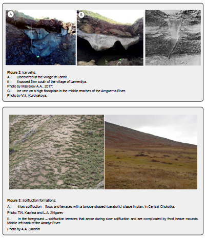
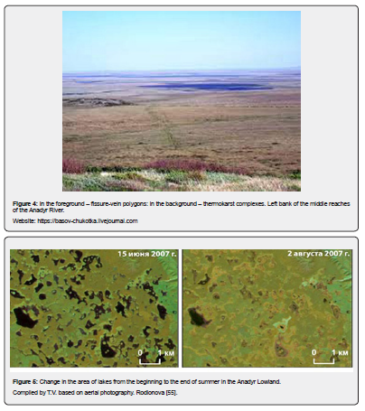
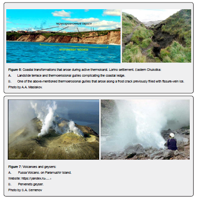
In Chukotka, among the processes that are thermodynamically significant (relatively the most energy-intensive, leading to a comparatively significant effect), thermokarst predominates; there are also “explosions” of cryogenesis activity and (or) “minor” glaciogenesis (frost crack formation – Figure 2A-2C solifluction – Figure 3A & 3B; formation of crack-vein polygons – Figure 4; seasonal dynamics of thermokarst – Figure 5; coastal transformations that occurred during active thermokarst – Figure 6A &6B).
Kamchatka is characterized by volcanic eruptions, earthquakes, landslides, talus, mudflows and tsunamis.
Of the 68 active volcanoes above water, Sarychev Peak and Fussa Volcano stand out. Fussa Volcano is a complex stratovolcano with a summit crater; currently, only fumarole activity is recorded (Figure 7).
Volcanic eruptions destroy neighboring geysers or transform them abruptly [42]. As a result, nearby glaciers begin to melt. The increasing runoff in this way straightens the riverbeds and partially destroys the valley components [43].
The Valley of Geysers has become a problematic area. Here, due to extreme impacts (during heavy rainfall during Typhoon Elsa in October 1981, a strong mudflow occurred, and large avalanches occurred), geysers were damaged. The subsequent "avalanche - landslide - mudflow - avalanche" (according to Gordeev E.I. and Melekestsev I.V. in 2007) on June 3, 2007, changed the former appearance of the Geysernaya River valley, the restoration of which is now occurring extremely slowly.
In the Continental South of the Far East, morphogenetic transformations of the GS occur:
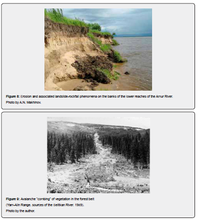
a) As a result of an increase in summer O (due to catastrophic atmospheric precipitation during the passage of deep cyclones from the west and powerful typhoons from the south, causing sudden and high floods and bank erosion in river valleys; Figure 8);
b) Due to avalanche processes (Figure 9) and landslide "explosions" (Figure 10), as well as frequent passages of tsunamis;
c) Due to an increase in winter K as a result of increased cryogenesis (for example, activation of kurum formation, in particular, on the Okhotsk Sea megacoast) against the background of increasing winter cooling;
d) Simultaneously with parallel activation of northern and (or) southern continental influences (which are associated with the formation of 2 variants of climatic asymmetry of the slopes of the valleys of small rivers);
e) Due to the deep aridization of steppe and forest-steppe natural environments, although against the background of predominantly rare long-term anticyclonic situations; and others.
Characteristics of the tsunami hazard of Pacific Russia
Geoecological risks in the region, due to increased seismicity and the associated high tsunami hazard, are very tense.
Tsunamis in the east of the region are quite common. They form high waves (more than 23m once every 100-200 years; 8-23m once every 50-100 years; 3-8m once every 20-30 years; 1-3m once every 10 years) (based on research by N.A. Shchetnikov in 1981).
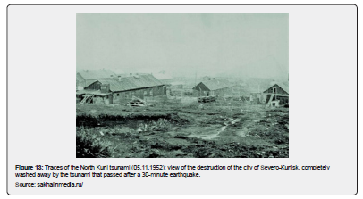
Tsunamis in Primorye are characterized by the following effects (Figure 11 & 12).
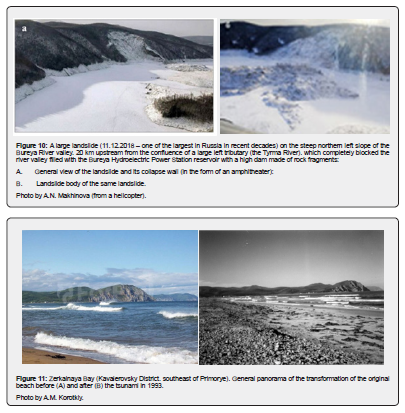
It should be emphasized that the effect of even small tsunamis significantly exceeded the combined impact of the catastrophic storms (1962-1982) [2]. In the Southern and South-Eastern Primorye, all accumulative areas, sea terraces and beaches were exposed to tsunami impacts (in particular, the coastline in the section “from Cape Povorotny to Cape Olarovsky” and further north up to Cape Zolotoy was subject to erosion). The penetration of tsunami waves into the mouths of small rivers was accompanied by the “supply” of sea sand and fragments of sea shells, and then along watercourses for a distance of 80-120m. At the mouths of large rivers, where the low lagoon terrace was blocked and surface peatlands were eroded, significant relief transformations occurred. For example, on the sea coast to the south of the Peschany Peninsula and the mouth of the river. In the Narva River basin, large layers of peat from the erosion site were moved to a distance of 300-400m to the surface of a low marine terrace at a height of up to 3m above sea level. In addition, strong storms and tsunamis, affecting the abrasion banks, caused collapses, landslides (Figure 11 & 12) and slope subsidence [2,17].

Consequently, as a result of all these processes, abrasion of the original banks and erosion of accumulative coastal forms are sharply activated, which leads to a complete reorganization of the coastal GS. At this time, various violations of economic facilities also occurred.
Tsunamis on the Kuril Islands are also usually catastrophic (Figure 13). In particular, abnormal waves of medium height (1-3m once every 10 years - according to S.L. Solovyov and Ch.N. Go in 1974) were noted here, and often high (4.5m; on the islands of Urup and Iturup, caused by the earthquake of October 13, 1963).
The Okhotsk Sea coast of the Kuril Islands is characterized by low tsunami hazard. Only relatively weakened waves (up to 1-3m high) come here from the east through the straits.
Tsunamis on Sakhalin occur periodically (approximately once every 5-10 years). They can occur in any part of the island, but the greatest probability of this phenomenon exists in its southwestern part. It is here that the highest seismic activity is observed. Significant damage to coastal areas in the southwest of Sakhalin was caused by a tsunami in 1971 [2].
Floods, heavy rains and storm surges in the Amur and Primorye regions, on Sakhalin Island and the Kuril Islands
The increase in the natural continentality of the climate causes an increase in the formation of anomalous processes and disasters in relief. Thus, floods (an increase in the level from 3.6 to 5.8m/day), caused by abnormal rainfalls (200-300mm per day), have increased quantitatively in the region over the past 50 years.
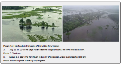
Floods in the Amur region associated with abnormal rainfalls washed away soil on river floodplains and reshaped river valleys. In large-order river valleys, in particular, catastrophic disturbances occurred. The channels and low floodplain were rebuilt; the high floodplain was subject to erosion; lateral erosion during one flood destroyed vast parts of the high floodplain and the first floodplain terrace; the alluvial fans of the tributaries disappeared. This was most noticeable in the lower and middle reaches of the Amur River and the large rivers of the eastern Sikhote-Alin (Figure 14) [44-46].
The most catastrophic floods on the Amur and Zeya rivers were observed in 1872, 1928, 1950, 1953 and 1958 [44].
Floods in Primorye are often high after prolonged moderate rainfall (up to 100mm/day), turning into downpours (80-120mm/hour), after the arrival of deep “western” cyclones, as well as powerful tropical cyclones (typhoons). At the same time, if the rise in water in the lower reaches of rivers due to flooding alone is usually 2-3m, then under additional storm surge conditions it reaches 5-7m [2].
During floods, lateral erosion processes “die out” under them, being replaced by temporarily active siltation of the entire area.
In the middle reaches of most rivers of the Eastern Sikhote-Alin, against the background of catastrophic long-term (3-4 days) floods, due to high flow rates, there was almost complete destruction of valley landscapes and many engineering structures. Similar situations (combinations of floods and storm surges) were noted by us, for example, in 1971 in sections of the lower reaches of the Kievka, Chernaya and Milogradovka rivers (water rises up to 7.0m). Thus, an increase in the height of the flood, already during its decline, here in the mouth of the Milogradovka river, a bar occurred, which led to the flooding of almost the entire surface of the lagoon terrace (up to 3-4m high) with a water column above the low water level of 6.2 m (according to measurements by R.P. Tokmakov). During the flood of 1989 in the valley of the river. Kievka (water rise 5-7m) also washed away only agricultural lands on an area of 2.5 thousand hectares, and bridges, dams, water intake structures, etc. were completely destroyed [2].
The maximum areas occupied at the specified time by flash floods and high rain floods were noted in the middle and lower reaches of all lowland rivers. At the same time, these floods simultaneously "covered" the lower reaches of all tributaries of the Ussuri and Razdolnaya rivers.
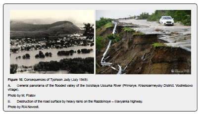
In general, floods (especially catastrophic ones) in Primorye covered huge territories within one or several water systems, led to the death of people, and caused material damage. More than 70% of agricultural land was flooded, many industrial enterprises, utilities and settlements were damaged (for example, during the flood in August 2023 – the cities of Ussuriysk and Spassk-Dalny, the villages of Pokrovka, Sarovka, Nezametnoye, Vostretsovo, etc.) (Figure 15A & 15B).
The typhoons that hit Primorye (from Emma to Lupita) are as follows:
1) Emma (September 1956; the most powerful typhoon in terms of wind speed in the entire history of observations - 45m/s; all the rivers originating in the southern part of Sikhote-Alin overflowed their banks, flooding large areas; the Amur near Khabarovsk rose to a level of 7.2m).
2) Irving (August 18, 1979; the second most powerful after Emma; 200mm of precipitation).
3) Orchid (September, 1980; wind speed 35-40m/s).
4) Phyllis (August 1981; flooded 11 cities – Aniva, Korsakov, Gornozavodsk, Dolinsk, Tomari, Makarov, Poronaysk, Uglegorsk, Krasnogorsk, Kholmsk, Nevelsk; in addition to them – 17 villages and more than 40 other populated areas; in Khabarovsk Krai, the railway station of the final section of the BAM “Dyuanka” was completely destroyed and washed away into the sea). 5. Judy (July 1989; lasted the longest; associated with abnormal showers that lasted almost a whole week, becoming the longest in the history of Primorsky Krai; accompanied by strong winds (165km/h); floods occurred (Figure 15); numerous washouts and landslides were noted; in the Lazovsky district at this time, water washed away almost all agricultural fields.
5) Robin (July 13, 1990; the record holder for the amount of precipitation per day among all typhoons - brought 244mm of precipitation to Vladivostok in 24 hours).
6) Melissa (September 1994; along with "Judy", the most powerful in terms of total precipitation - 345mm; the upper mark of the rise of water near the village of Vladimiro-Aleksandrovskoye is at a level of 10m; 678km of roads were washed away).
7) Rusa (September 2002; In the Khasansky District, over 770 hectares of agricultural land were flooded, and in the form of a cyclone it reached Sakhalin, where it caused landslides on the highway between Nevelsk and Shebunino).
8) From 2004 to 2011, typhoons did not come to Primorye (https://primpogoda.ru›).
9) Talas (September 6, 2011; rain washed away six bridges in the Terneysky District).
10) Bolaven (August 29, 2012; hurricane-force winds and heavy rain).
11) Sanba (September 18, 2012; 70mm of precipitation; roads were flooded and streams of water washed away the slope of the "road to APEC" - the retaining wall of the Sedanka-Patrokl highway).
12) Halong (July 18, 2014; numerous landslides were caused).
13) Chan-hom (July 13, 2015; 50 to 80mm of precipitation fell in 12 hours; wind speed reached 25-30m/s). 14. Goni (August 26, 2015; 50 to 102mm of precipitation fell; high floods occurred; a hole several meters deep formed on Shoshina Street.
14) Lionrock (August-September 2016; caused heavy rainfall, a three-month rainfall rate fell in three days; the Terniysky, Kavalerovsky, Chuguevsky and Olginsky districts suffered the most; forecasters called the flood against the backdrop of Lionrock one of the most powerful natural disasters in the entire history of observations in Primorye). In conditions of reduced forest area due to logging and fires, the general water-retaining and water-regulating properties of which were reduced, an abnormal destruction of the surface occurred.
15) Nemteun (September 4-6, 2016, after Typhoon Lionrock; brought up to three more ten-day rainfall rates; the water level in the rivers exceeded historical maximum by one and a half meters; 3120km of roads, 154 bridges and 265 culverts were damaged; meteorologists recognized it as one of the strongest in the entire history of observations).
16) Noru (August 2017; another large-scale flood was caused; up to 250mm of precipitation fell, or a one-and-a-half month's norm; several settlements in the Khasansky, Nadezhdinsky districts and the Ussuriysky urban district were flooded).
17) Rumbia (August 21, 2018; the most precipitation fell in the village of Barabash - 60mm in 12 hours, when the river levels reached near-critical levels).
18) Krosa (August 15, 2019; in the Khasansky district, 70% of the monthly precipitation rate fell in a few hours - 125 millimeters; water in the rivers rose to critical levels, and small rivers overflowed their banks; in the Krasnoarmeysky district of Priorye, six villages were cut off from the "mainland" - Sarovka, Novokreshchenka, Pokrovka, Izmailikha, Meteoritnoye, Limonniki; hundreds of foreign ships found shelter in the bays of Primorye).
19) Maysak (September 3, 2020; cape stations recorded wind gusts of up to 43m / s; concrete slabs of the embankment were thrown from the shore to houses).
20) Haishen (September 8, 2020; heavy rainfall - from 42 to 90mm, which caused a strong rise in water levels; gusts of 30-32m/s was recorded; according to Primhydromet, Typhoon Haishen was rainier but less windy than the previous one, Maysak, which hit the region several days earlier).
21) Maysak "and" Haishen "are the last destructive typhoons that raged in Primorye; recorded wind speeds (up to 43m/s) were observed in the region only in 1931 and in 1969.
22) Lupit (August 10, 2021; beaches were flooded on Russky Island - in the bays of Novik, Truda, as well as in Livadia, Bezverkhovo and other places in the southeast of the region, where a surge wave up to 5 meters high was observed).
23) Hinnamnor (September 6, 2022, super typhoon; led to the destruction of most of the economic infrastructure, erosion of roads, washing away of bridges, etc.
24) Hanun (August 14, 2023; 188 mm of precipitation fell in 24 hours on August 11-12; caused a flood on the Ussuri River, which was the largest in the last 10 years; 65 settlements were affected).
25) Lan (August 16, 2023, the seventh this year) heavy rains in the east of Primorye brought 80-150mm (60-120% of the monthly norm); in the upper reaches of the rivers of the Ussuri basin, the water has just begun to subside after the effects of the previous typhoon Hanun, and the new rise in water in the rivers of the basin was 0.2-1m).
The most powerful typhoons of all that came to Primorye were typhoons Emma and Irving - in terms of wind force, Judy, Melissa, Lionrock - in terms of precipitation.
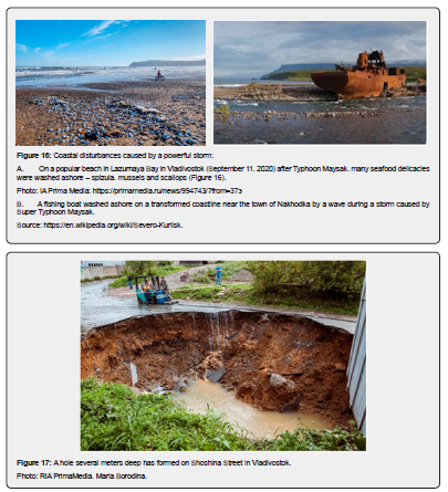
On a popular beach (September 11, 2020) in Lazurnaya Bay in Vladivostok, after Typhoon Maysak, many seafood delicacies were washed ashore - mussels, spizulas, and scallops (Figure 16A). At the same time, in the area of the city of Nakhodka, a fishing boat was washed ashore by a wave during a storm (Figure 16B).
High floods and deep sinkholes were also associated with heavy rainfall (50 to 102mm) that arrived with Typhoon Goni (August 26, 2015), which created deep sinkholes (Figure 17).
Floods and mudflows on the islands, caused by intense rainfall, contribute to mudflows and avalanches; abrasion of the indigenous banks; etc. [45-47].
The occurrence of anomalous processes in the above-mentioned territories and their catastrophic manifestation are still restrained by the high stability and plasticity of natural coastal GS.
In these areas (on Sakhalin Island and the Kuril Islands), a contradictory diversity and interweaving of natural boundaries is noted. Among them, on the one hand, northern and western continental influences are revealed, and on the other, southern and eastern oceanic influences.
The following GS changes occur here:
a) From an increase in the intensity of O in the summer (during catastrophic precipitation during the passage of deep cyclones from the west and powerful typhoons from the south, causing sharp and high floods in river valleys);
b) Due to an increase in K in winter, as a result of increased cryogenesis against the background of increasing winter cooling; and others.
In general, these spatiotemporal effects are currently intensifying and becoming more and more typical.
Typhoons accompanied by heavy rains often come to the Kuril Islands. For example, Typhoon Hagibis (13.10.2019) with strong winds (up to 33m/sec) brought heavy rains. They were followed by floods and landslides (according to the Hydrometeorological Service, 2019). Storm surges (up to 2-5m) were observed in open coastal areas of the islands.
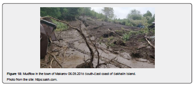
On Sakhalin Island, summer-autumn rains contribute to the occurrence and passage of mudflows (Figure 18). The volumes of mudflow material present here reach tens of thousands of cubic meters. The mudflow-hazardous areas include the regions of the South Coastal Mountain Range and the Sea of Okhotsk region [47,48].
Forecast features of continentality and oceanicity
The Far East, as already noted, is located in a steadily active transition-contact zone of the two greatest structures of the Earth (the Asian continent and the oceans - the Arctic and Pacific with their seas).
Features of the development of the GS of Pacific Russia are most clearly manifested with the participation of continentality (K; mainly winter) and oceanicity (O; due to monsoon). On the territory of the region, it is characterized by a clear spatio-temporal differentiation of intensity: in continental areas it has minimal values; in coastal areas (in the interweaving strip of K and O, within island arcs and megacoasts) - maximal [48]. This is clearly seen in the case of 2 variants of asymmetry of the slopes of the valleys of small rivers - stable northern and southern in intracontinental territories against extremely dynamic in coastal areas [49]. The main distinguishing features in the region are additionally inter- and intra-seasonal changes in aridity and humidity and, as a consequence, the contrast of system-forming and transforming natural factors and processes. In relation to the values of continentality and oceanicity, the percentage of probability of the origin and development, respectively, of related anomalous processes and catastrophes is laid down. For example, the number and intensity of abnormal processes in the coastal zone increases - the frequency of storms and storm surges increases, as well as the erosion of sea coasts and underwater coastal slopes, etc. As a result, the zone of active mutual superposition and interpenetration of K-O at present, emphasized by the motley alternation of forms, processes and formations of "alien" origin (in the goltsy zone of mid-mountains: kurum formation and permafrost sorting of soils versus nivation forms; along the valleys of mountain rivers: nalediments versus deflation with aeolian movement of snow; and others), is shifting to the east, to the coastal zone. The frequency of recurrence of extreme processes and their impacts on the GS in the highly energy-intensive continental margin of the Russian Far East has increased in recent decades, and the scope of "natural risks" has expanded.
Evaluation of the characteristics of K and O as a tool for identifying areas with varying degrees of environmental risks is extremely relevant. Below are proposed original, in the author's opinion, methods for determining K and O for recorded natural objects at the continental and regional levels.
Each type of continentality and oceanicity in the Far East corresponds to its own spectrum of anomalous phenomena (AP):
a) In the area of predominant continentality, the following AP are characteristic - dry winds (they correspond to high air temperatures around midday - from 25-350 to 45, and on the soil up to 600; moisture deficit up to 15-35%; strong winds up to and more than 20m/sec), dust tornadoes, droughts, drying out of the soil and death of plants, fires, physical (temperature) weathering, frost cracking and drying cracks, kurum formation, rockfalls, screes, etc.;
b) In the area of predominant oceanic conditions – typhoons, storms and storm surges, heavy rains, floods, mudflows, landslides and landslides, erosional washouts, snow avalanches and others.
Continental level and analysis of climograms
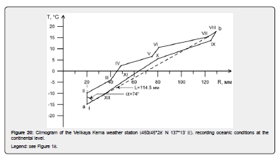
General (annual) K and O are determined in the course of thematic analysis of climograms constructed based on the indicators of average monthly air temperatures (T°C) and average monthly precipitation amounts (R, mm) based on information from weather stations in the Far East. We accept the climogram as a graphical representation in the system of rectangular coordinates of the annual course of T (along the ordinate axis) and R (along the abscissa axis). The combined points of these characteristics, connected by straight line segments, form a closed contour. The dotted lines connecting the distant points (these are a and b) are accepted as the resulting climograms (Figure 19 & 20).
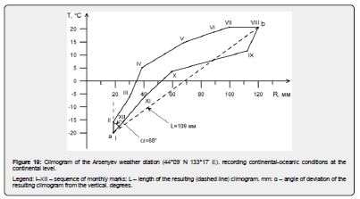
The resulting climograms, as follows from our analysis of their entire array, indicate that the objects belong to continental and close-to-continental settings (with resultant slopes from the vertical less than 45°) or to oceanic and close-to-continental conditions (with resultant slopes, respectively, greater than 45°). In this case, the lengths of the resulting ones selected in this way are proportional to the degree of K and O: the shorter the length of the resulting climograms, the greater the degree of K, and the longer the length, the greater the degree of O. The figures provided (see Figure 19 & 20) show that the Arsenyev weather station is located in conditions close to continentality, and the Velikaya Kema weather station is in conditions of actual oceanicity.
In general, we distinguish the following energy situations based on the climograms:
a) by the slopes of the resultants from the vertical: from 0 to 200 (rarely up to 250) – continental (K); from 20 to 450 – oceanic-continental (O–K); from 45 to 700 – continental-oceanic (K–O); from 70 to 900 – oceanic (O);
b) by the length of the resultants: up to 70mm – continental (K); from 70 to 90mm – oceanic-continental (O–K); from 90 to 110mm – continental-oceanic (K–O); from 110mm and more – oceanic (O).
Regional level and analysis of climograms
In regional settings (particularly in Primorye), the prevailing summer K and O are detected in July and August, respectively, which is traced based on the results of the temporal confinement of the maximum air temperature (in our case, based on data from 92 meteorological stations in Primorye) [50].
Thus, the conditions of maximum summer K were recorded in July (between the state border and the Sikhote-Alin ridge watershed; Arsenyev meteorological station, 1955, Tmax 27.8°C); and the prevailing summer O – in August (within the Sea of Japan megacoast; Vladivostok-port meteorological station, 1955, Tmax 26.1°C). Consequently, the generic affiliation of K and O is identified depending on the location of objects at specific levels of organization of the geographic envelope, identified (at the global and close to it continental) by climograms or determined (at the regional and close to it local) by the maximums of summer air temperature.
Therefore, in the course of an express analysis of the K and O conditions, it is necessary to operate not only with the generally accepted coefficients of winter and general K in the literature [51,52], but also with the author's characteristics of general K and O at the continental level, as well as additional features of summer K and O at the regional level (manifestations of maximums of air temperature in July and August, respectively).
Current ecological state of the Far East
The predominance of continental or oceanic influence on the development of the relief of the south and north of the Russian Far East is always expressed in the activation of exogenous processes characteristic of each of the influences. Thus, in the first case, arid and permafrost processes are activated during exogenous morphogenesis, in the second - humid and glacial-nivation.
Specific indicators (qualitative or quantitative) of the intensity, direction and ratio of arid and permafrost - humid and glacial-nivation relief-forming processes help to identify trends in the development of the above-water relief of the Far East. Factors and processes involved in the creation and further development of the GS of the Far East differ in intensity and time of manifestation.
According to these features, they are separated into two groups: typical and anomalous. The frequency and intensity of abnormal phenomena (critical and crisis) are clearly related to the levels of K and O. Thus, at maximum values of various K or O, the most intense abnormal phenomena are observed, and at minimum values, relatively less intense ones. At the same time, abnormal phenomena (mainly critical) are often turning points in the development of the GS, when a return to typical processes opens up opportunities for restoring the original state, and their transition to crisis processes leads to the beginning of the destruction of landscapes [2,34].
According to our data, the ratio of K and O values contains the percentage probability of the origin and development, respectively, of related anomalous (arid and permafrost, humid and glacial-nivation) processes and catastrophes. For example, even now, on the eastern edge of the Eurasian continent, the influence of winter K and relatively weakening O (especially clearly since the mid-20th century) on the course of landscape genesis is increasing. Here, on the territory of the Okhotsk Sea megacoast - the arena of the ubiquitous influence of O - new kurums are originating and ancient ones are reviving (as a product of increasing continental influence), where until recently they were present only in relict forms. At the same time, the number and intensity of anomalous processes in the coastal zone is increasing - the frequency of storms and storm surges is increasing, and the erosion of seacoasts and underwater coastal slopes is intensifying, etc. the range of Daurian birch (Betula davurica Pall.) (an indicator of emerging continentality) is expanding to the east to the main watershed – the Sikhote-Alin ridge [53].
Significant adjustments to the specified development of the GS can be made by global warming, if the latter really continues everywhere [54,55].
Sharp changes in warming or cooling of the climate lead to an increase in the frequency of abnormal processes and phenomena and, as a consequence, to an increase or decrease in the activity of thermokarst, droughts, floods and storms, sea ice, thinning of vegetation, frost cracking of soils, etc.
The ecological background of the Far East is characterized by exceptional tension, with significant differences in the north and south.
In modern natural and climatic conditions in most of the northern part of the Far East, the activity of natural processes is high, but is still observed within the background norm of typical and, less frequently, critical levels [2]. Here, exogenous anomalous development trends are determined mainly by: the influence of winter K (due to the activation of permafrost processes against the background of the impact at this time of not only the frozen continental surface, but also the ice-covered waters that prevail for most of the year); a multifaceted combination of O and K in summer (increased thermokarst activity due to the sharp thawing of soils, during rare anomalous showers and (or) warming during observed "anticyclonic" situations). The cryogenic hazard in many anthropogenic and anthropogenically altered areas in the north of the region, as well as in neighboring Yakutia [56], reaches catastrophic levels. If the emerging global warming of the climate manifests itself [57], then the processes of thermal abrasion along the seacoasts will be activated, and in the rest of the territory there will be an increase in thermokarst, solifluction, landslides and mudflows.
In the south of the Far East, morphogenetic transformations of the GS occur as a result of an increase in summer O (due to catastrophic precipitation during the passage of deep cyclones from the west and powerful typhoons from the south, causing sharp and high floods in river valleys); an increase in winter K, leading to an increase in cryogenesis (activation of kurum formation, in particular, on the Okhotsk Sea megacoast) against the background of increasing winter cooling; parallel activation of northern and (or) southern continental influences, which are associated with the formation of two variants of climatic asymmetry of the slopes of small river valleys); deep aridization of steppe and forest-steppe natural environments against the background of predominantly rare long-term anticyclonic situations, etc. [58,59].
Dangerous or anomalous natural phenomena are often repeated and cover significant territories of the south of the Far East [2,44].
Space-territory as an arena of complex development of natural disasters
Conclusion
All exogenous processes with the participation of factors are tied in their functioning to a certain volume of "Space-Territory". Noting our understanding of the latter objects, we move on to a kind of Conclusion on the entire Content of the conducted research.
"Space and Time" in the scientific picture of the world
Their thematic reflection begins with ancient philosophers (Plato, Aristotle), then continues with later natural scientists (I. Kant, I. Newton, A. Einstein, G. Minkowski, M. Aksenov, P.P. Semenov-Tyanshansky, V.A. Obruchev, V.I. Vernadsky), then is noted in fiction and real time (L.N. Tolstoy, I.S. Turgenev, M.A. Bulgakov, J.B. Moliere) and, finally, is additionally revealed closer to the present time (D. Masser, P.P. Gaidenko, M.D. Akhundov, etc.).
The author understands “Space and Time” together as “timespace”, that is, as “time-space”. It has been traced that the development of the GS occurs in time and space simultaneously and continuously (unevenly and intermittently), along 2 paths - evolutionary and catastrophic.
In thematic studies "Space-Time" such a secondary, but independent, category as "Territory" is usually separately identified. Although we do identify it, we consider it in unity with Space.
Space - territory
In their comparison, a certain paradox is visible. On the one hand, they are externally close in many ways, but internally heterogeneous. This is explained by the fact that their main difference is in dimensionality - space is always 3-dimensional and without boundaries, and territory is 2-dimensional and with boundaries. In the latter case, the perception of territory is accepted as linear-planar. In general, we admit that in the course of their close interaction, some exchange of properties briefly occurs: space in individual areas acquires the expression of boundaries, and territory volumetric-spatial outlines. Thus, in the course of the development of the GS, they are interconnected in their complex unity. Therefore, we accept them as one concept of "Space-Territory".
In the evolutionary change of space and territory, the expression of the convergence principle is clearly visible - in similar natural conditions, their structure converges and (or) acquires similar or coinciding features. Thus, in the course of close interaction of the territory in space, some mutual exchange of properties briefly occurs: space in individual areas acquires the expression of boundaries, and the territory volumetric-spatial outlines. Thus, space and territory are enriched in the course of development, being interconnected in their complex unity. Therefore, although their differences are taken into account, we accept this unity as one general concept of an inseparable "space-territory".
Features of the reflection of the development of the GS
The author has traced that it occurs in time and space simultaneously and continuously (unevenly and intermittently), along 2 paths - evolutionary and catastrophic. It is necessary to take into account that the habitat (as a factor of place) and the geographical position of space relative to the Sun and the cardinal directions, dividing environment-forming factors, control and direct the said self-development of Space and Time interconnected with it. As a result, there arises simultaneously progressive and continuous (uneven and intermittent) development of Space and Time. The division of Space and Time according to the mode of functioning and environmental perception forms their unique specificity as Duality. These spatio-temporal states, ultimately, are distinguished by cosmic predetermination, and at the same time by adherence to metachronicity [6], cyclicity and rhythm. With regard to the development of natural objects (including relief, as the most indicative for this), most fully traced only by taking into account the unevenness and intermittency (as catastrophicity) of the manifestation of endogenous and exogenous forces, it is possible to explain the nature of their specificity. The latter is explained by the fact that the creation of increasingly complex and perfect forms is an immanent property of living nature [60] and not only living nature].
The GS, developing within the framework of "from the Past through the Present to the Future" (in accordance with the axiom of the vectorial development - the Arrow of Time of Eddington-Prigogine), is subject to the general Law of Complication - the most fundamental law of the development of the Universe [61]. At the same time, the development of the GS is constantly becoming more complex, and the level of complexity is constantly increasing in a targeted manner. At the same time, the tendencies of the development of the GS, with relative similarity on a natural and anthropogenic background, do not coincide territorially everywhere.
At the same time, various categories of Space and Time are revealed in the functioning of the GS. These categories are not only physical, but also moral are reflected in the course of rational nature management.
dropdown Start here
References
- Kolomyts EG (2017) Pacific megaecotone of Northern Eurasia. Evolutionary model of the continental biosphere. E.G. Kolomyts. Moscow: GEOS, p. 496.
- Korotky AM, Korobov VV, Skrylnik GP. (2011) Anomalous natural processes and their influence on the state of geosystems in the south of the Russian Far East. Vladivostok: Dalnauka, p. 265.
- Kalesnik SV (1946) Fundamentals of general geoscience. Moscow, Leningrad: Uchpedgiz, p. 483.
- Grigoriev AA (1937) Experience of analytical characteristics of the composition and structure of the physical-geographical shell of the globe. Leningrad, Moscow: Publishing House of the Chief Ed. Mining and Fuel Oil. and Geological Prospecting Literature, p. 68.
- Nikolaev VA (1978) Classification and Small-Scale Mapping of Landscapes. Moscow: Moscow University Press, p. 62.
- Markov KK (1965) Space and Time in Geography. Priroda 5: 56-61.
- Kuzmin SB (2009) Dangerous Geomorphological Processes and Risk of Nature Management. Novosibirsk: GEO 195, pp. 56.
- Grigoriev AA (1970) Types of Geographical Environment. Selected Theoretical Works. Moscow: Mysl, p. 472.
- Ufimtsev GF (1991) Space-Time of Relief. Geomorphology 3: 29-39.
- Timofeev DA (1992) Geomorphological time and spatio-temporal relationships in the relief of the earth's surface. Bulletin of the Russian Academy of Sciences. Geographical series No. 4, pp. 12-18.
- Harvey D (1974) Scientific explanation in geography (Translation from English). Moscow: Progress, p. 502.
- Wallerstein I (1993) The time space of world-systems analysis: a philosophical essay. Historical Geography No. 1/2, pp. 5-22.
- Kozyrev NA (1991) Man and Nature. Selected works. Leningrad: Leningrad University Publishing House, pp. 401-409.
- Sochava VB (1978) Introduction to the Doctrine of Geosystems. Novosibirsk: Nauka, p. 319.
- Skrylnik GP (1990) Dynamic Aspects of Climatic Geomorphology. Regional and Local Aspects of Exogenous Relief Formation in the Far East. Vladivostok: TIGDVO USSR Academy of Sciences, pp. 4-19.
- Timofeev DA (1974) Unevenness of Relief Formation in Time and Space. Problems of Regional Geomorphological Analysis. Publishing House of the Geogr Society of the USSR, pp. 16-19.
- Gotvansky VI, Lebedeva EV (2010) Influence of Natural and Anthropogenic Factors on the Intensity of Geomorphological Processes in the Far East. Geomorphology No. 2, pp. 26-36.
- Govorushko SM (2007) Interaction of man with the environment. The influence of geological, geomorphological, meteorological and hydrological processes on human activity: a reference manual. Moscow: Academicheskiy proekt, p. 684.
- Skrylnik GP (1994) Geomorphological risk and stability of the Far East geostationary system. Northern Pacific: abstracts. Int conf (Vladivostok, August 30 – September 4, 1994). Vladivostok, pp. 67-69.
- Myagkov SM (1995) Geography of natural risk. Moscow: Moscow University Press, p. 222.
- Korotky AM, AM Korotkiy, GP Skrylnik (2005) Relief, natural risks and disasters. New and traditional ideas in geomorphology. Y Shchukin readings. Works (Moscow, May 16-20, 2005, Faculty of Geography, Moscow State University). Moscow: Moscow state University, Russian Foundation for Basic Research, pp. 259-263.
- Bak P, Chen K (1972) Self-organized criticality. In the world of science. Scientific American (Russian-language edition). Moscow: Nauka, p. 423.
- Demographic encyclopedic dictionary (1985) In: DI Valentey (Ed.), Moscow: Sov. encyclopedia, p. 608.
- Landscape and ecological assessment of the territory.
- Skrylnik GP (1979) Schematic diagram of climate morphogenesis types. Studies of global factors of climate morphogenesis in the Far East. Vladivostok: Dalnauka, pp. 47-50.
- Skrylnik GP (2023) Anomalous trinity (criticality-crisis-catastrophic) in the development of geosystems of Pacific Russia. Geopolitics and Ecogeodynamics of Regions 9(2): 273-290.
- Kachur AN, Skrylnik GP (2022) Continentality and oceanicity as indicators of the current ecological state of the Russian Far East. Geography and Natural Resources 3: 40-45.
- Keith M (2019) Changes in the hydroclimate of the 20th century, according to Facing Human Influence. In: Keith M, Benjamin E Cook, Celine JW Bonfils, et al. (Eds.), Nature 569: 59-65.
- Climate Change 2014: Synthesis Report. Contribution of Working Groups I, II, and III to the Fifth Assessment Report of the Intergovernmental Panel on Climate Change. In: RK Pachauri, LA Meyer (Eds.), IPCC, Switzerland, Geneva, p. 163.
- Smith LC, Sheng Y, Macdonald GM, Hinzman LD (2005) Disappearing Arctic lakes. Science 308(5727): 1429.
- Lovelius NV, Reteyum A Yu (2018) Cycles of solar activity in the Arctic. Society. Environment. Development 1: 128-130.
- Nikolskaya VV (1974) On natural trends in the development of physical-geographical provinces of the southern Far East. Novosibirsk: Nauka, p. 127.
- Skrylnik GP (1977) Kurume formation and the general tendency of development of the relief of the Far East. Geomorphology and neotectonics of the mountainous countries of the Far East. Vladivostok, pp. 86-88.
- Skrylnik GP (2020) Natural risks, crises and disasters in the Russian Far East. Pacific Geography 3: 18-28.
- Maksimov AA (1989) Natural cycles. Causes of recurrence of environmental processes. Science, 236.
- Kuzin P.S. Cyclic fluctuations in river runoff in the Northern Hemisphere. L.: Gidrometeoizdat, 1979. 180 p.
- Agadzhanyan NA (1976) Chronobiology and the problem of adaptation. People, space and time. Knowledge, pp. 18-30.
- Romanov Yu A (1976) Cell, rhythms and life. People, space and time. Knowledge, pp. 31-49.
- Skrylnik GP (2019) Space-time in the development of geosystems and natural risks. Arctic and Antarctic 1: 1-14.
- Pozdnyakov AV (2003) On the Theory of Spontaneous Self-Organization of Complex Structures. Self-organization and Dynamics of Geomorphosystems (Proceedings of the XXVII Plenum of the Geomorphic Commission of the Russian Academy of Sciences). Tomsk: Publishing House of the Institute of Atmospheric Optics SB RAS, pp. 30-43.
- Osipov VI (2002) Natural Risk Management. Bulletin of the Russian Academy of Sciences 72(8): 678-686.
- Active Volcanoes of Kamchatka [collective monograph, scientific publication] in 2 volumes (vol. 1, 394 p.; v. 2, 416 p.). M.: Nauka, 1991.
- Melekestsev IV, Braitseva OA, Ponomareva VV, Bazanova LI, Pevzner MM, et al. (2003) Endogenous catastrophes in the Holocene in Kamchatka and the Kuril Islands. Reports of the Academy of Sciences 389(5): 662-665.
- Makhinov AN, Kim VI (2020) The impact of climate change on the hydrological regime of the Amur River. Pacific Geography 1: 30-39.
- Bolgov MV, Alekseevsky NI, Gartsman BI, Georgievskiy V Yu., Dugina IO, et al. (2015) Extreme flooding in the Amur basin in 2013: analysis of formation, assessment and recommendations. Geography and Natural Resources 3: 17-26.
- Atlas of the Kuril Islands / Ed. - cartographer E Ya Fedorova. Russian Academy of Sciences. Institute of Geography of the Russian Academy of Sciences. Pacific Institute of Geography of the Far Eastern Branch of the Russian Academy of Sciences. M.-Vladivostok: IPC "DIK", 2009, p. 516.
- South of the Far East: (History of relief development of Siberia and the Far East). In: Academician AL, Yanshin (Eds.), (Geosciences) V.A. Nikolaev. Moscow: Nauka, 1972, p. 423.
- Geosystems of the Russian Far East at the Turn of the 20th-21st Centuries. Vol. 1. Natural Geosystems and Their Components / Responsible editor S.S. Ganzey. Vladivostok: Dalnauka, 2008, p. 428.
- Skrylnik GP (2021) Far-Eastern specificity of the relief forms’ asymmetry (by the example of the Russian Far East). Chronos 6(3): 8-13.
- Scientific and Applied Handbook on the USSR Climate. Long-Term Data Series. Parts 1-6. Issue. 26. Primorsky Krai. L.: Gidrometeoizdat, 1988, p. 416.
- Khromov SP, Mamontova LI (1974) Meteorological Dictionary. Gidrometeoizdat, p. 568.
- Simonov Yu G (1972) Regional Geomorphological Analysis. M.: Moscow University Press, p. 252.
- Kurentsova GE (1973) Natural and Anthropogenic Changes in Vegetation in Primorye and Southern Priamurye. Novosibirsk: Nauka, p. 231.
- Global Atmosphere Watch Programme (GAW) [Electronic resource]. https://public.wmo.int/.../programmes/global-atmosphere-watch programme.
- Rodionova TV Study of thermokarst lake dynamics in different areas of the cryolithozone of Russia based on space images. Moscow: Moscow University Press, 2013, p. 196.
- Alekseev VR (2017) Cryogenic hazard in the nature of the Earth. Science and Technology in Yakutia 1(32): 1-17.
- Kaplin PA (1971) Features of the dynamics and structure of the coasts of the polar seas (using the Chukchi Sea as an example). New Studies of Coastal Processes. Moscow: Science, pp. 22–34.
- Kaplin PA, Selivanov AO (2006) Global warming and its influence on sea level. Modern global changes in the natural environment. Moscow: Scientific World 2: 94-121.
- Skrylnik GP (2011) Anomalous natural processes and their influence on the state of geosystems in the south of the Russian Far East. Vladivostok: Dalnauka, p. 265.
- Berg LS (1922) Nomogenesis or Evolution Based on Regularities. Petersburg: State Publishing House, p 306.
- Shpakovsky RP (2014) On the thermodynamic "arrow of time". Modern problems of science and education. Technical Sciences 6:


