Sustainable Development of Waterways Transportation in Benin (West Africa)
Messan Lihoussou1* and Lazare A Sossou-Agbo2
1Associate Professor at IUT of the University of Parakou, Benin & Associate Researcher at UMR Idées-Le Havre Normandie, France
2Associate teacher at’ UCAO-Cotonou and MIRD –UAC, France
Submission: December 11, 2023; Published: December 22, 2023
*Corresponding author: Messan Lihoussou, Associate Professor at IUT of the University of Parakou, Benin & Associate Researcher at UMR Idées-Le Havre Normandie (France), Email ID : messan.lihoussou@yahoo.fr
How to cite this article: Messan L, Lazare A Sossou-A. Sustainable Development of Waterways Transportation in Benin (West Africa). Int J Environ Sci Nat Res. 2023; 33(1): 556354. DOI 10.19080/IJESNR.2023.33.556354
Abstract
In West Africa, Beninese government authorities now advocate improving the use of inland waterways as an effective, sustainable and resilient response to road congestion and pollution. This vision is expressed in numerous projects including the redevelopment of the lakeside town of Ganvié in So-Ava, the dredging of Lake Ahémé in order to give it a better depth for securing fishery resources, the organization of the transport of passengers between Abomey-Calavi, Cotonou and Porto-Novo cities. This contribution focuses on the challenges and perspectives of waterways transportation and port activities development.
The methodological approach is mixed : quantitative and qualitative. It is based in one hand on the collection of data through semi-directive interviews with the different stakeholders (40 people) : authorities and municipal development associations, populations living on these bodies of water, artisanal and waterways carriers (canoe operators, guides and traders). On the other hand, it is interested in the analysis of statistics from governmental and international institutions, study mission reports and a questionnaire survey of 87 actors chosen in a reasoned manner. The results show that developments on bodies of water in south Benin can promote passengers and goods inland waterways transportation, artisanal local units manufacturing canoes and motorized boats. The reforms will improve sustainaible and resilient mobilities, enhance port competitiveness through inland waterways terminals and stations towards the country.
Keywords: Waterways transportation; Sustainable development; Mobilities; Inland terminals; Cotonou-Lagos Corridor
Introduction
Sustainable transportation development stands as an important issue for UN Sustainable Development Goals (Goals 3, 9 and 11) by enhancing economic growth and improving accessibility. Transport and its supports are very determining in people and goods mobilities, in spaces structuring of the development of territories at urban, national, regional and international scales [1,2]. So, environmental impact (Goals 7, 13 and 15) becomes very crucial with the scarcity of natural resources. All the humanity has always relied on large inland waterways in order to obtain fish, energy and drinking water resources for its daily consumption and to fuel its commercial exchanges with inland territories [3,4]. In Africa, large rivers draw natural borders between countries, concentrate important human, social and economic activities and constitute real tools for internal penetration, economic integration and regional cooperation [5,6]. Waterways transportation relies on large rivers such as Nile (6650km), Congo (4700km), Niger (4200km), Oubangui-Uélé (2270km), Kasaï (2153km), Senegal (1700km), Ogooué (893km). These inland watercourses mark the birth of powerful transport corridors which are gradually abandoned in the face of strong competition from the road [3,5], armed by the Bretton Woods Institutions and the Western Auto Manufacturers lobby. This results in road transportation domination, with rail being less dense, inefficient and even dismantled in places [7].
However, the various crises (environment, health, political, energy, social, economic) facing all of humanity raise serious concerns about the sustainability and resilience of transportation systems [8]. Indeed, the world is experiencing an important environmental crisis accentuated by health crisis linked to Covid-19, political crisis of the Russo-Ukrainian war and consequent energy and food crises. The world is finally realizing that planetary resources are not inexhaustible and that natural environments are deteriorating almost irreversibly. This apocalyptic diagnosis now focuses all attention on modes of transport that are more environmentally friendly, hence the revival of waterways transportation [3,4]. Waterway transport is positioned as a credible, sustainable and resilient solution to new logistical challenges in Africa in general and more particularly in West Africa [5,6]. Sustainable development is a concept of development which takes a long-term perspective by integrating environmental and social constraints into the economy. According to the definition given in the report of UN World Commission on Environment and Development (UN-WCED, 1987), called the «Brundtland Report», «Sustainable development is development that meets the needs of the present without compromising the ability of future generations to meet their own needs».
In Benin (West Africa) for several years, waterway corridor has been the axis favored by transporters of all kinds to connect the big Lagos City and surrounding areas [9]. The use of this axis increased with the closure of the land borders between Benin and Nigeria on August 19th, 2019 for various reasons including health. After this opening of the land borders, waterways mobility increased, which proves the enthusiasm of the populations to use the water route while abandoning the road route for a time. Several reasons explain this enthusiasm. First, repetitive and excessive checkpoints on the road axis are fueled by significant illegal levies, with less rigor in the negotiations between carriers and control agents 40n.
Second, the waterway offers an opportunity to reach all the renowned markets of Nigeria (Eboutero, Adjégounlè and Mile 2), without making detours or transshipment. It is with low congestion and pollution. This political decision has only strengthened the dynamics of the waterway corridor through commercial exchanges, imports and exports between the two countries. Lagos, Cotonou and Porto-Novo cities share waterways of several kilometers which open onto the Atlantic Ocean forming with the Niger River, a vast deltaic zone in the maritime space of Benin-city in Nigeria. The whole described forms a waterway corridor delimited by this axis and cities [10,11].
For Claude COMTOIS [12], a corridor is an axis which gives access to a place and, by extension, expresses the concentration of flows. Thus, all corridors display some form of linear configuration. According to the same author, five criteria make it possible to assess the commercial power of a corridor : the presence of a network of active metropolises, maritime transaction centers, major transport interfaces, intermodal synergy and the lowering of tariff barriers. The physical dynamics of the Cotonou-Lagos lagoon space are displayed in the direction of traffic which is controlled by the location of the entry and exit points between which a polarity develops. Checkpoints have been strengthened by political influence. There were up to fifteen ‘checkpoints’, which has unfortunate consequences on individuals transportation and mobility. These checkpoints are sometimes administered by several agents (Customs, Police, Military, Water and Forestry, environment and Health agents). Hence the question of whether the Cotonou-Lagos corridor constitutes or could constitute a major axis for the movement of people and goods ? How to promote waterways transportation for sustainable and resilient development of the South Benin ? So, this paper aims to assess the issues, challenges and prospects for waterways transport development in Benin thanks to Nigerian experiences. The development of this paper revolves around two main axes. The first axis presents the embryonic state of waterways transportation with enormous potential. The second is devoted to avenues of reflection for the development of this mode of transportation and especially its participation in improving the competitiveness of the port of Cotonou.
Materials and Methods
The methodological approach mobilizes quantitative and qualitative approaches. It analyzes statistics, although incomplete and very difficult to collect, from governmental and international institutions and research reports. It is also based on data collection in Benin and Nigeria through semi-directive interviews with the various stakeholders (40 people) : authorities and municipal development associations, populations living on these bodies of water, river transport stakeholders (canoe operators, guides and traders). Added to this is a questionnaire survey of 87 actors chosen in a reasoned manner. The field work took place in the period from February to July 2023 by direct observation and surveys with stakeholders in Sô-Ava, Dantokpa (Cotonou), Maria- Tokpa (Porto-Novo) and the Ahémé Lake area. A tour guided by the President of the Benin Waterways Transport Association and responsible for the company “Only God Marine Service” serving as a participant observation took place on July 14, 2023 on the Porto- Novo lagoon corridor – Lagos. It consisted of following the lagoon route to collect dysfunctions and obstacles, the organization and operation of interstates waterway transport from Porto-Novo to Lagos, the practices of the actors, using a motorized boat rented for the whole day and driven by a qualified helmsman and his assistant. This corridor is boosted today by passengers transport between the two cities. The quantitative data collected are processed and analyzed statistically while the qualitative data were subject to content analysis.
Results and Discussion
Challenges in sustainable development of Waterways transportation in south Benin
Waterwyas transportation in Benin encounters two major problems : natural and economic. Navigation can only be developed naturally in plain regions with vast bodies of inland water, with powerful and slow rivers, fed regularly. To develop this natural setting, it will be necessary to regularize the bed of the watercourse with dams, locks, groynes and dikes. Obstacles must also be bypassed by canals or waterways must be joined together by junction canals with locks, elevators and tunnel boring. On an economic level, the development or modernization of existing waterways requires financial efforts which are only made to the extent that they are considered profitable, especially in countries like Benin where resources are low. The inland waterway industry may consist of barges, self-propelled boats, especially pinnaces and simple motorized or non-motorized canoes, which provide most of the river traffic. In Benin, river transport mainly concerns sand extraction activities, the exploitation of waterways for the illicit traffics of petroleum products coming from Nigeria, the operation of some commercial infrastructures and passengers transport. It concerns local and interstate waterways transport.
Local waterways transportation generates significant mobilities
In Benin, more than 90% of foreign trade is carried out by sea [7] even if around 80% of commercial trade in West Africa is carried out by road [7], the fishing, tourism and waterways transport sectors currently contributing very little to the blue economy. It should already be noted that the statistics are very insufficient or even unavailable or lie dormant in the drawers of administrations which sometimes neglect or fear their dissemination. River transport takes place in the south of Benin between urban and peripheral areas crossed by the Ouémé river, the Nokoué and Ahémé lakes and the Porto-Novo lagoon.
Several surveys have shown the deterioration of the living conditions of traditional fishing populations forced to change career paths. Faced with the decline in their fishing catches and the significant loss of income among these populations, the government of Benin has committed to the dredging of the Aho channel and the mouth of the Mono river, the channel and the coastal lagoon. These adjustments seem to be bearing fruit. Marine aquatic species migrate easily and have found spawning grounds to deposit their eggs. These migrations allowed artisanal fishermen to fish for species that they never saw again in the channel, nor in Lake Ahémé, nor in the coastal lagoon. Beyond this important contribution to the improvement of inland fishing, this rehabilitation of the water bodies of south Benin (Lakes Nokoué and Ahémé and their channels) fundamentally aims to revive and professionalize urban mobilities by waterways to relieve road congestion. The Figure 1 below presents waterways devoted to circulation.
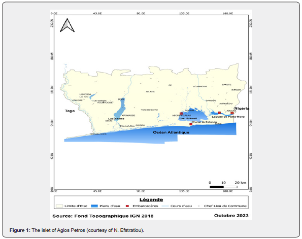
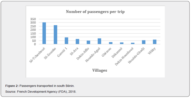
In Benin, waterways transportation is still considered as transportation mode of marginal populations, nevertheless generates significant mobilities and goods transport to various markets. The Figure 2 below shows the importance of mobilities thanks to waterways transportation in the south Benin.
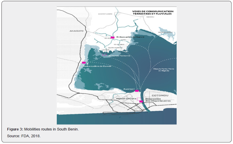
This Figure 2 shows that the villages with high mobility are : Sô- Tchanhoué (302 people transported in one trip), Sô-Zounko (266 people), Ganvié (95 people) and Sô-Ava (71 people) with a total of 32,110 passengers / month or approximately 385,000 passengers transported annually. We must add to these mobilities those which are developing between Cotonou and Porto-Novo. Furthermore, Figure 3 shows the land and river communications routes in the south of Benin to highlight some market infrastructures on the water.
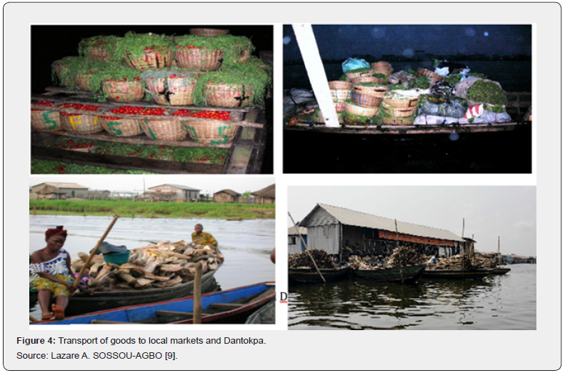
This Figure 3 presents the tourist circuits possible via these routes but which are still little valued and exploited. The goods transportation makes it possible to supply even floating markets and constitutes the second exploitation of these local navigable routes (see Figure 4 below).
These pictures in Figure 4 shows the transport of baskets of fresh tomatoes and various goods towards the populations settled on the water and in the opposite direction packages of smoked fish and other fishing products.
Interstates waterways transportation : efficient, sustainable and resilient mobility model
Interstates waterways transportation involves passengers with their luggage. It develops between Cotonou or Porto- Novo in Benin and mainly Lagos in Nigeria. It is important to point out that the activity is still very embryonic, not properly regulated, with actors without qualifications but who aspires to professionalization. Likewise, the trafficking of goods which promotes commercial exchanges between the two countries and especially cross-border smuggling [10]. The Figure 5 below shows this waterways corridor from Cotonou to Lagos in West Africa, where the route is shown in red.
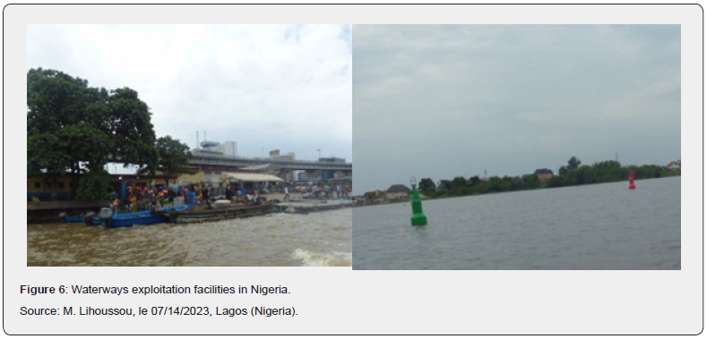
The organization and operation are very contrasting when we move from Benin to Nigeria. Indeed, our field work on the Porto- Novo to Lagos route shows on the Beninese side although the border line is not very marked, an unmarked circuit, an artisanal river station at Maria-Tokpa, checkpoints not very well equipped with patrol equipment. In Nigeria, the routes are clearly marked and there is a river station called “Five Towers Niwa Marina Jetty” (CMS) located not far from the headquarters of the Nigerian Ports Authority, developed and organized in Lagos as the case in Dakar (Senegal) or Abidjan (Côte d’Ivoire) (Figure 6).
This Figure 6 shows the CMS station and markers on the Lagos Lagoon. Still in Nigeria, there are several well-established checkpoints equipped with powerful motor boats to pursue smugglers and professional actors. As proof of this organization, the river station has all the characteristics of a real secure station, with multimedia supports to announce departures and arrivals, pass messages from the Nigerian national waterways management authority and publish fares transportation for each destination (Table 1).

We also note among the populations of Lagos habits of using river transport and the deployment of several sand extraction units improving the depth of bodies of water. From interviews with the promoters, it appears that at the start of the activity, the transporters operated 5 to 7 boats per day, even in the opposite direction. Since the second half of 2022, they have been reduced to 2 or 3 boats at the start and at the finish. The number decreased due to the split of the group into two parts. There was disagreement between the main initiators and the dissident group specialized in freight transport. Nowadays, their motorized boats have been seized and the crew arrested because they transported medicines banned in Benin. For efficiency in fleet management, partnerships are established between the transport companies of the two countries and the administrative formalities for carrying out the activity carried out for the consortium with the competent services of the two countries. A stimulating example of this innovative and sustainable partnership model concerns the establishment of “Only God Marine Service (OGMS Limited Company)” by the President of the Beninese Waterways Transportation Association, Gabriel GBOGABHOUN and his Nigerian partner “Only For God”, with approximately 50% of the total fleet. A boat carries 18 people with a crew of two people (the helmsman and his assistant) (see Figure 7). To ensure this activity, the rolling stock used is generally a 150HP outboard motor. However, you can use a 200HP engine to go fast. But the promoters we met confirm using 150HP engines which they consider to be the best engines (Figure 7). Afterwards, there remains a fundamental barrier to this exploitation which is the initial investment in the acquisition of equipment. In fact, the boat and the engine can cost between 5 to 6 million CFA francs or about 9,000 EUR.
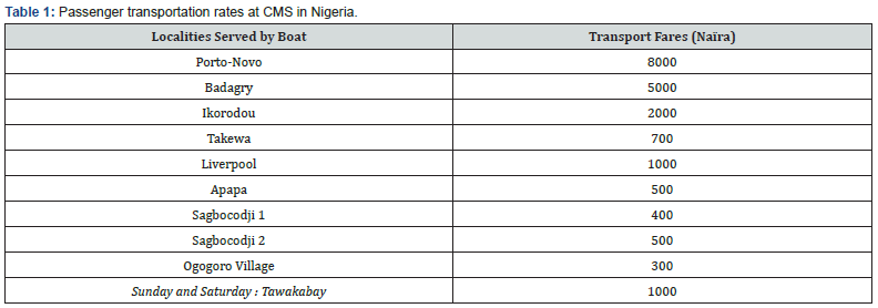
Source: National Inland Waterways Authority (CMS), 07/14/2023 in Lagos (Nigeria).
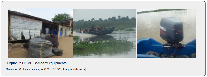
This figure shows the headquarters of Only God Marine Service, a 150HP Yamaha outboard engine, a boat heading to Lagos and the invasive plant areas on the lagoon, which makes navigation difficult or impossible in bad weather.
As a result, the fare per passenger from Porto-Novo to Lagos is set at 5,000 Naira, i.e. 5,000 CFA francs or 8 EUR, payable in both currencies. These rates are required due to the numerous fees paid on the road at each checkpoint (police, customs, gendarmerie, health and hygiene service). In case a passenger is transporting prohibited goods like pharmaceuticals from Nigeria to imported rice and vegetable oils, he or she pays more for the goods due to the risk of boarding. Prices are also revised upwards when the official borders between the two countries are closed. At the moment, their Nigerian partners are quickly relaying information to quickly adapt to the new situation. Throughout the route, agents at checkpoints are demanding more money in terms of illicit collections. But like any activity, there are fluctuations in traffic. Consultation seasons correspond to the times of end-ofyear holidays, religious festivals and border closures, with around 7 trips/day in both directions (252pax), i.e. monthly traffic of around 7560pax for “Only God.” Lean periods correspond to those of rising fuel prices as currently, rising costs of the Naira and political instabilities such as during elections, so on average 3 trips/day (108pax), i.e. monthly traffic of ‘around 3240 pax for “Only God”. With the hypothesis that the “Only God” consortium accounts for 50% of the total traffic on the Cotonou-Porto-Novo- Lagos route and that there are 6 months of high season and 6 months of low season in the year, we get an average annual traffic of 129,600pax. We could deduce an annual passenger turnover of approximately 648,000,000 F CFA or 1,036,800 EUR. Efforts to obtain official freight freight statistics have been unsuccessful.
However, our field observations combined with interviews with the various stakeholders allow us to postulate that freight transport is more important and fuels cross-border smuggling between the two countries and can be estimated in value at double that of passenger freight. The total annual turnover (tax and freight) could be around 2 billion CFA francs or 3.5 million EUR, which would have motivated the recent establishment of a customs service post at Maria-Tokpa.of the management documents of the company “Only God” shows over a quarter (March to May 2023) an average monthly traffic of 550pax. It should be noted that these records are not maintained rigorously without concealing maneuvers to underestimate traffic in order to minimize tax obligations. As a result, the interviews with the different actors revealed two periods of trafficking to consider. The high However, this thriving activity encounters dysfunctions that need to be corrected [13] for optimal, sustainable and resilient operation. This essentially concerns the permanent fight against invasive plant species (water hyacinth), dredging to improve the depth and marking on the Beninese side and technical obstacles to traffic at the checkpoints (5 Naïra in level of each station and approximately 1min) (Figure 8).
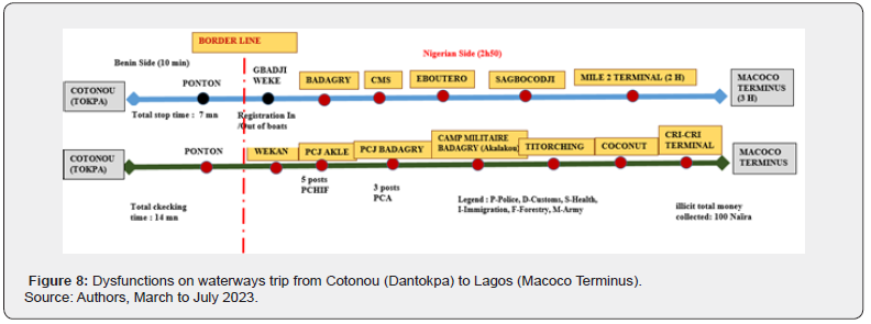
It shows the checkpoints and illicit collections at the different checkpoints from Cotonou to Lagos and the consequent loss of time.
Future development of waterways transportation in South Benin
The possibilities to develop waterways in south Benin are enormous to promote economically sustainable and resilient exploitation of waterways transportion in this country. These solutions concern the organization of passenger transport in view of the numerous advantages observed on the Porto-Novo to Lagos, the establishment following the potential location of a river terminal and the modernization of shipbuilding in Benin.
Professionalization and development of waterways transportation : towards an efficient, sustainable and resilient mobilities model
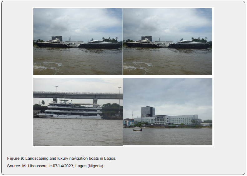
The dysfunctions in waterway passenger transportation observed and exposed above cannot in anyway erase its multiple advantages including low pollution, speed, lower cost, less congestion. Hence the urgent need to build mechanisms for its professionalization and promotion. The two-hour river journey time between Cotonou and Mile 2 Terminal is well below the road journey time which can take a whole day and worse up to Macoco Terminus given the heavy road congestion. For the movement of people and goods in the Lagos metropolis, there is an urgent need to transfer traffic from the road to the waterway. We can understand the river mobility habits of part of the population of Lagos which justify the importance of the navigation devices encountered in an area of concentration of the most powerful Nigerian companies in Lagos such as Bercy in Paris (pinasses, yachts and boats, pleasure boating) including that of the powerful Nigerian businessman Aliko Dangote. The real estate developments and constructions also command admiration. The Figure 9 shows these luxurious river navigation machines and some buildings erected on the banks of the lagoon to enhance the waterfront.
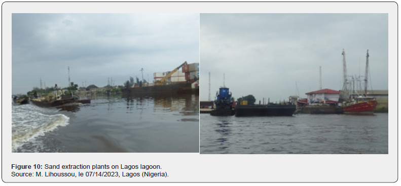
In the south of Benin, the interurban mobility plan must promote river traffic between the cities of Big Nokoué (Cotonou, Abomey-Calavi and Porto-Novo) to relieve permanently congested roads as is also the case in Abidjan in the Côte d’Ivoire. ‘Ivory. To achieve this, it would be necessary to ensure regular dredging to improve the bathymetry and extract the sand which will facilitate new real estate developments on the banks and the revival of urban real estate, mark the navigation routes on these bodies of water, build piers / landing stages along bodies of water and support artisanal shipbuilding in order to develop it. The Figure 10 shows sand extraction units to improve depth, fill in shallows and build new cities in Lagos.
One of the major challenges is therefore the professionalization of the different actors involved in river transport through various training courses such as the management of a transport company, tourism marketing, safety measures in navigation, logistics optimization, the economy and transport planning to support public investments in this sector of activity. The five criteria of Claude COMTOIS [12] combined, we could confirm that this waterways corridor is a major axis of mobility of people and goods between Benin and Nigeria.
Potential location and establishment of waterway terminal in Zangnanando
Messan LIHOUSSOU [14] already envisaged the river connection of the port of Cotonou with its hinterland to improve its competitiveness [3] but quickly encountered the technical obstacle of the three different poorly sized traffic bridges at the level of the channel. Circumventing such an obstacle should involve their demolition and the construction of movable bridges as is the case, for example, at the port of Antwerp : a heavy financial investment that Benin’s budget cannot support for the moment in view of many development priorities. A multimodal rail-road solution was then proposed and would allow very significant savings [15]. This contribution resurrects this possibility without currently considering passing entire ships from the port of Cotonou (PAC) or directly from the harbor to an inland terminal, but ensuring the Port-Inland Fluvial Terminal (TFI) connection by barges for containerized goods as is the case in Lagos between the ports of Tican Island and Apapa then terminals such as Mile 2 (Ro- Ro from Grimaldi), Diga, Idjègoun (first terminal installed on the Lagos lagoon) (Figure 11), Cri-Cri or RMAS in front of Tican Island Port and large motorized boats called “dady” for bulks.
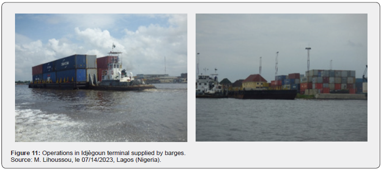
The pictures of this Figure 11 shows a barge transporting 24 TEUs1 to the Idjègoun terminal and the loading/unloading dock at this platform. This PAC-TFI barge connection will contribute to sustainable and economic development because a barge transporting 24 TEUs is the equivalent of 12 trucks loaded with 2 TEUs each. The deployment of 10 barges would avoid lining up 120 trucks on the road which would be very relieved [3].
The down Ouémé valley is a very interesting river corridor in the port and interior hinterland relationship. The river benefits from the contributions of other water courses which allow it to have permanent water in its basin. These contributions come from the Zou River in the West which has its source in North Togo and joins the Ouémé in the locality of Gangban, commune of Bonou. At the same time, it benefits from the waters of the Okpara River in the East which, along the Beninese borders for 156km from the North-East of Parakou, swells the Ouémé at Okpa hamlet in the locality of Bétékoukou (commune of Dassa- Zoume).
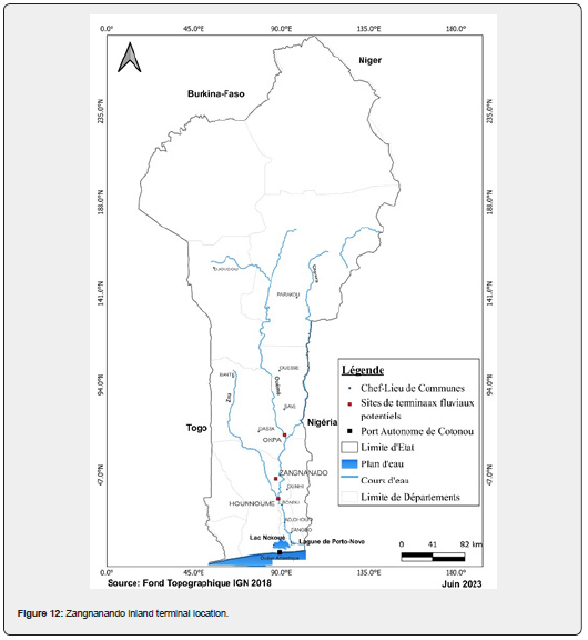
Thus, the down Ouémé valley has potential water resources with a bathymetry by survey, which varied in places between 2 and 3.5 meters. Nowadays, this bathymetry is well beyond these indicated values because of human activities of extraction of river sand in the major bed of the river. Since 2008, several sand quarries have been open along the river, allowing local populations to complete their traditional activities of fishing, agriculture and the transport of goods along the river. It must be recognized that this reach of the Ouémé River covers six rural communes: Zangnanando, Ouinhi, Bonou, Adjohoun, Dangbo and Aguégués, point of contact of the river, the lake and the Porto- Novo lagoon commonly called Lagos lagoon. This point serves as an outlet for the river, made up of several navigable channels. This navigability of the down side of Ouémé valley would respond to this corridor composed of a set : Port – Channel – Lake – River. It will be able to support any boat (midboat, pusher boat, pinnace, barge) with a shallow draft that can circulate between the port of Cotonou and the interior of the country. Thus, part of the cement produced in the commune of Sèmè-Kpodji and the products of the Cotonou brewery can be distributed in the territory via the river port of Zangnanando. In the same way, part of the traffic between the port of Cotonou and its hinterland could be transported by barges and “Daddy” boats towards the hinterland of the port of Cotonou. This down valley offers a corridor capable of having a river port and potential sites identified to house river terminals, it is the commune of Zangnanando which justifies an optimal location with regard to the natural possibilities of navigability on the Ouémé river (Figure 12 below).
1Twenty-Feet Equivalent Units.
Messan Lihoussou & Sabine Limbourg [15] showed a saving of 112 million euros and a modal transfer of 53% of traffic from road to rail for a multimodal rail-road solution. The opening of waterway terminal should improve this economy and relieve congestion on the road. The competitiveness of the port of Cotonou would gain enormously through the reduction of total transport costs, transit times and hassle. The ideal is to consider the extension of this river route and a rail relay. This waterway corridor would relieve rural populations in the transfer of goods from the various municipalities in the South-East of Benin which supply some markets in the South with sweet potatoes, leafy vegetables, fruit and poultry. It would be the central river corridor of Benin due to its contribution to the animation of the markets of the cities of Cotonou and Porto-Novo. It would be the first riverlacustrine corridor participating in the transfer of containerized goods from the port of Cotonou to the interior of the country through this inland river port [16-21].
Conclusion
The rivers in the south of Benin offer significant opportunities that have until now been underexploited. This contribution sheds light on some of them in order to motivate their optimal exploitation. Indeed, faced with increasingly crucial road congestion on the roads of Big Nokoué (Abomey-Calavi, Cotonou and Porto-Novo cities), it is urgent to promote waterways mobilities to relieve the road. In addition to providing fishery products which contribute substantially to countering food insecurity in Benin, these natural resources can also contribute to improving the performance of the port of Cotonou thanks to the establishment of a river terminal in Zangnanando. The riverlagoon and lake corridor of Benin has a potential that does not require significant developments to be viable. To breathe new life into the waterways areas of South Benin, the government expects to invest in the dredging of lake and lagoon beds, the rehabilitation of lagoon banks and the construction of lagoon tourist areas. The “reinventing Ganvié” project actually resonates as one of the priorities of the Beninese government to reveal Benin’s tourism potential.
Beyond national policies, the Cotonou-Lagos lagoon corridor which supports exchanges between Benin and Nigeria presents itself as a real instrument of cooperation and integration between these two States, a sustainable tool for the fertility of the territories crossed and Improvement in logistics fluidity, which is very essential to economic growth. This corridor is recognized as a major axis for the mobility of people and goods.
However, the challenges linked to the realization of the planned development plans, the professionalization of river transport players, the financial support and adequate training of traditional fisheries, the strengthening of the capacities of artisan builders for the modernization of navigation equipment manufacturing units. The water bodies of Southern Benin are just waiting for large-scale investments to better contribute to the economic growth of the country. The biggest prospect is to provide it with territorial river ports which will offer opportunities to river-lagoon transport companies, people carriers and hinterland customers, the use of a new lagoon space for the exchange of goods from or to the port of Cotonou at competitive costs.
References
- Lihoussou M, Orou GS (2023) La performance des corridors au coeur du processus de retournement territorial : cas du corridor Cotonou-Niamey (Afrique de l’Ouest). Revue Espace Géographique et Société Marocaine 69 : 43-67.
- Steck B (2013) Transport et développement des territoires : Editorial. Géotransports 1-2 : 5-14.
- Tilly P (2016) Conclusions : le transport fluvial au cœur des préoccupations et des enjeux contemporains. Revue belge de philologie et d'histoire, tome 94, fasc. 4. Histoire médiévale, moderne et contemporaine, pp. 1029-1041.
- Savadogo I, Gardrat M, Koning M (2023) Environmental and economic evaluation of a low emission zone for urban freight transport. Research in Transportation Economics 102: 101369.
- Dicko HA (2022) Contribution des corridors de transports fluviaux au désenclavement du Sahel : cas du fleuve Sénégal, d’Ambededi à Saint-Louis du Sénégal. In : Lihoussou M, Bopda A (Eds.), Innovations dans la gestion des ports et des corridors logistiques en Afrique Atlantique, Coll. Afrique Atlantique, tome 7, Le Havre, Éditions EMS, pp. 111-136
- Abeloko S (2020) Transport fluvial : la solution aux nouveaux enjeux logistiques de l’Afrique de l’Ouest et du Centre. Communication introductive au webinaire du Cluster Maritime d’Afrique Francophone.
- Lihoussou M (2016) Quel avenir pour le transport maritime régional en Afrique de l’Ouest ? In : Serry A, Lévêque L (Eds.), Le transport maritime sur courte distance, Actes de colloque international Devport, 19 au 21 mai à l’Université du Havre, édition EMS, pp. 303-317.
- Lihoussou M, Bopda A (2022) Innovations dans la gestion des ports et des corridors logistiques en Afrique Atlantique, Coll. Afrique Atlantique, tome 7, Le Havre, Éditions EMS, p. 241.
- SOSSOU-AGBO A. Lazare (2018) Téléphonie mobile et gestion du transport fluvio-lagunaire au Bénin. In: Lihoussou M, Steck B (Eds.), Moderniser les ports ouest-africains : enjeux et perspectives, Coll. Afrique Atlantique, Le Havre, Éditions EMS, pp. 247-261.
- Lihoussou M (2014a) La compétition portuaire pour la desserte des territoires enclavés. Le cas de Cotonou (Bénin). Géotransports 4: 99-116.
- Lombard J, Ninot O (2013) Des axes et des pôles. Corridors ouest-africains et développement territorial au Mali. Géotransports, Transport et développement des territoires 1-2: 191-204.
- Comtois C (2012) Définition et périmètre des grands corridors de transport fluvio-maritime. In: Alix Y (Ed.), Les corridors de transport. Coll. Les Océanides, éditions EMS Management & Société, Le Havre, pp. 65-86.
- Lihoussou M (2017) Dysfonctionnements et entraves à la circulation en Afrique de l’Ouest : l’exemple du corridor Abidjan-Cotonou. In : Benjamin Steck (Ed.), Pour une Afrique fluide, revue Les Cahiers Scientifiques du Transport 72: 43-66.
- Lihoussou M (2014b) Ports et désenclavement territorial : cas de l’arrière-pays du port de Cotonou, thèse de doctorat en géographie des transports, spécialité : Transport et Logistique, université du Havre, p. 466.
- Lihoussou M, Limbourg S (2017) Rail-road terminals location with interconnected rail network of West African Countries. In: Limbourg S, Cools M (Eds.), Towards an autonomous and interconnected transport future. BIVEC/GIBET Transport Research Days 2017 Proceedings, Liège, pp. 397-401.
- AFD (2018) Réinventer Ganvié, p. 260.
- Dicko HA (2023) La construction navale et le développement durable au Mali. Communication orale lors du colloque international sur « la construction navale au Mali » du 10 au 12 mai 2023 à Bamako (Mali).
- ONU-CEE (2020) Livre blanc sur les progrès, les succès et les perspectives de transport par voie navigable, Genève, p. 100.
- ONU, CES, CEE et CTI (1994) Base méthodologique pour la définition de critère communs concernant les goulots d'étranglement, les liaisons manquantes et le niveau de services sur les réseaux d'infrastructures, p. 69.
- Pascal L (2012) Gestion des frontières, enjeux douaniers et corridors de transport : retours d'expériences douanières. In: Alix Y (Ed.), Les corridors de transport. Coll. Les Océanides, éditions EMS Management & Société, Le Havre, Editions EMS, pp. 183-199.
- Verny J (2012) Les corridors de transport : objets en faveur d'une mobilité durable? In: Alix Y (Ed.), Les corridors de transport. Coll. Les Océanides, éditions EMS Management & Société, Le Havre, Éditions EMS, pp. 323-335.


