Bibliometric Analysis and Review of Recent Literature on Flood Susceptibility and Trends in Forecasting Methods
Prerak Pathak1* and K Muralidharan2
1 Department of Environmental Studies, The Maharaja Sayajorao University of Baroda, India
2 Department of Statistics, The Maharaja Sayajirao University of Baroda, India
Submission: May 19, 2023; Published: June 07, 2023
*Corresponding author: Prerak Pathak, Department of Environmental Studies, Faculty of Science, The Maharaja Sayajirao University of Baroda, Vadodara, Gujarat (390002), India,
How to cite this article: Prerak Pathak, K Muralidharan. Bibliometric Analysis and Review of Recent Literature on Flood Susceptibility and Trends in Forecasting Methods. Int J Environ Sci Nat Res. 2023; 32(2): 556337. DOI 10.19080/IJESNR.2023.32.556337
Abstract
Global environmental issues like Climate change has contributed to the increased frequencies and intensity of hydrological disasters like floods. Using a bibliometric methodology, this article presents a comprehensive analysis of flood susceptibility and forecasting. The study investigates the historical trends and patterns of research on flood susceptibility and forecasting. The analysis examines a variety of factors, such as the number of publications, countries, institutions, and journals that have made contributions to this field. The study emphasizes the significance of flood susceptibility and forecasting as essential elements of disaster management and the need for sustained research in this field. In addition, the article examines the publications by various authors on statistical, spatial, and machine-learning approaches utilized in flood susceptibility and forecasting. The conclusion of the article identifies research gaps and prospective directions for research on flood susceptibility and forecasting.
Keywords: Bibliometric; Flood susceptibility; Forecasting; GIS; Statistical analysis; Machine learning
Introduction
Several environmental challenges are being witnessed by people globally. Most of these challenges are rooted in our resource-intensive urban lifestyle. Some of these challenges are reversible and some are irreversible like Climate change. As a consequence of human-caused Greenhouse Gas (GHG) emissions, both biotic and abiotic components of natural ecosystems are under growing stress [1]. A number of the recent natural disasters may be traced back to a modification or shift in the climate of the entire planet. The term "flood" refers to a type of hydro-meteorological disaster that occurs when an abnormally large volume of water suddenly covers a portion of land that is not typically submerged in water within a relatively short length of time. Floods are a major contributor to the destruction of property, the loss of biodiversity, and the loss of human lives. Rainfall totals that are excessive, together with subsequent runoff volumes that are greater than the carrying capacities of natural channels and borders, are the root causes of floods. Heavy precipitation and surface runoff are the main hydrological processes that are considered in watershed management planning [2]. As a result of climate change, floods have gotten significantly more severe and have occurred with greater frequency all around the world [3]. In India, an area of around 40 million hectares has been identified as flood-prone area [4]. The world, including India, has witnessed some of the deadliest hydro-meteorological disasters including floods since the year 2019 [5]. The recent report on mortal losses from disasters caused by natural hazards, grounded on the EM- DAT data from 2000 to 2019 [6] includes flooding within the hydrological hazards- type, along with landslides and surge action. Several approaches are grounded on the traditional and current understanding of the threat conception [7] and define the threat as a product of hazard, exposure, and vulnerability. Other methods conduct a statistical analysis of the patterns of flood tide damages, as well as the characteristics of the hazard and the exposure [8]. Flood susceptibility analysis and the prognosis of such disasters can help us in explaining damage patterns, population exposures, and other risk patterns in the region [9]. Hence, governments are trying to develop reliable maps and models of flood risk areas and plans for sustainable flood risk management focusing on prevention, mitigation, and preparedness [10]. For hazard vulnerability assessment and severe event management, flood prediction and simulation models are of critical relevance. Accurate and authentic models for predictions can contribute highly to water resource management strategies, policy-making, and further mitigation planning [11]. Hence, it is important to use advanced modelling systems for a short and long-term prognosis for floods and other hydro-meteorological events to reduce the extent of damage [12]. Currently, there are so many watershed models available to predict different hydrological events [13-15]. However, it is complex to predict the flood lead time and occurrence location due to the dynamic climate system. Important elements to take into account are the amount of data required, how user-friendly the system is, and the number of resources needed. Different researchers have identified different methods and techniques to prepare a model that can predict flood events in their respective study locations in the short-term and long-term future. Some of the methods are based on Geographical Information System (GIS), some are solely based on statistical analysis, and some are physically based models or Artificial Intelligence/Machine Learning (AI-ML). To make the predictions and analysis more accurate, researchers have tried to develop hybrid models. GIS and statistical hybrid models can predict hydro-meteorological disasters such as urban floods more effectively [16]. GIS and Remote sensing methodologies have been used to predict flood-prone areas and the extent of floods for a long time. A significant number of approaches to flood hazard mapping utilize Digital Elevation Modelling (DEM), water discharge data, and flood frequency data such as remote sensing, GIS, and hydrological data [17]. However, traditional techniques to predict such high-intensity hydrological disasters have some limitations regarding data and variables like precipitation and flow levels [18]. Thus, so many hybrid approaches have been introduced to increase the accuracy of the models. Such hybrid models include climatic data, topographic and elevation data, land use (LU) and proximity information, the artificial neural network (ANN), and logistic regression (LR) models [19]. Such hybrid models of ML techniques and GIS can also be utilized for urban management and planning concerning climate resiliency. This method can identify practical contributing factors and risk indices for the occurrence of floods at the municipal level, which can be important for outlining a long-term Smart Cities plan [20].
The major flood modelling systems that are available today are data-specific and they involve various simplified assumptions [21]. Thus, newly invented techniques like Artificial Intelligence and Machine Learning are important techniques to predict hydrological as well as hydro-meteorological events for dendritic watershed systems. Some models were used to predict hydrological processes of extreme weather events like run-off of rainwater during storms and cyclones [22-25], hydraulic models of flow [23,26], global circulation [27], shallow water conditions [28]. Physical based models show high capabilities for predicting flood scenarios. Although physical models demonstrated significant skills for forecasting a broad variety of flooding scenarios, they frequently require various forms of hydro-geomorphological monitoring information. This necessitates costly computing, which prevents short-term prediction from being possible [29]. In addition, the construction, training, and validation of such models sometimes demand in-depth knowledge and experience related to hydrological as well as climatic parameters, which has been noted to be a very difficult task mentioned by Kim et al. [30]. Furthermore, several studies point to a gap in the efficiency of short-term prediction of physical models [31]. As an illustration, such models were frequently incapable of making accurate forecasts. In their research, Van den Honert & McAnerney [32] studied the failure of flood forecasting that occurred in Queensland, Australia in the year 2011. In a similar vein, numerical prediction models were described in the development of deterministic computations; nevertheless, these models lacked dependability due to the presence of systematic errors [33,34]. Despite this, it was stated not too long ago that physically based flood models have lately seen significant advancements due to the hybridization of models [35] and more powerful flow simulations [36,37]. Recently, a considerable amount of studies have been carried out on the prognosis of severe hydro-meteorological events using hybrid models which are more efficient and powerful towards long-term predictions.
Methodology and Data Collection
Bibliometric analysis is effective for tracing the evolution of a research area and identifying research hotspots. It quickly identifies the coupling relationship between published articles and the cooperation relationship between authors because it combines mathematics, statistics, and philology to assist researchers in conducting quantitative analysis and visual research on literature. It allows us to explore the subtle evolutionary aspects of a particular discipline while illuminating its frontiers. The most prevalent methods of analysis are core author analysis, co-citation analysis, and co-word analysis.
For this study, research articles and research papers related to flood predictions were searched and collected from the Web of Science portal's core collection database. The database was searched through keywords such as, "Flood predictions using GIS tools", "Flood predictions through statistical analysis", "Flood predictions by AI-ML" and "Flood predictions through hybrid models of ML" and sorted the database for literature types- Articles, papers, and review. Through this, we collected a dataset of 1389 research papers from the period of 1999 (January)-2023 (March). We then sorted all the papers based on their relevance to the research topic. After the final sorting and filtering process, 769 papers remained.
A detailed bibliometric analysis has shown further in the third section along with different cooperation networks and co-citation networks. Different techniques and sources have been discussed in different sub-sections. In fourth section, a technical review is presented in terms of advanced hybrid models and methodologies used in different hydrological processes like Rainfall-runoff analysis and flood susceptibility modelling. The review concludes with further research directions and limitations of using different advanced modelling technologies in this field.
Research on the Overall Flood Prediction
Flood predictions using geographical information system (GIS)
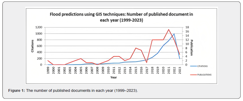
The number of publications and citations in a field can indicate the level of scholarly interest in that area. Figure 1 shows that the literature on flood prognosis through GIS technologies has gradually increased since 2002 and has shown exponential growth after the year 2008. The literature related to flood prediction using Geographical Information System is highest in the year 2021 with 17 documents published in a single year.
The figure also shows the changing trends in the number of citations in different documents for the prediction of floods using recent and advanced technologies during the past 2.5 decades. The number of citations grew from 1 in 1999 to 993 in the year of 2022. Even in the year 2023, 193 citations have been observed till March. The most cited article is Tehrani’s article (2015) on flood susceptibility assessment using GIS-based support vector machine models with different kernel types. This article has been cited 384 times with a mean citation value of 42.67 per year. This study was done based on different physical, geographical, and geological parameters and assessed through a support vector machine (SVM) model. This study has been a foundation research in the field of Flood prognosis through GIS and modelling.
Flood predictions using statistical analysis
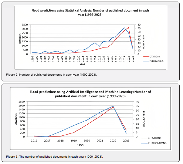
Figure 2 demonstrates how the amount of research on flood prognosis using Statistical analysis and modelling has grown steadily since 2006 and exponentially since 2009. The number of publications for the literature on flood prediction using Statistical Analysis peaks in 2021 with 72 documents. The chart also displays the shifting patterns of the number of citations in various texts for flood prediction employing cutting-edge technologies during the previous 24 years. The number of citations has increased from 5 in 1999 to 3180 in 2022. Up until March of the year 2023, 675 citations have been recorded. This shows high demand for statistical Analysis in the field of disaster susceptibility modelling and disaster mitigation research. Tehrani’s article [38] on Flood susceptibility mapping using a novel ensemble weights-of-evidence and support vector machine models in GIS has been cited the most with a total of 499 citations and an average of 49.9 citations per year. In this study, the weights-of-evidence model (WoE) was initially applied to evaluate the effects of classes of each conditioning component on floods using bivariate statistical analysis (BSA). To assess the link between the likelihood of a flood occurring and each conditioning element, these factors were categorized using the acquired weights and added to the support vector machine (SVM) model.
Flood predictions using artificial intelligence and machine learning (AI-ML) technologies
Artificial intelligence and machine learning are relatively advanced technologies, and their use in flood prognosis just recently became popular. Figure 3 shows the number of publications and citations in the field of flood forecasting during the last 7 years i.e., from 2016 (January) to 2023 (March). The publications have exponentially increased after the year 2017. The highest number of publications can be observed during the year 2022 with 35 publications. Given the importance of such advanced technology in disaster vulnerability assessment and mitigation research, the number of citations has risen dramatically since 2018. The highest citation was recorded in the year 2022 with 1529 citations. Mosavi’s [39] review article on flood predictions using Machine learning models has been cited the most with 490 citations in total and an average of 81.67 citations per year. This article reviews most of the research works in the field of flood prediction using physically based models as well as AI-ML techniques. The intense literature survey mentions limitations and gaps in different models which is important for further planning of such research works. This review has served as a foundation for future research in the field of flood prediction utilizing AI-ML technology.
Major research areas of the publication
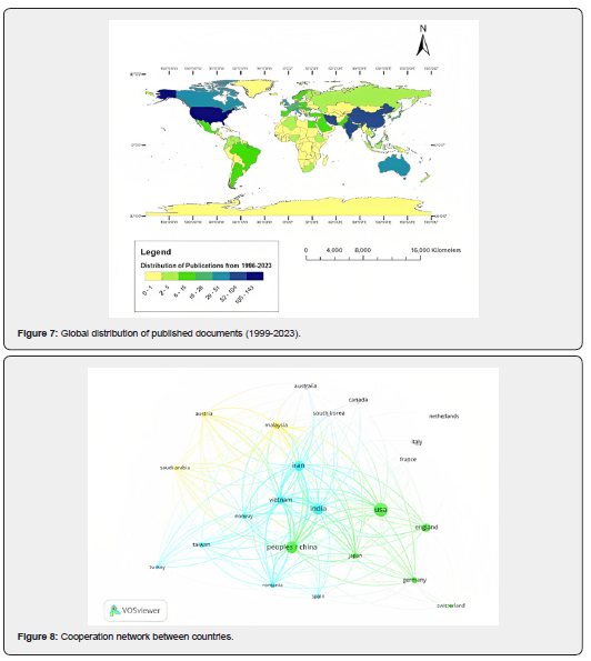
Figure 4 displays the primary flood prediction research topics and their relative weights. The Web of Science database directs the flow of the research. It is evident that most of the study is focused on water resources, Environmental science, ecology, and geology, with a small amount of research concentrating on theoretical sciences.
Analysis of resources/journals
Figure 5 shows the number of documents published by a source or journal. The maximum number of research documents was published by the Journal of Hydrology with 46 articles about flood susceptibility and prognosis in different regions, followed by Water and Natural Hazards with 35 and 19 research publications respectively. These journals have a high number of citations and they form internal cooperation networks of citations with each other. This cooperation network of top journals is illustrated in Figure 6. Journal of Hydrology forms a large network with all the top journals and offers fundamental research documentation in the study field. Followed by Water and the Science of the Total environment.

Publication countries
Figure 7 shows the distribution of publications related to the prediction of a flood using different methodologies. A list was collected from the Web of Science (WoS) regarding countries of research. From this database, a map was prepared in ArcGIS. The map clearly shows that the United States of America has the greatest number of publications (143), followed by India (104) and the People's Republic of China/PRC (84). African countries have the least amount of published documents on this subject; however some African countries hit catastrophic flash floods almost every year which affects millions of people in those regions [40]. Researchers in these regions have focused more on the case studies of past flood events and trends of the flood occurrence.
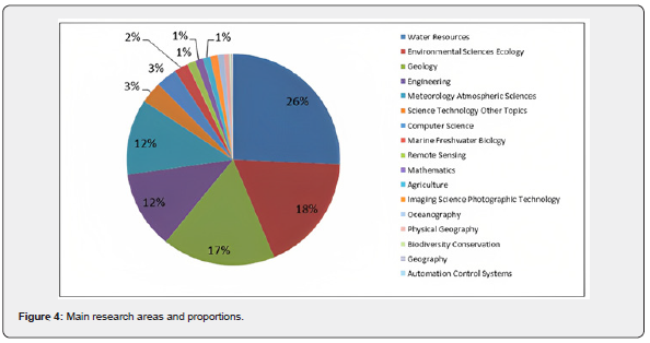
Figure 8 shows bibliometric network visualization for the distribution of citations in different regions. The cooperation network shows 4 different clusters, each illustrating citations of documents from different countries and regions. USA, India, and China have offered a vast network of citations to other countries and regions in the field of Flood prognosis. These are also the countries with the highest number of publications. Thus, it can be inferred that these countries have done a considerable amount of quality research work which has served as a foundation for Disaster Mitigation and climate resilience studies. These are also the regions where floods are a huge threat to the living population as well as biodiversity. More than 20 million people are getting affected due to different types of a flood each year in these three countries. Hence, a high number of publications on Hydrological disaster mitigation from these regions can be justified.
Analysis of high-level scientific research institutions
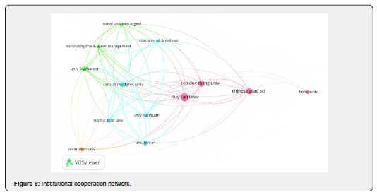
The top 10 journals in the field of flood susceptibility analysis and forecasting research are shown in Table 1 along with their main areas of publication. The Duy Tan University, which has published 25 articles overall, is the leading organization with the highest publication record in the field. Affiliations from Vietnam, China, and India are more focused on flood susceptibility analysis and mitigation studies. These tropical and subtropical countries witness different types of floods every year. The intensity of floods has increased in recent years and so do the fatalities. All the institutes and organizations have mainly focused on newly discovered advanced technologies like GIS and Machine learning for their studies.
Additionally, in Figure 9, we can see how these top ten institutions along with some other renowned affiliations work together effectively. Duy Tan University, Ton Duc Thang University, and The Chinese Academy of Sciences act as the hub of the current research's cooperating network. Maximum citation networks are formed by these 3 universities. Duy Tan University has formed a strong cooperative network with other universities of the same regions like Ton Duc Thang University and forms a cluster.
Another cluster network was formed by The University of Bucharest and Tarbiat Modares University which form strong cooperative networks in their respective regions. Comparing the data of Table 1 & Figure 9, some affiliations like IIT and CNR which have a good amount of publications in this field, could not form a strong network in their respective regions. This also depicts a major research gap in these regions.
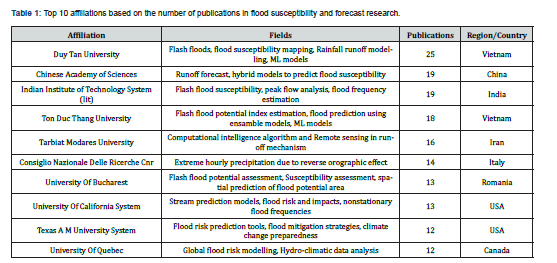
Analysis of authors and their highest cited publications
Table 2 shows the information about the top ten authors with the highest publications along with the documents that were cited the most. The research paper entitled, "A comparative assessment of decision trees algorithms for flash flood susceptibility modelling at Haraz watershed, northern Iran" has 353 citations which are highest among the other papers' citation ranks. 4 authors of this research paper, viz, Bui DT, Pham BT, Shahabi H, and Shirzadi A are also in this list of top ten authors who have published a considerable number of publications on Flood susceptibility and prognosis. Researchers evaluated four decision tree-based machine learning models for mapping the vulnerability to flash floods at the Haraz Watershed in northern Iran. These models were, Logistic Model Trees (LMT), Reduced Error Pruning Trees (REPT), Naive Bayes Trees (NBT), and Alternating Decision Trees (ADT). These methods are effective at identifying flood-prone locations.
Keywords co-occurrence analysis
To investigate the keywords co-occurrence network relevant to the research topic, a keyword density diagram is shown in Figure 10 based on the number of associations and the intensity of their relationships. Keywords like Machine learning, GIS, and Flood susceptibility have a large occurrence density. The research documents were chosen based on different methodologies to forecast flood and flood susceptibility thus the high density of such keywords depicting different techniques is explainable.
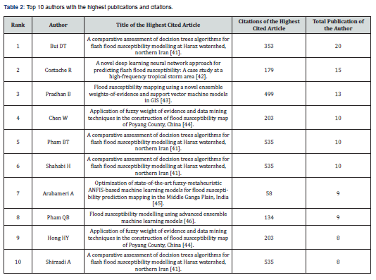
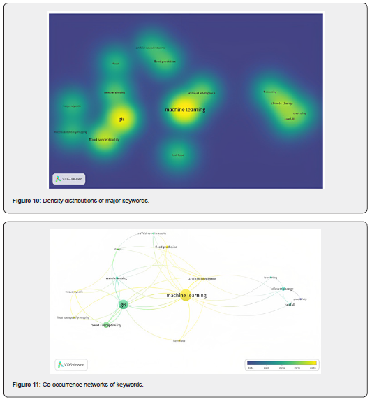
Figure 11 shows the co-occurrence network of these keywords during different periods in different documents related to flood prognosis. Here, Artificial Intelligence, ANN, and Machine Learning form a distinct cluster which shows these keywords were used in the documents which were published later after 2016. These techniques are quite new yet the co-occurrence of these words is high. Thus, we can infer that these are the techniques that are of more interest to the current authors and researchers. Also, these techniques are quite important in the field of flood predictions and disaster vulnerability assessment.
Through the bibliometric analysis, we have a wide range of datasets regarding top journals, pioneer institutes working in the field of flood susceptibility analysis and prediction sciences, highest cited documents and articles, authors with highest publication records and advanced technologies and models used by different researchers for different purposes. Further in the next section, a more technical review is given with respect to different methods used by different researchers and authors along with their limitations and research gaps.
Technical Review of Related Literature
It makes more sense to offer a comprehensive analysis on the basis of the bibliometric analysis, focusing on many approaches to research and writing employed by various authors and researchers, as well as the limitations and unanswered questions posed by those approaches. In recent years, the majority of authors have been concentrating their efforts on developing hybrid models that combine Artificial Intelligence and Machine Learning in order to analyse, investigate, and evaluate flood-prone locations as well as the intensity of floods along with short-term and long-term predictions.
The issue of urban flooding, which is a major worry in many cities throughout the world, is discussed in the article written by Motta et al. [20]. To forecast urban floods, the authors suggest a mixed methodology that incorporates machine learning and geographic information systems (GIS) rather than using only GIS methods. The hybrid method is tested on a case study of a flood-prone region in Brazil, and the results demonstrate that it is capable of making precise predictions about the frequency and intensity of floods. The study proposes an innovative approach that combines two potent technologies, machine learning and GIS, to increase the accuracy of flood predictions, which is a significant contribution to the field of urban flood prediction. As GIS enables the integration of many sorts of data such as topography elevation, land use, and rainfall intensity, the study also sheds light on the significance of adding spatial data into flood prediction models. The study does have certain restrictions, though. The study only employed a small number of variables; future research may look into using more variables to increase the precision of flood predictions. Finally, because the study concentrated on short-term flood prediction, future research might look into how the mixed approach might be utilised to assess the risk of long-term flooding.
Le et al. [47] examines flood forecasting using LSTM neural networks. South Korean river rainfall and water level data are used to create LSTM flood prediction models. LSTM models are compared to ANNs and SVMs. LSTM models exceed classic machine learning methods in accuracy and performance. For flood forecasting, LSTM models can incorporate data temporal dependencies, as shown in the study. In data with complicated temporal connections, LSTM models can predict floods, the scientists say. Despite the study's optimistic outcomes, research gaps remain. Firstly, the study only analyses data from one South Korean river, making it unclear if the conclusions can be applied elsewhere. Secondly, the study ignores meteorological and hydrological parameters that affect flood forecasting accuracy. Thirdly, the study ignores LSTM model drawbacks including over fitting and data requirements.
Till now many conventional methodologies have been used to make flood susceptibility maps, short-term and long-term prognosis of the hydro-meteorological disasters and to make a proper mitigation plan for the society. However, emerging technologies like Hybrid models, AI-ML and bivariate statistics are utilized by several researchers to prepare a proper Flood Susceptibility Map and to predict the events more accurately. In recent years, advanced technologies like Artificial Intelligence and Machine Learning models are being used to forecast the floods and related disasters. Different methods are discussed here.
Artificial neural network (ANN)
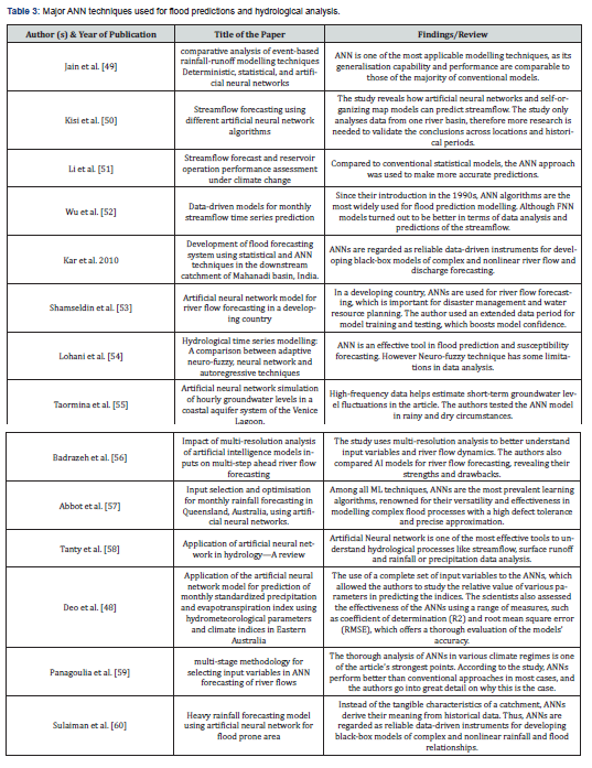
ANNs are efficient mathematical modelling systems with efficient parallel processing, allowing them to simulate biological neural networks with interconnected neuronal units. Among all the other AI-ML models, Artificial Neural Networks are quite popular to predict complex flood processes with an accurate approximation. There are a number of disadvantages related with the use of ANNs in flood modelling, such as the network architecture, data management, and physical interpretation of the modelled system. These disadvantages exist despite the fact that ANNs have a number of benefits. The use of artificial neural networks (ANNs) comes with a number of drawbacks, the most significant of which are the relatively low accuracy, the need for iterative parameter adjustment, and the delayed response to gradient-based learning processes [48]. A comprehensive review on major ANN techniques used for flood predictions and hydrological analysis is given in Table 3.
Multilayer perception (MLP)
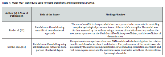
MLP is composed of densely interconnected layers that transform any input dimension into the desired dimension. A perception with multiple layers is a neural network with multiple layers. In order to construct a neural network, neurons are combined such that the outputs of some neurons serve as inputs for other neurons. MLP models were shown to be more successful and to have more generalizability than ANN classes that are used in flood modelling. This was discovered through an evaluation of ANN classes that are used in the modelling of floods. Nevertheless, the MLP is typically more challenging to optimise [61]. Table 4 summarises the major MLP techniques used for flood predictions and hydrological analysis.
Adaptive neuro-fuzzy inference system (ANFIS)
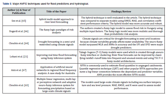
It is a qualitative modelling technique employing soft computing and natural language. Fuzzy logic is a mathematical paradigm that incorporates expert knowledge into a fuzzy inference system (FIS). An FIS further imitates human learning via a less complex approximation function, which has enormous potential for nonlinear modelling of extreme hydrological events [63,64]. Table 5 shows the development in ANFIS techniques used for flood predictions and other hydrological analysis.
Wavelet neural network (WNN)
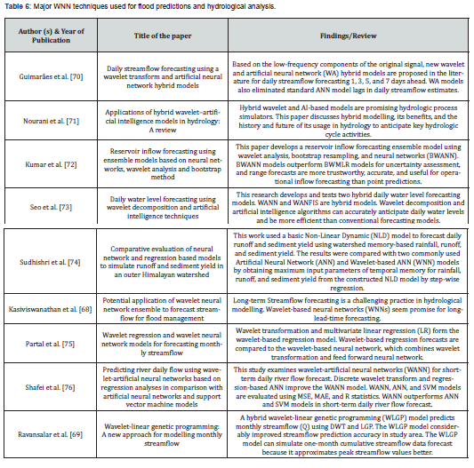
It is a mathematical method that can be used to extract information from a wide variety of data sources by doing an analysis of local variations in time series [68]. It is a hybrid tool of Wavelet Transform and Multilayer perceptron. In flood modelling, Decomposition of Wavelet Transform (DWT) can be widely applied for Rainfall Run-off analysis and prediction [69]. As shown in Table 6, Shafei et al. [76] have used Wavelet Neural Network techniques in river flow forecasting and other hydrological processes. They have also compared the performance of other models.
Support vector machine (SVM)
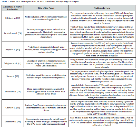
A support vector machine (SVM) is a type of algorithm for deep learning that performs supervised learning for data group classification or regression. In artificial intelligence and machine learning, supervised learning systems provide labelled input and output data for classification. SVM is quite popular modelling method of futuristic data analysis. Due to the heuristic and semi-black-box nature of SVMs, their high computational cost and exaggerated outputs may be problematic; however, the least-square support vector machine (LS-SVM) significantly improved performance with acceptable computational efficiency [77]. Table 7 shows major SVM techniques used for flood forecasting and other hydrological process analysis by different researchers along with the model limitations.
Decision tree (DT)
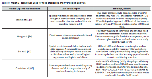
Predictive modelling and flood simulation use the DT ML approach. DT employs a decision tree from branches to leaf targets. Classification trees (CT) have discrete final variables, where leaves represent class labels and branches represent feature label combinations. Researchers compared the efficacy of ANN, SVM, and RF in general flood applications, with RF delivering the best results [42]. Major Decision Tree techniques and their limitations in flood forecasting and hydrological process analysis is mentioned further in Table 8.
Ensemble Prediction Systems (EPS)
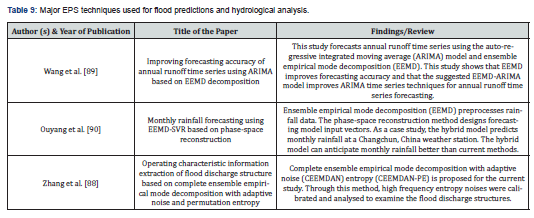
Machine learning and Artificial Intelligence techniques are widely used for different purposes. The practise of making predictions using only one model rather than a collection of models tailored to a certain dataset, cost, and application is becoming less common as a result of a developing strategy. ML ensembles are made up of a limited number of different models, each of which can often accommodate a greater degree of flexibility than the alternatives. Zhang et al. [88] reviewed several Ensemble Machine Learning methods that were used to analyse and examine hydrological events, mainly floods. The other major studies in this area are given in Table 9.
Mosavi et al. [39] offers a summary of many machine learning models that have been applied to the task of flood prediction. These models include artificial neural networks, support vector machines, decision trees, and genetic algorithms. The writers explore the benefits and drawbacks of each model, as well as present instances of how each might be applied in a variety of geographic locations around the world. Machine learning models have demonstrated promising results in flood prediction, particularly when compared to classical statistical models, which is one of the major findings of the paper. However, the authors point out that there are a number of obstacles and research voids that need to be filled in. For instance, constructing reliable flood prediction models is made significantly more difficult by the dearth of data of a high quality and the restricted availability of data sets that cover a lengthy period of time. In addition, the authors stress that there is a need for additional study on the transferability of machine learning models across different locations, as well as research on the integration of diverse models for more accurate predictions [91-94].
Conclusion and Future Research Directions
The field of disaster susceptibility analysis, Prediction of severe weather events, and mitigation strategies have attracted a lot of scholarly attention recently, with both the number of publications and citations rising sharply. In this study, 769 publications on this subject were examined using bibliometrics, and statistical analysis was utilized to determine that the majority of the articles in the field were published in scientific journals like the Journal of Hydrology, Water, and Natural Hazards. The highest amount of research has been done for flood susceptibility modelling through statistical analysis. Technologies like Machine learning and Artificial intelligence are comparatively new modelling systems yet the publications in this field have exponentially risen in recent years which shows the high demand for such advanced technologies in the field of disaster susceptibility and mitigation. Hybrid modelling technologies also have higher efficiency in flood forecasting. The United States, India, and China were the top three countries for research in this area based on the number of publications. Duy Tan University in Vietnam has published the highest number of research documents along with a large number of citation networks in the study area. Bui D. T., Costache R., Pradhan B., and Chen W. have all made noteworthy contributions, according to our analysis of the publication authors, as identified in our study. Through keyword analysis and cooperation networks, it is clear that areas like AI-ML, GIS, and Flood susceptibility are emerging topics in recent times. Technical review shows that methods like Artificial Neural Network, Support Vector System and Decision Tree turned out to be the best possible techniques in flood prediction and susceptibility modelling. The interpretability of the results is one of the areas where artificial intelligence algorithms fall short in the field of flood forecasting. It is possible for these models to be quite complicated, making it challenging to comprehend how they arrive at their conclusions and forecasts. The inability to interpret the outcomes of these models can make it difficult for decision-makers to make good use of the information provided by these models. Predictions made by models are subject to a degree of uncertainty since AI models are built on statistical approaches, which by their very nature involve some degree of randomness. This uncertainty can be caused by a wide number of factors, such as mistakes in the data, restrictions imposed by the model's algorithms, or variations in the values used to define the input parameters. When utilising these models for the purpose of flood forecasting, it is therefore vital to keep in mind the degree of uncertainty associated with the forecasts that are produced by the models.
Increased focus on the significance of such studies
Research on flood susceptibility and flood prediction studies are essential for a variety of reasons:
a) Risk Reduction: Flood susceptibility research and flood prediction studies can aid in the identification of high-risk areas for flooding. This data can be used to develop effective flood risk reduction strategies, such as the construction of flood defences and the creation of flood warning systems.
b) Disaster preparedness: Accurate flood forecasts can assist emergency management authorities in preparing for and responding to potential flooding occurrences. This may involve evacuating affected residents, mobilizing emergency responders and resources, and coordinating relief efforts.
c) Environmental Management: Research on flood susceptibility can assist in identifying areas that are particularly susceptible to flooding due to environmental factors such as soil type, topography, and land use. This information can be used to inform decisions regarding land-use planning and environmental management, such as where to locate new development or how to manage wetlands and floodplains.
d) Planning and Design of Infrastructure: Flood prediction studies can also inform infrastructure planning and design. For instance, engineers can use flood forecasts to design structures such as bridges, culverts, and dams that can withstand expected flood events.
e) Economic Impacts: Significant economic effects can result from flooding, including property and infrastructure damage, disruption of business and industry, and loss of productivity. Flood susceptibility research and flood prediction studies can help identify the most vulnerable areas, thereby mitigating their effects.
Method innovation and selection of advanced technologies
GIS (Geographic Information System) and AI-ML (Artificial Intelligence and Machine Learning) techniques can be used to enhance the accuracy and timeliness of flood warnings by incorporating them into flood forecasting. GIS techniques can be utilized to acquire, manage, and analyze vast amounts of spatial data, such as river networks, elevation, land use, soil moisture, and precipitation data. This information may serve as input for AI-ML models. GIS can be used to extract features such as slope, aspect, and land use from spatial data for use as input for AI-ML models. Using historical flood data, AI-ML models such as neural networks, decision trees, and random forests can be trained to predict future flood events. These models can be combined with GIS data to generate flood forecasts that are spatially explicit. In multiple methods, AI and ML can be utilized in flood forecasting. Developing models that use historical data on rainfall, water levels, and other relevant factors to predict the likelihood and severity of floods is one of the most common methods. Using machine learning algorithms, these models can be trained to increase their accuracy and dependability over time.
Hybrid models of GIS and Artificial Intelligence/Machine learning can show high efficiency in flood predictions. GIS can be used to incorporate real-time data such as rainfall and river flow data with AI-ML models to generate real-time updates to flood forecasts. Through maps and other graphical interfaces, GIS software can be used to visualize and communicate flood forecasts to decision-makers and the general public. Big data concept is one such unexplored area, where the researchers can throw more light on the development of related models in terms of flood forecasting and susceptibility mapping.
References
- Schnellnhuber HJ, Cramer WP (Eds.), (2006) Avoiding dangerous climate change. Cambridge University Press.
- Oleyiblo JO, Li ZJ (2010) Application of HEC-HMS for flood forecasting in Misai and Wanan catchments in China. Water Science and Engineering 3(1): 14-22.
- Nadeem MU, Waheed Z, Ghaffar AM, Javaid MM, Hamza A, et al. (2022) Application of HEC-HMS for flood forecasting in Hazara catchment Pakistan, south Asia. International Journal of Hydrology 6(1): 7-12.
- Singh O, Kumar M (2013) Flood events, fatalities and damages in India from 1978 to 2006. Natural Hazards 69(3): 1815-1834.
- Muralidharan K (2021) Sustainable Development and Quality of Life: Through Lean, Green and Clean Concepts. Springer Nature.
- CRED, UNDRR (2020) Human cost of disasters. An overview of the last 20 years (2000-2019).
- UNDRR (2019) Global Assessment Report on Disaster Risk Reduction (GAR2019). United Nations Office for Disaster Risk Reduction.
- Mazzoleni M, Mård J, Rusca M, Odongo V, Lindersson S, et al. (2020) Floodplains in the Anthropocene: A global analysis of the interplay between human population, built environment and flood severity. Water Resour Res 57(2).
- Xofi M, Domingues JC, Santos PP, Pereira S, Oliveira SC, et al. (2022) Exposure and physical vulnerability indicators to assess seismic risk in urban areas: a step towards a multi-hazard risk analysis. Geomatics, Natural Hazards and Risk 13(1): 1154-1177.
- Danso-Amoako E, Scholz M, Kalimeris N, Yang Q, Shao J (2012) Predicting dam failure risk for sustainable flood retention basins: A generic case study for the wider Greater Manchester area. Computers, Environment and Urban Systems 36(5): 423-433.
- Xie K, Ozbay K, Zhu Y, Yang H (2017) Evacuation zone modelling under climate change: A data-driven method. Journal of Infrastructure Systems 23(4): 04017013.
- Pitt M (2008) Learning Lessons from the 2007 Floods; Cabinet Office: London, UK.
- Singh V, Frevert D (2006) Watershed Models. CRC Taylor and Francis: Boca Raton, FL.
- Singh VP (1995) Computer models of watershed hydrology. Water Resources Publications.
- Singh VP, Frevert DK (2002) Mathematical models of large watershed hydrology. Water Resources Publication
- Malik S, Pal SC, Arabameri A, Chowdhuri I, Saha A, et al. (2021) GIS-based statistical model for the prediction of flood hazard susceptibility. Environment, Development and Sustainability 23: 16713-16743.
- Sapkale JB, Sinha D, Susware NK, Susware VN (2022) Flood Hazard Zone Mapping of Kasari River Basin (Kolhapur, India), Using Remote Sensing and GIS Techniques. Journal of the Indian Society of Remote Sensing 50: 2523-2541.
- Agudelo Otálora LM, Moscoso Barrera WD, Paipa Galeano LA, Mesa Sciarrotta C (2018) Comparison of physical and artificial intelligence models for predicting flood levels. Technology and Water Sciences 9(4): 209-236.
- Ighile EH, Shirakawa H, Tanikawa H (2022) Application of GIS and Machine Learning to Predict Flood Areas in Nigeria. Sustainability 14(9): 5039.
- Motta M, de Castro Neto M, Sarmento P (2021) A mixed approach for urban flood prediction using Machine Learning and GIS. International Journal of Disaster Risk Reduction 56: 102154.
- Lohani AK, Goel NK, Bhatia KKS (2014) Improving real time flood forecasting using fuzzy inference system. Journal of Hydrology 509: 25-41.
- Borah DK (2011) Hydrologic procedures of storm event watershed models: a comprehensive review and comparison. Hydrological Processes 25(22): 3472-3489.
- Costabile P, Costanzo C, Macchione F (2013) A storm event watershed model for surface runoff based on 2D fully dynamic wave equations. Hydrological Processes 27(4): 554-569.
- Cea L, Garrido M, Puertas J (2010) Experimental validation of two-dimensional depth-averaged models for forecasting rainfall–runoff from precipitation data in urban areas. Journal of Hydrology 382(1-4): 88-102.
- Fernández-Pato J, Caviedes-Voullième D, García-Navarro P (2016) Rainfall/runoff simulation with 2D full shallow water equations: Sensitivity analysis and calibration of infiltration parameters. Journal of Hydrology 536: 496-513.
- Xia X, Liang Q, Ming X, Hou J (2017) An efficient and stable hydrodynamic model with novel source term discretization schemes for overland flow and flood simulations. Water Resources Research 53(5): 3730-3759.
- Liang X, Lettenmaier DP, Wood EF, Burges SJ (1994) A simple hydrologically based model of land surface water and energy fluxes for general circulation models. Journal of Geophysical Research: Atmospheres 99(D7): 14415-14428.
- Caviedes-Voullième D, García-Navarro P, Murillo J (2012) Influence of mesh structure on 2D full shallow water equations and SCS Curve Number simulation of rainfall/runoff events. Journal of Hydrology 448-449: 39-59.
- Nayak PC, Sudheer KP, Rangan DM, Ramasastri KS (2005) Short‐term flood forecasting with a neuro-fuzzy model.Water Resources Research 41(4).
- Kim B, Sanders BF, Famiglietti JS, Guinot V (2015) Urban flood modelling with porous shallow-water equations: A case study of model errors in the presence of anisotropic porosity. Journal of Hydrology 523: 680-692.
- Costabile P, Costanzo C, Macchione F (2012) Comparative analysis of overland flow models using finite volume schemes. Journal of Hydroinformatics 14(1): 122-135.
- Van den Honert RC, McAneney J (2011) The 2011 Brisbane floods: causes, impacts and implications. Water3(4): 1149-1173.
- Lee TH, Georgakakos KP (1996) Operational Rainfall Prediction on Meso‐γ Scales for Hydrologic Applications.Water Resources Research 32(4): 987-1003.
- Shrestha DL, Robertson DE, Wang QJ, Pagano TC, Hapuarachchi HAP (2013) Evaluation of numerical weather prediction model precipitation forecasts for short-term streamflow forecasting purpose. Hydrology and Earth System Sciences 17(5): 1913-1931.
- Bellos V, Tsakiris G (2016) A hybrid method for flood simulation in small catchments combining hydrodynamic and hydrological techniques. Journal of Hydrology 540: 331-339.
- Bout VB, Jetten VG (2018) The validity of flow approximations when simulating catchment-integrated flash floods. Journal of Hydrology 556: 674-688.
- Costabile P, Macchione F, Natale L, Petaccia G (2015) Flood mapping using LIDAR DEM. Limitations of the 1-D modelling highlighted by the 2-D approach. Natural Hazards 77: 181-204.
- Tehrany MS, Pradhan B, Mansor S, Ahmad N (2015) Flood susceptibility assessment using GIS-based support vector machine model with different kernel types. Catena 125: 91-101.
- Mosavi A, Bathla Y, Varkonyi-Koczy A (2018) Predicting the future using web knowledge: state of the art survey. In: Recent Advances in Technology Research and Education: Proceedings of the 16th International Conference on Global Research and Education Inter-Academia 2017 16. Springer International Publishing, pp. 341-349.
- Tramblay Y, Villarini G, Zhang W (2020) Observed changes in flood hazard in Africa. Environmental Research Letters 15(10): 1040b5.
- Khosravi K, Pham BT, Chapi K, Shirzadi A, Shahabi H, et al. (2018). A comparative assessment of decision trees algorithms for flash flood susceptibility modelling at Haraz watershed, northern Iran. Science of the Total Environment 627: 744-755.
- Bui DT, Hoang ND, Martínez-Álvarez F, Ngo PTT, Hoa PV, et al. (2020) A novel deep learning neural network approach for predicting flash flood susceptibility: A case study at a high frequency tropical storm area. Science of The Total Environment 701: 134413.
- Tehrany MS, Pradhan B, Jebur MN (2014) Flood susceptibility mapping using a novel ensemble weights-of-evidence and support vector machine models in GIS. Journal of Hydrology 512: 332-343.
- Hong H, Tsangaratos P, Ilia I, Liu J, Zhu AX, et al. (2018) Application of fuzzy weight of evidence and data mining techniques in construction of flood susceptibility map of Poyang County, China. Science of the Total Environment 625: 575-588.
- Arora A, Arabameri A, Pandey M, Siddiqui MA, Shukla UK, et al. (2021) Optimization of state-of-the-art fuzzy-metaheuristic ANFIS-based machine learning models for flood susceptibility prediction mapping in the Middle Ganga Plain, India. Science of the Total Environment 750: 141565.
- Islam ARMT, Talukdar S, Mahato S, Kundu S, Eibek KU, et al. (2021) Flood susceptibility modelling using advanced ensemble machine learning models. Geoscience Frontiers 12(3): 101075.
- Le XH, Ho HV, Lee G, Jung S (2019) Application of long short-term memory (LSTM) neural network for flood forecasting. Water 11(7): 1387.
- Deo RC, Şahin M (2015) Application of the artificial neural network model for prediction of monthly standardized precipitation and evapotranspiration index using hydrometeorological parameters and climate indices in eastern Australia. Atmospheric Research 161-162: 65-81.
- Jain A, Prasad Indurthy SKV (2004) comparative analysis of event-based rainfall-runoff modelling techniques—Deterministic, statistical, and artificial neural networks. Journal of Hydrologic Engineering 9(6): 551-553.
- Kişi Ö (2007) Streamflow forecasting using different artificial neural network algorithms. Journal of Hydrologic Engineering 12(5): 532-539.
- Li L, Xu H, Chen X, Simonovic SP (2010) Streamflow forecast and reservoir operation performance assessment under climate change. Water Resources Management 24: 83-104.
- Wu CL, Chau KW (2010) Data-driven models for monthly streamflow time series prediction. Engineering Applications of Artificial Intelligence 23(8): 1350-1367.
- Shamseldin AY (2010) Artificial neural network model for river flow forecasting in a developing country. Journal of Hydroinformatics 12(1): 22-35.
- Lohani AK, Kumar R, Singh RD (2012) Hydrological time series modelling: A comparison between adaptive neuro-fuzzy, neural network and autoregressive techniques. Journal of Hydrology 442-443: 23-35.
- Taormina R, Chau KW, Sethi R (2012) Artificial neural network simulation of hourly groundwater levels in a coastal aquifer system of the Venice lagoon. Engineering Applications of Artificial Intelligence 25(8): 1670-1676.
- Badrzadeh H, Sarukkalige R, Jayawardena AW (2013) Impact of multi-resolution analysis of artificial intelligence models inputs on multi-step ahead river flow forecasting. Journal of Hydrology 507: 75-85.
- Abbot J, Marohasy J (2014) Input selection and optimisation for monthly rainfall forecasting in Queensland, Australia, using artificial neural networks. Atmospheric Research 138: 166-178.
- Tanty R, Desmukh TS (2015) Application of artificial neural network in hydrology—A review. Int J Eng Technol Res 4(6): 184-188.
- Panagoulia D, Tsekouras GJ, Kousiouris GJGNJ (2017) A multi-stage methodology for selecting input variables in ANN forecasting of river flows. Glob Nest J 19: 49-57.
- Sulaiman J, Wahab SH (2018) Heavy rainfall forecasting model using artificial neural network for flood prone area. In IT Convergence and Security 2017: Volume 1. Springer Singapore, pp. 68-76.
- Senthil Kumar AR, Sudheer KP, Jain SK, Agarwal PK (2005) Rainfall‐runoff modelling using artificial neural networks: comparison of network types.Hydrological Processes: An International Journal 19(6): 1277-1291.
- Riad S, Mania J, Bouchaou L, Najjar Y (2004) Rainfall-runoff model usingan artificial neural network approach. Mathematical and Computer Modelling 40(7-8): 839-846.
- Choubin B, Khalighi-Sigaroodi S, Malekian A, Kişi Ö (2016) Multiple linear regression, multi-layer perceptron network and adaptive neuro-fuzzy inference system for forecasting precipitation based on large-scale climate signals. Hydrological Sciences Journal 61(6): 1001-1009.
- Choubin B, Khalighi-Sigaroodi S, Malekian A, Ahmad S, Attarod P (2014) Drought forecasting in a semi-arid watershed using climate signals: a neuro-fuzzy modelling approach. Journal of Mountain Science 11: 1593-1605.
- See L, Openshaw S (2000) A hybrid multi-model approach to river level forecasting. Hydrological Sciences Journal 45(4): 523-536.
- Bogardi I, Duckstein L (2003) The fuzzy logic paradigm of risk analysis. In Risk-based decision making in water resources X, pp. 12-22.
- Aziz K, Rahman A, Fang G, Shrestha S (2014) Application of artificial neural networks in regional flood frequency analysis: a case study for Australia. Stochastic Environmental Research and Risk Assessment 28: 541-554.
- Kasiviswanathan KS, He J, Sudheer KP, Tay JH (2016) Potential application of wavelet neural network ensemble to forecast streamflow for flood management. Journal of Hydrology 536: 161-173.
- Ravansalar M, Rajaee T, Kisi O (2017) Wavelet-linear genetic programming: a new approach for modelling monthly streamflow. Journal of Hydrology 549: 461-475.
- Guimarães Santos CA, Silva GBLD (2014) Daily streamflow forecasting using a wavelet transform and artificial neural network hybrid models. Hydrological Sciences Journal 59(2): 312-324.
- Nourani V, Baghanam AH, Adamowski J, Kisi O (2014) Applications of hybrid wavelet–artificial intelligence models in hydrology: a review. Journal of Hydrology 514: 358-377.
- Kumar S, Tiwari MK, Chatterjee C, Mishra A (2015) Reservoir inflow forecasting using ensemble models based on neural networks, wavelet analysis and bootstrap method. Water Resources Management 29: 4863-4883.
- Seo Y, Kim S, Kisi O, Singh VP (2015) Daily water level forecasting using wavelet decomposition and artificial intelligence techniques. Journal of Hydrology 520: 224-243.
- Sudhishri S, Kumar A, Singh JK (2016) Comparative evaluation of neural network and regression based models to simulate runoff and sediment yield in an outer Himalayan watershed. Journal of Agricultural Science and Technology 18(3): 681-694.
- Partal T (2017) Wavelet regression and wavelet neural network models for forecasting monthly streamflow. Journal of Water and Climate Change 8(1): 48-61.
- Shafaei M, Kisi O (2017) Predicting river daily flow using wavelet-artificial neural networks based on regression analyses in comparison with artificial neural networks and support vector machine models. Neural Computing and Applications 28: 15-28.
- Kisi O, Parmar KS (2016) Application of least square support vector machine and multivariate adaptive regression spline models in long term prediction of river water pollution. Journal of Hydrology 534: 104-112.
- Dibike YB, Velickov S, Solomatine D, Abbott MB (2001) Model induction with support vector machines: introduction and applications. Journal of Computing in Civil Engineering, 15(3): 208-216.
- Sachindra DA, Huang F, Barton A, Perera BJC (2013) Least square support vector and multi‐linear regression for statistically downscaling general circulation model outputs to catchment stream flows.International Journal of Climatology 33(5): 1087-1106.
- Nayak MA, Ghosh S (2013) Prediction of extreme rainfall event using weather pattern recognition and support vector machine classifier. Theoretical and Applied Climatology 114: 583-603.
- Dehghani M, Saghafian B, Nasiri Saleh F, Farokhnia A, Noori R (2014) Uncertainty analysis of streamflow drought forecast using artificial neural networks and Monte‐Carlo simulation.International Journal of Climatology 34(4): 1169-1180.
- Bao Y, Xiong T, Hu Z (2014) Multi-step-ahead time series prediction using multiple-output support vector regression. Neurocomputing 129: 482-493.
- Gizaw MS, Gan TY (2016) Regional flood frequency analysis using support vector regression under historical and future climate. Journal of Hydrology 538: 387-398.
- Granata F, Gargano R, De Marinis G (2016) Support vector regression for rainfall-runoff modelling in urban drainage: A comparison with the EPA’s storm water management model. Water 8(3): 69.
- Tehrany MS, Pradhan B, Jebur MN (2013) Spatial prediction of flood susceptible areas using rule based decision tree (DT) and a novel ensemble bivariate and multivariate statistical models in GIS. Journal of Hydrology 504: 69-79.
- Wang WC, Chau KW, Xu DM, Chen XY (2015) Improving forecasting accuracy of annual runoff time series using ARIMA based on EEMD decomposition. Water Resources Management 29: 2655-2675.
- Choubin B, Darabi H, Rahmati O, Sajedi-Hosseini F, Kløve B (2018) River suspended sediment modelling using the CART model: A comparative study of machine learning techniques. Science of the Total Environment 615: 272-281.
- Zhang J, Hou G, Ma B, Hua W (2018) Operating characteristic information extraction of flood discharge structure based on complete ensemble empirical mode decomposition with adaptive noise and permutation entropy. Journal of Vibration and Control 24(22): 5291-5301.
- Wang Z, Lai C, Chen X, Yang B, Zhao S, et al. (2015) Flood hazard risk assessment model based on random forest. Journal of Hydrology 527: 1130-1141.
- Ouyang Q, Lu W, Xin X, Zhang Y, Cheng W, et al. (2016) Monthly rainfall forecasting using EEMD-SVR based on phase-space reconstruction. Water Resources Management 30: 2311-2325.
- Anil Kumar K, Anil Kumar L (2010) Development of flood forecasting system using statistical and ANN techniques in the downstream catchment of Mahanadi Basin, India. Journal of Water Resource and Protection 2(10).
- Obropta CC, Kardos JS (2007) Review of urban stormwater quality models: deterministic, stochastic, and hybrid approaches. JAWRA Journal of the American Water Resources Association 43(6): 1508-1523.
- Smith J, Eli RN (1995) Neural-network models of rainfall-runoff process. Journal of Water Resources Planning and Management 121(6): 499-508.
- Tien Bui D, Tuan TA, Klempe H, Pradhan B, Revhaug I (2016) Spatial prediction models for shallow landslide hazards: a comparative assessment of the efficacy of support vector machines, artificial neural networks, kernel logistic regression, and logistic model tree. Landslides 13: 361-378.
 Open Access by Juniper Publishers is licensed under a Creative Commons Attribution 4.0 International License. Based on a work at www.juniperpublishers.com.
 Best viewed in


