Ecological Note about the Impact on the Marine Ecosystem of an Underwater Pipeline for the Transport of Natural Gas
Benedetta Trabucco, Silvia Ceracchi, Massimo Gabellini and Claudia Virno Lamberti*
ISPRA, Institute for Environmental Protection and Research, Italy
Submission: OOctober 18, 2021; Published: November 09, 2021
*Corresponding author: Claudia Virno Lamberti, ISPRA, Via Vitaliano Brancati 60 Roma, Italy
How to cite this article: Trabucco B, Ceracchi S, Gabellini M, Virno Lamberti C. Ecological Note about the Impact on the Marine Ecosystem of an Underwater Pipeline for the Transport of Natural Gas. Int J Environ Sci Nat Res. 2021; 29(2): 556259. DOI: 10.19080/IJESNR.2021.29.556259
Abstract
The structure of the soft-bottom macrozoobenthic community of a Northern Adriatic Sea area had been studied and characterized both quantitatively and qualitatively, as part of a wider environmental monitoring project, elaborated and carried out by the Institute for Environmental Protection and Research (ISPRA). The aim of this project was to identify the possible effects on the marine ecosystem of the construction and presence of a pipeline that connects an offshore Liquefied Natural Gas (LNG) re-gasifying Terminal to the coast. In order to study the possible alterations of the macrozoobenthic community due to anthropogenic activities during the ante operam, construction and post operam phases, univariate and multivariate statistical analyses of the soft-bottom macrozoobenthos community data were carried out. The data acquired during the monitoring activities along the pipeline showed no long-term alterations of the macrozoobenthic community. The studied macrozoobenthic assemblage presented ecological charateristics in line with that typical of a coastal-wide transept of the Northern Adriatic.
Keywords: Soft-bottom macrozoobenthos; LNG terminal; Environmental monitoring; Marine pipeline; Adriatic sea
Introduction
1. Introduction
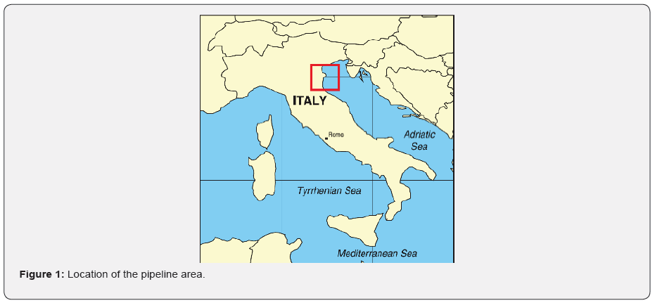
The Institute for Environmental Protection and Research (ISPRA), acting under the vigilance and policy guidance of the Italian Ministry of Ecological Transition elaborated and carried out the monitoring plan on the marine environment of an area affected by the realization of the first Italian offshore terminal for storing and regasifying liquefied natural gas and its pipeline, ubicated in the Northern Adriatic Sea (Figure 1). The aim of the environmental monitoring plan was to study the possible effects and the impacts on the marine environment of the antropogenic activities, through the application of an integrated approach (chemical, physical, ecological and ecotoxicological ones), involving all the potentially impactful environmental matrices: water column, sediments and biota [1,2]. In particular, with regard to impacts attributable to the offshore pipeline, the subtraction and temporary modification of soft-bottom macrozoobenthic community in the bottom strip along the pipeline route was taken into account [3,4].
The connection’s pipeline to the national distribution network consists of an off-shore section, approximately 15km long (from the offshore LNG regasification terminal to the coast), and an on-shore section, approximately 25km long [5-7]. The pipeline crosses progressive depths from 29m offshore to few meters near the coast, meeting seabeds with different geo-morphological characteristics. The pipeline, with a diameter of 30” [8,9] in the construction phase was layed on the bottom with simultaneous excavation of the trench and covered by the means of a specially equipped ship. The installation work lasted just few months in the period 2008-2009 but the monitoring activities covered a much longer period, approximately ten years from 2005 to 2015, to study the area of intervention before possible impact factors, during and after construction to verify the restoration of the seabed.
Materials and Methods
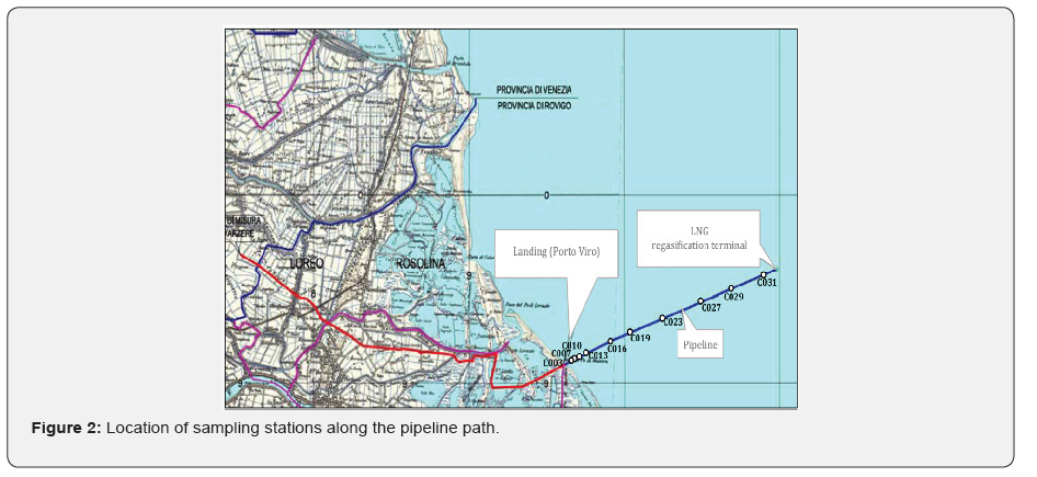
The monitoring strategy to investigate the benthic community structure was designed using a multi-step study approach to highlight any possible occurring variations. Sampling before the pipeline construction (ante-operam phase), sampling during the construction phase and the last after pipeline positioning (post-operam phase) were therefore performed. During the ante-operam phase, two sampling campaigns were carried out to assess the eventual seasonal variability (Winter 2005 and Summer 2006). During the construction phase (2008-2009), considering the short duration (March-April 2008) of the works, only one survey campaign was carried out; during the post-operam phase converserly annual campaigns were carried out, totally five, from 2010 to 2015, in order to verify any environmental alteration [10]. Therefore, during the monitoring activities, a total of 8 sampling campaigns were carried out. The sampling points were arranged considering the variability of the surrounding environments for a total of 10 stations each campaing, following a transept from the coast towards the open sea, located along the pipeline path (Table 1, Figure 2) [11,12].
Two sediment samples per station were collected by a Van Veen grab (0.1m2, 25L). The samples were then processed through a sieve (1mm mesh-size) and the retained fraction was fixed in 4% formaldehyde buffered with CaCO3, and finally stored in polyethylene containers. Next, in the laboratories, with the use of a microscope, all samples were grouped into principal taxonomic groups (Polychaeta, Mollusca, Crustacea and Echinodermata) and identified at the lowest possible taxonomic level (i.e., species).
The abundance data (replicas were combined) were processed with univariate and multivariate statistical techniques. Total macrofauna abundance (N), total species richness (S), Shannon index (H’) and equitability (J’) were calculated to explore possible quantitative and qualitative changes in assemblage structure among stations.
Multivariate data analyses were performed on square-root transformed abundance matrices. Similarity matrices were calculated using the Bray–Curtis similarity index [13], data were graphically represented using non-metric Multi-Dimensional Scaling (nMDS) ordinations and the Cluster analysis classification technique [14].
For each survey, decomposition of Bray–Curtis dissimilarity into relative contribution to dissimilarity from single species was calculated using SIMPER (similarity percentage) routines on untransformed abundance data matrices. Species were listed in decreasing order of their importance in the discriminating sets of samples [14].
TAB 1Considering the importance of the relation between macrobenthos community and sediments to understand possible alterations, also grain size analyses were carried out. The analytical activity for determining the granulometric characteristics of sediments provided three phases: preparation and pretreatment; separation of the sandy fraction from the pelitic one; analysis of the fractions obtained [15,16].
Results
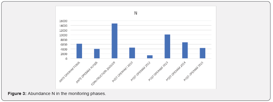
In the whole sampling area, over the entire sampling period, values of abundance for the whole macrofauna ranged from a minimum of 18 to a maximum of 5900 ind. The highest value of abundance N was found during the construction phase (2008-2009) in the station close to the coast (C003). During this phase the number of organisms was also up to three times higher than in other sampling periods (Figure 3).
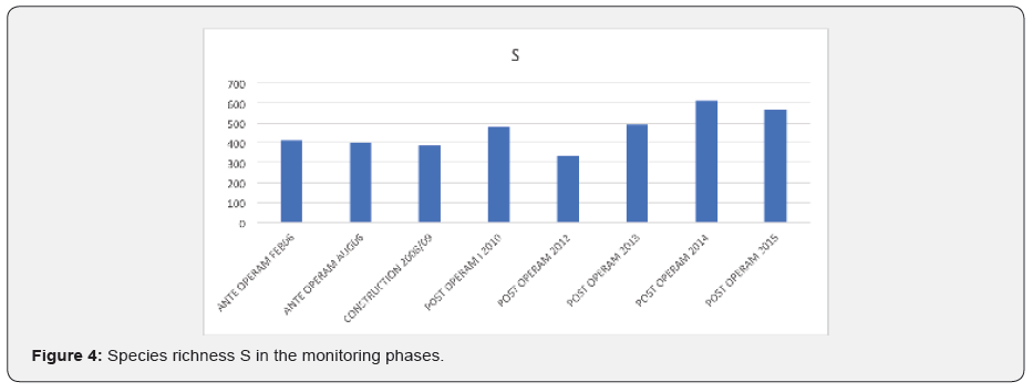
Across the entire sampling period (2010-2015), 707 different taxa of macrofauna were recognized. Species richness S ranged between a minimum of 336 (during the post operam 2012 phase) and a maximum of 612 taxa in the post operam 2014 phase (Figure 4).
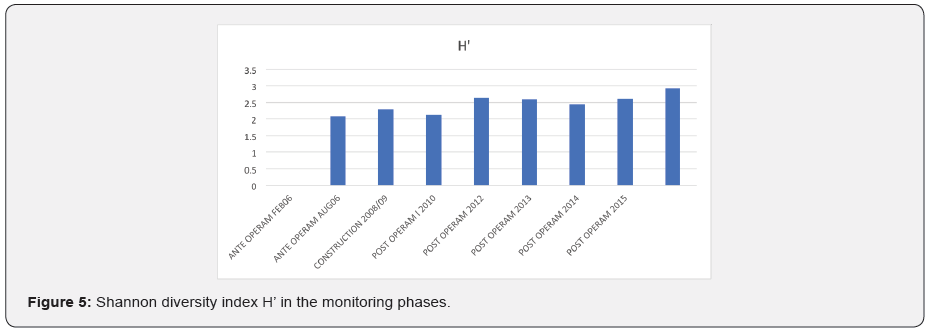
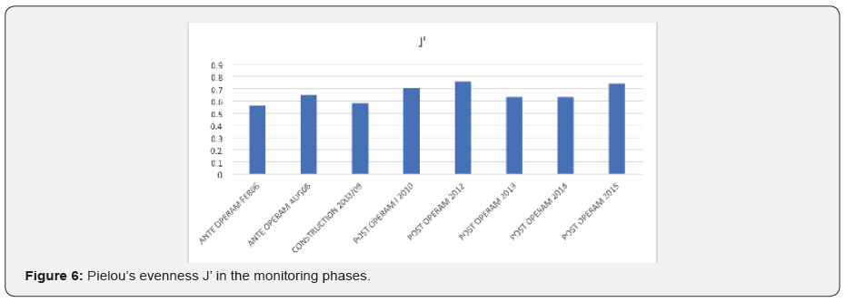
Shannon diversity index H’ showed comparable values across almost all sampling periods, from about 2 to about 3. During the last survey in the post operam phase (July 2015) we detected slightly higher values than the other surveys (Figure 5). In most of the sampling occasions, Pielou’s evenness J’ had lower values during the first ante-operam survey and during the construction phase. Highest values were detected during the 2012 and 2015 post-operam surveys (Figure 6).
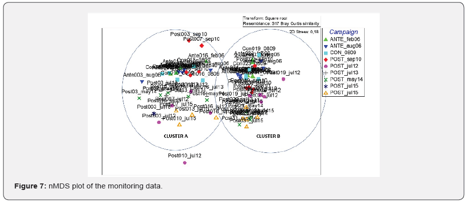
The global nMDS plot shows two dense clouds of stationpoints, the first one on the left side of the plot (Cluster A), including samples closer to the coast, while on the right side stations sited far away from the coast (Cluster B). Cluster A is characterized by stations laying on coarer sediment (sandy sediment), while Cluster B is composed mainly by stations with finest sediment (silty sediment).
It is not possible to appreciate a clear separation between the different campaigns. Samples belonging to the same survey appear more or less neighbors, to form singular campaign subclusters. More in detail, it can be observed that Reference points from same surveys are displaced relatively close together to each other, and likewise also points from the other surveys (costruction phase and in all the post operam surveys) all lie relatively close to each other (Figure 7). The macrobenthic community seems to be characterized by evident similarities in the different stages of monitoring considered.
SIMPER analysis for factor Campaign was performed using the average Bray–Curtis dissimilarity. E.g., between Ante_feb06 and Costruction_Aug09 surveys was 81.37, and this was made up mainly of 16.04% from Lentidium mediterraneum (O. G. Costa, 1830), and 10.32% from Prionospio caspersi (Laubier, 1962), both with higher abundances in the coastal sites.
The dissimilarity increased up to 89.77, between Ante_feb06 and Post_jul12 surveys, owing to the higher abundances of Prionospio caspersi (Laubier, 1962), Chamelea gallina (Linnaeus, 1758), Lentidium mediterraneum (O. G. Costa, 1830), Corbula gibba (Olivi, 1792), Owenia fusiformis (Delle Chiaje, 1844), in the Ante_feb06 campaign, which together with Cyclope neritea (Linnaeus, 1758), Amphiura filiformis (O. F. Muller, 1776), Mysella bidentata (Montagu, 1803) and Nucula nitidosa (Winckworth, 1930), accounted for 29.9% of the average dissimilarity between the two surveys.
Then, the dissimilarity arrived to 90.77 between Costruction_ Aug09 and Post_jul12 due to Lentidium mediterraneum (O. G. Costa, 1830), Chamelea gallina (Linnaeus, 1758), Prionospio caspersi (Laubier, 1962), Corbula gibba (Olivi, 1792), Owenia fusiformis (Delle Chiaje, 1844), Prionospio cirrifera (Wirren, 1883), Cyclope neritea (Linnaeus, 1758), and Donax semistriatus (Poli, 1795).
Discussion and Conclusion
The laying activities and the presence of a pipeline may interfere with the marine environmental quality, and it is necessary to elaborate and carry out an appropriate monitoring plan to assess the potential environmental impacts.
The monitoring activities of the pipeline were carried out considering all the environmental matrices using an ecosystem approach as recommended by the latest most innovative European legislations in the field of environmental protection [17,18].
The data acquired during the monitoring activities in the different phases (ante operam, construction and post operam) along the pipeline, outline a macrozoobenthic assemblage with typical ecological characteristics of a coastal-wide transept of the Northern Adriatic, in relation with the variation of the grain size of the sediments. Sandy sediment infact characterized coastal stations, while stations far away from the coast were mainly composed by silty fractions.
The macrozoobenthic communities studied in the post operam phase showed to have recovered to the best after the laying activities. They showed similar ecological characteristics among different sampling periods.
All structural parameters and the ecological composition of the macrozoobenthic assemblage indicated that the fifth year of the post operam phase values were comparable to those obtained during the ante operam phase, highlighting how the benthic assemblages of the marine-coastal area demonstrated high resilience capacity. They were able to counteract both natural stress and perturbations due to anthropic activities, surviving even in unfavorable conditions and almost completely recovering the initial ecological balance, considering also the short period for the pipeline installation.
References
- Virno Lamberti C, Gabellini M, Maggi C, Nonnis O, Manfra L, et al. (2013) An environmental monitoring plan for the construction and operation of a marine terminal for regasifying Liquefied Natural Gas (LNG) in the North Adriatic Sea C. In: Mediterranean Sea: Ecosystems, Economic Importance and Environmental Threats, Nova Science Publisher, Chapter 5: 115-133.
- ISPRA (2014) Elementi per l’aggiornamento delle Linee Guida del Progetto di Monitoraggio Ambientale (PMA) per le opere assoggettate a Valutazione di Impatto Ambientale (VIA), Acque Marine, p. 307
- Trabucco B, Grossi L, Marusso V, Bacci T, Bertasi F, et al. (2015) Macrozoobenthic assemblages around a marine terminal for re-gasifying liquefied natural gas (LNG) in the north Adriatic Sea (Italy). Journal of the Marine Biological Association of the United Kingdom 95(8): 1541-1553.
- Cicero AM, Di Mento R, Gabellini M, Maggi C, Trabucco B, et al. (2003) Monitoring of environmental impact resulting from offshore oil and gas installations in the Adriatic sea: preliminary evaluation. Annali di Chimica 93(7-8): 701-705.
- Edison Gas S.p.A. (1998) Terminale marino GNL da realizzarsi nel Nord Adriatico al largo del Delta del Po. Studio di Impatto Ambientale: Vol. 1, 2, 3.
- https://www.adriaticlng.it/it/il-terminale/perche-gnl/catena-del-gnl
- https://www.adriaticlng.it/it/il-terminale/la-struttura/il-metanodotto
- Ministry for the Environment and the Protection of Land and Sea (1999). Decree No. DEC/VIA/1999/ 4407.
- Ministry for the Environment and the Protection of Land and Sea (2004). Decree No. DEC/DSA/2004/866.
- ICRAM (2005a) Piano di Monitoraggio ambientale per il progetto di realizzazione ed esercizio del Terminale marino di rigassificazione LNG nel Nord Adriatico.
- Ellis JI, Fraser G, Russell J (2012) Discharged drilling waste from oil and gas platforms and its effects on benthic communities. Marine Ecology Progress Series 456: 285-302.
- Ellis JI, Schneider DC (1997) Evaluation of a gradient sampling design for environmental impact assessment. Environmental Monitoring and Assessment 48: 157-172.
- Bray JR, Curtis JT (1957) An ordination of the upland forest communities of Southern Wisconsin. Ecological Monographs 27(4): 325-349.
- Clarke KR, Gorley RN (2006) PRIMER v6: user manual/tutorial. Plymouth: PRIMER-E.
- Nota D.J.G. (1958) Sediments of the western Guyana shelf. Report of Orinoco shelf expedition, 2. Mendedel, Landbomvhogedrool, Wegeningen, 58, p. 98.
- Cicero AM, Di Girolamo I (2001) Metodologie analitiche di riferimento. Programma di monitoraggio per il controllo dell’ambiente marino costiero (triennio 2001-2003). Ministero dell’Ambiente e della Tutela del Territorio, ICRAM. P. 122.
- Directive 2000/60/EC of the European Parliament and the Council of 23 October 2000 A Framework for Community Action in the field of water in the Field of Water Policy EU: Bruxelles, Belgium, 2000.
- Directive 2008/56/EC of the European Parliament and of the Council of 17 June 2008 A Framework for Community Action in the field of marine environment policy in the Field of Water Policy EU: Bruxelles, Belgium, 2008.


