Evaluation of Erosion and Sedimentation Rates using the 137Cs Technique and the Contents of the Chemical Elements Fe, Ti, K, Mn, Zn, Ni and Cr in an Agricultural Field in Dakar, Senegal
Mamadou Lamine Sané1*, Modou Mbaye1, Alassane Traoré1, Moncef Benmansour2, Saliou Fall3, Djicknack Dione1, Mamoudou Sall4, Ababacar Sadikh Ndao1, Papa M N’diaye5 and Ahmadou Wagué1
1Department of Physics, Faculty of Sciences and Techniques, Institute of Applied Nuclear Technology, University of Cheikh Anta Diop, Senegal
2 Centre National de l’Energie des Sciences et des Techniques Nucléaires (CNESTEN), Morocco
3 Institut Sénégalais de Recherches Agricoles (ISRA)
4Department of Physics, Faculty of Sciences and Techniques, Laboratory of X-ray, University of Cheikh Anta Diop, Senegal
5 Department of Geology, University of Cheikh Anta Diop, Senegal
Submission: April 07, 2020; Published: April 20, 2020
*Corresponding author: Mamadou Lamine Sané, Institute of Applied Nuclear Technology, Department of Physics, University of Cheikh Anta Diop, Avenue Cheikh Anta Diop Po. Box 5005, Dakar, Senegal
How to cite this article: MamadouLamine S, Modou M, Alassane T, Moncef B, Saliou F, et al. Evaluation of Erosion and Sedimentation Rates using the 137Cs Technique and the Contents of the Chemical Elements Fe, Ti, K, Mn, Zn, Ni and Cr in an Agricultural Field in Dakar, Senegal. Int J Environ Sci Nat Res. 2020; 24(3): 556139. DOI: 10.19080/IJESNR.2020.24.556139
Abstract
Senegal is a sub-Saharan country which encounters degradation problems on its land. Of all the types of soil degradation, erosion is the one that contributes the most. However, in Senegal, the availability of erosion data, especially quantitative, is very limited. In this study, the aim is to use, for the first time in Senegal, the fallout of radionuclides to assess soil redistribution. Thus, the use of the anthropogenic radionuclide 137Cs has made it possible to estimate the rates of erosion and soil deposition relative to a period of approximately 60 years, at the level of an agricultural field in the Dakar region. An undisturbed field in the recent past was identified and served as a reference field in this study. The surface activity or the 137Cs inventory corresponding to this reference site is 414 ± 62Bq m-2. The transformation of 137Cs (Bq m-2) inventories into erosion or deposition rates was carried out using the “Mass Balance II” conversion model. The results obtained showed that the average and gross erosion rates were 18.8t ha-1 year-1 and 14.6t ha-1 year-1, respectively, while the average and gross deposition rates were 23.1t ha-1 year-1 and 5.2t ha-1 year-1, respectively. These results lead to a net erosion rate over the entire field of 9.4t ha-1 year-1 and to a rate of mobilized sediment leaving the study site of 65%. Analysis by X-ray fluorescence of the major chemical elements Fe, K and Ti in soil samples from the agricultural field produced average concentrations of 2.74, 0.16 and 0.74g kg-1, respectively. As for the minor chemical elements analyzed, the most preponderant is Cr followed in order by Ni, Mn and Zn.
Keywords: Erosion rate ; 137Cs ; radionuclides ; Eléments chimicals ; Sénégal
Introduction
Senegal is a country in the far west of the African continent. It is located between 12°30’ and 16°30’ north latitude and 11°30’ and 17°30’ west longitude [1]. In Senegal, there are two seasons: a dry season and a rainy season. The length of a season varies from region to region. The average temperature during the dry season is 25°C and the rainy season 31°C.
Senegal, like the other countries of the Sahel, is facing a problem of land degradation when it represents one of the most important factors of production. The earth is subject, among other types of degradation, to erosion. About 62% of Senegal’s degraded arable land is due to water erosion, or 1,510,000 hectares and 12% to wind erosion, or 287,000 hectares [2]. Arable land in Senegal represents only 19% of the territory, or 3.8 million hectares [3]. Besides the socio-economic impacts of reduced agricultural yields, erosion can cause ecological problems such as environmental pollution. Soil erosion is very little studied in Senegal, which justifies the limited availability of data on this phenomenon. In this paper a quantitative study of soil erosion is carried out using the anthropogenic radionuclide Cesium-137 (137Cs) but also a study of the behavior of the chemical elements Fe, Ti, K, Mn, Zn, Ni and Cr according to the topography of the site. 137Cs is an artificial radionuclide with a half-life of 30.17 years, produced during tests of thermonuclear weapons during the years between 1950 and 1970. After its production, 137Cs occupies the atmospheric layers. It reaches the ground by fallout processes in the wet (precipitation) or dry [4]. A correlation between precipitation and fallout from 137Cs has been established by [5,6]. On the surface of the soil, cesium 137 binds strongly and quickly to fine particles in the soil. 137Cs is almost non-exchangeable by chemical or biological processes in most environments. As a result of physical process, the soil is transported with the incorporated 137Cs. Therefore, to follow the movement of 137Cs is to follow the redistribution of the soil. The fallout of 137Cs on a locality is assumed to be spatially uniform and depends on the average annual precipitation and the latitude [7]. The evaluation of the redistribution is based on a comparison between the inventory of 137Cs measured on the study site and the inventory measured on the reference site. The latter must be a stable site over fifty years old and not subject to erosion or deposition. To obtain quantitative estimates of erosion or soil deposition rates from inventories of 137Cs it is necessary to use conversion models [8]. The 137Cs technique has many advantages compared to conventional monitoring techniques [9].
A quantitative study of soil erosion using radionuclide fallout has never been carried out in Senegal. Among the West African countries using this nuclear technique, Nigeria and Benin should be mentioned [10,11]. At the African level, Morocco and then Madagascar are considered to be among the first countries to carry out quantitative estimates of soil erosion and deposition on local sites. (Ex: [6,12-14]).
The objective of this work is to:
a) test the 137Cs technique in a sub-Saharan environment for the estimation of erosion and deposition rates in an agricultural field of the DAKAR peninsula,
b) contribute to the need for data on the state of soil degradation by erosion in Senegal,
c) provide information on the contents of the chemical elements Fe, Ti, K, Mn, Zn, Ni and Cr and follow their behavior in relation to the decrease in the slope
Materials and Method
Description of study and reference sites
The study site is located in Bargny, which is 20km from the Senegalese capital, Dakar, on the east side. The site’s GPS coordinates are 14°42’52.45’’N and 17°14’47.50’’W. The town of Bargny is in the region of Dakar, department of Rufisque and its geological coverage includes alternating marls and limestones. In addition, this eastern part of the Dakar region includes a set of hills and plateaus of altitudes below 50m [15]. The temperature of the area varies from 18°C and 39°C. The annual rainfall of the place is 511mm. August and September are the most rainy months. Bargny is in the Niayes area where vegetable crops such as tomatoes, onions, eggplants, salads are grown. Dakar and some regions of the center of the country are supplied with vegetables thanks to market gardening carried out in the Niayes area. The surface of the field of study is approximately 700m2 and located on a slope of approximately 16%. The study site is not far from a factory that has been located in Bargny since 1958. The reference site is in the environment of the agricultural field studied. The place does not suffer from visible erosion or deposition. The reference site seems to have remained undisturbed since the 1950s.
Sampling strategy
At the agricultural site of Bargny fourteen soil cores were taken from two transects, from the top to the base of the field, along the steep line and the runoff. A motorized corer for soil column was used for this sampling campaign. The distance between two consecutive sample collection points is 10m. Seven sampling points were taken from each transect. The depth of each carrot is 40cm for the purpose of sampling all of 137Cs [16].
At the reference site a total of 12 carrots were taken. One of the cores was cut to establish the vertical distribution profile of the 137Cs radionuclide. The soil core was cut in 4cm increments. The remaining 11 carrots will be used to provide the reference average surface activity value (inventory).
Analysis of samples by gamma spectrometry and X-ray fluorescence Gamma spectrometry
The samples were previously dried for 24h at a temperature of 80°C, crushed, sieved (<2mm) and homogenized. A representative part of each sample was taken and put in a cylindrical plastic container. The samples are analyzed by a gamma spectrometer fitted with a high purity germanium detector, Canberra model. The detector is coaxial type “P” characterized by a high energy resolution of 1.8Kev to 1332Kev with excellent peak symmetry and a relative efficiency of 30%. The detector calibration was carried out using a certified multi-gamma source and two reference materials (IAEA 327, IAEA 375). The samples are analyzed for a period of 86,000s. The activity calculation, using gamma spectra, using the GENIE-2000 software, made it possible to determine the content of the radionuclide 137Cs from its gamma energy line 661keV in each sample.
The “mass balance model MBM2” [8-17]
This model can be expressed as follows:

Where
A(t) is the 137Cs inventories (Bq m-2)
t is the time since the onset of 137Cs fallout (year)
R is the soil erosion rate (kg m-2 year-1)
d is the cumulative mass depth representing the average plough depth (kg m-2)
λ is the decay constant for 137Cs (year-1)
I(t) is the annual deposition flux at time t (Bq m-2 year-1)
Г is the proportion of the freshly deposited 137Cs removed by erosion before being mixed into the plough layer
P is the particule size factor
For 137Cs, the annual flux I (t) is expressed as:

Where:
In is a hypothetical record of annual 137Cs deposition flux for a site in the northern hemisphere based on the record of 137Cs deposited to the northern hemisphere (Bq m-2 year-1)
An (Bq m-2) is the current inventory for the hypothetical 137Cs fallout record
Aref (Bq m-2) is the 137Cs reference inventory for the study site.
Г is expressed as pγ (1 e R H ) − Γ = − where γ is the proportion of the annual 137Cs input susceptible to removal by erosion and H (kg m-2) is the relaxation mass depth of the initial distribution of fallout 137Cs in the soil profile.
XRF analysis
The samples from the study site were also analyzed by a portable X-ray fluorescence device. XRF was performed with 100% normalization and full fundamental parameter quantification techniques. The metal content of sodium was determined by ICP-AES to be 0.4, 0.470, 5.14 and 4.12% in ultrabasite (UB), granodiorite-mylonite (D155), granodiorite (D153), and granite (D141A), respectively.


Results and Discussion
Reference site
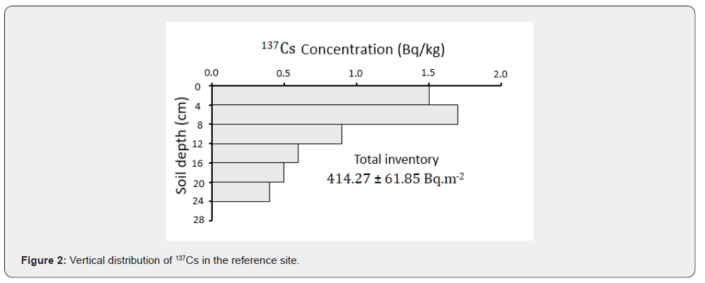
The vertical distribution profile of the 137Cs concentration in the depth follows an exponential decay (see Figure 2). This form of exponential decay has been established in several studies [18,19]. Most of the 137Cs was concentrated in the upper part from the surface of the profile. About 84% of 137Cs was in the first 16 centimeters. This is in line with the study by Mabit et al. [19] which indicated that a large proportion of 137Cs was located in the upper 15cm of the soil. The greatest concentration value of 137Cs, 1.7Bq kg-1, was located between the fourth and the eighth centimeter of the profile. Below the 24cm depth the 137Cs had not been detected. Its value is lower than the detection limit of 0.4Bq kg-1. The coefficient of variation is within the acceptable range of values according to the study by [20]. The reference inventory is 414.27Bq m-2, the standard deviation is 61.85Bq m-2 corresponding to a coefficient of variation of 16%. In this study, the measured reference value is lower than that estimated by the “Mass Balance II” conversion model [17] which is 575.84Bq m-2.
The reference inventory of this study is lower than other reference inventories of the regions of the African continent located in the northern hemisphere [10,13] but close to Benin reference inventories [11]. This similarity is due, on the one hand, to the geographical position of the Dakar region where the study is carried out. Dakar is a peninsula (except in the east where the Thiès region is located, Dakar is surrounded by the Atlantic Ocean) with an area of 550km2 located in the far west of Senegal. Cesium 137 is deposited both dry and wet. The movement of the air mass is generally from west to east. On the other hand, the rainfall in the Dakar region, of around 500mm per year, is much lower than that of Benin.
Study site
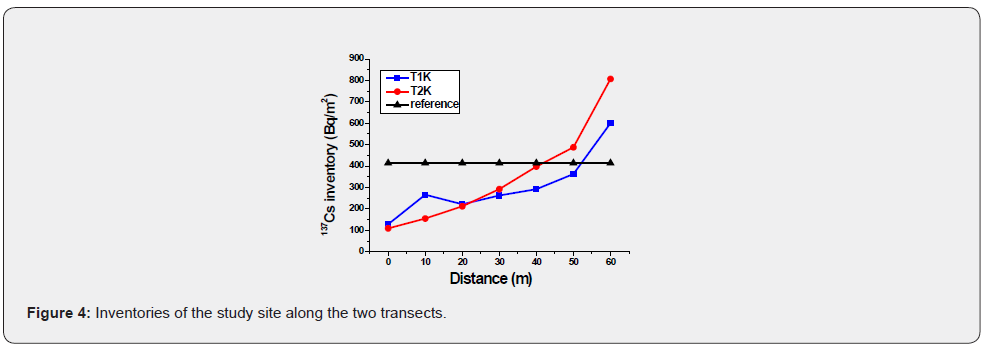
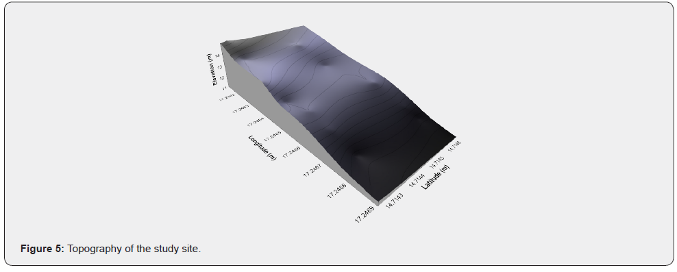
The vertical distribution of 137Cs in the soil of the cultivated field showed that the radioelement is present up to a depth of 24cm. This is due to the use of an agricultural machine resulting in an almost homogeneous distribution of the radionuclide 137Cs in the depth profile due to the frequent mixing of agricultural soil (Figure 3). The cesium 137 is inventoried at the cultivated site on two parallel transects. 7 soil samples were taken for each transect. Out of the 14 points sampled, 3 have inventories greater than the reference value 414.27Bq m-2. There is then a deposition on these three sampling points. On the 11 remaining points there is a loss of soil. On transect 1, the 137Cs inventory varies from 128.5 to 600.5Bq m-2 while at transect 2 it varies from 109.0 to 807.0Bq m-2 (Figure 4). Li et al. [21] and Estrany et al. [22] showed in their study the decrease in the inventory of 137Cs with the increase in the slope. In this study the reduction in the inventory of 137Cs along the slope varies from 69% and 74% at the top of the slope for transect 1 and 2, respectively. At the bottom of the slope, the gains in 137Cs are 45% and 95% for transect 1 and 2, respectively. Furthermore, the variation of 137Cs activity along the slope also seems to depend on the topography and the local change in the slope from the summit to the base of the field (Figure 5). The lowest transect 2 sampling point appears to have lateral inputs of the radionuclide 137Cs. The origin of the significant loss of 137Cs is certainly due to the cultivation practice, runoff and the absence of soil conservation practice but it should also be noted that the tillage is parallel to the direction of runoff, and does not favor therefore not the stability of the soil in the field.

Erosion rate
Inventories calculated from mass activities are converted into erosion and deposition rates. This conversion is carried out using the conversion model: “Mass Balance model 2 MBM2”. Some of the parameters used in the MBM2 model were determined according to local basic conditions while the others were taken by default.
a) The plough depth of the cultivated site is 25cm. Plowing is carried out mechanically by an agricultural machine.
b) The proportion factor γ is the ratio of the amount of rainfall during the winter season to the annual rainfall amount and is equal to 0.8.
c) The relaxation mass depth in the initial distribution of cesium 137 in the soil profile (H) was taken by default according to Walling et al. (2011), H = 4kg m-2.
d) The plough depth of the cultivated site was determined d = 386.5kg m-2
e) The particle size factor taken is P = P ’= 1
f) The reference activity which was used Aref 414.27Bq m-2.
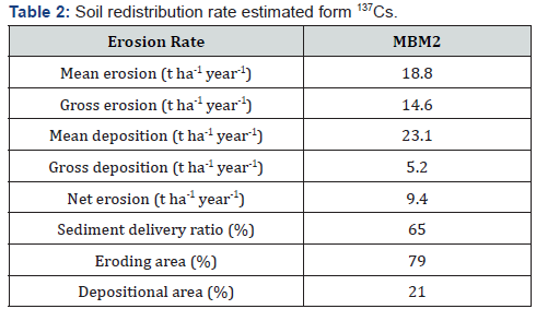
The erosion rate assessed at the study site level varies between 1.3 to 43.0t ha-1 year-1. This erosion covers 79% of the surface of the agricultural site. There is more erosion at the top of the slope. It decreases at the same time as the slope attenuation. The 21% of the surface of the agricultural field undergoes a deposition which varies from 8.54 to 45.68t ha-1 year-1. The mean and gross erosion were 18.8t ha-1 yr-1 and 14.6t ha-1 year-1, respectively. As for the average and gross deposition, they were estimated at 23.1t ha-1 year-1 and 5.2t ha-1 year-1, respectively. The amount of sediment that left the study site is approximately 65% (Table 2). Water runoff greatly contributes to the movement of soil down the slope. The climatic conditions typical of the sub-Saharan environment are also favorable to erosion. The agricultural field is very intensely cultivated. The culture being applied along the slope.
Concentrations of the chemical elements analyzed
Analysis of soil samples from the Bargny agricultural field by X-ray fluorescence made it possible to determine the concentrations of the chemical elements Fe, Ti, K, Mn, Zn, Ni and Cr. The average concentrations of the major elements show the classification according to Fe>K>Ti while that of the minor elements, it should be noted that their average concentrations follow the following decreasing order Cr>Ni>Mn>Zn (Table 3). The global average concentrations of the elements Ti, Cr, Ni, Mn and Zn are 7038, 59.5, 29, 488 and 70mg kg-1 respectively [23]. They are higher than the concentrations found in this study. Despite the use of chemical fertilizer, fertilizer, pesticides and industrial anthropogenic inputs, the concentrations of the chemical elements studied remain relatively low. Sané et al. [24] carried out a similar study accompanied by an assessment of radio-toxicological risks in the area.

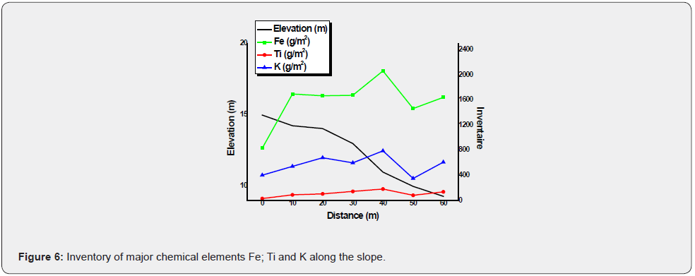
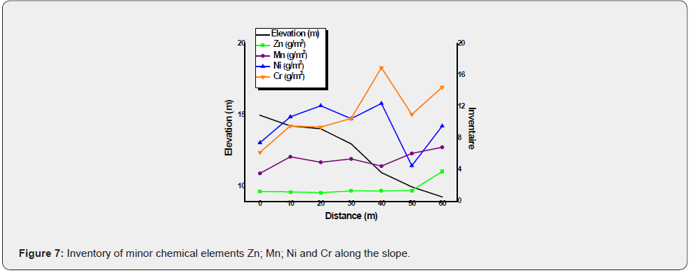
The inventories of the chemical elements Fe, Ti, K, Mn, Zn, Ni and Cr measured on each sampling point of the transect 2 of the disturbed site made it possible to draw the curves of Figure 6 & 7. The inventories of the chemical elements varied all along the transect. Each element followed the movement of the soil in its own way. Cr, Ni and Fe, in the agricultural soil of Bargny, seem to have quite similar attitudes on the transect. Whereas K and Mn were the two elements which seemed to follow more the behavior of 137Cs on this transect than the other chemical elements. The Ti and Zn elements were almost constant over the first 40 meters from the top of the slope despite the effect of soil erosion.
The difference in behavior of the chemical elements may be due to the nature of the soil, to cultural practices, but also to the migration capacity of the mineral and organic retention components of the elements studied. At the bottom of the slope the inventories of Ti and Zn were higher, 140.17g m-2 and 3.76g m-2, respectively. Fe had the highest inventory in terms of major elements while for minor elements it was Ni and Cr.
The texture of the soil at the study site was predominated by sand at 63%, the silt represents 17% while the clay is 19%. The amount of organic matter was on average 76% and the average pH 6.9.
Conclusion
The nuclear technique of quantitative soil erosion assessment is used for the first time by this study in Senegal in an agricultural field located on a slope. This technique has many advantages over conventional methods. The inventories found in the study site are, in general, about the magnitude of other results from West African countries like Benin and Nigeria. The “mass balance model 2 MBM 2” model was used to convert inventories into erosion and deposition rates. MBM 2 takes into account many factors that can influence the redistribution of soil. A net erosion 9.4t ha-1 year-1 was found for the agricultural field studied.
After this successful test, the FRN technique can be implemented in other localities of the country such as the groundnut basin which are suffering from the degradation of arable land by erosion. It can also be used to meet the needs of erosion data in certain localities of the country.
Concerning the chemical elements, the measurements have shown that the concentrations are relatively low and that each element has its own behavior on the soil surface. These data can be used in the event of future studies of evolutionary monitoring on the annual flow of metals on this agricultural soil.
Acknowledgement
This study is carried out within the framework of the regional African technical projects RAF 5063 and RAF 5075 funded by the IAEA. The objective of these projects is to support innovative conservation farming practices to combat soil degradation and increase soil productivity for improved food security.
References
- (Centre de Suivi Ecologique) (2003) L'evaluation de la degradation des terres au Sénégal (Rapport Préliminaire), p. 62.
- CSE (Centre de Suivi Ecologique) (2000) Annuaire sur l'environnement et les ressources naturelles au Sénégal (Première édition). Ministère de l'Environnement et de l'Assainissement de la République du Sénégal, p. 216.
- Berger L, et al. (1996) In plan d'Action Foncier/Plan Céréalier, DEL.
- Ritchie C, McHenry R (1990) Application of radioactive fallout cesium-137 for measuring erosion and sedimen accumulation rates and patterns. a review. Journal of Environmental Quality 19: 215-233.
- Owens NP, Walling DE, He Q, Shanahan J (1997) The use of cesium-137 measurements to establish a sediment budget for the Start catchment, Devon, UK. Hydrological Sciences Journal 42: 405-423.
- Benmansour M, Mabit L, Nouira A, Moussadek R, Bouksirate H, et al. (2013) Assessment of soil erosion and deposition rates in a Moroccan agricultural field using fallout 137Cs and 210Pbex. J Environ Radioact 115: 97-106.
- Walling DE, Quine TA (1995) The use of fallout radionuclide in soil erosion investigations. Nuclear Techniques in Soil-Plant Studies for Sustainable Agriculture and Environmental Preservation. IAEA Publ: International Atomic Energy Agency Publication, pp. 597-619 (ST1/PUB/947).
- Walling DE, He Q, Appleby PG (2002) Conversion models for use in soil erosion, soil-redistribution and sedimentation investigations. In: Zapata F (Ed.), Handbook for Assessment of Soil Erosion and Sedimentation using Environmental Radionuclides. Kluwer, Dordrecht, The Netherlands, pp. 111-164.
- IAEA (International Atomic Energy Agency) (2014) Guidelines for Using Fallout Radionuclides to Assess Erosion and Effectiveness of Soil Conservation Strategies.
- Junge B, Mabit L, Dercon G, Walling D E, Abaidoo R, et al. (2010) First use of the 137Cs technique in Nigeria for estimating medium-term soil redistribution rates on cultivated farmland. Soil Til Res 110(2): 211-220.
- Kouelo AF, Houngnandan P, Azontondé HA, Benmansour M, Rabesiranana N, et al. (2015) Assessment of the level of soil degradation three watersheds affected by intensive farming practices in Benin. Journal of Experimental Biology and Agricultural Sciences 3(6): 529-540.
- Benmansour M, Ibn Majah M, Marah H, Marfak T, Walling DE (2000) Use of the137Cs technique in soil erosion in Morocco - Case study of the Zitouna basin in the north. Proceeding of an international Symposium on Nuclear Techniques in Integrated Plant Nutrients. Water and Soil management, IAEA/FAO 33(32): 308-315.
- Nouira A, Sayouty EH, Benmansour M (2003) Use of 137Cs technique for soil erosion study in the agricultural region of Casablanca in Morocco. J Environ Radioact 68(1): 11-26.
- Rabesiranana N, Rasolonirina M, Solonjara AF, Ravoson HN, Andriambololoa R, et al. (2016) Assessment of soil redistribution rates by 137 Cs and 210 Pb ex in a typical Malagasy agricultural field. J Environ Radioact 152: 112-118.
- ANSD (Agence National de la Statistique et de la Démographie) (2012) Situation Economique et Socilae regionale.
- Estrany J (2009) Hydrology and sediment transport in the agricultural Na Borges River basin (Mallorca, Balearic Islands). A mediterranean groundwater-dominated river under traditional soil conservation practices. Unpublished PhD thesis. University of the Balearic Islands, Palma.
- Walling ED, He Q, Zhang Y (2014) Conversion models and related software. In: Guidelines for Using Fallout Radionuclides To Assess Erosion and Effectiveness of Soil Conservation Strategies. IAEA-TECDOC-1741. IAEA Publication, Vienna, Austria, pp. 125-148.
- He Q, Walling DE (1997) The distribution of fallout 137Cs and210Pb in undisturbed and cultivated solis. Applied Radiation and Isotopes 48(5): 677-690.
- Mabit L, Benmansour M, Walling DE (2008) Comparative advantages and limitations of fallout radionuclides (137Cs, 210Pb and 7Be) to assess soil erosion and sedimentation. Journal of Environmental Radioactivity 99(12): 1799-1807.
- Sutherland RA (1996) Caesium-137 soil sampling and inventory variability in reference locations: a literature review. Hydrological Proceedings 10(1): 43-53.
- Li M, Yao W, Li Z, Liu P, Shen Z (2010) Effects of landforms on the erosion rate in a small watershed by the 137Cs tracing method. Journal of Environmental Radioactivity 101(5): 380-384.
- Estrany J, Garcia C, Walling DE (2010) An investigation of soil erosion an redistribution in a Mediterranean lowland agricultural catchment using Caesium-137. International Journal of Sediment Research 25(1): 1-16.
- Kabata-Pendias A (2011) Trace elements in soils and plants. (4thedn), Taylor and Francis.
- Sané ML, Mbaye M, Traoré A, Dione D, Sall M, et al. (2019) Assessment of natural occurring radionuclides (40K, 226Ra, 232Th) and heavy metals in a disturbed and undisturbed soil in the region of Dakar, Senegal. Int J of Adv Res 7(9): 1341-1351.


