Initiations for Sustainable Land (Soil) Resource Management at Municipal Level: A Case from Sitganga Municipality, Nepal
Kabi Prasad Pokhrel*
Research Centre for Educational Innovation and Development-CERID, Tribhuvan University, Nepal
Submission: May 15, 2018; Published: May 25, 2018
*Corresponding author: Kabi Prasad Pokhrel, Pokhrel KP, Professor, Research Centre for Educational Innovation and Development-CERID, Tribhuvan University, Panika Road, Kathmandu 44618, Nepal, Tel: +91 98493 01741; Email: drkabipokhrel@gmail.com
How to cite this article: Kabi P P. Initiations for Sustainable Land (Soil) Resource Management at Municipal Level: A Case from Sitganga Municipality, Nepal. Int J Environ Sci Nat Res. 2018; 11(4): 555816. DOI: 10.19080/IJESNR.2018.11.555816.
Abstract
The paper is an attempt to analyze the land resource management practices at the municipal level to map out the current land use pattern with potential land use zoning with a view to categorize and assess land based on the optimal suitability for sustainable management of land resources using multi criteria analysis method with strong support from GIS, GPS and RS analysis techniques. Land (soil) resource management includes three interrelated levels: national, province and municipal with the purpose of land policy implementation, legislation and regulations in force, effective implementation of measures to protect soil cover, to maintain ecological balance and biological diversity in ecosystems of the Chure region. The soil cover quality on the most agricultural land is unfavorable, and on some land areas are critical in the sense of soil fertility to support intensive agricultural farming. Continue to expand the area affected by erosion and landslides, land degradation processes, damage of structure and low level of organic matter and soil acidity drought intensified. Land management in the Chure region requires a process of development and implementation system of organizational, economic and administrative levers. They would allow regulation and development the forecast of quality land status; develop outline for the rational use of land, combating soil degradation processes and long-term preservation of agricultural production capacity. Basic information for proper management of land resources must become computerized information system of the state of soil quality.
Keywords: Land Resource; Soil Characteristics; Land Degradation; Land Capability; Land Use Zoning; Risk Assessment
Introduction
Land resources, including soils, are basic resources of agricultural production for food and markets. Their proper management is fundamental to enhancing the capacity and output of the sector, especially to meet macroeconomic priorities of livelihood improvements and economic growth. The soil resources in the Chure are unmetered and not renewable, possessing relatively low fertility, taking into consideration the region’s geo-physical conditions with fragile ecology. Current farming practices (crops and livestock) have not been helpful to prevent the depletion of the already limited fertility of the soil resources, especially their continuous use without soil cover, poor soil fertility management, and injudicious method of cultivation SADC/SACCAR [1]. Land allows for a variety of uses and can satisfy a diverse range of objectives. Land use is a basic element in human activity. Much of what we humans do requires land. The concept of land use refers to a series of activities done to generate one or more products or services. The same land use can occur on several different parcels of land, and reciprocally, the same land may have several uses. An activity-based definition of land use allows for a detailed quantitative analysis of both economic and environmental impacts, as well as enabling different land uses to be clearly distinguished FAO [2]. If land resources are to support continuing human activities in a sustainable way, then other functions of the land need to be kept in balance. Land is highly sought for various human activities. Such activities (current or future) depend, to a greater or lesser degree, on the surface of the earth, its minerals, its water and its other renewable and non-renewable resources. Generally, the same parcel of land cannot be used for more than one object simultaneously this generates competition between different land-use activities for a piece of land.
Pressing issues such as water and food security, health, peace, and poverty are deeply linked to land degradation. Nepal’s major land restoration programs as a case offering perspective on the existing problems in Nepal’s major policies for improving degraded land and maintaining land resources in three dimensions. The shortcomings and outcomes in terms of biophysical consequences, socioeconomic benefits, and political goals are to be addressed, namely
(i) Non-integrated land resources management creates new problems while solving existing problems.
(ii) Non-participatory processes and one-size-fits-all measures compromise socioeconomic benefits.
(iii) Implementation outcomes conflict with policy targets for sustainable land management and development Schwärzel [3].
Based on Chinese experiences for more sustainable land management, developing countries like Nepal needs to create a new mode of economy and environment in plans and actions of restoring degraded land resources, and establishing multifunctional land-use systems based on formulating and balancing multiple benefits/services across socio-ecological sectors Zhang et al. [4]. Soil is a natural body with an organomineral complex composition and properties that provides the necessary conditions of plant growth. Thus said, soil holds fertility - the ability to produce agricultural production. As support and living environment for humans, plants and soil animals is an inestimable wealth of all people, irrespective of ownership, must be used according to the interests of national economic development, in accordance with applicable law. Proper management of soil fertility resources is a primary social problem for Republic of Moldova. Soil resources and use them in agriculture have their ecological and economical aspects. Republic of Moldova is characterized by very complex city of soil cover. The soil variability and zonality of the territory are caused by climate change, topography and vegetation, from North to South of Moldova. Depending on climate and soilzonality in Moldova are highlighted three agro-pedo-climatic areas: North, Centre and South, which is divided into subareas.
Predicting the response of soils to climate change is extremely important as the top meter of soils globally contains 3 times as much carbon as the atmosphere Saskia et al. [5]. Small changes in soil carbon stocks can therefore have important impacts on climate if soil carbon is lost, it could provide a positive feedback to climate warming). On the other hand, if soils can be managed to store more carbon, they can help to reduce the amount of carbon in the atmosphere, and thereby mitigate climate change. Climate change has complex impacts on soils. Increasing temperatures will tend to increase decomposition, but this will be limited where soils become very dry so changes in temperature and precipitation can have additive effects, or may work in opposite directions. In addition, increasing temperatures can also increase plant production, thereby increasing carbon inputs to the soil. This may also decrease the direct impact of climate change on soils and may increase soil carbon Smith [6]. Changes in precipitation patterns and amounts l also influence soil organic carbon stocks through their effect on dissolved organic matter production and mobility. This not only affects the soil carbon stock itself but also couples it to the carbon cycle in aquatic systems Jansen [7]. While climate change clearly affects soil organic carbon stocks, the magnitude of the effect depends on the intricate interplay of local external factors, such as climate, and the ecosystem-specific composition of the organic matter itself that steers its interactions with the inorganic soil phase. As a result, not only soil organic carbon stocks but also their predicted response to climate change varies between ecosystems. Nevertheless, while modeling studies confirm there is considerable regional variation, with some regions gaining in carbon and some regions losing carbon, climate change is projected to increase soil carbon stocks on mineral soils (i.e. non-peaty soils). On the other hand, peat lands, which contain enormous stocks of carbon (similar to the quantity of all carbon in the atmosphere), may be more susceptible to climate change. When these soils heat up, or if they become drier, vast quantities of carbon could be lost Joosten [8].
Land Management Investment Framework 20160-2020. Only about 57 % of the total arable land being put under cultivation is mainly attributed to the reason that the traditional farming population is ageing and can no longer effectively continue farming. The active young populations are not interested in farming but in white-collar jobs around the urban areas or in travelling to the west in search of so-called greener pastures. The government has to put strategies in place to reverse this trend with giving emphasis on more productivity in per unit area of land by adopting entrepreneurship development initiative (NEDI) and the national youth service scheme (NYSS) NPC [9]. Planning and executing sound natural resource management at watershed and landscape levels has become increasingly important for retaining ecological integrity and ensuring that food and fiber systems are resilient enough to absorb shocks, stresses and avoid land and water resources degradation. Prioritizing and addressing desertification, land degradation and climate change challenges in Himalaya is critical for achieving food security and nutrition, their adaptation to climate change, protection of biodiversity, development of resilience of soil to natural disasters to benefit from new scientific knowledge detailing extent and importance of ecosystem services and their roles in sustaining human and agro-ecosystems. Sustainable land management which combines technologies, policies and activities aimed at integrating socioeconomic principles with environmental concerns is to be advocated for agricultural and livelihood purposes.
Regarding the issue of land management, prioritizing sustainable soil management in geologically fragile Chure region in Nepal is essential where land/soil degradation seen as a common sight that continues decades. Due to the absence of the mandate institution at the municipal level to oversee use, sustainable management of natural resource (soil) and monitoring incidence regularly. Besides this, productive agricultural lands are rapidly impoverished due to nutrient mining by crops, soil erosion and improper soil management practices. Integrated soil health/quality management practices are required and new approaches need to be adopted to ensure sustainable agricultural productivity, food security and environmental conservation WRB [10]. National Land Use Policy [11] has mandated eleven land use categories and five levels agricultural land use classes. The major sub-sectors of agriculture are
a) Cereal crops
b) Cash crops
c) Fruit farming
d) Livestock and poultry
e) Fisheries
f) Agro-forestry
Agriculture is predominantly subsistence, using very little mechanization and inputs, and rain-fed, with very little irrigation. As such, the agricultural productivity is low, and the sector is especially vulnerable to droughts. The need for sustained efforts at addressing the degradation problem through promoting and improvement of sustainable soil/land management activities in the region therefore, is important. However, it is recognized that the cost of implementing SLM activities over a large area is huge and cannot be easily borne by single institution. Yet, without such interventions, the expected achievements of enhanced livelihoods of many of the smallholder farmers as well as both human and environmental health would be adversely affected. Recognizing the challenges faced by the natural resources including agriculture, National Land Use Project has undertaken to map out the current land use pattern with potential land use zoning with a view to categorize and assess land based on the optimal suitability for sustainable management of land resources.
Method and Approach
Both primary and secondary sources of data were used for the present study. The primary information of was collected using multi criteria analysis method with strong support from GIS, GPS and RS analysis techniques. The secondary information was collected through review of related documents. To carry out the study, two approaches were used for land resource data generation, mapping and reporting using satellite remote sensing data which is available in both format as digital (softcopy) and imageries (hard copy).
a) Computer Aided Digital Analysis Approach: Digital analysis of remote sensing data utilizing the computers has been developed to meet the requirement of faster analysis and extract information from the large quantities of data based on the utilization of the spectral variations for classification.
b) Visual Image Interpretation: Visual interpretation is based on shape, size, tone, shadow, texture, pattern, site and association. This has identified number of elements such as land type, drainage pattern and drainage condition, vegetation, land use, slope and relief.
The landform and associated soil properties of the project area were identified through conducting preliminary reconnaissance survey during the pre-field visits. The preliminary survey information used for recognition of soil mapping units and selecting the appropriate soil pits to study the morphological characteristics and soil sample collection for the physical and chemical determination in various landform/units. Physiography, landform and their associated soil properties were studied during the field work which was conducted the selected soil pits. For this, landform, geology, climate and vegetation and their relationship with morphological properties of the land resources (soil) were identified using aerial photo and satellite imagery. The points for study were fixed and observed the morphological characteristics such as texture, color, horizons, soil depth, moisture status, structure etc. of the soil at that point through intensive field study. Altogether 136 soil samples were collected from profiles with digging standard size and has analyzed in the soil laboratory. Information of site characteristics, soil characteristics and horizon characteristics of each soil pit at different horizon level were converted into digital tabular format in order to join with the spatial location of soil pits. All spatial locations of each soil pit were transferred into the same scale of geo-referenced base map projected on MUTM parameters.
It is assumed that the soil sampled from the selected pits covered all units of delineated landform which was demarcated by using land system map, land use map, topographical map and World-view Satellite imagery provided by NLUP. Soil profile was observed by applying geo-statistical sampling method, systematic sampling of accurate interpolation by trigging producing spatial pattern for accurate estimation of semi-variogram. A regular grid with square, triangular or hexagonal elements used and placement of sample locations is in the center of each grid cell. The soil profile of pit was described following the Soil Survey Manual of United States Department of Agriculture (USDA) and FAO guidelines 1998. The soil properties were observed based on the form of soil survey provided by NLUP. The soil sampling was done from each horizon for the chemical and physical analysis of soil to know the fertility status of soil. Besides the topographical map, standard false color composite (FCC), land system maps were used for the basic information of the study. Based on the differences in physiography, parent material, drainage class and profile development of the soil groups were defined into soil map units.
Geophysical Setting of The Study Area
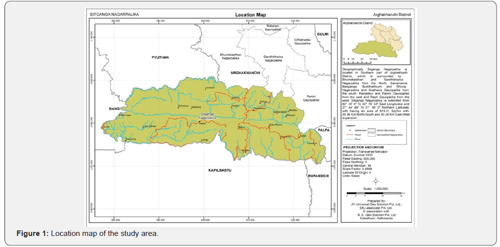
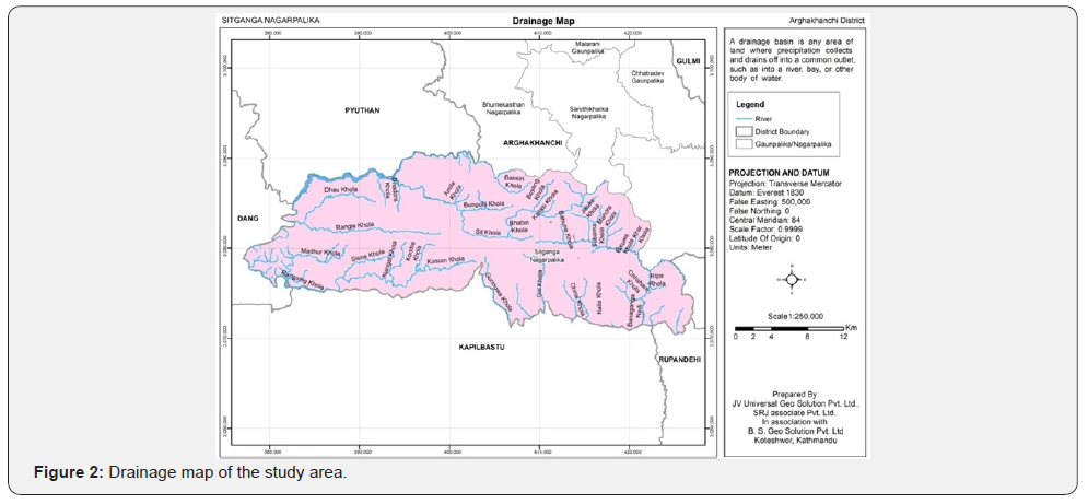
The study was conducted in Sitganga Municipality extended 82˚45’4’’ east to 83˚15’34’’ eastern longitudes and 27˚44’48” north to 22˚56’2” northern latitudes with having an area of 610.66 spkm with 20.34 km north-south length and 50.24 km east-west width. Altitude ranges from 157 masl to 2375 masl. Geologically, the municipal area crosses the Main Frontal Thrust (MFT) which distinguishes the physiographic features of Mahabharata and Chure region. The topographical features of the municipality vary from river basin, tar low land with gentle slope to hills, ridge, middle hills, and hilltop, and hilly region with steep slope. The relief features of the municipality appear in complex form from lowland with gentle slope to hills and hillocks with steep slope. Due to the relief feature variations number of micro topographic features are apparent in the terms of shaded relief, slope gradient, and digital elevation (Figure 1). The municipal area is composed of quaternary river valley deposits. The river banks have a mixed bed of river gravel and boulder beds cemented loosely by sand; clay and silt clay underlie the upper beds of yellow to dark grey clay and silt clay. Boulder and gravel beds are of 1-2 m to 8-10 m thick. Compositions of boulders are mostly quartzite, schist and gneisses. The Slope of the land form of the Nagarpalika varies from 3 degree in low or river basin to above 25 degree in high land. Gundrung, Banganga, Dhir Bhangala(Gai Khola), Sukbel Khola, Chor Khola, Khormor Khola, Sit Khola, Khayar-Bhatti, Kondre Khola, Lungridhawa Khola, Siling Khola, Ransing Khola, Surahi Khola, and West Rapti are the major river/streams, of the Nagarpalika which originate from Mahabharata and Chure region. The drainage pattern of the Nagarpalika is north to south and all river/streams drain towards the west and south direction (Figure 2).
The municipal area falls in lower tropical climate with temperatures reaching 25 above Celsius in May-June and falling to single digits in winter. The maximum temperature is recorded in the months of May and, June above 25 degree Celsius and the minimum temperature in the month of December January less than 10degree Celsius. There is a fluctuation in maximum and minimum temperature since 2007 to 2016. However, the yearly temperature found to be increased. The average annual rain fall of the Nagarpalika also varied annually since the decade. The highest amount of monthly rainfall records in June 5549.40 Milliliter and lowest rainfall amount in November 8.9 Millimeter.
Land Degradation
Soil erosion and landslides and increasing human encroachment (settlements, roads and shifting cultivation) are core issues in the region. In addition, forest fire (particularly at the lower belt of Chure region and in the government forest area, over grazing and timber smuggling; and extraction of river bed deposits (especially from the small rivers and streams of the Chure region) are other burning issues of the land resource management in the municipal area which is known as the Chure region from the geophysical perspectives. Over the last three decades, there has been a tremendous change in land use and land cover in this area. Conservation of forest to cultivation has been the main pathway of land use and land cover change in the region. A study carried out by Pokhrel [12] shows that the agricultural land is increased by 85 percent from 1954 to 1990 whereas the forestland is decreased by 13.25 percent in the Banganga river basin area. This massive alteration in cultivated land and forest coverage reflects into adverse impacts on the hydrological and environmental processes in the basin [13].
Land System and Soil Characteristics
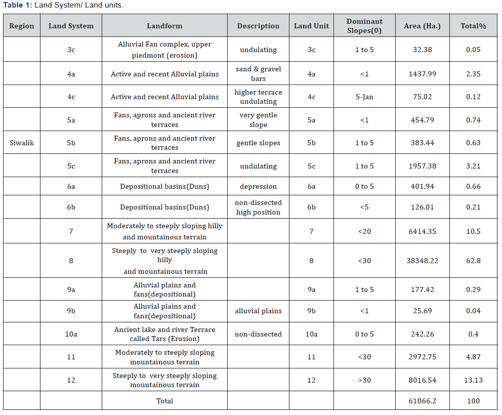
The land units defined by LRMP are further subdivided based on local field variation associated with the different land use practices. Based on geological structure and topographical features different types of land system and seven land units have been identified in the study area associated with the local microrelief variations. The spatial coverage of each land units has been presented (Table 1) reveals three land system and seven land units are in the municipal area where 62.80 percent land is under steeply to very steeply sloping hilly and mountainous terrain, 13.13 percent steeply to very steeply sloping mountainous terrain, 10.50 percent moderately to steeply hilly and mountainous terrain, 4.87 percent moderately to steeply sloping mountainous terrain, and 2.35 percent active and recent alluvial plains. The soils of the study area are classified based on the morphological, chemical and physical properties of soil acquired from the soil profile study by digging 136 soil pits and soil mapping unit level. USDA soil taxonomy system of soil classification was adopted for the classification of soil in which soils are classified into order, sub-order, great group, sub-group, and family and series levels. The soil classification of the study area is presented in (Table 2).

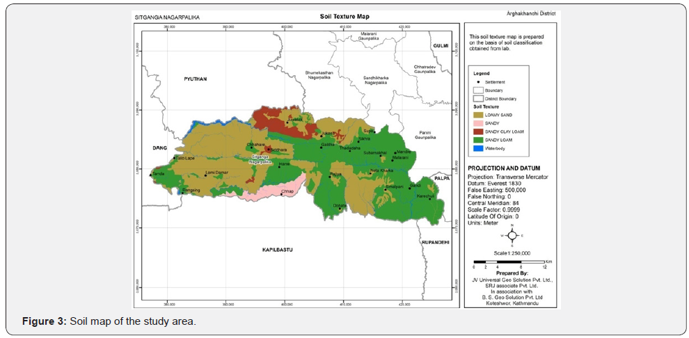
It is evident from the (Table 2) that three soil orders, three sub-orders, four great groups and four sub-groups of soil types of the municipal area were found based on the morphological, chemical and physical properties of soil acquired from the soil study by digging the soil pits and soil mapping unit level. Considering genetic horizons and soil properties, loamy sand, sandy loam, sandy clay loam and sandy types of soil found at the sub group level. Based on soil taxonomy system, the incept soils occupied 49.83% followed by entisoils (31.82%0 and moll soils (15.94%). Based on soil properties such depth, genetic horizons, and fertility characteristics, organic matter on the top soil found medium to low which indicates poor nutrients in soil (Figure 3). Regarding the soil pH, most of the soil was acidic to slightly acidic and some neutral. The quantity of nitrogen and phosphorus in soil found low to medium while the amount of potassium fount medium to high. Over all the soil in the entire area of the municipal area is less developed and marginally suitable for intensive agriculture and suit for forest and agro forestry practices. It shows that soil fertility assessment has to be the first priority of the local government to maximize the benefits from land resources.
Present Land Use and Land Use Zoning
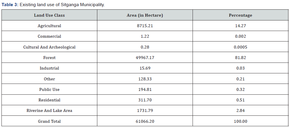
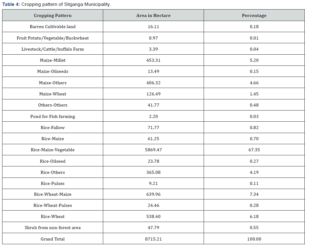
Regarding the existing land use pattern of the municipal area, nine land use classes were observed land use practices in which forest covers 81.82 percent followed by agricultural area (14.27%), riverine and lake area (2.84%) and residential area (0.51%) respectively (Table 3) shows that the municipal area has dominant forest area which is gradually decreasing day by day. The entire agricultural land of the municipality has classified as hill cultivation. The hill cultivation is further sub divided into different classes. All of the agriculture land of the municipal area found level terraces cultivation. Similarly, all the agricultural land is falls under level terraces Khet land cultivation analysis of cropping pattern shows the Rice-Maize-Vegetable is the dominant (67.35%) followed by Rice-Wheat-Maize (7.34%) and Rice-Wheat (6.18%). The cropping pattern of the municipality is presented in (Table 4).
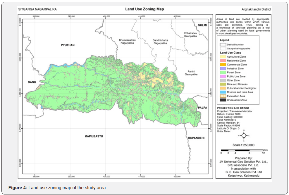
Land zoning as a technique of land use planning that used by the local based on official zoning record which separate one set of land uses from another. So that land zoning is dealt how local institutions use of specific parcels of land and provides predictability for the residents and development community as to what type of land uses may be expected and allowed within given municipal area. Land area of the municipality has divided into different zones on the basis of land capability and suitability analysis. The zonation of land is further supported and regulated by specific regulations which ensure designated use of each particular zone based on arability and productivity of soil without degradation or offsite effects of farming. The municipal area has forest as a dominant land use type followed by agriculture, water bodies (riverine, ponds, and lake) residential, and public use area. The industrial area is in insignificant level especially in the most western corner of the municipal area. Commercial area is in increasing trends basically in the corridor of the Gorusinge- Sandhikharka Road but with very little area. The agricultural area seems to be decreased while zoning. This is due to the allocation of the spatial area for new residential and commercial zone in the existing agricultural land. Similarly, forest area is further increased while zoning because of the bushes of barren land and riverbank shrubs are included into forest area.
Considering, hazards and risk factors for zoning, residential and commercial zones are allocated in such land which are under no or low risk areas. Most of the agricultural area is in slopping terraces of Chure and Mahabharata range that of geo morphologically unstable and would face severe soil erosion and landslides. It needs to well manage by using bioengineering technology. Most of the area of the municipal is covered by hills, foothills and steep slope area with rich biodiversity. Different types of herbal and medicinal as well as fodder species of plants are found in the municipal area. . Around 15 percent forest area in the river basin and lowland area subtropical Sal dominant forest exists. So, that there is a need to promote NTFPs and medicinal plants for the sustainable management of forest resource with livelihood improvement of the local people. It can also help to mitigate the land gradation through soil erosion, landslides and river bank cutting in the fragile geology and unstable geomorphology of Chure region.
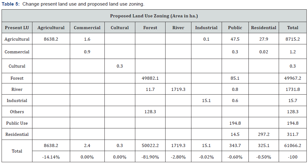
Using multi criteria analysis method different potential land use zones have been allocated under low risk. To allocate agricultural land for new residential and commercial area, land capability data were analyzed and suitability analysis was done. Land of marginal utilization with low capability of agricultural production has allocated for residential and commercial area as far as possible. In some cases, due to the unavailability of unproductive land and/or lower suitability of such land, some productive lands have been proposed as residential and commercial area in smaller extent (Table 5) clearly depicts that land use zoning exercise has allocated maximum area for the forest (82.90%) followed by agriculture (14.14%), riverine and lake (2.80%), public use (0.6), residential (0.5%), industrial (0.2%), commercial (0.004%) and cultural (0.001%). While the mining and extraction zones have not been allocated due to the lack of data with proper location. It shows that most of the forest land in the land Capability category forest IIICM with high potential of agro forestry, NTFPs and medicinal and herbal plant cultivation with drainage deficiency. The soil of the Nagarpalika is under nutrients and less developed. Organic matter, nitrogen, and phosphorous quantity in soil are also in low and medium range. It is evident that the agricultural area is decreased by 77 ha while zoning. The main reason behind this is allocation of new sites for residential and commercial use. Around 28 ha of agricultural land have been additionally allocated for new residential site and 1.6 ha for new commercial site. Similarly, the second reason is the right of way of road, which is currently under agricultural land, is now allocated as public use zone. This land is about 47.5 ha (Figure 4).
Conclusion
Topographical features (slope), soil parameters (depth, texture, drainage, pH, OM, N, P, and K), climate, land degradation and land management conditions of the municipality provide evidences to say that the entire municipal area is dominated with arable class III land having deficiency of soil rooting depth, drainage deficiency with very limited land of capability Class I Ah/1 which is potential for the diversified agriculture. There is a biophysical limitation to increase in class number of land capability due to stoniness, poor drainage, salinity/acidity, flooding, erosion, and soil depth for the use of land in sustainable manner. The risk assessment shows that the municipal area locates in moderately to steeply sloping mountain terrain and steeply to very steeply sloping mountain terrain having high chances of landslides, soil erosion, mudflow that increase the land degradation and fragility of the unstable geology of the Chure. Climate change impacts apparent particularly in the crop calendar and land, water and forest resources degradation and subsequently adverse effects on livelihood of the local people in the entire area of the municipality. Large part of the municipality local communities depends on harvesting forest products for their livelihoods. They collected their necessary forest products from government forest and community forest. But, they are far behind for the conservation and sustainable use of forest resources due to their attitudes towards the role and responsibility of common property resources conservation and management. The purpose of an integrated approach to planning the use and management of land resources is to make optimal and informed choices on the future uses of the land. This can be achieved through interactions and negotiations between planners, stakeholders and decision-makers at national, provincial and local levels based on efficient, comprehensive data management through a network of nodal institutions. Such data should be output in an understandable and userfriendly format that enable all stakeholders to co-decide on the sustainable, equitable and economic use of the land and follow it through to successful implementation.
An integrated and multi-disciplinary approach to the planning, development and management of land resources is as a process which methodically identifies human and environmental needs, the potential and options for change and improvement, identifies and evaluates all relevant physical, social, economic and policy factors, and develops a series of actions necessary to permit and facilitate the changes. The process needs to address an array of cross sect oral issues such as the creation of productive employment, the eradication of poverty and responses to pressures on the land caused by poverty, unsustainable consumption and production, population growth, and changing demographic patterns. Clarification and security of land rights, possible involving land tenure and ownership reforms are central to the solution of these problems. A holistic approach to the management of land resources requires the integration of land and issues of water resources as they relate to land use. A mismanagement of land and water often leads to land degradation through erosion, flooding, water logging and salinity and the depletion of water resources. The demands by municipal communities for land and its associated forest and water resources would often conflict if not properly managed. Where new economic carriers are considered necessary for sustainable development of the municipal areas, government initiations should be designed to include activities such as ecotourism, joint herbal and medicinal plant species management with local communities, joint forest management with local communities, watershed management (with upstream conservation funded by downstream beneficiaries of more regular flows, reduced silt load, and improved water quality), and nature reserves and parks (with employment generated by the policing function). More specifically, local government needs to promote indigenous knowledge based economic growth throughout the economy to allocate public expenditure to health, education and infrastructure.
Acknowledgment
This work is supported by the National Land Use Project for the preparation of municipal land resource maps, data base and reports. Special thanks go to Prakash Joshi and Samir Koirala for their advice and supports.
References
- SADC/SACCAR (1994) Guidelines for land evaluation for land use planning in the SADC Region. In: Proceedings of a Regional Workshop in Windhoek, Namibia. SADC/SACCAR Land and Water Management Research Programme, Gaborone, Botswana.
- FAO (2017) Voluntary guidelines for sustainable soil management. FAO, Rome, Italy.
- Schwärzel K, Ardakanian, R Avellán T, Zhang L (2016) Nexus approach: resource management for soil productivity. In Encyclopedia of Soil Science, Lal R (Eds.), (3rd edn), CRC Press: Boca Raton, Florida, USA, pp. 1530-1534.
- Zhang L, Schwärzel K (2017) China’s land resources dilemma: Problems, Outcomes, and Options for Sustainable Land Restoration. Germany: United Nations University Institute for Integrated Management of Material Fluxes and of Resources (UNU-FLORES), 01067 Dresden, Saxony, Germany 9(12): 2362.
- Saskia D, Keesstra, Johan Bouma, Jakob Wallinga, Pablo Tittonell, et al. (2016) The significance of soils and soil science towards realization of the United Nations Sustainable Development Goals. Soil-journal 2(2): 111-128.
- Smith P (2012) Soils and climate change. Curr Opin Environ Sustain 4(5): 539-544.
- Jansen B, Kalbitz K, McDowell WH (2014) Dissolved organic matter: Linking soils and aquatic systems. Vadose Zone J 13(7).
- Joosten H, Sirin A, Couwenberg J, Laine J, Smith P (2015) The role of peat lands in climate regulation. In Peatland restoration and ecosystem services. Bonn A, Allott T, Evans M, Joosten H, Stoneman R (Eds.), Cambridge University Press, Cambridge, UK.
- National Planning Commission (NPC) (2014) Nepal human development report 2014: Beyond geography, unlocking human potential. Kathmandu: Government of Nepal National Planning Commission.
- World Reference Base for Soil Resources WRB (2014) The international soil classification system for naming soils and creating legends for soil maps. Rome: World Soil Resources Report 106. Published by Global Soil Partnership, International Union of Soil Science and Food and Agriculture Organization (FAO) United Nations, USA.
- National Land Use Project (NLUP) (2015) National land use policy, 2075. NLUP/MOLRM/Government of Nepal, Kathmandu, India.
- Pokhrel KP (2013) Chure forestry conservation and management plan: A case study of Arghakhanchi district, Nepal. Journal of Geography and Regional Planning 6(5): 172-183.
- Ministry of Agricultural Development (MOAD) (2017) Statistical information on Nepalese agriculture 2015/2016. Kathmandu: Agri Statistics section, MOAD/GON, Nepal.


