Minimizing Vehicular Traffic via Integrated Land use Development: a Heuristic Optimization Approach
Babu Veeregowda1* and Rongfang2
1Vice President,NortheastDivision Chief Engineer, USA
2Professor of transportation engineering, New Jersey institute of technology, USA
Submission: June 22, 2017; Published: July 26, 2017
*Corresponding author: Babu Veeregowda, Vice President,Northeast Division Chief Engineer,Empire State Building 350 Fifth Avenue, 57th Floor New York City, NY 10118,USA Tel: (212) 695-5858; Fax: (212) 971-7239; Email: bveeregowda@vhb.com
How to cite this article: Babu V, Rongfang .Minimizing Vehicular Traffic via Integrated Land use Development: a Heuristic Optimization Approach. Int J Environ Sci Nat Res. 2017; 3(5): 555622. DOI: 10.19080/IJESNR.2017.03.555622
Abstract
The current traffic impact assessment methodology and environmental quality review process for approval of land development project are conventional, stagnant, and one-dimensional. The environmental review policy and procedure lacks in providing the direction to regulate or seek alternative land uses and sizes that exploits the existing or surrounding elements of built environment (“4 D's” of development - Density, Diversity, Design, and Distance to Transit) or smart growth principles which influence the travel behavior and have a significant effect in reducing vehicular traffic. Additionally, environmental review policy does not give directions on how to incorporate urban planning into the development in ways such as incorporating non-motorized roadway elements such as sidewalks, bus shelters, and access to community facilities.
This research developed a methodology to optimize the mix of land uses and sizes using the heuristic optimization process to minimize the auto dependency development and to meet the interests of key stakeholders. A case study of Willets Point Mixed Use Development in Queens,NY, was used to assess the benefits of the methodology. The approved Willets Point Mixed Use project was based on maximum envelops of size and land use type allowed by current conventional urban renewal plans. This paper will also evaluate the parking accumulation for various land uses to explore the potential for shared parking to further optimize the mix of land uses and sizes. This research is very timely and useful to many stakeholders interested in understanding the benefits of integrated land uses and its development.
Introduction
The American Planning association defines Smart Growth as the principles that support choices and opportunity by promoting efficient and sustainable land development based on the surrounding built environment. Smart Growth allows professionals to evaluate the transportation effects of Smart Growth Development, and to identify potential site-plan refinements that will further reduce its traffic impacts. Many communities across the United States have begun implementing various “smart” development programs such as higher density development, context sensitive development, transit oriented development, and mixed use development to alleviate traffic congestion. However, research shows that none of the above“smart”programs can be successful without a “balanced or optimized “mix of land uses and sizes that are mutually conducive, beneficial, and integrated with the surrounding urban context [1]. “Smart” developments that make use of the principles of Density, Diversity, Design, and Distance (FourD’s) reduce generated traffic, are beneficial to the environment, and increase the safety, comfort, and benefits to the health of citizens. At the same time, developments that use the four D 'reduce the need to build additional infrastructure to mitigate environmental impacts like vehicular delay, air and noise, parking, transit, and bus.
Current traffic impact assessment methodology, used as part of the environmental impact review process for approval of a project, is stagnant and one-dimensional. It does not consider the optimization of land uses and sizes based on the elements and variables of the surrounding urban context. The review criteria is largely centered on automobile traffic and does not incorporate measures related to access to public transportation or design features that promote non-motorized modes or recent preference to shared mobility. The objective of this research is to develop a methodology that optimizes the mix of land uses and sizes that is practical, easy to explain, and readily implementable. Applying a heuristic optimization process using Genetic Algorithm (GA), the study aims to minimize vehicular traffic and environmental impact without sacrificing economic returns on investment. A case study based on the current zoning and urban renewal plan for Willets Point Development, a mixed used development in Queens, NY approved by the government agency and it is the process of being developed, will be used to assess the benefits of the integrated land use and smart growth principal in urban settings.
The methodology was created by doing the following:
a. Conducting methodological travel behavior, trip generation, and 24/7 parking accumulation surveys by land use type
b. Analyzing travel behavior as a multi-level phenomenon, with trips nested within surrounding built environment and surrounding built environment nested within the 4 D's
c. Analyzing parking accumulation characteristics of various land use types and shared parking between land uses
d. Optimizing the mix of land uses and sizes based on the surrounding built environment and shared parking opportunities between the land uses to reduce the auto dependency
e. Measuring the effects of optimized mix of land uses and sizes on auto trip generation and qualitative assessment of environmental impacts compared to already approve case study.
Literature Review
Conventional Traffic Impact Studies and their Shortfalls
Although there are stringent environmental review processes required by many agencies for approval of a land development or land use rezoning, as previously mentioned, not enough emphasis is currently placed on sustainable developments that rely on the available public transportation systems or assets and non-vehicular modes of transportation. Additionally, the traffic impact guidelines do not recommender have guidelines for techniques used for assessing consequences of alternativel and uses or optimizing the sizes of land use son the transportation systems, development, and community. Optimized mixed used envelopment with a high internal trip capture that integrates urban designs part of the development program and supports non-motorized trips, such as walking and bicycling, would have a huge impact on reducing congestion [2].
Numerous studies and available evidence suggest that "smart" development programs and a well-integrated mix of land uses and sizes with the surrounding can reduce peak period traffic at many sites by asmuchas10%to15% Meyer and Miller (2001). Several studies further indicate that a development with an optimized mix of land uses and sizes can reduced riving dependency by 20% to 40% [3,4]. Despite the sere search findings, there are limited guidelines for prescribing a methodology of selecting development alternatives that are balanced and that optimize the mix of land uses and sizes in a way that limits the vehicular demand while maintaining a high number of person trips attracted to the development, thereby ensuring economic success.
The current trial and error methodology to optimize them in of land uses and sizes is in he recently cumber some, time consuming, costly, and rarely results in an optimal out come. There are many cases in the past where developers or investors have had to abandon land development projects in the middle of the environment all review process because of expensive mitigating impacts or a lower turn on investment due to the loss of valuable land to parking, storm water management, or open space requirements [5]. Therefore, an extol used during the initial planning's tags that optimizes them of land uses and sizes while comparing trip generation from various mixed land uses is needed of in the best land use development envelope [6].
Shortfalls of Current Optimization Techniques
There are a number of studies in regards to land use allocation using optimization techniques. Most [7-10] have dealt with objectives like maximizing land use compactness, improving compatibility among neighboring land uses, and ensuring suitability of land units for land uses without considering the travel behavior. Most of these models do not take built environment into account and are linear with quadratic objective functions with too much detail in setting the objectives and constraints to provide realistic solutions. This generally makes the model computationally intractable, more narrowly defined, and therefore less useful. A review of the abovementioned studies found that multiple objectives combined into one were used using different weights to find the trade-off solutions. There is an argument that the weighting technique is very unlikely to generate a significantly different land use arrangement that might help different stakeholders [11].
The four main classes of stakeholders to be considered are considered four main classes of stakeholders: the agency planner, the environmentalist, the conservationist, and the land developer [12]. Their objectives, which related to compactness, imperviousness change, environmentally sensitive areas, and profit making, are restricted by land growth and zoning. Unlike the above studies, the optimization of mix of land uses and sizes are non-linear since each land use's modal split or auto generation behavior is dependent on its relationship with the surrounding built environment, internal trip caption rates between land uses, competing needs and objectives of various stakeholders, etc. A non-linear optimization model can be defined as a way of maximizing (non-motorized trips) or minimizing (auto trips and environmental impacts) an objective function by including a set of unknown real variables (types of land uses and its sizes) subject to certain constraints to meet the objectives of key stakeholders such as agency planners, environmentalists, conservationists, and developers.
Integrated land use principles and overall discussion of optimization of mix of land uses and sizes
In order to create a well-balanced or optimized mix of land uses and sizes through the core principle of "smart" development, it is first import of and the travel demand characteristics of various land uses such as person and vehicular trip generation characteristics, 24-hour person and vehicular trip generation,temporal distribution, modal split, internal linkage, vehicle occupancy, and parking accumulation characteristics of land uses. These factors are highly dependent upon the context of the surrounding or attachment area that is listed in the Four D's of the planning principles that is discussed in the introduction. For example, given there is a good public transportation system, are all and use would tend to attract more person tripsvian on- motorized or public transportation systems over a destination retail or a convention center.
However, to meet the goal of various stake holders, land uses that may not be advantageous from local context perspective may need to be considered. But the goal of “smart” development can still be met by optimizing the mix of land uses and sizes by exploiting the relationship between the travel behavior based on the surrounding built environment(4 D's) and local context. Secondly, optimization of the size of various land uses based on trip characteristics of various land uses is crucial in coming up with “smart” development. Trip character of various land uses depends up on its 24-hour trip generation, temporal distribution, modal split, linkage trip, and vehicle occupancy-a multi variable optimization. Many techniques are available that assist in developing an optimized land use sizes as Linear Programming and Multiple Regression.
Based on an extensive literature review, it was concluded that most of these commonly used optimization techniques perform well as long as there quirements are linear, structured, and efficient only when one single objective is clearly identified Stewart 2004.Thirdly, the Integrated Land Use (ILU) should also take the parking utilization character of each land use into consideration. Parking demands operate on a peak and off-peak schedule depending on related land uses. Distinct but complementary patterns, such as "office parking" that is generally empty in the evenings and on weekends and “residential parking” that is generally fuller in the evenings, offers an opportunity for cities to better satisfy residents and commuters without increasing the supply. Shared parking is a land/development strategy that optimizes parking capacity by allowing complementary land uses to share spaces, rather than producing separate spaces for separate uses. According to Institute for Transportation and Development Policy, shared parking can reduce parking requirements by 20-40%, creating positive economic, social, and environmental benefits.
Non-linear Optimization Model
Section 2.3 under the literature review explained the shortfalls in the current studies and research pertaining to smart growth as well as the reasons why the optimization of mix of land uses and its sizes are non-linear in meeting the goals of smart growth. The maximization model can best agendas:
maxf(x) s.t.x ϵ F,
where f(x) is the given objective function defined for some feasible region F⊆Rn. The generation of alternative solutions to this problem is also possible with relevant changes in the constraints. Once it is a multi-objective decision problem with q objectives, the formulation can be expressed as
max {f1x) ... fq (x)}
s.t xϵ F and FeRn
The multiple objectives of optimization of mix land uses and size based on travel demand factors that minimize the auto trips and maximize the person trips are combined to form a single-objective function using the scalarization technique, and optimized subject to the same constraints. Wb is the ratio of vehicle trips by land use b to area of land use land b; fb is ratio of person trips of land use b to area of land use b.

The advantages and disadvantages of both methods are reported in several studies [12,13]. Here, a scalarization method is more applicable as it is simple, easy to implement, and reasonably enumerates a single goal of all the key stakeholders mentioned above that is more suited for Smart Growth.
Land Use Allocation model
The non-linear formulation of the models that relate to a huge combinatorial optimization problem has compelled us to search for a heuristic approach like GA. For this research, wear using an already approved mixed used envelopment as our case study where i (i=1,2,...,N)is the number of land uses, Hi is the total number of trips by the land use i, h (h =1, 2,..., Hi) is each land use size, and m (m =1, 2,..., K) is the allowed upper and lower bounds of land use i. Our aim is to arrive at an all ocation of size h (h = 1, 2,..., Hi) for land uses that minimizes the auto trips based on the travel behavior (modal split) by keeping the number of total person trips and total size of the development same as approved case study.With this notation, the objective can be expressed in general as 0 ≤Xim≤1. This research strategically combines the land uses and size based on traveled and factors using the scalarization technique to form a single-objective function. In the past, such integrations were under taken to produce computationally tractable solutions by using the single objective function of the GA [7,14]. As part of this proposed methodology, the author developed a model successfully through this research using the approved case study which optimizes the mix of land uses and sizes based on the travel behavior (modal split) to reduce the vehicular trips while keeping the person trips and overall built up area same as the status quo - a win-win situation from the principles of Smart Growth, financial and meeting competing goals of various stakeholders.
Case study: willets point mixed use development
Typically land use development happens from concept level to its approved plan, which is based on the current zoning and a urban renewal plan where land uses and sizes are determined based on the maximum envelop of size and use type the current zoning or Urban Renewal Plan allows. The consultant who performs the environmental impact study assessment for a project is based on the plans that were given and the methodology prescribed under the agency's prescribed environmental assessment guidelines. The prescribed methodologies are conventional and does not seek alternative land uses and sizes that exploits the existing or surrounding elements of built environment ("4 D’s” of development - Density, Diversity, Design, and Distance to Transit) or smart growth principles.
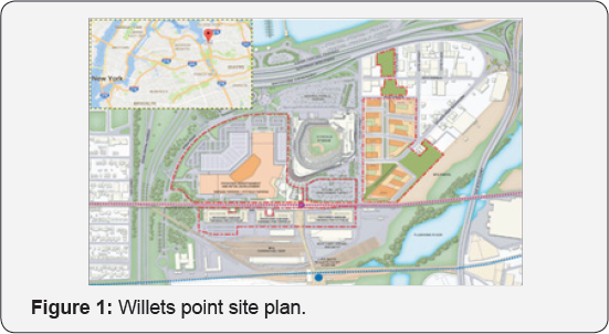
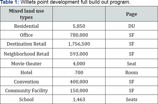
The environmental assessment for Willets Point Mixed Use Development was done based on NYC's City Environmental Quality Review Technical Manual Guidelines [15]. The approved Willets Point project located in Queens, NY (Figure 1) will be built in three phases. Upon completion, the full build-out of the District is anti cipated to total approximately 10.3million square feet (sf) of development with various land use types as shown in (Table 1) below. As part of the study, massive data collection was conducted which included turning moving counts, 24-hr automatic traffic recorders, vehicle classification counts, pedestrian counts, speed and delay runs, and levels of service observations at over 30 key intersections and also at two interstate highways encompassing the study area for seven time periods during the weekday (game and non-game) and weekends (game and non-game) conditions.
These extensive data collection and analyses were undertaken to assess the traffic and environmental impacts due to proposed project. The authors will apply the methodology that was developed through this research to this case study to assess the benefits of applying the principles of smart growth and integrated land use development.
Summary of Site Specific Trip Generation Estimates, Associated Impacts, and Mitigation Measures
The study used a travel behavior data was based on the extensive patronage interviews, door counts, and approved past studies for similar and comparable land uses in the study area. It is import antidote that each land use has different percentage of trips made by auto mobile, transit, rail, and non- motorized trips such as walking or biking, including the link trip or internal capture. For example, there side entail and use has a modal split auto mobile(26%), subway (52%), bus(10%), and walking(11%), while hotel has a modal split of auto mobile(70%),subway (5%),bus(5%),and walking(5%). Some of the land uses such also cal retail and recreation all uses have link trips(25%), which do not generate new trips. Similarly, Office use has the lowest auto mobile occupancy (1.14%), and Movie the after has the highest (2.52%).
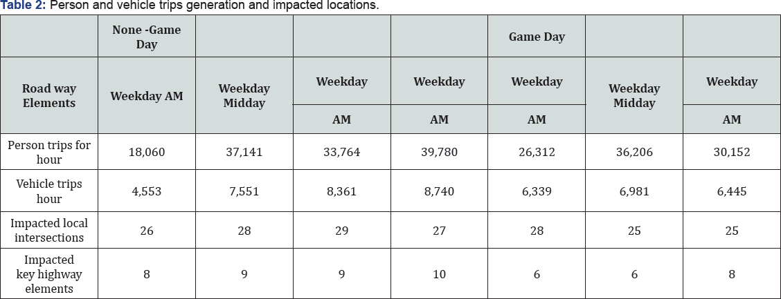
Table 2 shows the volume of person trips and vehicle trips expected to be generated under full build-out during each studied peak hour. A detailed traffic impacts analysis was performed for seven time periods during the weekday (game and non-game) and weekend (game and non-game) conditions at over 30 local intersections and two interstate highway corridors (with 16 key highway elements) surrounding the study area. The multiyear study shows that the majority of studied intersections and highway locations will be significantly impacted in spite of building on/off ramps to/from the surrounding highway to provide direct access to the project site while avoiding the local roadway network.
Most of the impacts were mitigated using non-cost intensive transportation system management measures such as signal timing and phasing modifications, modifying the lane channelization, increasing roadway capacity, etc. and cost intensive measures such as adding a lane, installing a traffic light, modifying the intersection and roadway geometric design, This was all done in addition to building on/off ramps to the surrounding highway as part of the project (build condition) to avoid traffic localized travel and subsequent impacts.
Optimization of Mix Of Land Uses And Sizes
The key stakeholders on any land development in urban settings are agency planners, environmentalists, conservationists, and land developers. Typically their concerns, respectively, are compactness or scale of the development per zoning, change to the environment such as wetlands, green spaces, etc., environmentally sensitive issues such traffic, air quality, and noise, and profit or return on investment. The common denominator for all these objectives is minimizing the number of vehicles and maximizing the number of person trip generation. Using the scalarization technique, the auto trip curve and the person trip curve of the generators have been combined to form a "unified" function (Table 3).

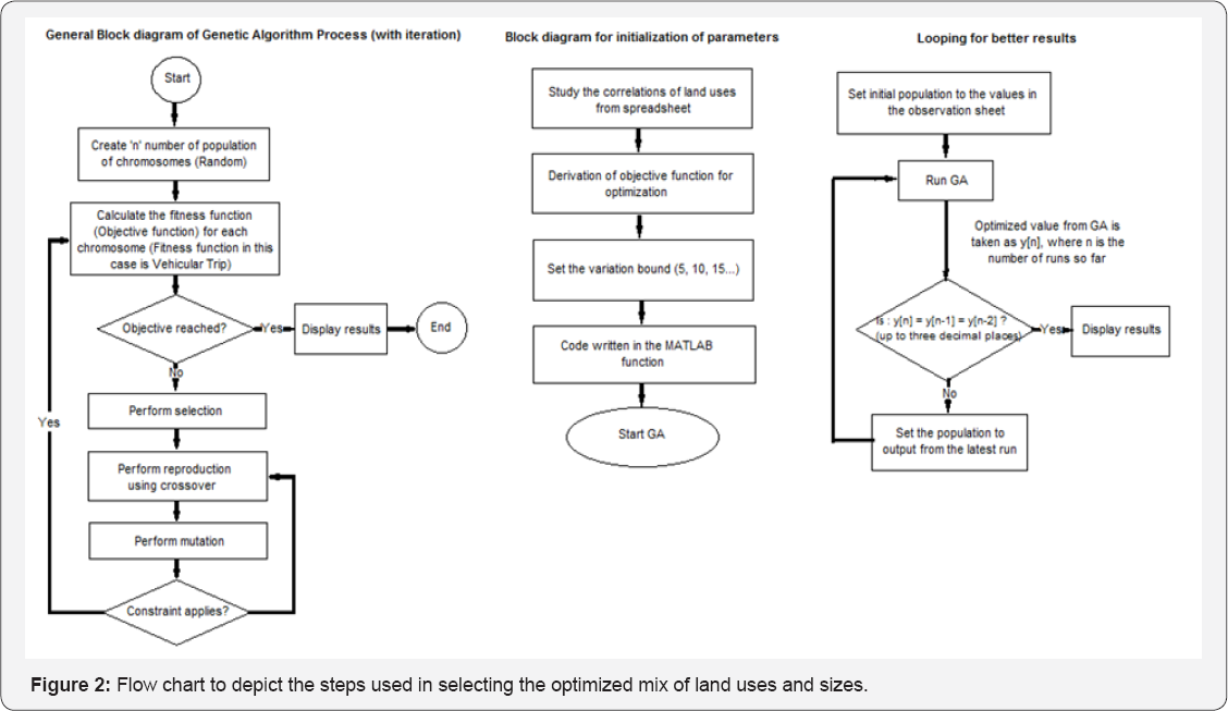
This is done effectively by strategically linking the various trip generation characteristics of each land use in conjunction with other land uses while keeping the fundamental phenomenon of the single objective optimization, reduce the number of vehicle trip generation in mind. Lower bound that could be potentially allowed. Since+/-5% to+/-50%is considered to be the acceptable range in the land development industry while selecting the land uses that are fail proof during the economic down turn, a total of10 scenarios were considered(5,10,15,20,25,30,35,40,45,and50). Under each percentage scenario ,a GA optimization was applied as per the methodology that is developed in section 3. The optimization methodology uses “hill-climbing” approach while the size was varied incrementally between the specified bounds for each land use. Each scenario will have multiple. As each run progress, the total number of auto mobiles generated by all land uses decreases while maintaining the same number of person trips as the case study. Figure 2 below shows the steps involved in formulation, heuristic search and optimization, and looping technique for better computation and search in developing an optimized mix of land uses and sizes.
Findings Of The Methodology: Benefits Of Optimizing The Mix Of Land Uses And Sizes

The methodology that was developed above to optimize the mix of land uses and size is very effective in reducing the overall vehicular trip generation (Table 4). The approved site plan has 5,850dewelling units, 780,000 sq.ft of office, 1,757 Sq. ft of destination retail, 593,000 sq.ft of retail, 400,000 sq.ft of convention center, 4000 seat (20 sq.ft per seat or a total of 8,000 sq. ft) cinema, 700 rooms (800 sift per room or a total of 560,000 sq.ft), 150,000 sq.ft community center, and 1,463 seat school (157.2 sq.ft per seat of or a total of 230,00sq.ft).
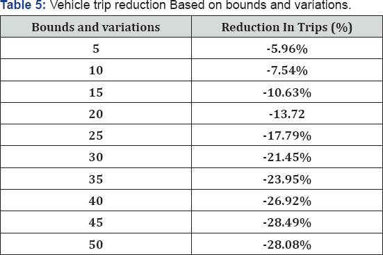
The travel demand estimates of the case study, as a status quo project, show that it would generate a total of 33,764 person trips and 8,361 vehicle (auto, taxi, and delivery) trips during the weekday PM peak hours. Table 5 summarizes the total trip generation when the optimal solutions plateau for each bounds and variations. shows that 5%, 10%, 15%, 20%, 25%, 30%, 35%, 40%, 45%, and 50% bounds and variations of mix of land uses and sizes shows the reduction of vehicle trip in the range of 500 to 2,350 vehicles during the PM peak hour by keeping the person trip and total built up area to maintain the financial returns same as the case study. The reduction in vehicular trip generation will minimize the traffic impacts, environmental impacts, vehicle miles travel, and also cost of the additional infrastructures to mitigate project related impacts. The results also show that as the bounds and variation increases the reduction in the vehicle trip generation by the development increase. This gives options to stakeholders to pick and choose bounds and variations and its corresponding mix of land uses and sizes based on vehicle trip reductions and compare it to the status quo development Parking.
The parking survey were conducted for various land uses to estimate the parking accumulation throughout the day Parking accumulation for various land uses were looked independently outside the optimization of mix of land uses and sizes. The parking accumulation for select land uses as an example. The temporal distribution of parking accumulation shows there is plenty of opportunity to leverage the need for parking spaces by allowing complementary land uses to share spaces, rather than building separate spaces for separate uses. The study is underway to integrate shared parking techniques and methods between the land uses into optimization of mix of land uses and sizes methodology discussed earlier. When the study is completed, it will help guide planners and developers of mixed-use projects with design features likely to minimize traffic generation, need for parking spaces, and environmental impacts such as traffic delay and congestion, greenhouse gas and energy impacts. Only through smart calculations informed by studies like ours can planners and engineers begin to put in place strategies that reward smart growth.
Conclusion and further Recommendations
As mention earlier, this research considers the two key element soft he land development that are largely over looked in current research and studies: travel demand factors and competing needs of various to holders. The methodology that was developed to overcome some of the short falls in current research was effectively applied to the case study described earlier. As a result, this research reveals three important things: consideration of travel demand factors in the optimization of the mix of land uses and sizes reduces auto trips while keeping the person trips and over all built up area same as the status ) multi- objectives of land used envelopments can become binned or unified systematically into a single-objective function, without loss of generality, to develop multiple tractable solutions to meet the goals of Smart Growth that can be easily understandable by all stakeholders and although there results of the above methodology supports that optimizing land uses and sizes based on travel demand factors would create as mart development that is less auto-dependent and requires fewer parking spaces, examination of their results of each optimized scenario in detail suggests that each optimized scenario may not be fully optimized in terms of parking demand. It suggests that further evaluation of overall parking occupancy of each optimized scenarios required based on the parking accumulation characteristics of each land use and its potential for "parking sharing” between each land uses.
This research show that a well-integrated land uses and sizes to complement the surround travelling behavior based on the surrounding built environment ("4 D's”) reduces the number of auto trips while attracting the same amount of person trips,ultimately creating infrastructure that is both environmentally responsible and financially profitable in congested urban areas.
References
- Hamid I, Mirhoseini A, Rasoolzadeh M (2014) Understanding the Role of Built Environment in Reducing Vehicle Miles Traveled accounting for Spatial Heterogeneity. Sustainability 6(2): 589-601.
- Littman T, (2016) Land Use Impacts on Transport: How Land Use Factors Affect Travel Behavior. Victoria Transport Policy Institute.
- Bartholomew KR, Ewing (2009) Land Use-Transportation Scenario Planning: A Meta-Analysis, Journal of the American Planning Association 75(1): 13-27.
- Ewing E, Cervero R (2010) Travel and Built Environment, Journal of American Planning Association 76( 3).
- Litman T, Parking Management, startegies, Evalaution and Planning. Victoria Transport Policy Institute.
- Foytic P (2011) Using Genetic Algorithm to Estimate the Parameter of Volume Delay Function, Transportation Research Board 90th Annual Meeting.
- Aerts JC J, Eisinger E, Heuvelink ,Stewart TJ (2003) Using Linear Integer Programming for Multi-Site Land- Use Allocation. Geographical Analysis 35(2): 148-169.
- Berke P, Godschalk D (2006) Urban Land Use Planning, Fifth Edition, 5 th edition, University of Illinois Press.
- JiangPing W, Quinn T (2009) urban planning decision using multiobjective optimization, Operational Research 185(3): 1192-1212.
- Ligmann Z A, Church R, Jankowski P (2005) Sustainable urban land use.
- Ligmann Zielinska A, Church RL, Jankowski P (2008) Spatial optimization as a generative technique for sustainable multiobjective land-use allocation, International Journal of Geographical Information Science. 22(6): 601-622.
- Gabriel S A, Faria J A, Moglen G E (2006) A multi objective optimization, approach to smart growth in land development. SocioEconomic Planning Sciences 40(3): 212-248.
- Mattson CA, Messac A (2002) A Non-Deterministic Approach to Concept Selection using s-Pareto Frontiers, Proceedings of ASME DETC Design Engineering Technical Conference and Computers and Information in Engineering Conference, Design Automation Conference, Multi objective Optimization, Montreal.
- Haque A, Asami Y (2011) Optimizing urban land use allocation: case study of 388-410.
- http://www.nyc.gov/html/oec/html/ceqr/technical_manual.shtml.


