Weathering Processes Acting on Chalky Limestone Composing Geo Heritage at The White Desert, Farafra Oasis, Western Desert, Egypt
Gamal Kamh1*, Chiaki Oguchi2, Mohamed Abu El-Hassan3 and Wael Thabet4
1 Professor of Geoarchaeology, Department of Geology, Menoufiya University, Egypt
2Professor of Env Geol and Geological Sciences, Saitama University, Japan
3 Professor of Sedimentology, Department of Geology, Menoufiya University, Egypt
4 Head of Naturally Protected Areas, Western Desert Institute, Egypt
Submission: February 24, 2020; Published: March 18, 2020
*Corresponding author:Gamal Kamh, Professor of geoarchaeology, Geology Department, Faculty of Science, Menoufiya University, Shebeen El-Kom, Egypt
How to cite this article:Gamal Kamh, Chiaki Oguchi, Mohamed Abu El-Hassan, Wael Thabet. Weathering Processes Acting on Chalky Limestone Composing Geo Heritage at The White Desert, Farafra Oasis, Western Desert, Egypt. Eng Technol Open Acc. 2020; 3(4): 555616. DOI: 10.19080/ETOAJ.2020.03.555616
Abstract
Egypt is one of the most rich countries world–wide in its archaeological remains as well as the geological heritage that almost has not been discovered till now requiring much investigations through major projects under the umbrella of international institutes. Farafra Oasis and its surroundings in the heart of the western desert of Egypt, has some high geomorphic landforms of chalky limestone constitute an attractive geological heritage. The main aims of the current study are to investigate the weathering processes acting and developing the different landforms at the White Desert, grouping these landforms, and to find out the developing stages of Mushroom as one of the most common landforms at this White Desert. Field investigations including slope angle measurement on opposite sides of some landforms, measuring weathering depth and detection of weathering profile, sampling on both sides of some representative landforms as well as photo-documentation of the weathering features at these forms have been conducted. Laboratory investigations including testing rock’s mineralogy, geotechnical properties and durability to weathering have been conducted. The detailed field and laboratory investigations revealed that the rock at the White Desert is pure snow white chalk, it is salt resistant for the reference samples, altered by weathering to salt prone for the west facing side and very salt prone for the east facing sides’ samples of some representative landforms. Diurnal and seasonal contrasted climatic changes, wind-blown with medium size sand play an effective role in rock’s weathering at this desert.
Keywords:Geological heritage; White desert; Farafra oasis; Western desert; Egypt
Introduction
The Farafra oasis is one of ten major depressions lies in the heart of the western desert of Egypt [1] and [2]. It is located at about 140 km southeast of the Bahariya Oasis in the central part of the Western Desert (between 26o 45’ -27o 40’ N and 27o 00’- 28o 50’ E) [3] (Figure 1). The Farafra Oasis occupies an oval-shaped depression with an area of about 10,000 km2 [2,4]. On the bottom of the Farafra depression, the Dakhla Shale (Maastrichtian) is outcropped, and it is laterally inter-tonguing into the Maastrichtian Khoman Chalk in the central and northern parts of the oasis [3,5,6]. The Farafra Depression is surrounded by high escarpments, and its bottom rises gradually to the general level of the surrounding desert southward direction [1,5,7,8]. Geologically, the scarps of the Farafra depression are composed of the Tarawan Formation (Paleocene) overlain by the Esna Shale (Paleocene-lower Eocene) and the Farafra Limestones (lower Eocene) [5,9]. The Farafra depression forms a dome structure, which represents the southern extension of the Syrian Arc System [4], its axis stretches in the NE-SW direction.
The Maastrichtian (Late Cretaceous) chalky limestones had been intensively karstified in the Miocene [9,10]. The huge number of the geomorphological features permits judging the rank of the relevant geological heritage as national. The Khoman Chalk Formation (Maastrichtian, Late Cretaceous) at Farafra Oasis forms a distinctive geological feature that is mainly composed of snow-white chalk and chalky limestone with abundant chert bands and thin shale beds at top. This formation is ranging from 25-30m in thickness, and it overlies conformably the Hefhuf Formation (Campanian, Late Cretaceous) and underlies the Tarawan Formation (Paleocene) [7].
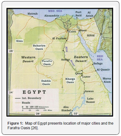
The White Desert (El-Sahara El-Beida in Arabic) is located ~45km to the north of the Farafra Oasis, and it has a total area of 3010km2, it has been declared as a natural protectorate in 2002, it has been named the White Desert because of the white color dominating its whole landscape [2,11,12]. The main aims of the current study is to investigate the weathering processes acting and developing the different landforms at the White Desert, classify these landforms into groups, and to find out the developing stages of Mushroom as one of the most common landforms at this White Desert. Also, it aims to qualify the relative rate of weathering on the different sides of some representative landforms at this desert.
Methodology
Field investigations
To achieve the aims of this study, detailed field investigations have been conducted through the following steps; surveying of the study area and measuring local temperature and relative humidity from one side to the other for the same landform, measuring sides’ slope angle of some representative landforms using Brunton Compass, sampling from the weathered and control “reference” parts at equal heights of some representative landforms, measuring the total height of these landforms regarding to its surrounding study area, measuring the weathering depth and weathering profile at the opposite sides of some representative landforms using a drilling device system (DDS) that works at a steady power and rotation velocity over a fixed testing time at each measuring point. Sampling from the sands surrounding the basal parts of these landforms have also been collected to be analyzed for their gain size distribution. The weathering forms noted on the surface of these landforms have been quantitatively reported (well described and their dimensions have been measured) to find out the damage category either from one form to the other or from the lower part to the upper part of the same landform.
Laboratory investigations
It has been conducted for the collected rock samples to find out the factors controlling rock’s susceptibility to weathering. These investigations include rock’s texture and mineralogical composition as well as rock’s geotechnical properties. The rock’s petrography and purity in composition have been conducted using a transmitting polarizing microscope, scanning electron microscope and acid insoluble residue test. The rock’s geotechnical properties, particularly pore size distribution “PSD”, are among the controlling parameters on rock’s susceptibility to weathering. So, some representative rock samples have been collected at the weathered and reference “control” parts of the landforms at this area of investigation. These samples have been examined using the Mercury Intrusion Porosimetry “MIP-5900” to find out their pore size distribution. The MIP results have been used to compute the Weathering Susceptibility Index “WSI” that represents to which limit does this rock is susceptible to weathering [13
The WSI has been computed using Yu & Oguchi [13] equation listed as follows:
WSI = (Ipc + Ipm0.1) (Pm5 / Pc) Where Ipc is index of total connected porosity; Ipm0.1 is index of micro-porosity of pores smaller than 0.1μm in radius; Pc is total connected porosity, and Pm5 is micro-porosity of pores smaller than 5μm in radius. The Yu & Oguchi [13] classification and interpretation of WSI (Table 1) has been used to interpret the results of this WSI achieved for the examined rock samples. Rock’s durability has also been quantitatively examined for the representative rock samples collected on opposite sides of the same landform as well as from one form to the other using dilute Hydrochloric acid “prepared by adding 20ml of concentrated HCl to one liter of distilled water” for six cycles following the method of Jefferson [14]. The samples’ weight has been recorded every two cycles of this test at dry state of these attacked samples. This will clarify if the rock samples, at the different sides of the same landform or from one landform to the other, have the same durability to a given attack “weathering” or not. Hydrochemical analysis for the extracted solutions prepared from the collected rock samples (following the method of Rhoades [15], at the weathered and reference “control” parts of these landforms has been conducted. This is to detect the rock’s total dissolved salts “TDS” that clarifies if salt weathering is one of the weathering processes acting at these landforms or not. As the climatic conditions at the study area is hot dry besides sand ripples circulate the basal parts of these landforms, then, sampling from these ripples and sieve analysis had been conducted for them and the results have been interpreted in relation to creation of these landforms.
Results
Field results
Landforms and the expected developing history at the White Desert
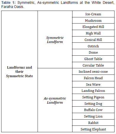
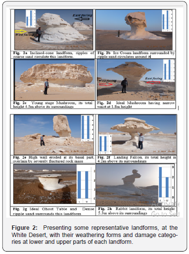
The landforms at the White Desert have not been previously described, classified and/or grouped. Consequently, detailed survey has been conducted throughout this White Desert concerning the different landforms, then, these forms could be classified and grouped into two groups “Symmetric and Assymmetric”. The Symmetric ones are those can be divided into two congruent halves by an imaginary plane and not that congruency for the as-symmetric ones. This classification has been listed in (Table 1) for some representative landforms photo-documented in the field (Figure 2a-2h). The field survey of the landforms at the White Desert enables an understanding of all steps of progress in Mushroom and some other landforms. Some major rock masses at this White Desert are eroded at its lower parts creating a broad neck (Figure 2c), that is more eroded creating a clear basal neck and appeared as rounded cylindrical neck (Figure 2d). Finally, the rock mass becomes highly mature Mushroom or other landforms looks like mushroom e.g. Landing Falcon (Figure 2f) with rounded or elongated rocky head above elongated cylindrical neck. This head may be fractured and lost its parts and altered to an Ice Cream form (Figure 2b) and then lost most of its head forming a High wall (Figure 2e) that is fractured later and probably totally fall down leading to demolish of the total landform by its alteration into rock debris. Differential weathering from one side to the other e.g. from East facing side to West facing side results in an inclination of the rock masses e.g. the Inclined cones and Sea waves landforms (Figure 2a). Not only that but also differential weathering from base to top of some rock masses creating a unique landform e.g. Setting pigeon, Ghost Table and Rabbit landforms (e.g. Figure 2g & 2h). Single and multiple scaling associated with creation of rock debris and karsts with micro-environment between the scales and the main rock body dominates as weathering phenomenon at most of landforms, cracking also noted with its geometries, densities and locations (Figure 2e & 2h).
General and Local Climatic Conditions at the White Desert
The climatic conditions have been collected from the Egyptian Meteorological Authority for the last 20 years at Farafra Oasis (Table 2). This monitoring duration is not enough for interpreting weathering of rock masses, at this white desert, compared with the geologic time scale through which these landforms have been created. But it throws light on the severity of weather acting at this area and guide the interpretation of weathering type prevailing at this area e.g. physical and/or chemical weathering; and its process e.g. windblown, solar heating. The local climatic conditions (air temperature and relative humidity) and duration of solar heating on both sides of each sort of landforms at this area have been recorded for days along Summer and Winter seasons to get the average values of these records (Table 3). This is to interpret the main reason behind differential weathering from one side to the other of the same landform resulting in Inclination of some of these forms (e.g. Figure 2a). It can be noted that the inclined landforms (that have gentle slope side facing the East direction and steep slope side facing West direction e.g. Inclined cone, Setting dog and Rabbit landforms) have higher average temperature and lower relative humidity on the East facing side compared with West facing side either on Summer or Winter seasons (Table 3). While the landforms that are vertical with uniform slope on all of its sides e.g. Ideal Mushroom and Ghost table, receive nearly equal average values of air temperature and relative humidity on both sides of it either in Summer or Winter season (Table 3). On Summer time, the solar duration on both sides is different particularly for the inclined landforms with longer duration on East facing side (that also receives higher temperature and lower relative humidity) compared with the West facing side (Table 3). This difference in duration of solar heating and its intense from one side to the other will explain the main reason behind inclination of some landforms at the white desert.


Damage Categories of the landforms
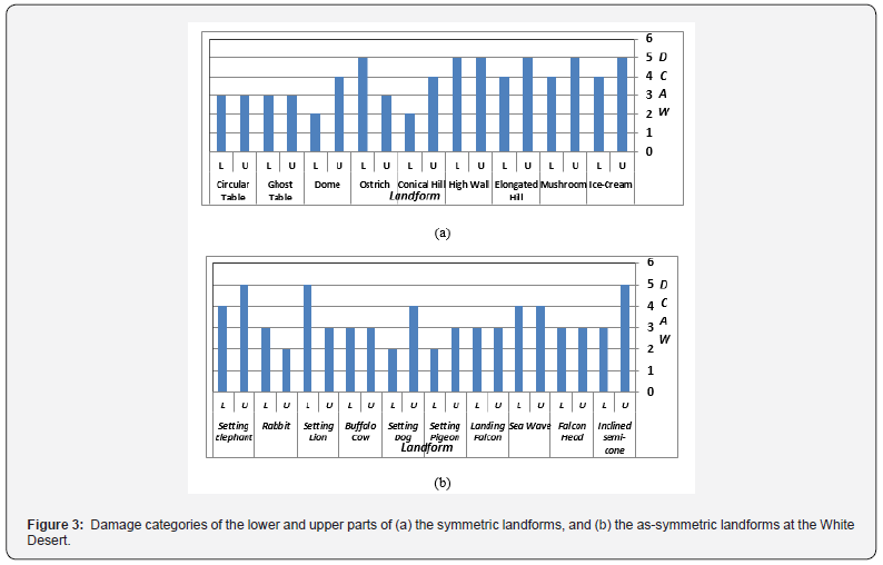
The field survey including photo-documentation of the landforms; considering the weathering forms (e.g. stone’s surface scaling, rock meal, disintegration, cracking) and their dimensions (e.g. thickness, area percentage covered by this weathering form, density) enabled determination of the rock’s damage category for a given part or the whole parts of the landform under investigation [16]. In the current study, this damage category has been defined for the lower and upper parts of some representative landforms at the White Desert using the damage category scale of Fitzner & Heinrichs [16] that is listed as follows:
Damage Category 0: No visible damage can be noted
Damage Category 1: Very Slight damage can be noted
Damage Category 2: Slight damage can be noted
Damage Category 3: Moderate damage can be noted
Damage Category 4: Severe damage can be noted
Damage Category 5: Very severe damage can be noted
The damage category at the lower and upper parts of the considered landforms has been defined and graphically represented as histograms (Figure 3a & 3b) and plotted on each field photograph of each landform (Figure 2a & 2h).
Measuring weathering depth and profile
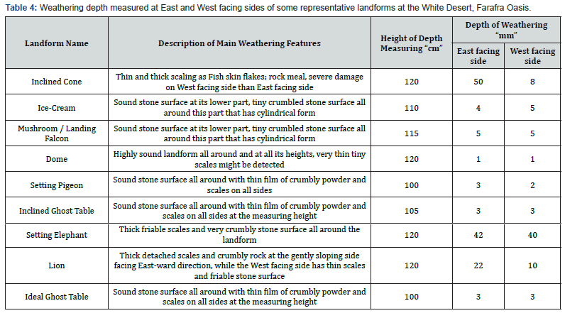
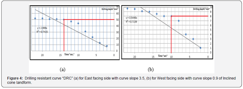
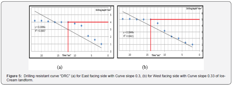
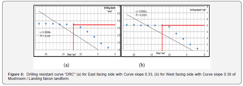
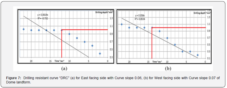
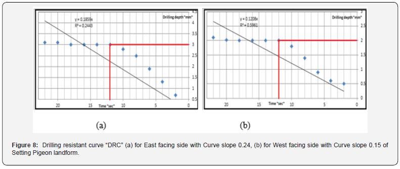
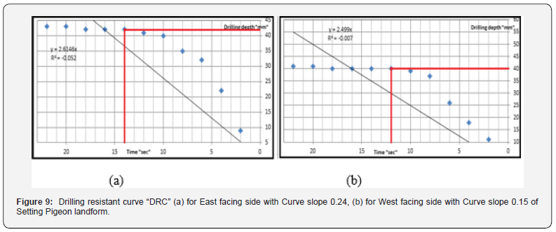
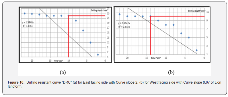
The landforms at the study area are almost oriented east-west direction with top-head tilted to the West direction. The height of these landforms above its surroundings has been recorded and found to be variable from one landform to the other i.e. they are ranging from 0.5m to 7.0m. The stone’s surface of these forms presents weathering to different limits of damage categories varying from one side to the other for the same form on one hand, and from one form to the other on the other hand. Not only that but also from the lower to the upper part of the same landform as indicated in the above section (Figure 2a & 2h). Consequently, the weathering depth and profile have been tested in the current study for some selected and representative landforms using a drilling device system “DDS” and the data has been listed in (Table 4) for the former and graphically represented (Figure 4 -11) for the latter.

Slope angle of the landforms’ sides
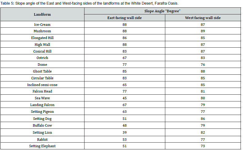
The landforms at the study area present either nearly equalsides’ slope-angle e.g. Ice-Cream, Mushroom, Elongated hill, High wall, Dome, Ghost Circular table; or un-equal-sides’ slope-angle of other forms that their East-facing side has gentle slope compared with their West-facing side. The measurements conducted for these landforms’ sides are listed in (Table 5). This difference in sides’ slope angle will be discussed, in the current study, in conjunction with the environmental parameters (e.g. solar heating and solar heating duration, windblown with sand …. etc.).
Laboratory results
Petrography and purity in composition
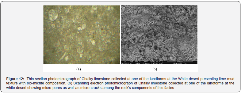
Rock’s petrography had been previously reported to be one of the parameters controlling rock’s durability to weathering processes [17,18]. Consequently, it has been examined in the current study using thin sections surveyed under a transmitting polarizing microscope and the scanning electron microscope for some representative rock samples collected at the symmetric and the as-symmetric landforms. Representative photomicrographs for these facies are shown in (Figure 12a & 12b). It is clear that the rocks of these landforms have bio-micrite composition [19] with lime-mud texture [20] having micro-pores of un-equal size (Figure 12a). This pore system (that had been recently reported to be the main culprit behind rock’s susceptibility to weathering, Yu & Oguchi [13] will be accurately measured in the current study using the Mercury Intrusion Porosimetry “MIP-5900”. The SEM clarified that the rock has micro-spars, narrow connected microcracks (Figure 12b).
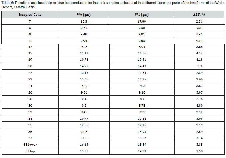
To check out the purity of the rock composing the landforms under investigation, acid insoluble residue (A.I.R.) test had been conducted using diluted hydrochloric acid following the methods of Bruce [21] and Barry [22]. The results are listed in (Table 6) indicating that the rock is highly pure carbonate rock with impurities ranging from 1.9% to 5.0% [21].
Rock’s pore size distribution and its WSI
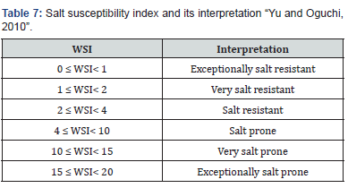
The rock’s total porosity is not directly controlling rock’s weathering susceptibility, but the rock’s pore size distribution (PSD) is the main culprit behind its weathering susceptibility [13]. Consequently, some rock samples that represent the weathered as well as reference samples have been examined using MIP-5900, the results are listed in (Table 7). The weathering susceptibility index (WSI) has been computed using the MIP results for these samples, then, its interpretation has been achieved for each sample using the Yu & Oguchi [13] classification and interpretation (Table 7). The MIP results preciously define the PSD that control the rock’s WSI using the broad-scale classification of Yu and Oguchi (2010) and the detailed classification of Steiger & Asmussen [23], the data are listed in (Table 7).
\
Acid durability test
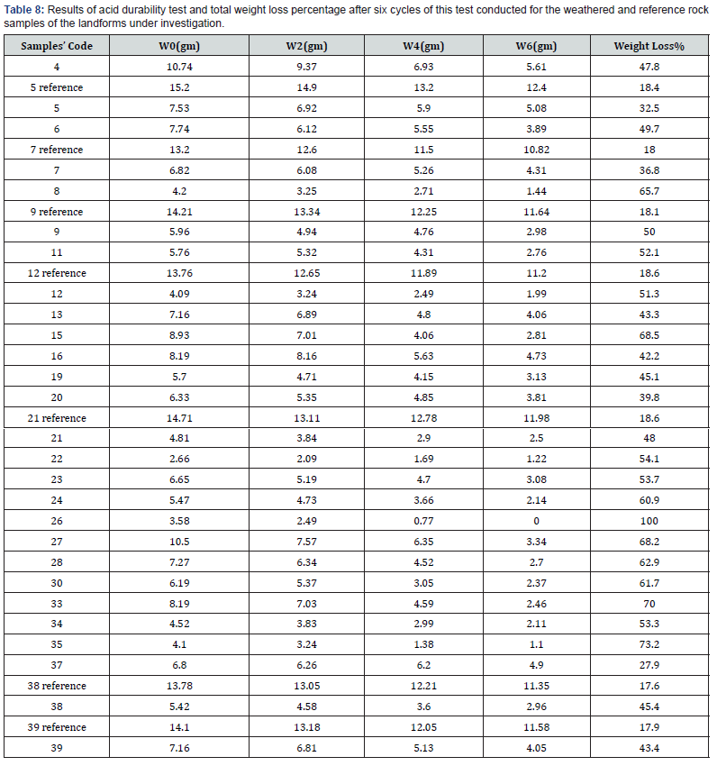
As the rock composing these landforms indicated (from the petrographic and purity test) high similarity in texture and composition, consequently, its durability from one side to the other (for the same landform) as well as from one landform to the other is expected to be very similar. More investigation regarding this durability (using diluted HCl) had been conducted for rock samples collected at the East and West facing sides (that presents variable weathering intensities) for the same landform as well as for different landforms. Not only that but also for some selected reference (control) samples at both sides of the same landform or different landforms have been examined. The results are listed in (Table 8) indicating high similarity or equality in total weight loss percentage for the reference samples (around 18%) at the different sides of the same or different landforms at the study area. But this is not the case for the weathered samples either of the same landform or different landforms with higher weight loss for those collected at the east facing side compared with those of the west facing side.
Hydrochemical analysis
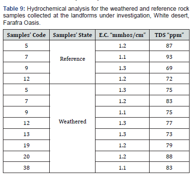
It has been conducted for four reference samples and eight samples collected at the weathered parts of the different landforms, the results are listed in (Table 9). It has been indicated that the reference and weathered samples have a very low salt content that reaches up to 93ppm. As the extracted solution’s salt content “TDS” controls its electrical conductivity [15] so, this conductivity had been measured for the extracted solutions of these samples. It has been clarified that these samples have very low electrical conductivity (that reaches up to 1.3mmhos/cm) in their extracted solutions (Table 9).
Sand size distribution
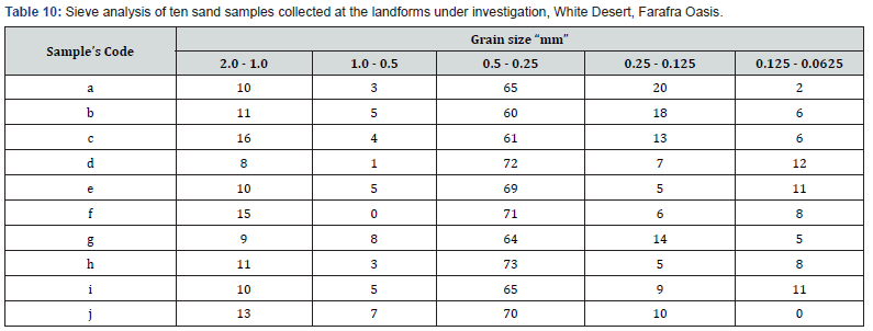
As ripples of sand circulate around most of the landforms under investigation, then, ten sand samples had been collected to find out their grain size distribution. Sieve analysis using set of sieves with variable mesh size had been used, the results are listed in (Table 10). This sort of analysis might throw light on the possibility of sand abrasion and creation of the landforms noted at this hot dry study area. 6- Discussion
The landforms at the study area are variable in their morphology consequently named based on their general view e.g. Mushroom forms; animal forms as Rabbit, Elephant, Pigeon; Sea waves forms. They can also be grouped based on their symmetry into symmetric and as-symmetric landforms. Fortunately, the maturity stages and progress of these landforms particularly the Mushroom is recorded at this broad area of investigation i.e. mushroom developing from the rock mass with major head loaded on broad neck (Figure 2c); on weathering progress particularly at the lower part of this rock mass, the neck is altered to cylindrical form loading head above forming an Ideal Mushroom (Figure 2d). But if this weathering is progressed on the neck of this Mushroom, then, the head rock mass falls down leaving a high wall behind (Figure 2e) with some vertical fractures created probably as a result of tectonics or hitting this long neck by the Mushroom head during its fall down. Some other landforms e.g. setting pigeon, setting dog, Ghost table, Rabbit (e.g. Figure 2f-2h) clearly represent differential weathering that creates, almost by wind-blown with sand that prevails at this area as well as other weathering processes, these forms. The inclined landforms e.g. setting dog, inclined cone, are highly expected to be a result of differential solar heating (intensity and duration) from the east-facing side that receives longer and higher dose of solar heating than the west-facing side. This resulted in multiple scaling, intersected cracks, and powdering of this east-facing side compared with west-facing side. The west-facing side is always fresh rock, uncovered with weathering products, due to its polishing with windblown with sand. The variation in weathering on this texturally
and mineralogically homogenous rock confirm the impact of the environmental parameters, e.g. solar heating and duration, direction and intensity of wind-blown with sand, on this rock creating many geometries and geo-heritages as noted at the study area. The weathering products e.g. scaling and rock fragmentation particularly on a gentle slope, i.e. the east-facing, side protect the underneath rock mass from further weathering and creates a micro-environment among the gaps of these fragments and flakes enabling moisture accumulation within these gaps particularly at this hot climate area (Pye and Mottershead [24]; Moussa et al. [25]. Measuring weathering depth and its profile on the east-facing side and west facing side of some landforms using DDS confirm higher weathering depth associated with profile almost characterized by rapid penetration of the drill pen of the DDS for some millimeters then slower penetration on reaching this drill pen the fresh main rock mass compared with clear west-facing side (Table 4), (Figure 4-11). This difference in weathering depth and profile is negligible on all sides of the vertically erected landforms e.g. Mushrooms, Ice Cream and Landing Falcon landforms due to homogenous weathering intensity all around (Figure 2b, 2d & 2f).
The physical weathering is not only restricted to the lower parts of these landforms but also extends to their upper parts that reaches up to 7m or more above its surroundings. This is well represented by detachment of rock masses and fragmenting the rock that rests on the top-most part of this landform. This is not restricted to the inclined landforms but also for the vertically seated ones (Figure 2b & 2d). Windblown with medium size sand is not the main culprit behind weathering at these topmost parts, but the daily heating-cooling cycles at such desert with severe climatic conditions over the geologic time scale has been recorded to be the main factor acting process [26]. Each of rock’s texture, composition including purity, and the negligible salt content that reaches to zero salt content (compared with rock’s TDS at urban and rural areas reaching up to 279000ppm, [27] are not participating in rock’s weathering at the white desert (Table 6 & 9). This has been proved through the laboratory investigations regarding these parameters indicating high similarity in rock’s texture and composition on one hand, and no effective salt content in that rock at the study area.
Continuing with the physical properties of the weathered and reference “control” rock composing the landforms under investigation considering PSD and WSI, it has been noted that the reference samples (of the different landforms) present high similarity in their PSD as well as WSI (Table 7). But this PSD has been noted to vary on rock’s weathering, as noted for the collected weathered rock samples, to higher ranges/limits of WSI (Table 7). For more clarification, the reference rock becomes salt prone (particularly for the west facing side or the neck of the vertically seated landforms e.g. samples code 5, 12, 23, 38 and 39, (Table 7) and very salt prone (particularly for the east facing side and top-most parts of these landforms e.g. samples code 8, 13 and 24, (Table 7). This indicates that PSD is one of the main rock’s physical parameters that control its susceptibility to weathering by the prevailing processes at the study area.
Almost the landforms under investigation have higher damage category at their top-most parts compared with their lower parts (Figs. 2a, b and d) with exception of some cases where damage category is equal (Figure 2e & 2g) or reversed (Figure 2h). The former case is due to longer diurnal solar heating followed by cooling at night time i.e. almost the top-most part of the landforms is exposed to about half day heating and half day cooling at limits of severity of climatic conditions as that listed in (Table 2). While the latter case is for the short landforms where weathering equally acts on the whole rock mass (e.g. Figure 2g). Using the DDS to find out the maximum penetration depth of weathering as well as the weathering profile from one side to the other of the investigated landforms (Figure 4-11), it has been noted that the weathering creates scales and karsts of variable or uniform thicknesses that is numerically detected and graphically plotted on binary relation between weathering depth versus time. This graphical relationship indicates that weathering intensity varies through geologic time scale and this is represented through the weathering profile that might be steady with time progress or unsteady rate of penetration by the DDS. This regime of weathering profile controls slope value even if the two sides of a given landform or of two different landforms have the same weathering penetration depth (e.g. Figure 6a & 6b); (Figure 7a &7b); (Figure 11a & 11b) or have the same time of stability (the time at which penetration of DDS stops, e.g. (Figure 6a & 6b, 8a & 8b). For the inclined landforms (e.g. Inclined cone, Lion), the east facing side presents more weathering expressed by greater weathering depth than the west facing side of the same landform (Table 4). While the vertically structured landforms e.g. Ice-Cream, Mushroom, Landing Falcon, Ideal Ghost Table, Dome (Figure 5a & 5b);(Figure 6a & 6b); (Figure 7a & 7b); (Figure 11a & 11b), the weathering depth is the same on east and west facing sides of each of these landforms (Table 4). The main reason behind this variation in weathering depth and profile is expected to be a result of rock’s response to variation in intensity and regime of weathering processes [2,18,24] in particular heating-cooling cycles daily and seasonally, from East to West facing sides of the inclined landforms. It is also worthless to mention that the altitude (that had been measured for the landforms under investigation using the GPS and recoded to be ranging from 15m to 51m above sea level) has no direct or inverse proportional relation with the damage categories defined for the landforms under investigation.
Conclusion
The current research has been conducted in detail on the rock’s composition and morphological classification as well as its durability against weathering processes creating the landforms at the widely spread area known as the White Desert. The rock at the white desert is homogenous in texture and composition, almost chalk, and is classified as weathering resistant one for the control rock mass, while the weathered parts facing the west direction are classified as weathering prone rock and those facing the east direction are very weathering prone rock. The rock’s pore size distribution has proved to be one of the main factors controlling rock’s susceptibility to weathering. The wind-blown with medium-size sand, solar heating duration are the most effective physical weathering processes, from one direction to the other on the same landform, at the study area and result in creation of symmetric and as-symmetric landforms with equal or un-equal damage categories at the lower and upper parts of these forms. Salt weathering and rock mass altitude are not recorded to be one of the weathering processes or factors acting on these landforms.
Future Research
Preservation of these geologic Heritage can be conducted based on this study through fixing of the sand source reaching these landforms, increasing rock’s durability to weathering by using a suitable resins at a tested concentration, fixing of these cracks using anchor screws or using a suitable consolidating material (resins) wherever it is suitable. All these suggestions must be tested and examined in detailed in a further research to keep this area well presented for tourism and sitting it on a suitable web site for world-world announcement on Desert Tourism or eco-tourism at such unique geologic heritage area.
Acknowledgment
The authors are greatly thankful for the Central labs of Menoufiya Univ., Egypt and that of Saitama University, Japan for conducting the laboratory work of this research. Also, the authors highly appreciate the efforts of Dr. Derek Alex for English editing of the manuscript of this paper.
References
- Beadnell HJL (2002) Farafra Oasis, its topography and geology. Geological Survey. Egypt, Cairo, p. 39.
- Embabi NS (2004) The Geomorphology of Egypt, the Nile Valley and the Western Desert. The Egyptian Geological Society, Cairo, Egypt, p. 447.
- Hermina M (1990) The surroundings of Kharga, Dakhla & Farafra oases. In: Said R (Eds.), The Geology of Egypt. Egyptian General Petroleum Corporation, pp. 259-292.
- Omara S, Hemida I, Sanad S (1970) Structure and hydrogeology of Farafra Oasis, Western Desert, UAR. In: 7th Arab Petroleum Congress, Kuwait, p. 65.
- Issawi B, Francis M, Youssef A, Osman R (2009) The Phanerozoic of Egypt: A geodynamic approach. Geological Survey of Egypt, Cairo, p. 589.
- Ekaterina E, Emad S, Sallam M, Dmitry A Ruban A (2016) Geological heritage of the Bahariya and Farafra oases, the central Western Desert of Egypt. African Earth Sciences 116(10): 151-159.
- Said R (1962) The geology of Egypt. Elsevier, Amsterdam, p. 377.
- Thabet WA (2017) Categorization and mapping of natural landforms at Farafra Oasis and its surroundings, un-published MSc Thesis, Menoufiya University, Egypt.
- Orabi OH, Zaky AS (2016) Differential dissolution susceptibility of Paleocene foraminiferal assemblage from Farafra Oasis, Egypt. Journal of African Earth Sciences 113: 181-193.
- Pickford M, Wanas H, Mein P, Ségalen L, Soliman H (2010) The extent of paleokarst and fluvio-lacustrine features in the Western Desert, Egypt; Late Miocene subaerial and subterranean paleohydrology of the Bahariya-Farafra area. The Tethys Geological Society, Cairo, Egypt 5: 35- 42.
- Gray M (2008) Geodiversity: developing the paradigm. Proceedings of the Geologists Association 119(3-4): 287-298.
- Gray M (2013) Geodiversity. Valuing and Conserving Abiotic Nature. Wiley-Blackwell, Chichester, p. 495.
- Yu S, Oguchi CT (2010) Role of pore size distribution in salt uptake, damage, and predicting salt susceptibility of eight types of Japanese building stones. Engineering Geology 115(3-4): 226-236.
- Jefferson DP (1993) Building stone: the geological dimensions. Quarterly Journal of Engineering Geology 26: 305-319.
- Rhoades JD (1982) Soluble salts, methods of soil analysis, Part 2: Chemical and microbiological properties. (2nd edn), Agronomy Monograph No. 9.
- Fitzner B, Heinrichs K (2002) Damage diagnosis on stone monuments- weathering forms, damage categories and damage indices. Understanding and Managing stone decay. In: Prikryl, Viles (Eds.), The Karolinum Press, Prague, Czechia.
- Benavente D, Cura G, Fort MA, Ordonez S (2004) Role of pore structure in salt crystallization in unsaturated porous stone. Journal of Crystal Growth 260(3-4): 532-544.
- Moses C, Williams R (2008) Weathering and durability of the Goldsworthy Chalk Stones, South Downs, West Sussex, England. Env Geology 56: 495-506.
- Folk RL (1962) Spectral subdivision of limestone types, classification of carbonate rocks. Symposium of American Association of the Petroleum geologists 1: 62-84.
- Dunham RJ (1962) Classification of carbonate rocks according to depositional, texture. In: WE Ham (Ed.), Classification of carbonate rocks. Mem Am Petrol Geol Tulsa, pp. 108-121.
- Bruce FM (1974) A rapid and accurate method for the analysis of calcium carbonate in small samples. Journal of Sedimentary Petrology 44(2): 589-590.
- Barry AR (1991) The durability of porous stone. Stone Industries 26(10): 22-25.
- Steiger M, Asmussen S, (2008) Crystallization of sodium sulfate phases in porous materials: the phase diagram Na2SO4-H2O and the generation of stress. Geochimica Acta 72(17): 4291-4306.
- Pye K, Mottershead DN (1995) Honeycomb weathering of Carboniferous sandstone in a sea wall at Weston-super-Mare, UK. Quarterly Journal of Engineering Geology 28: 333-347.
- Moussa S, Haykel S, Ammar M (2018) Climate change impact projections at the catchment scale in Tunisia using the multi-model ensemble mean approach. Arabian Journal of Geosciences 11: 181-191.
- Salman AB, Howari FM, El-Sankary MM, Wali AM, Saleh MM (2010) Environmental impact and natural hazards on Kharga Oasis monumental sites, Western Desert of Egypt. Journal of African Earth Sciences 58(2): 341-353.
- Kamh GME (2009) Quantification and modeling of damage category of weathering forms of monumental rocks based on field measurements. Restoration of Buildings and Monuments. An Int Journal 15(1): 21-38.
- Ordonez S, Fort R, del Cura G (1997) Pore size distribution and the durability of a porous limestone. Quarterly Journal of Engineering Geology 30: 221-230.


