Evaluating and Ranking the Threats in the Indian Mangrove Forest Adjacent to Bangladesh Sundarbans
Arpita Saha*1, Tanmay Ray Chaudhuri1, Sufia Zaman1, Prosenjit Pramanick1, Abhishek Saha1 and Abhijit Mitra2
1Department of Oceanography, Techno India University, India
2Department of Marine Science, University of Calcutta, India
Submission: May 02, 2017; Published: May 30, 2017
*Corresponding author: Arpita Saha, Department of Oceanography, Techno India University, West Bengal, Salt Lake, Sector V, Kolkata 700091, India, Email: arpitasaha890@gmail.com
How to cite this article: Arpita Saha*, Tanmay Ray Chaudhuri, Sufia Zaman, Prosenjit Pramanick, Abhishek Saha and Abhijit Mitra Evaluating and Ranking the Threats in the Indian Mangrove Forest Adjacent to Bangladesh Sundarbans. Organic & Medicinal Chem I J. 2017; 2(4): 555595.DOI: 10.19080/OMCIJ.2017.02.555595
Abstract
Mangrove ecosystems are exposed to a variety of threats. These threats encompass stressors like deforestation, over exploitation of mangroves, pollution, sea level rise, siltation etc. In this paper, we have captured the major threats operating on the mangrove ecosystem of Indian Sundarbans, which is mostly under the reserve forest and lies adjacent to the western part of the Bangladesh Sundarbans. We selected five categories of respondents to evaluate and rank the major threats by the product of Threat Ranking (TR) and % of voting of the respondents to achieve the total Threat Score (TS) and finally the Combined Threat Scale (CTS) for each category of threat. Our analysis revealed highest CTS (Combined Threat Scale) value to erosion and lowest to pollution, which may be attributed to high wave actions and minimum anthropogenic pressure in the eastern Indian Mangrove forest adjacent to Bangladesh Sundarbans
Abbreviations: Indian mangrove forest; respondents; Threat Score (TS); Combined Threat Scale (CTS).
Introduction

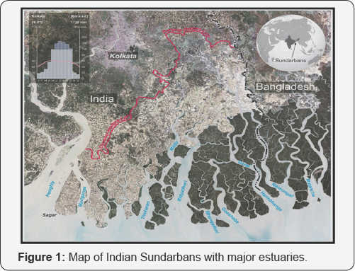
The Indian Sundarbans lies at the apex ofthe Bay of Bengal and include the areas boarding the Hooghly, Muriganga, Saptamukhi, Thakuran, Gosaba, Vidya, Matla and Harinbhanga estuaries, known as the Hooghly- Matla estuarine complex (Figure 1). The mangrove forests of the Indian Sundarbans have been variously estimated at 418,888 hectares [1,2], 200,000- 300,000 hectares [3], and at 426,300 hectares by the Forest Department of West Bengal. It has further been estimated that approximately 178,000 hectares are water areas. The discrepancy in the figures for forest cover possibly arises from the fact that some denote areas designated as forest land (i.e., including waterways and degraded forest) while others represent an assessment of the tree covered areas only [4-7]. The eastern sector of Indian Sundarbans falls mostly under the reserve forest.
The growth of mangroves is very luxuriant in this forest as there is minimum anthropogenic pressure in this sector. However, the fringe villages with substantial population need timber, fuel wood, fodder grass, honey, wax, fishes, crabs etc for their livelihood. Hence, the villagers encroaches the reserve forest illegally to get these resources. This causes a negative pressure on the positive health of the mangrove ecosystem. In addition to this, stressors like natural disaster, siltation, pollution, sea level rise etc also cause a negative impact on the mangrove ecosystem. Considering this background, we conducted an opinion poll from respondents who are direct and indirect stakeholders related to Sundarban mangroves. Our basic aim was to address a series of critical questions to the respondents for capturing the major threats operating in the reserve forest area of Indian Sundarbans, and threre by pinpoint the most important threat on which management action plan should give proper weight age in terms of conservation and budget allocation.
Materials and Methods
The entire network of the present study consist of three stages
i) identification of respondents (policy maker, researcher, fisherman, agriculturist and local inhabitants)
ii) identification of major threats (6 in number) and
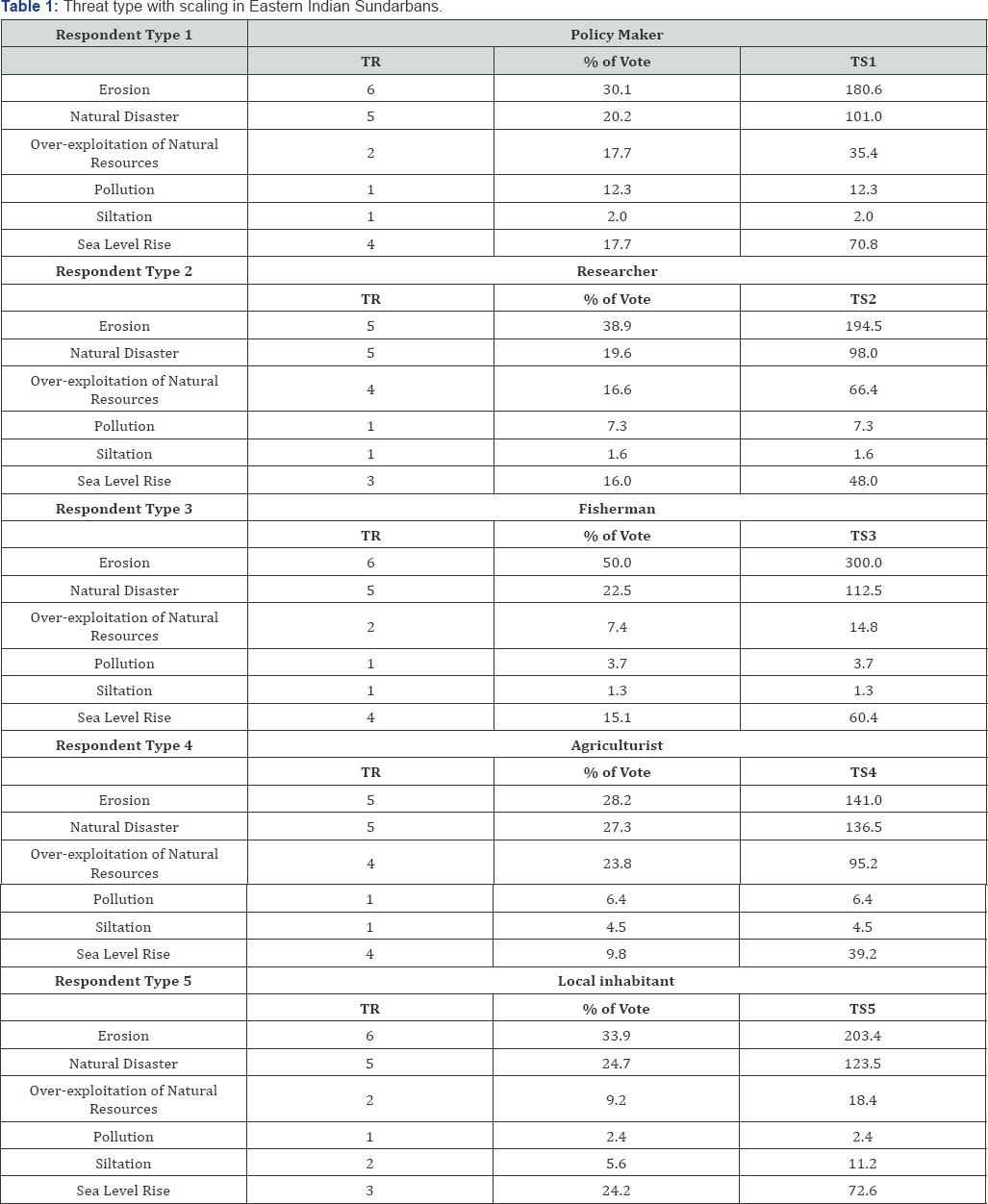
iii) evaluation of the respondent's response to construct the threats scale through ranking and voting. Although threats can be of various types, our list captures the major threats operating on the eastern sector of the mangrove ecosystem of Indian Sundarbans. Threats were ranked in terms of their importance by building a Threat Assessment Matrix (TAM). However, as there is high probability of variation of this ranking with the category of respondents, therefore the views of the respondents were also considered (by inclusion of the % of voting along with their respective ranking factor) and finally Combined Threat Scale (CTS) was constructed on the basis of Threat Scale (TS) computed as per the expression: CTS = TS1 + TS2 + TS3 + TS4 + TS5, Where, TS = Threat Rank (TR) x % of Vote
Results
The respondent analysis conducted on the threats operating on eastern sector of Indian Sundarbans assigned highest value to erosion (1019.5), followed by natural disaster (571.5), sea level rise (291.0), over exploitation of natural resources (230.2), pollution (32.1) and siltation (20.6) (Table 1).

Discussion
Assessment of threat and standardization of proper technique of threats assessment is very important to evaluate the magnitude of stress operating on a particular ecosystem. Our results provide important guidance on the type of threat operating on the mangrove forest in the eastern sector of Indian Sundarbans. Our survey method is not an exercise in management or conservation priority setting because different groups (respondents) have different goals, rather it is a composite effort to capture the views of major categories of respondents who are the key players in regulating the ecosystem services of mangrove ecosystem in the selected study area. In our study, we observe the highest CTS value is assigned to erosion (1019.5). This is in accordance with the ground reality as confirmed by the satellite imagery. Natural disaster is the second highest threat as opined by the respondents with a CTS value of 571.5. The present geographical locale is prone to cyclone, which generates high tidal surges and wave actions [8,9]. The present region also experiences sea level rise, which is much higher (3.14 mm/ yr) compared to the global average. This may be the effect of tidal bulging and subsidence of the deltaic floor
All these factors have imparted considerable weight age to natural disaster. This region of Indian Sundarban is basically protected as Reserve Forest (RF) and hence the natural resources are plenty in terms of availability. This has resulted the fringe villagers to penetrate inside the forest illegally for procuring mangrove-originated products with a CTS value of 230.2. Over exploitation of natural resources has also become a threat in the reserve forest area of Indian Sundarbans although policy maker, fisherman and local inhabitants have assigned a low value of 2 to this threat. This may be due to direct involvement of these three categories of respondents in regulating the natural resource budget in the RF area. The policy makers controlling the law and order within the protected areas, are directly responsible for policy implementation for conservation, and hence from their perspective assigning low score to exploitation of natural resources are natural. The fisherman and local inhabitants, on the other hand, is the people who illegally enter the reserve forest area to procure timber, fuel wood, honey, wax, fishes and crabs and hence they tried to mask their illegal activities by assigning low score to over exploitation of natural resources. Pollution and siltation are observed to receive low CTS values mainly due to absence of industries and anthropogenic activities around this zone.
The entire study reveals that measures against erosion and natural disaster should be given highest priority for conservation the natural resources in this sector of Indian Sundarbans. Despite the challenges associated with management of vulnerable ecosystems, our results suggest the potential for positive change by emphasizing the need to develop technology to control erosion, which may be the plantation of mangroves on Geo-Jute covered embankment encircling the erosional sites.
References
- Sidhu S S (1963) Studies on the mangroves of India: East Godavari Region. Indian Forester 89(5): 337-351.
- United Nations Environment Programme (UNEP) (1985) Environmental problems of the marine and coastal area of India: National Report.
- International Union of Conservation and Nature (IUCN) (1993) Marine Protected Areas Needs in the South Asian Seas Regions. 2 India. Switzerland.
- Chaudhuri A B, Choudhury A (1994) Mangroves of the Sundarbans. Volume 1: India. International Union for Conservation of Nature and Natural Resources (IUCN). Switzerland.
- Mitra A (2013) In: Sensitivity of Mangrove ecosystem to changing Climate. Springer .
- Mitra A, Zaman S (2015) Blue Carbon Reservoir of the Blue Planet. Earth Sciences & Geography.
- Mitra A, Zaman S (2016) Basics of Marine and Estuarine Ecology. Environmental Sciences.
- Mitra A, Pal N, Chakraborty A, Mitra A, Trivedi S, et al. (2016a) Estimation of stored carbon in Sonneratia apetala seedlings collected from Indian Sundarbans. Indian Journal of Marine Science 45(11): 1598-1602.
- Mitra A, Jana H K, Ray Chaudhuri T (2016b) In: Ecological Health of Indian Sundarbans and Its Management. Published by Narendra Publishing House.


