




 OAJELS Home



Abstract
Geospatial technologies are increasingly transforming education by enabling learners to visualize spatial relationships, analyze environmental information, and engage with complex real-world problems. Their integration with sustainability and engineering education provides opportunities to develop spatial thinking and environmentally informed decision-making. Despite growing evidence of the educational benefits of GIS, remote sensing, Google Earth, and related technologies, existing research remains fragmented across spatial thinking, environmental literacy, sustainability education, and climate-resilient engineering. This study aims to synthesize existing evidence and examine the pathway from geospatial visualization and spatial thinking to environmental understanding, sustainability competencies, and climate-resilient engineering decision-making. The study proposes an integrated educational perspective connecting geospatial literacy with environmental, climate, and engineering competencies rather than examining these outcomes independently. A structured literature-based synthesis was undertaken covering research on GIS, remote sensing, spatial thinking, geospatial literacy, environmental literacy, climate literacy, sustainability education, and technology-enabled resilience planning. The synthesis demonstrates that geospatial technologies strengthen spatial reasoning, visualization, critical thinking, environmental understanding, systems thinking, and problem-solving. Their effectiveness is enhanced through inquiry-, project-, problem-, and STEM-based learning. Integration with AI, machine learning, remote sensing, and climate modelling further supports predictive and scenario-based decision-making.
Keywords: Geospatial Technologies, Spatial Thinking, Sustainability Education, Climate Literacy, Resilient Engineering.
Highlights
· Geospatial learning strengthens spatial and sustainability competencies.
· GIS connects environmental understanding with engineering decision-making.
· AI-enabled geospatial education supports climate-resilient planning.
Introduction
Geospatial technologies have become increasingly important in contemporary education because they provide powerful mechanisms for representing, analyzing, and interpreting spatial information across environmental, geographical, architectural, and engineering contexts. Geographic Information Systems (GIS), remote sensing, virtual globes, and other geospatial platforms enable learners to move beyond conventional two-dimensional representations by integrating maps, imagery, environmental datasets, and spatial relationships within interactive learning environments [1]. The educational application of GIS has been associated with improvements in spatial reasoning, map interpretation, visualization, and problem-solving, allowing students to investigate authentic geographical phenomena through evidence-based approaches [2]. Spatial thinking is particularly important because it involves the ability to use spatial concepts, representations, and reasoning processes to understand relationships between objects, locations, patterns, and processes [3]. Research has further demonstrated that exposure to GIS-based learning can produce measurable improvements in students’ spatial thinking abilities, including their capacity to interpret spatial information and formulate solutions to geographical problems [4]. The use of Google Earth and other three-dimensional geospatial environments has similarly supported spatial visualization, mental rotation, and learning achievement among students [5]. These developments indicate that geospatial technologies are not merely technical instruments for map production but increasingly function as cognitive learning environments that support higher-order thinking. Their integration into education therefore provides an opportunity to strengthen spatial literacy while simultaneously connecting theoretical knowledge with real-world environmental and spatial problems.
The educational significance of geospatial technologies extends beyond spatial competence because contemporary environmental challenges require learners to understand complex interactions between human activities, ecological systems, climate processes, and built environments. Sustainability education increasingly emphasizes systems thinking, critical thinking, problem-solving, futures thinking, and the ability to translate knowledge into informed action [6]. Geospatial learning can contribute to these competencies by allowing students to visualize environmental change, investigate spatial patterns, analyze relationships between human and natural systems, and evaluate alternative responses to sustainability challenges [7]. Empirical studies have reported that integrating geospatial technologies into sustainability education can improve students’ strategic thinking, perceived sustainability competencies, engagement, and interest in sustainability-related learning [8]. GIS-supported environmental education has also demonstrated potential for strengthening interdisciplinary learning by connecting spatial information with social, environmental, and sustainability dimensions of contemporary problems [9]. Similarly, project-based, problem-based, inquiry-based, and STEM-oriented approaches have been identified as effective pedagogical strategies for developing spatial thinking when combined with geospatial technologies [10]. Climate literacy represents another important dimension because understanding climate processes and their consequences requires learners to interpret spatial and temporal information and recognize relationships between environmental conditions and human vulnerability [11]. The growing integration of remote sensing, GIS, artificial intelligence, and big-data analytics further enables learners to investigate climate risks using increasingly sophisticated datasets and analytical approaches [12]. Consequently, geospatial education can provide an important bridge between spatial literacy, environmental literacy, climate literacy, and sustainability-oriented competencies. This integration is particularly relevant for engineering and architectural education, where future professionals must increasingly incorporate environmental risks, resource constraints, and climate considerations into planning and design decisions.
The transition from geospatial learning toward sustainable engineering competency is particularly significant in the context of accelerating urbanization, climate change, environmental degradation, and increasing infrastructure vulnerability. Conventional educational approaches often separate technical knowledge from environmental and spatial decision-making, limiting students’ opportunities to understand how engineering interventions interact with complex geographical systems. Geospatial technologies provide an alternative by integrating spatial datasets, environmental observations, infrastructure information, and analytical models within a common decision-support environment [13]. GIS-based learning has been shown to strengthen critical thinking and geographic problem-solving by requiring students to formulate questions, analyses evidence, interpret spatial relationships, and develop alternative solutions [14]. The incorporation of geospatial technologies into climate-resilience education can further expose learners to flood susceptibility, heat stress, land-use change, environmental vulnerability, and other spatially differentiated risks [15]. Recent developments in GeoAI demonstrate the potential to combine artificial intelligence with spatial information for predictive environmental analysis, climate-risk assessment, infrastructure planning, and resource management [16]. Remote sensing and machine-learning approaches similarly provide opportunities to analyze climate vulnerability and built-environment characteristics, particularly in regions where conventional datasets are limited [17]. These developments suggest a progressive competency pathway in which geospatial visualization develops spatial reasoning, spatial reasoning strengthens environmental understanding, and environmental understanding supports evidence-based spatial decision-making. For engineering students, this pathway can ultimately contribute to more sustainable, adaptive, and climate-resilient infrastructure planning and design [18]. Nevertheless, the literature remains fragmented across geography education, environmental education, sustainability education, and engineering applications, with comparatively limited synthesis of how these domains can be connected through geospatial learning. Addressing this fragmentation is essential for establishing a coherent educational framework capable of linking spatial intelligence with sustainability and climate-resilient engineering practice.
Against this background, the present study addresses the problem of fragmented integration between geospatial education, spatial thinking, environmental literacy, sustainability competencies, and climate-resilient engineering decision-making. Although existing studies provide substantial evidence regarding the educational benefits of GIS and related technologies, much of the literature examines individual outcomes such as spatial thinking, critical thinking, environmental awareness, or technological proficiency rather than examining their progression as interconnected competencies. The aim of this study is therefore to synthesize the existing evidence and establish a conceptual pathway from geospatial visualization and spatial literacy toward environmental understanding, sustainability competencies, and climate-resilient engineering decision-making. The novelty of the study lies in bringing these previously dispersed educational dimensions together within an integrated geospatial learning perspective that connects cognitive spatial development with environmental and engineering applications. Methodologically, the study adopts a structured literature-based synthesis of research addressing GIS, remote sensing, Google Earth, spatial thinking, geospatial literacy, environmental literacy, climate literacy, sustainability education, and technology-enabled climate-resilient planning, with evidence interpreted comparatively across educational and applied contexts. The synthesis examines recurring educational outcomes, technological approaches, pedagogical strategies, implementation challenges, and emerging opportunities to identify relationships between geospatial learning and sustainability-oriented competencies. The findings demonstrate that geospatial technologies can support a progression from visualization and spatial reasoning to environmental interpretation, systems thinking, problem-solving, and evidence-based decision-making. The analysis further indicates that project-based, inquiry-based, problem-based, and STEM-oriented pedagogies strengthen the educational effectiveness of geospatial technologies by connecting digital spatial analysis with authentic environmental and societal challenges. It also highlights the growing potential of integrating GIS with remote sensing, artificial intelligence, machine learning, big-data analytics, and climate modelling to support predictive and scenario-based learning. Overall, the study establishes geospatial education as a potential foundation for developing spatially literate, environmentally informed, sustainability-oriented, and climate-resilient professionals capable of addressing complex twenty-first-century engineering challenges.
Geospatial Technologies for Environmental, Earth-System and Civil Engineering Education
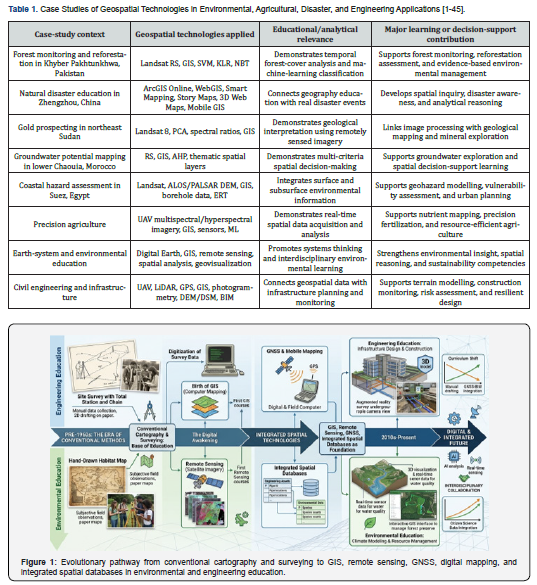
Geospatial technologies have evolved from conventional cartographic and surveying practices into integrated digital systems that support environmental, Earth-system, and engineering education through spatial visualization, analysis, modelling, and decision-making. Traditional maps and field surveying initially provided the fundamental spatial framework for representing landscapes, infrastructure, natural resources, and environmental processes, but their largely static nature limited the analysis of rapidly changing geographic phenomena [1]. The development of Geographic Information Systems (GIS) introduced computational capabilities for storing, organizing, manipulating, and visualizing geographically referenced information, transforming spatial data from static representations into analytical resources [2]. Remote sensing subsequently expanded this capability by enabling students and researchers to observe land, water, vegetation, geological features, and atmospheric processes across multiple spatial and temporal scales [3]. The integration of Global Navigation Satellite Systems (GNSS) further strengthened geospatial education by enabling accurate positioning, field-data collection, navigation, and integration of ground observations with digital spatial datasets [4]. Digital mapping and spatial databases subsequently enabled the organization of heterogeneous environmental and engineering information within interoperable digital environments, supporting more systematic spatial analysis [5]. The emergence of WebGIS transformed this environment by providing browser-based access to spatial data, interactive maps, dashboards, story maps, and analytical services without requiring extensive specialized software infrastructure [6]. These developments have progressively shifted geospatial education from map interpretation toward inquiry-based, analytical, and technology-supported learning in which students investigate real-world spatial problems. Overall, the evolution of geospatial technologies demonstrates how spatial information has progressively changed from a representation of geographic reality into an interactive educational environment for understanding complex Earth and engineering systems.
The case studies summarized in Table 1 demonstrate that geospatial technologies have become applicable across a broad continuum of environmental and engineering problems rather than remaining confined to conventional geography education. Forest monitoring studies demonstrate how multitemporal satellite imagery and machine-learning classifiers can be used to investigate changes in vegetation and evaluate reforestation interventions [7]. WebGIS-based disaster education demonstrates how real-world events can be transformed into interactive inquiry activities through smart maps, story maps, three-dimensional visualization, and mobile GIS [8]. Remote sensing and GIS applications in geological exploration similarly demonstrate how image enhancement, spectral analysis, and spatial mapping can connect Earth-science concepts with practical resource assessment [9]. Groundwater studies using GIS-based analytical hierarchy processes illustrate how multiple environmental variables can be integrated to construct spatial decision-support models [10]. Coastal vulnerability research further demonstrates the educational value of combining satellite observations, digital elevation data, borehole information, and geophysical measurements to understand multidimensional environmental hazards [11]. UAV-based precision agriculture provides another example in which students can connect high-resolution image acquisition, sensor data, GIS visualization, machine learning, and resource optimization within a single applied workflow [12]. Such examples demonstrate that geospatial learning can move beyond theoretical instruction toward authentic problem-solving in which students collect, integrate, analyze, visualize, and interpret spatial evidence. Therefore, the case studies collectively indicate that geospatial technologies provide a practical bridge between conceptual Earth-system knowledge and evidence-based engineering and environmental decision-making.
From Conventional Mapping to GIS and Remote Sensing
The transition from conventional mapping and surveying to GIS and remote sensing represents the foundational technological transformation underlying contemporary geospatial education. Early geographic instruction relied predominantly on paper maps, topographic sheets, compass-based surveying, and manually prepared thematic representations through which students developed basic spatial orientation and cartographic interpretation skills (Figure 1). The emergence of digital GIS introduced a fundamentally different approach by allowing geographically referenced information to be stored as structured spatial databases and analyzed through computational operations [13]. Digital GIS environments enabled learners to overlay multiple thematic layers, identify spatial relationships, perform proximity analysis, and examine changes across geographic space and time [14]. Remote sensing expanded this analytical framework by providing repeated observations of Earth's surface through satellite-based sensors capable of recording information across different spectral regions [15]. Landsat and other Earth-observation programmes subsequently enabled environmental education to incorporate long-term observations of vegetation, land-use change, water bodies, urban expansion, and ecosystem transformation [16]. GNSS technologies complemented remote sensing by allowing students to collect accurately positioned field observations and connect physical measurements with remotely sensed and GIS-based datasets [17]. Digital elevation models, digital surface models, and spatial databases further enabled students to interpret terrain morphology, drainage systems, landscape structure, and infrastructure relationships within three-dimensional and multidimensional environments [18]. The resulting workflow transformed mapping from a predominantly descriptive activity into a process involving data acquisition, spatial analysis, interpretation, validation, and visualization. This progression established the technological foundation upon which contemporary geospatial and Earth-system education continues to develop.
The educational significance of this technological transition lies in its capacity to develop spatial reasoning while simultaneously strengthening students' understanding of dynamic environmental and engineering processes. GIS-based learning allows students to compare historical and contemporary datasets, identify spatial patterns, and interpret relationships between environmental variables that may remain difficult to recognize through conventional maps alone [19]. Remote sensing provides opportunities for students to investigate environmental change through multitemporal imagery, including deforestation, urban expansion, agricultural transformation, water-resource changes, and landscape degradation [20]. Spatial databases further encourage students to integrate heterogeneous information such as satellite imagery, field measurements, administrative boundaries, geological data, infrastructure layers, and socioeconomic indicators into a common analytical framework [21]. The development of digital cartography and interactive visualization also improves communication because students can transform complex spatial datasets into maps, animations, models, and other forms of geovisual representation [22]. Research on spatial-skills education indicates that mapping, modelling, sketching, and computer-based spatial activities can contribute to the development of spatial reasoning required for STEM learning [23]. The incorporation of these technologies into geography and Earth science therefore changes students' roles from passive recipients of mapped information to active investigators of spatial phenomena [24]. This approach also supports field-to-digital learning cycles in which observations collected in physical environments are subsequently analyzed and interpreted within digital spatial platforms. The overall learning gained from this transition is that GIS and remote sensing transform conventional cartographic knowledge into an analytical and inquiry-oriented foundation for modern geospatial education.
Emerging Geospatial and AI Technologies
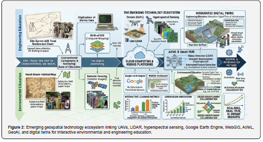
Emerging geospatial technologies are extending conventional GIS and remote sensing toward highly interactive, automated, three-dimensional, and artificial-intelligence-supported learning environments (Figure 2). UAVs provide educators with a flexible means of acquiring high-resolution aerial imagery and generating detailed orthomosaics, point clouds, and three-dimensional surface models for localized investigations [25]. LiDAR technologies complement optical imagery by providing highly detailed three-dimensional information that can be used to characterize terrain, vegetation structure, buildings, and infrastructure [26]. Hyperspectral imaging further expands environmental analysis by recording numerous narrow spectral bands that can support detailed discrimination of minerals, vegetation conditions, soil properties, and other surface characteristics [27]. Cloud-based platforms such as Google Earth Engine provide access to extensive archives of remotely sensed datasets and computational resources, enabling students to conduct large-scale environmental analyses without maintaining extensive local computing infrastructure [28]. WebGIS platforms similarly facilitate browser-based access to spatial databases, interactive dashboards, story maps, three-dimensional maps, and collaborative geospatial applications [29]. Artificial intelligence and machine-learning methods have introduced automated classification, prediction, object detection, pattern recognition, and spatial modelling capabilities into geospatial workflows [30]. Deep learning can further process complex satellite, UAV, LiDAR, and multimodal datasets to identify environmental patterns that may be difficult to detect through conventional analytical approaches [31]. Digital twins and virtual-real integration provide an additional frontier by connecting physical environments with dynamic digital representations that can be explored, monitored, and modelled in near real time [32]. These technologies collectively create opportunities for moving geospatial education toward immersive, data-rich, and computationally enabled learning environments.
The educational value of emerging technologies is particularly evident in their ability to transform students from users of prepared spatial datasets into participants in complete geospatial data workflows. UAV-based laboratory exercises can introduce students to mission planning, image acquisition, photogrammetric processing, spatial interpretation, and environmental assessment within practical STEM activities [33]. WebGIS enables collaborative learning because spatial information can be accessed through web browsers and incorporated into interactive maps, dashboards, and narrative-based educational resources [34]. Cloud-based geospatial platforms also enable students to analyses extensive time-series datasets, making it possible to investigate environmental processes at regional and global scales [35]. AI and GeoAI introduce computational thinking by requiring learners to understand training data, model selection, classification, validation, prediction, and interpretation of algorithmic outputs [36]. The integration of augmented reality with GeoAI can further support immersive learning by placing spatial information within three-dimensional and contextual environments that allow students to investigate Earth processes interactively [37]. Digital Earth concepts similarly connect physical and virtual environments through geovisualization, remote sensing, spatial modelling, and spatial analysis, strengthening interdisciplinary understanding of complex Earth systems [38]. These technologies also support personalized and inquiry-based learning by enabling students to manipulate datasets, test hypotheses, compare scenarios, and evaluate alternative spatial outcomes. The principal lesson from these developments is that emerging geospatial and AI technologies can convert environmental and engineering education into interactive, computational, and evidence-driven learning experiences.
Geospatial Technologies in Interdisciplinary Engineering Education
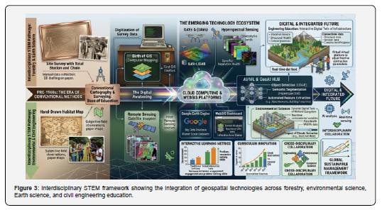
The integration of geospatial technologies into interdisciplinary STEM education has expanded their educational relevance across forestry, environmental science, Earth science, and civil engineering (Figure 3). In forestry education, remote sensing, LiDAR, UAVs, and AI can be combined to examine forest structure, biomass, species distribution, canopy characteristics, land-cover dynamics, and carbon-related indicators [39]. Environmental science education can similarly use GIS and remote sensing to investigate ecosystem degradation, water resources, pollution, climate impacts, biodiversity, and land-use change through spatially explicit datasets [40]. Earth science education benefits from geospatial approaches because geological mapping, geomorphological interpretation, groundwater assessment, mineral exploration, and hazard analysis require the integration of remotely sensed observations with terrain and field information [41]. In civil engineering, UAV photogrammetry, LiDAR, GNSS, GIS, digital elevation models, and building information modelling provide opportunities to connect spatial analysis with infrastructure planning, construction monitoring, terrain assessment, and risk management [42]. Such integration enables students from different disciplines to work with common spatial datasets while addressing discipline-specific questions and constraints. STEM-based geography research indicates that geospatial technologies can support research activities, practical skills, analytical reasoning, interdisciplinary connections, and project-based learning [43]. Drone-based educational programmes similarly demonstrate that geospatial technologies can stimulate cognitive, psychomotor, and affective learning through practical and collaborative activities [44]. The resulting educational environment encourages students to approach environmental and engineering challenges as interconnected systems rather than isolated disciplinary problems. This interdisciplinary orientation demonstrates that geospatial technologies can function as a common technological language linking environmental sciences, Earth sciences, forestry, geography, and engineering education.
The strongest educational contribution of interdisciplinary geospatial learning is its capacity to connect spatial thinking with authentic environmental and engineering problem-solving. Forest monitoring activities can require students to combine ecological knowledge with remote sensing classification, GIS analysis, machine learning, and field validation to interpret ecosystem dynamics [45]. Environmental projects can similarly require students to integrate climatic, hydrological, biological, socioeconomic, and spatial information when investigating sustainability challenges. Earth-science investigations can connect geological processes with satellite imagery, terrain models, field observations, and spatial decision-support methods, thereby strengthening systems-oriented reasoning. Civil-engineering applications can integrate surveying, UAV mapping, LiDAR, GIS, BIM, and AI to examine infrastructure conditions, construction progress, terrain characteristics, and environmental risks. Such activities correspond closely with contemporary STEM approaches in which students learn through investigation, experimentation, data analysis, modelling, and problem-solving rather than through isolated theoretical instruction. The integration of geospatial technologies also encourages communication between disciplines because spatial datasets provide a common framework through which environmental scientists, geographers, engineers, foresters, and data scientists can exchange information. Project-based geospatial activities can consequently strengthen spatial literacy, computational thinking, data interpretation, collaboration, and evidence-based decision-making simultaneously. The broader learning from this interdisciplinary model is that geospatial technologies provide an integrative educational framework capable of connecting Earth-system understanding with practical environmental management and sustainable engineering.
From Geospatial Visualization to Spatial Thinking and Sustainable Engineering Competencies
Geospatial visualization is increasingly transforming education from conventional information delivery toward spatially enabled analytical learning that connects geographic evidence with environmental and engineering problems. Geographic Information Systems (GIS), remote sensing, virtual globes, web-based mapping platforms, and cloud-based geospatial environments allow learners to transform geographically referenced datasets into interactive representations through which spatial distributions, relationships, patterns, and temporal changes can be examined. [46] These technologies provide students with opportunities to interpret complex urban, environmental, and infrastructural systems through multiple spatial scales and perspectives. [47] GIS-supported education has been associated with improvements in spatial thinking, problem-solving, visualization, and analytical reasoning when students actively manipulate and interpret spatial information. [48] Interactive platforms such as ArcGIS Online and StoryMaps further enable learners to connect environmental problems with geographic locations and social conditions, strengthening engagement with sustainability-related issues. [49] Geospatial learning has also demonstrated potential for developing planning-oriented sustainability competencies, including strategies-thinking and students perceived capacity to address sustainability challenges. [50] The integration of GIS with project-based and problem-based learning encourages learners to investigate authentic problems and construct evidence-based interpretations rather than relying exclusively on predefined theoretical information. [51] Such approaches promote interdisciplinary learning by linking geography with environmental science, engineering, architecture, urban planning, economics, and sustainability studies. [52] The educational significance of this integration is particularly relevant to engineering because spatially informed learners must evaluate site characteristics, environmental constraints, hazard distributions, infrastructure relationships, and alternative development scenarios. [53] Table 2 summarizes representative applications of geospatial technologies and demonstrates their contribution to spatial cognition, sustainability awareness, analytical reasoning, and decision-oriented competencies. The key learning is that geospatial visualization functions most effectively as an educational bridge between spatial information, analytical reasoning, and sustainable engineering competence.
The progression from visualization toward sustainable engineering competence depends on the ability of learners to transform spatial representations into interpretable knowledge and subsequently into defensible decisions. Spatial technologies allow students to compare locations, identify environmental patterns, examine relationships among geographic variables, and evaluate the consequences of alternative interventions within realistic contexts. [54] Research on GIS-based interventions demonstrates that exposure to spatial technologies can improve students’ spatial reasoning and their ability to interpret geographically structured information. [55] Google Earth and similar three-dimensional visualization environments provide additional opportunities for examining spatial relationships through changes in perspective, scale, orientation, and representation. [56] QGIS-supported Spatial-Based Learning has further demonstrated improvements in problem formulation, argumentation, inference, alternative generation, and decision-making, indicating that geospatial education can extend beyond technical mapping toward higher-order cognition. [57] Google Earth Engine similarly expands learning into computational geospatial analysis by enabling students to examine large Earth-observation datasets and investigate environmental processes across space and time. [58] The combination of these technologies with inquiry-based learning allows students to develop transferable competencies relevant to environmental assessment, urban planning, infrastructure development, and climate-risk analysis. [59] However, the literature emphasizes that technological availability alone does not guarantee meaningful learning because effective outcomes depend on pedagogical design, assessment strategies, instructor competence, and opportunities for authentic spatial inquiry. [60] Consequently, geospatial education should be structured as a progressive pathway in which visualization supports interpretation, interpretation supports reasoning, and reasoning supports evidence-based decision-making. The principal lesson is that the educational value of GIS and related technologies is realized when spatial visualization becomes a foundation for higher-order reasoning and sustainable engineering practice.
Development of Spatial Thinking and Geospatial Literacy
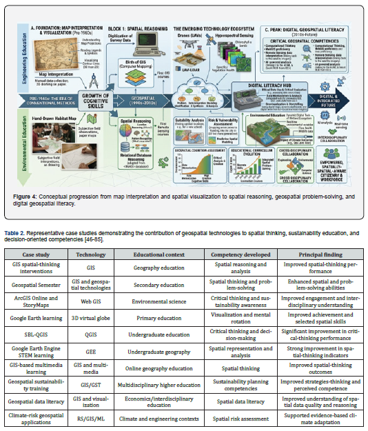
The development of spatial thinking represents a fundamental educational pathway through which learners progress from basic map interpretation toward advanced spatial reasoning and geospatial problem-solving. Spatial thinking involves the coordinated use of spatial concepts, representation tools, and reasoning processes to understand locations, distances, directions, distributions, relationships, and patterns. [61] GIS provides an interactive environment where these concepts can be explored through thematic layers, spatial queries, overlays, buffers, and multidimensional geographic datasets. [62] Empirical investigations using spatial-thinking assessments have reported significant improvements following exposure to GIS concepts and software, demonstrating that geospatial instruction can strengthen spatial reasoning capabilities. [63] Google Earth and other virtual-globe environments further support visualization by allowing learners to manipulate three-dimensional representations and examine geographic phenomena from different perspectives and scales. [64] Project-based and problem-based learning can amplify these benefits by requiring students to apply spatial concepts to authentic environmental and societal problems. [65] Research using QGIS-based Spatial-Based Learning has demonstrated improvements in formulating problems, providing arguments, drawing conclusions, proposing alternatives, and making decisions. [66] Google Earth Engine extends this progression by introducing learners to computational analysis of large Earth-observation datasets and spatial-temporal environmental information. [67] Geospatial literacy consequently requires more than operating GIS software because learners must also evaluate data sources, recognize uncertainty, interpret spatial representations, and critically assess the reliability of geographic information. [68] Figure 4 illustrates this progression from visualization and map interpretation toward spatial reasoning, geospatial literacy, and digital spatial problem-solving. The principal learning is that spatial thinking should be developed as a transferable cognitive competency rather than treated merely as a technical GIS skill.
Advanced spatial thinking develops when learners integrate multiple spatial variables and use geographic evidence to construct explanations and solutions to complex problems. GIS enables students to overlay environmental, demographic, topographic, infrastructural, and land-use datasets within a common spatial framework, thereby facilitating comparison and relationship-based reasoning. [69] Studies of GIS-based interventions indicate that students can improve their ability to recognize spatial relationships and apply geographic evidence when instruction incorporates inquiry, interpretation, and problem-solving activities. [70] The Geospatial Semester provides an additional example of sustained geospatial learning in which students investigate authentic problems using geospatial technologies and develop spatial skills through extended practical engagement. [71] Spatial competencies developed through these environments are relevant beyond geography because visualization, spatial relations, mental rotation, and three-dimensional reasoning are important within engineering, architecture, environmental planning, and other STEM disciplines. [72] Geospatial technologies therefore provide a practical mechanism for developing digital spatial skills that can subsequently be applied to site assessment, infrastructure planning, environmental monitoring, and hazard analysis. [73] Research on spatial-thinking assessment nevertheless indicates that the construct is multidimensional and difficult to measure comprehensively because different instruments capture different combinations of visualization, representation, reasoning, and problem-solving. [74] Effective geospatial curricula should therefore incorporate explicit spatial-thinking objectives, repeated analytical exercises, authentic datasets, and assessment strategies aligned with specific spatial competencies. [75] Such curriculum design can progressively transform students from passive consumers of maps into active interpreters and producers of spatial information. Figure 4 consequently represents geospatial literacy as an iterative process in which visualization, interpretation, reasoning, and application reinforce one another. The key learning is that sophisticated spatial literacy emerges when learners repeatedly apply geospatial representations to authentic analytical and decision-making problems.
Environmental Literacy, Climate Literacy and Sustainability Competencies
Geospatial learning provides a direct educational connection between spatial thinking and environmental literacy by allowing students to interpret ecological and environmental processes through geographically explicit evidence. Environmental literacy requires learners to understand environmental systems, recognize human–environment interactions, evaluate environmental problems, and develop capacities for responsible action. [76] GIS and related geospatial technologies support these competencies by representing land-use change, vegetation dynamics, environmental degradation, resource distribution, climatic variability, and human impacts within spatially interpretable frameworks. [77] ArcGIS Online and StoryMaps have demonstrated the ability to connect sustainability concepts with real-world locations and social conditions, thereby increasing engagement and critical understanding of complex environmental issues. [78] Geospatial sustainability training has also produced improvements in strategies-thinking and perceived competence across planning-oriented sustainability competencies. [79] These findings correspond with broader Education for Sustainable Development approaches that emphasize systems-thinking, futures-thinking, values-thinking, and action-oriented learning. [80] Climate literacy can be strengthened when students use spatial datasets to investigate temperature variation, flood exposure, vegetation conditions, drought, land-cover change, and other climate-related indicators. [81] Such spatial investigations allow learners to connect local environmental observations with broader Earth-system processes and recognize the interactions among hazards, exposure, vulnerability, and human activity. [82] Figure 5 conceptualizes this educational relationship by positioning geospatial visualization as an intermediary between environmental observation, Earth-system understanding, climate literacy, and sustainability competence. The principal learning is that geospatial education can transform environmental awareness into deeper climate and sustainability competencies when spatial evidence is connected with systems thinking and action-oriented learning.
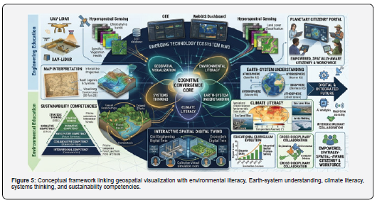
The progression from environmental literacy to sustainability competence requires students to understand not only where environmental problems occur but also how their causes, consequences, and potential solutions interact across spatial and temporal scales. Geospatial technologies enable learners to examine environmental phenomena simultaneously across locations, periods, and levels of analysis, thereby supporting systems-oriented interpretation. [83] Problem-Based Learning and Project-Based Learning become particularly effective when combined with GIS, Google Earth, ArcGIS, and related tools because students investigate authentic sustainability challenges rather than learning environmental concepts in isolation. [84] Spatial learning also facilitates interdisciplinary analysis by integrating environmental, social, economic, and infrastructural variables within a shared geographic framework. [85] This interdisciplinary capacity is particularly relevant to sustainable engineering because infrastructure systems interact continuously with ecosystems, resources, communities, hazards, and socioeconomic conditions. [86] Climate-oriented geospatial learning can therefore incorporate investigations of flood susceptibility, urban heat, water scarcity, ecosystem degradation, disaster exposure, and infrastructure vulnerability. [87] Students can additionally develop futures-thinking by comparing current environmental conditions with projected scenarios and examining how alternative interventions may modify future spatial outcomes. [88] Climate education research indicates that knowledge can influence climate concern, self-efficacy, and willingness to engage in climate-protective behavior, although improved literacy does not necessarily produce consistent behavioral change. [89] Accordingly, sustainability-oriented geospatial curricula should integrate knowledge development with values, critical reflection, scenario analysis, collaborative problem-solving, and action competencies. Figure 5 consequently illustrates a progression from spatial observation toward environmental interpretation, climate understanding, systems thinking, and sustainability-oriented action. The key learning is that environmental and climate literacy becomes more meaningful when geospatial knowledge enables learners to understand interconnected systems and evaluate sustainable responses.
From Geospatial Learning to Climate-Resilient Engineering Decision-Making
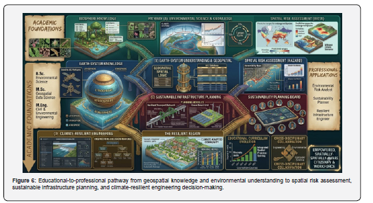
Geospatial learning ultimately gains professional significance when spatial knowledge is transformed into evidence-based decision-making for climate-resilient engineering and infrastructure development. Climate-resilient planning requires simultaneous consideration of hazard exposure, environmental sensitivity, socioeconomic vulnerability, land-use dynamics, infrastructure characteristics, and projected climatic conditions. [90] Remote sensing and GIS provide spatially explicit information through which heat-stress zones, flood-prone areas, impervious surfaces, vegetation deficits, elevation-related hazards, and vulnerable infrastructure can be identified. [91] The integration of machine learning and GeoAI can further transform heterogeneous spatial datasets into predictive vulnerability surfaces and risk classifications that support targeted adaptation planning. [78] Big-data decision-support systems can integrate satellite observations, Internet of Things data, meteorological information, and social datasets to improve climate-risk forecasting and spatial prioritization of resources. [79] Scenario-based geospatial modelling enables planners and engineers to evaluate infrastructure alternatives under different climatic and socioeconomic futures rather than relying exclusively on historical environmental conditions. [80] These capabilities can support the spatial prioritization of drainage networks, green-blue infrastructure, transportation corridors, flood protection, heat mitigation, and other adaptation interventions. [81] Research in the construction sector additionally indicates substantial potential for remote sensing and digital technologies in climate-resilient construction, although standardization, data integration, institutional capacity, and implementation barriers remain important constraints. [82] Figure 6 therefore establishes a conceptual pathway in which geospatial knowledge develops environmental understanding, environmental understanding supports spatial-risk interpretation, and spatial-risk interpretation informs sustainable engineering decisions. The principal learning is that climate-resilient engineering education must progress from software proficiency toward spatial risk interpretation and evidence-based infrastructure decision-making.
The final stage of this competency pathway involves integrating spatial evidence with engineering judgement, sustainability principles, and climate-adaptation objectives to support context-specific infrastructure decisions. Geospatial datasets can assist engineering students in evaluating alternative sites, identifying hazard-sensitive locations, assessing environmental constraints, and determining the spatial suitability of proposed infrastructure interventions. [83] When combined with remote sensing, GIS, machine learning, and scenario modelling, these capabilities allow learners to evaluate multiple dimensions of infrastructure resilience rather than treating climate hazards as isolated technical problems. [84] Spatial decision-support environments can facilitate multi-criteria evaluation by integrating physical, ecological, social, economic, and infrastructural indicators within a unified analytical framework. [85] This approach is particularly important in urban environments where flooding, heat stress, land-use change, population growth, and infrastructure expansion interact across space and time. [86] GeoAI-based approaches can further identify high-risk locations and evaluate nature-based solutions, zoning strategies, and infrastructure modifications under alternative climate scenarios. [87] Digital twins, predictive analytics, and optimization approaches can extend this process toward dynamic infrastructure management and adaptive planning under changing environmental conditions. [88] Responsible engineering education must nevertheless address data quality, algorithmic uncertainty, model interpretability, accessibility, ethical considerations, and biases within geospatial datasets and automated analytical systems. [89] A mature geospatial engineering curriculum should therefore combine technical GIS competence with critical data literacy, interdisciplinary collaboration, sustainability reasoning, and explicit climate-risk assessment. The overall lesson is that geospatial education achieves its greatest value when students can progress from visualizing spatial information to interpreting environmental risks and designing defensible, sustainable, and climate-resilient engineering responses.
Discussions and Future Recommendations
The integration of geospatial technologies into education represents a transition from conventional content-based instruction toward spatially informed, interdisciplinary, and sustainability-oriented learning. GIS, remote sensing, Google Earth, virtual globes, and web-based mapping platforms provide learners with opportunities to interpret spatial relationships, visualize environmental processes, and connect theoretical knowledge with real-world conditions [46]. Experimental evidence indicates that GIS-based learning can improve spatial reasoning, critical thinking, geographic skills, and students’ ability to interpret spatial information [51]. Studies using QGIS and spatial-based learning approaches have further demonstrated significant improvements in students’ abilities to formulate problems, construct arguments, evaluate alternatives, and make spatial decisions [57]. Google Earth and other three-dimensional geospatial environments have similarly been associated with improvements in achievement and selected spatial abilities, particularly mental rotation and spatial interpretation [63]. The educational effectiveness of these technologies is enhanced when they are combined with inquiry-based, problem-based, project-based, and STEM-oriented pedagogies rather than being treated solely as technical software [54]. Such approaches allow students to progress from identifying spatial patterns toward interpreting relationships and developing evidence-based solutions to complex geographical and environmental problems [60]. Geospatial learning also provides an effective foundation for interdisciplinary education because spatial datasets can simultaneously represent environmental, social, infrastructural, and economic dimensions of a problem [47]. This capability is particularly important for engineering and architectural education, where spatial relationships influence site selection, environmental assessment, infrastructure planning, and risk management [53]. The evidence therefore indicates that geospatial technologies should be understood as cognitive and analytical learning environments capable of developing spatially competent and sustainability-oriented professionals. Future educational frameworks should consequently integrate geospatial technologies with authentic problem-solving activities to strengthen the connection between spatial knowledge and professional decision-making.
The reviewed literature further indicates that geospatial education can contribute to environmental literacy, climate literacy, and broader sustainability competencies when spatial technologies are embedded within contextual environmental problems. Geospatial learning enables students to examine land-use change, environmental degradation, climate hazards, resource distribution, and human–environment interactions through spatial evidence [49]. Research on sustainability-focused geospatial education demonstrates improvements in strategies-thinking and students perceived competence across multiple sustainability-related dimensions [55]. GIS-supported environmental science instruction has also been shown to increase student engagement, critical thinking, and interdisciplinary understanding of sustainability challenges [68]. These outcomes are important because environmental and climate literacy requires more than factual knowledge; learners must understand interactions between environmental systems, human activities, risks, and possible responses [72]. Systems-thinking approaches supported through spatial visualization can help students recognize interconnected processes and understand how changes in one component may influence other components across different spatial and temporal scales [76]. Climate education research similarly indicates that knowledge and understanding of climate processes can influence concern, self-efficacy, and willingness to engage in climate-related action [81]. The incorporation of remote sensing, GIS, artificial intelligence, and big-data analytics can further extend this educational pathway by allowing learners to investigate environmental conditions and climate risks using contemporary datasets [84]. GeoAI and spatial modelling additionally provide opportunities for students to move beyond observation toward prediction, scenario development, and evidence-based environmental decision-making [87]. Such technological progression is particularly valuable for engineering education because climate-resilient infrastructure requires professionals capable of interpreting environmental information and translating spatial risks into appropriate design responses [90]. Future curricula should therefore establish stronger connections between geospatial literacy, environmental education, climate science, and sustainability competencies through interdisciplinary projects and real-world datasets. Geospatial learning can function as a pathway through which spatial understanding develops into environmental awareness, systems thinking, and sustainability-oriented action.
Conclusion
Geospatial technologies have emerged as important educational tools for strengthening spatial thinking, geospatial literacy, environmental understanding, and sustainability competencies across diverse educational disciplines. The reviewed literature demonstrates that GIS, remote sensing, Google Earth, QGIS, ArcGIS Online, and other spatial technologies provide learners with opportunities to visualize complex phenomena, interpret spatial relationships, analyses environmental datasets, and develop evidence-based solutions to real-world problems. Their educational value extends beyond technical mapping because geospatial learning encourages spatial reasoning, critical thinking, problem-solving, inquiry, and interdisciplinary collaboration. The evidence further indicates that the effectiveness of geospatial technologies is strongly influenced by pedagogical approaches, with project-based, problem-based, inquiry-based, and STEM-oriented learning providing particularly effective environments for developing higher-order spatial competencies. Integration with environmental and sustainability education additionally enables students to connect spatial observations with broader Earth-system processes, climate risks, resource management, and sustainable development challenges. This progression establishes an important educational pathway from geospatial visualization and spatial reasoning toward environmental literacy, systems thinking, and sustainability-oriented decision-making. For architecture, engineering, geography, environmental science, and related disciplines, such competencies are increasingly important because professional practice requires the interpretation of complex spatial and environmental information. Geospatial education can therefore contribute substantially to preparing students for emerging challenges associated with urbanization, climate change, environmental degradation, and infrastructure vulnerability. Overall, the synthesis confirms that geospatial technologies should be considered strategic educational platforms rather than merely technical tools, particularly when they are integrated with authentic environmental and engineering problems.
The findings further establish that the future potential of geospatial education depends on its ability to connect technological capabilities with meaningful pedagogical transformation and professional application. Emerging integration of GIS with remote sensing, artificial intelligence, machine learning, big-data analytics, digital twins, and climate modelling can expand educational activities from basic visualization toward predictive analysis, scenario development, risk assessment, and climate-resilient decision-making. However, effective implementation requires attention to technological infrastructure, data accessibility, teacher and faculty competencies, curriculum flexibility, interoperability, ethical data use, and inequalities in access to digital learning resources. Future research should therefore employ longitudinal, experimental, and multi-institutional approaches to determine whether improvements in spatial thinking and sustainability competencies are retained over time and transferred into professional practice. Educational institutions should also strengthen interdisciplinary geospatial laboratories, open-data initiatives, cloud-based learning environments, and collaborative projects involving engineering, environmental science, geography, architecture, and planning. Particular emphasis should be placed on developing locally relevant datasets and climate-resilience case studies so that students can apply geospatial knowledge to the environmental and infrastructural challenges of their own communities. The integration of geospatial technologies should consequently be accompanied by assessment frameworks capable of measuring spatial reasoning, environmental literacy, systems thinking, problem-solving, and sustainability decision-making rather than software proficiency alone. Such an approach can ensure that technological adoption produces meaningful educational outcomes rather than simply increasing the digital content of existing curricula. Ultimately, geospatially enabled education provides a foundation for developing professionals who can interpret spatial evidence, understand interconnected environmental systems, evaluate future risks, and formulate sustainable engineering responses.
Acknowledgement
The authors would like to express their sincere gratitude to all individuals and departments who contributed to the successful completion of this research. Special thanks are extended to Al-Mussawir Engineers and Creative Engineering Zone (CEZ) for their technical support and assistance throughout the study. The authors are also highly grateful to S.E. PHED Rawalpindi Syed Hussnain, Public Health Engineering Department Rawalpindi, for his valuable guidance and support.
References
- Kerski JJ (2023) Teaching and learning geography with a Web GIS approach. In Re-visioning Geography: Supporting the SDGs in the post-COVID Era. Cham: Springer International Publishing 113–135.
- Piloyan A, M Petrosyan (2024) Enhancing environmental education through Digital Earth technologies and applications. International Journal of Geoinformatics 20: 29-35.
- Ribeiro T, C Vasconcelos (2025) Earth system science and education: From foundational thoughts to geoethical engagement in the Anthropocene. Geosciences 15: 224.
- Hennig S, J Schaller, T Schötz (2024) Digital geomedia in education for sustainable development. International Journal of Geoinformatics 20: 10-21.
- Li J, H Xia, Y Qin P, Fu, X Guo, R Li, X Zhao (2022) Web GIS for sustainable education: Towards natural disaster education for high school students. Sustainability 14: 2694.
- Ribeiro T, N Orion (2021) Educating for a holistic view of the earth system: A review. Geosciences 11: 485.
- Zhou C (2025) Exploring future GIS visions in the era of the scientific and technological revolution. Information Geography 1: 100007.
- Annoni A, S Nativi, A Çöltekin, C Desha, E Eremchenko, et al. (2023) Digital earth: Yesterday, today, and tomorrow. International Journal of Digital Earth 16: 1022-1072.
- Lü G, J Xiong, M Wu, L Yuan, J Li, M Chen, Z Yu et al. (2025) Geographic information discipline development: Demands, strategy and challenges. Information Geography 1: 100012.
- Koupatsiaris AA, H Drinia (2024) Expanding geoethics: Interrelations with geoenvironmental education and sense of place. Sustainability 16: 1819.
- Duschl RA, KM Bateman, S Maeng, S McDonald (2024) Geology and Earth Systems Sciences Learning Progressions. Handbook of Research on Science Learning Progressions Pp: 233-255.
- Hochschild V, A Braun, C Sommer, G Warth, A Omran (2021) Visualizing landscapes by geospatial techniques. In Modern Approaches to the Visualization of Landscapes. Wiesbaden: Springer Fachmedien Wiesbaden. 47-78.
- Vinueza-Martinez J, M Correa-Peralta, R Ramirez-Anormaliza, O Franco Arias, D. Vera Paredes (2024) Geographic information systems (GISs) based on WebGIS architecture: Bibliometric analysis of the current status and research trends. Sustainability 16: 6439.
- Nawaz M, F Sattar (2024) Utilizing Geo-AI and AR for teaching interdisciplinary courses in Earth Science. In 2024 IEEE Global Engineering Education Conference (EDUCON). 1–5.
- Chen XM (2021) Integration of creative thinking and critical thinking to improve geosciences education. The Geography Teacher 18: 19-23.
- Mohamed, MTA, LS Al-Naimi, TI Mgbeojedo, CC Agoha (2021) Geological mapping and mineral prospectivity using remote sensing and GIS in parts of Hamissana, Northeast Sudan. Journal of Petroleum Exploration and Production 11: 1123–1138.
- Lin L, L Di, C Zhang, L Guo, Y Di (2021) Remote sensing of urban poverty and gentrification. Remote Sensing 13: 4022.
- Pande CB, KN Moharir, SFR Khadri (2021) Assessment of land-use and land-cover changes in Pangari watershed area (MS), India, based on the remote sensing and GIS techniques. Applied Water Science 11: 96.
- Sharma S, JO Beslity, L Rustad, LJ Shelby, PT Manos, P, et al. (2024) Remote sensing and GIS in natural resource management: Comparing tools and emphasizing the importance of in-situ data. Remote Sensing 16: 4161.
- Chen X, H Zhang, CUI Wong (2025) Dynamic monitoring and precision fertilization decision system for agricultural soil nutrients using UAV remote sensing and GIS. Agriculture 15: 1627.
- Abdelouhed F, A Algouti, A Algouti, Y Baiddane, M Ifkirne (2021) Using GIS and remote sensing for the mapping of potential groundwater zones in fractured environments in the CHAOUIA-Morocco area. Remote Sensing Applications: Society and Environment 23: 100571.
- Tariq A, Y Jiango, Q Li, J Gao, L Lu, et al. (2023) Modelling, mapping and monitoring of forest cover changes, using support vector machine, kernel logistic regression and naive bayes tree models with optical remote sensing data. Heliyon 9.
- Youssef YM, KS Gemail, M Sugita, M AlBarqawy, MA Teama, et al. (2021) Natural and anthropogenic coastal environmental hazards: An integrated remote sensing, GIS, and geophysical-based approach. Surveys in Geophysics 42: 1109–1141.
- Rana MMSP, MT Rahman, MF Hassan (2025) Mapping groundwater potential zone by robust machine learning algorithms & remote sensing techniques in agriculture dominated area, Bangladesh. Cleaner Water 3: 100064.
- Darem AA, AA. Alhashmi AM Almadani, AK Alanazi, GA Sutantra (2023) Development of a map for land use and land cover classification of the Northern Border Region using remote sensing and GIS. The Egyptian Journal of Remote Sensing and Space Science 26: 341–350.
- Mandal S, A Yadav, AK Priya, A Karthick (2026) Artificial Intelligence and Geospatial Synergy for Smart Agriculture: Next Generation Farming Future. Archives of Computational Methods in Engineering. 1-29.
- Mohamad AA, U Ujang, S Azri, U Mehmood (2026) Enhancing 3D geospatial modelling through multimodal data and machine learning: A systematic literature review. Spatial Information Research 34: 12.
- Darwish D (2025) Geospatial AI future perspectives. In Recent Trends in Geospatial AI. IGI Global Scientific Publishing Pp: 297-324.
- Ravikumar RN, S Aarthi, S Nadarajan, G Masharipova, Z Mamadiyarov, et al. (2026) Big data and cloud computing for climate-oriented remote sensing. In Deep Learning Applications in Remote Sensing for Climate Change Monitoring. IGI Global Scientific Publishing, 165–196.
- Verma S (2025) Contemporary geospatial technologies for urban planning and infrastructure development. ISPRS Annals of the Photogrammetry, Remote Sensing and Spatial Information Sciences 10: 713-718.
- Gupta M, R Bhatnagar (2025) Harnessing AI in geospatial technology for environmental monitoring and management: Applications of AI for geospatial data processing. In Recent Trends in Geospatial AI 73-102.
- Shwetha A, MH Karthik, N Ramanna, GB Bibang (2025) Emerging trends in remote sensing and geospatial technologies for construction industry: A comprehensive review. ISPRS Annals of the Photogrammetry, Remote Sensing and Spatial Information Sciences 10: 643–656.
- Rana R, P Bhambri (2025) The role of IoT in shaping the future of geospatial AI. In Recent Trends in Geospatial AI. IGI Global Scientific Publishing. 177–216.
- Yadav M, MK Verma (2026) Examining the role of geospatial data and AI in conducting comprehensive forestry inventories and mapping to support sustainable forest management. In Advanced Geospatial Intelligence and AI for Environmental Resilience and Sustainable Development, 215–235. Cham: Springer Nature Switzerland.
- Bhambri P (2024) Shaping the future of geospatial AI. Recent Trends in Geospatial AI 177.
- Seminar Y, S Laiskhanov, Y Issakov, T Gajić (2026) A systematic review of geographical education of students through STEM. In Frontiers in Education, 11:1737076. Frontiers Media SA.
- Mufahir A, B Waluya, AJ Astari (2026) Geo-STEM integration and environmental literacy in geography education: A systematic review and bibliometric analysis. Edunesia: Jurnal Ilmiah Pendidikan 7: 496–516.
- Laiskhanov S, Y Seminar (2026) Identifying opportunities for integrating STEM and GeoAI technologies into geographic education. In Frontiers in Education 11:1774264. Frontiers Media SA.
- Laiskhanov S, Y Seminar, Z Nurmagambetuly (2026) Integration of STEM technologies in geography education. Indonesian Journal of Geography 58 (2026): 1.
- Derevyanchuk O, N Ridei N. Tytova, V Ravlyuk, O Yatsko (2025) Implementation of the STEM project ‘Modeling of spatial images of stellated polyhedra’ in the professional training of future vocational education teachers. Edelweiss Applied Science and Technology 9: 84-100.
- Bolick MM, EA Mikhailova, CJ Post (2022) Teaching innovation in STEM education using an unmanned aerial vehicle (UAV). Education Sciences 12: 224.
- Mills H, C Robson, A Linighan, S Edwards, C Larkin (2026) Geospatial UK higher education-status, challenges, and outreach initiatives. The International Archives of the Photogrammetry, Remote Sensing and Spatial Information Sciences 49: 41-48.
- McLaughlin JA, JM Bailey (2023) Students need more practice with spatial thinking in geoscience education: A systematic review of the literature. Studies in Science Education 59: 147-204.
- Yeung RCY, D Sun, CH Yeung (2025) Integrating drone technology in STEM education: Curriculum, pedagogy and learning outcomes. Education and Information Technologies 30: 14237-14272.
- Contente J, C Galvão (2022) STEM education and problem-solving in space science: A case study with CanSat. Education Sciences 12: 251.
- Beriguete Alcántara FE, A De Los Santos Melo, JS Santos Castillos (2024) Geospatial insights: Harnessing GIS for innovation in architectural and building engineering education. In Teaching Innovation in Architecture and Building Engineering: Challenges of the 21st Century, 257–273. Cham: Springer Nature Switzerland
- Joshi I, H Ge, T Zhu, Y He, SM Toh (2026) Impact of geospatial training on key planning sustainability competencies. Sustainable Futures 11: 101934.
- Kolvoord RA (2021) Fostering spatial thinking skills for future citizens to support sustainable development. Cultures of Science 4: 17–24.
- Kerski JJ (2024) Integrating web mapping and geospatial technologies. In Thriving in an Academic Career. Routledge.
- Lase AR, NN Mawaddah, R Rahmadi, J Juwari (2026) Developing spatial thinking competence and sustainability awareness through geography learning: A systematic literature review. Abjadia: International Journal of Education 11: 737–750.
- Ahmad M (2024) Exploring the potential of spatial data for enhancing higher education learners' learning outcomes. In Design and Implementation of Higher Education Learners' Learning Outcomes (HELLO). IGI Global Scientific Publishing Pp: 128–145.
- Malone DJ, JB Firestone, JA Morrison, SN Newcomer, LK Lightner (2024) The whole world in your hands: Explorations in sustainability education using geospatial tools. Science Activities 61 (2024): 180-193.
- Jaeger AJ (2024) Google Earth as a tool for supporting geospatial thinking. Land 13: 2218.
- Handoyo B, P Purwanto, S Ridha, GI Tan (2024) Effect of the spatial based learning using Quantum Geographic Information System on students' critical thinking skills. Journal of Social Studies Education Research 15: 328–379.
- Duarte L, AC Teodoro, H Gonçalves (2022) Evaluation of spatial thinking ability based on exposure to Geographical Information Systems (GIS) concepts in the context of higher education. ISPRS International Journal of Geo-Information 11: 417.
- Haris H, A Mannan, NI Rasjusti (2025) Improving spatial thinking skills through GEE-integrated STEM learning: A quasi-experimental study among geography undergraduates. Information Technology Education Journal Pp:507-518.
- Hickman J (2023) Spatial thinking and GIS: Developing and accessing student competencies. International Research in Geographical and Environmental Education 32: 140–158.
- Lakin JM, J Wai P, Olszewski-Kubilius, S Corwith, D Rothschild, DH Uttal (2024) Spatial thinking across the curriculum: Fruitfully combining research and practice. Gifted Child Today 47: 170–177.
- Horvat M, M Kuzma-Kachur (2025) Development of spatial thinking in the process of cultivating cartographic literacy in primary education learners.
- Saputro BD, AK Putra, L Rahayu (2023) Geographical inquiry with geospatial virtual panoramic: Can improve the spatial skills of geography students? Edueksos: Jurnal Pendidikan Sosial & Ekonomi 12.
- Silaban H, NF Istiawati, NM Wijaya, D Miswar (2026) The influence of geospatial technology-based learning media on students’ spatial thinking ability. Journal Learning Geography 7: 44–56.
- Koc T, FB Topu (2022) Using three-dimensional geospatial technology in primary school: Students’ achievements, spatial thinking skills, cognitive load levels, experiences and teachers’ opinions. Education and Information Technologies 27: 4925-4954.
- Bednarz SW, I Jo, E Shin (2022) Spatial thinking in primary geography.” In Teaching Primary Geography: Setting the Foundation. Cham: Springer International Publishing 133-144.
- Juergens C, AP Redecker (2023) Basic geo-spatial data literacy education for economic applications. KN-Journal of Cartography and Geographic Information 73: 147–159.
- Hidayati N, H Edial (2026) Improving geographical skills through geospatial technology-based tools among high school students. Jurnal Penelitian Pendidikan IPA 12: 237–243.
- Nurjanah N, A Sya, O Hotimah, S Samadi, L Herlina (2025) Condition of spatial literacy and students' spatial thinking ability in mastering the use of maps at state senior high school. Scaffolding: Jurnal Pendidikan Islam dan Multikulturalisme 7 (2025): 131–148.
- Lee J, I Jo (2022) Assessing spatial skills/thinking in geography. In Assessment in Geographical Education: An International Perspective. Cham: Springer International Publishing. P: 77–97.
- Azzahra R, C Muryani, GA Tjahjono (2023) Development of GIS-based learning multimedia to improve spatial thinking ability of social students in high school. GeoEco 9: 242–255.
- Purwanto P, S Utaya, B Handoyo, S Bachri, D Yulistiya, et al (2021) The spatial thinking ability students on the character of urban and rural environments in solving population problems. Review of International Geographical Education Online 11.
- Lee J (2024) Geographical thinking versus spatial thinking. In Handbook of Geography Education. Cham: Springer Nature Switzerland. Pp: 109–129.
- Ridha S, S Utaya, S Bachri, B Handoyo, PA Kamil, et al. (2021) Spatial thinking and decision-making abilities to learn about disaster preparedness. IOP Conference Series: Earth and Environmental Science 630: 012017.
- Sanchez SJ, Y Piedrahita Guzman, J Sosa-Molano, D Robertson, S Ahern, et al. (2025) Systematic literature review: A typology of sustainability literacy and environmental literacy. In Frontiers in Education,10:1490791.
- Volkmann L, H Fraunhofer (2023) Environmental literacy, sustainable education and posthumanist pedagogy: Teaching the climate crisis in a global, transatlantic online setting. International Journal of Development Education and Global Learning 15.
- Ochilova K, A Doniyorov, A Mavlonov, Q Razzoqov, F Sulaymonov, et al (2025) Integrating environmental sustainability into educational innovation for eco-literate and climate-resilient learning systems. Acta Innovations 57: 22-30.
- Guerrero G, J Sjöström (2025) Critical scientific and environmental literacies: A systematic and critical review. Studies in Science Education 61: 41–87.
- Kolenatý M, R Kroufek, J Činčera (2022) What triggers climate action: The impact of a climate change education program on students’ climate literacy and their willingness to act. Sustainability 14 (2022): 10365.
- Ala-Mantila S, J Heinonen, H Anttonen, Á Árnadóttir (2026) Climate literacy and the perception of climate-sustainability in the Nordic countries. Mitigation and Adaptation Strategies for Global Change 31: 61.
- Akinsemolu AA, H Onyeaka (2025) The role of green education in achieving the sustainable development goals: A review. Renewable and Sustainable Energy Reviews 210: 115239.
- Kazazoglu S (2025) Environmental education through eco-literacy: Integrating sustainability into English language teaching. Sustainability 17: 2156.
- Kumar V, SK Choudhary, Singh (2024) Environmental socio-scientific issues as contexts in developing scientific literacy in science education: A systematic literature review. Social Sciences & Humanities Open 9: 100765.
- Ardoin NM, AW Bowers, M Wheaton (2023) Leveraging collective action and environmental literacy to address complex sustainability challenges. Ambio 52: 30–44.
- Prasath CA (2025) Big data-driven decision support system for urban climate adaptation strategies. Journal of Smart Infrastructure and Environmental Sustainability 2: 65–71.
- Babylatha M (2025) Climate-responsive urban infrastructure design using geospatial AI and scenario modeling. Journal of Smart Infrastructure and Environmental Sustainability 2: 17–24.
- Mathew D (2026) Climate resilience and sustainable infrastructure planning for coastal regions using AI and geospatial analytics.
- Seidu S, DWM Chan, MD Oyewole, NS Jayasena, O Oyesomo (2025) Leveraging digital technologies and machine learning for climate resilient buildings: Modelling the role of dynamic drivers in mitigating critical barriers. Smart and Sustainable Built Environment P: 1–18.
- Vaiyapuri T, G Julie (2025) AI and geospatial technologies for climate change mitigation: Opportunities, challenges, and pathways to sustainability. Procedia Computer Science 259: 1346–1355.
- Kovács A (2027) AI-driven optimization for climate-resilient infrastructure. In AI-Driven Innovations for Smart and Resilient Infrastructure. IGI Global Scientific Publishing. 1–38.
- Jones H (2026) Designing climate-resilient engineering systems through human behavior modeling and participatory decision-making frameworks.
- Zuetell EJ (2026) Climate resilient communities in data-scarce contexts: Operationalizing remote sensing and machine learning for local climate risk assessment. PhD diss, Carnegie Mellon University.
- Khatana K, V Soni, A Akbar, D Bharti, V Srivastava, et al. (2025) Adaptation to achieve climate resilience through advanced techniques like remote sensing and machine learning. In Climate Resilience: Impact of Quantum Computing and Artificial Intelligence on Urban Planning. Cham: Springer Nature Switzerland Pp: 293–311.
- Chauhan A, M Kumari, M Sethi, G Pandey, S Devi (2025) Role of advanced techniques to adapt climate resilience. In Climate Resilience: Impact of Quantum Computing and Artificial Intelligence on Urban Planning. Cham: Springer Nature Switzerland 209–229.