A Statistical Analysis for the Somali Maritime Piracy
Mohammad E A Alqattan
1School of Natural and Environmental Sciences, Newcastle University, Newcastle Upon Tyne, United Kingdom.
2The Strategic Directorate, The Kuwaiti Armed Forces Head Quarters, Kuwait
Submission: March 9, 2018; Published: March 26, 2019
*Corresponding author:Mohammad E. A. Alqattan, School of Natural and Environmental Sciences, Newcastle University, Newcastle Upon Tyne, United Kingdom The Strategic Directorate, The Kuwaiti Armed Forces Head Quarters, Kuwait
How to cite this article:Mohammad E A Alqattan. A Statistical Analysis for the Somali Maritime Piracy. J Forensic Sci & Criminal Inves. 2019; 11(4): 555817. DOI: 10.19080/JFSCI.2018.11.555817.
Abstract
In this study a model has been created to understand the tactics for the Somali Maritime piracy which occurred between 2010 to 2015. The model was calculated and correlated according to different variables in order to understand how would the Somali pirates react and operate according to those variables. The aim of this study is to correlate the natural variables such as wave heights، weather condition and location to other variables such as the type of ships used by pirates to provide a model help to forecast how would the Somali pirates operate in specific situations.
Introduction
In this study, I analyse quantitative official data recorded in archives such as IMO files in order to better understand the nature of piracy in Somalia. There is very little official data available and accessible on piracy in the Arabian Gulf, partly because of poor (and in some cases, non-existent) reporting, and partly because piracy incidents are now rare in the Arabian Gulf. So, this study focuses exclusively on Somali piracy data from the IMO official piracy reports [1-5].
Methods
The method of study employed was to analyse all the individual piracy reports in official records to determine the characteristics of the Somali piracy type. A descriptive model was built on SPSS to determine the frequencies of each factor. In investigating the Somali piracy type characteristics in more detail, my analysis will facilitate the forecast of future threats, and recommend the selection of the most appropriate action to take to avoid future attacks in the area. The following variables were identified from the modelling in SPSS as the most relevant piracy factors: I. Location II. Victim’s ship type III. Month IV. Daytime or night time V. Wave height
SPSS was used to record the above variables with input of all the piracy incidents in the Somali region, which were officially reported by IMO during Jan 2010 to March 2015 [6]. To find out the historical data for the wave heights and the wind speeds in the region, the www.buoyweather.com was used to input my data, which gives an accurate data based on locations
The location variable
I have categorized the locations similar to the location s categories used by the IMO for comparative purposes. This variable is important for analysing the threat level in each location and also the quality of security units in each location: a. The Gulf of Aden b. International waters, Yemen c. Territorial waters, Yemen d. International waters, Oman e. Territorial waters, Oman f. International waters, Somalia g. Territorial waters, Somalia h. International waters, Kenya i. Territorial waters, Kenya j. International waters, Djibouti k. Territorial waters, Djibouti l. International waters, Seychelles Islands m. The Red Sea n. International waters, Iran o. Bab Elman dab Strait p. Strait of Hurmuz
The victim’s ship type variable
I have categorized the variables in a similar way to the categories used in the piracy report by IMO, recording the type of the attacked ship as follows: i. Dhow ii. Bulk carrier iii. Tanker (oil and product tankers) iv. Supply ship v. Chemical tanker vi. Gas carrier vii. Special purpose ship viii. Cargo ix. Auxiliary ship x. Container ship xi. Fishing vessel xii. Yacht xiii. Barge carrier xiv. LPG carrier xv. Passenger ship xvi. Vehicle carrier xvii. Tug xviii. Heavy load carrier xix. Research ship xx. Cement carrier
Month: Day of the week and Daytime or night-time
These timing variables are recorded to understand the frequencies of attacks so we can understand the most favoured time for pirates to attack ships so linkages between other parameters can then be considered
Wave height: and wind speed and direction variables
These variables are important to help forecast threat types dependent on weather conditions.
Success or failure variable
This variable is important to understand the outcomes of different reactions from attacked ships regarding the pirates ship type, wave, wind and location
Findings of descriptive data
From analysis of the official IMO data on Somali piracy and armed robbery against ships, 503 reports of incidents (including the successful and the failed attacks) between January 2010 and March 2015 committed by the pirates in the Somali region were identified. The following are all the terms shown in the tables and their meanings: “Valid = the numbers of non-missing variables, the Missing = the number of all missing cases which their information were not provided” for example by looking at all of the piracy attacks reports and when recording the locations of the attacks [3], if the location were provided of the attack then this would be consider as valid but, if the locations wasn’t provided then the number would be added to the missing part. The “Valid present = the sum of only the valid cases while the cumulative present row presents all the cases recoded including the valid and the missing cases” [3,4].
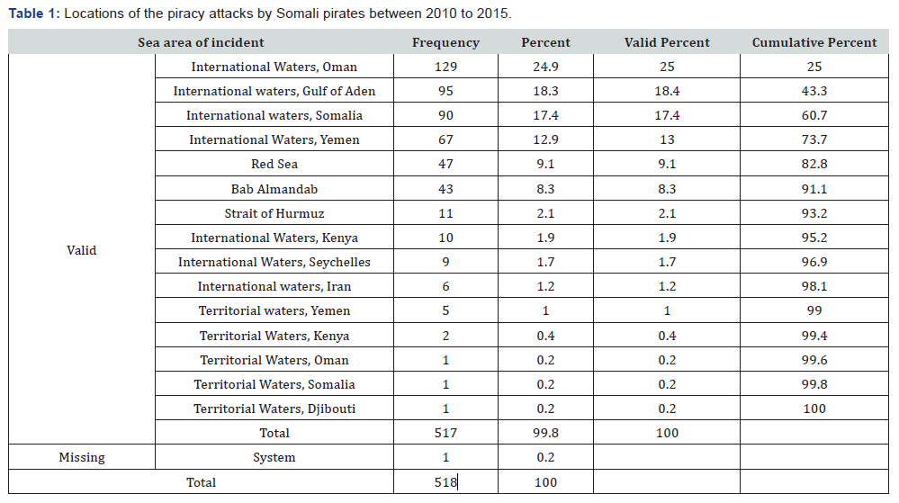
The following findings in Table 1 demonstrate the frequency statistics tables and charts focusing on the ten variables in the introduction to this study identified from the IMO piracy attacks reports:
Location
From Table 1, we can see that the most dangerous locations of piracy between January 2010 to March 2015 are the following: a) Omani international waters, 129 attacks 24.9% b) Gulf of Eden, 95 attacks 18.3% c) Somali international waters, 90 attacks 17.4% d) Yemeni international waters, 67 attacks 12.9% e) Red Sea, 47 attacks 9.1% f) Strait of Bab Al-Mandab, 43 attacks 8.3%
Oman has one of the most advanced and effective navies in the region as Oman is wealthier than other countries in the region such as Yemen and Somalia, yet as Table 1 shows, the most dangerous areas for piracy were Omani international waters. Oman is not a member of Combined Task Forces CTF 150, 151 or 152, demonstrating a head-in-the-sand attitude to the problem of piracy in the region. This table reflects supports the claims that international ignorance about piracy is one of the causes of is increase in certain areas [5,6].
Victim ship types
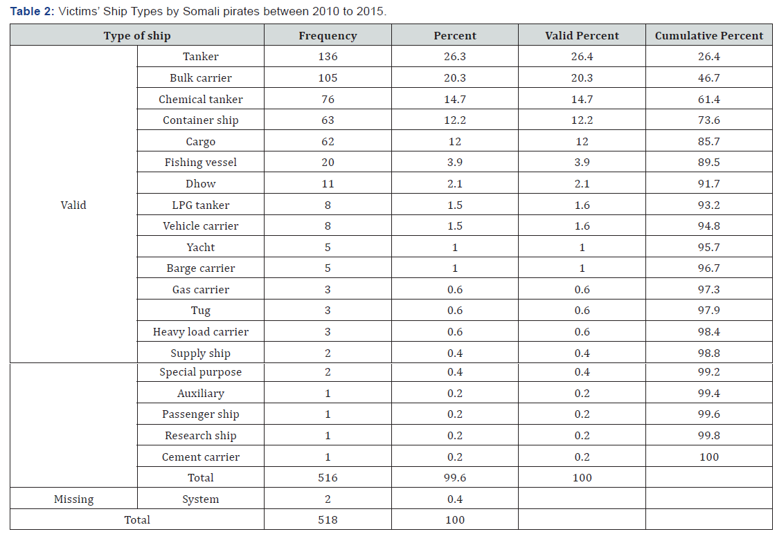
From Table 2, we can see that the types of ships most attacked are the followings making other ships less desired by the Somali pirates: i. Tankers, attacked 136 times 26.3% ii. Bulk carriers, attacked 105 times 20.3% iii. Chemical tankers, attacked 76 times 14.7% iv. Container ships, attacked 63 times 12.2% v. Cargo ships, attacked 62 times 12% The most desired ships chased by the Somali pirates are categorised by type (not flag) as shown in Table 2, indicating that Somali pirates are motivated to attack the ships based on the easiness of the target, not the nationality of the flag. This table supports the claim that some of the Somali pirates (not all) are not motivated by political or radical motives, as they do not target specific nation’s vessels [7,8].
Month
The Table 3 explains which months of the year were more dangerous for piracy between January 2010 and March 2015. From Table 3, we can see that the most common month for attacks committed by pirates is March, and the safest months are September, August, December and July [9,10].
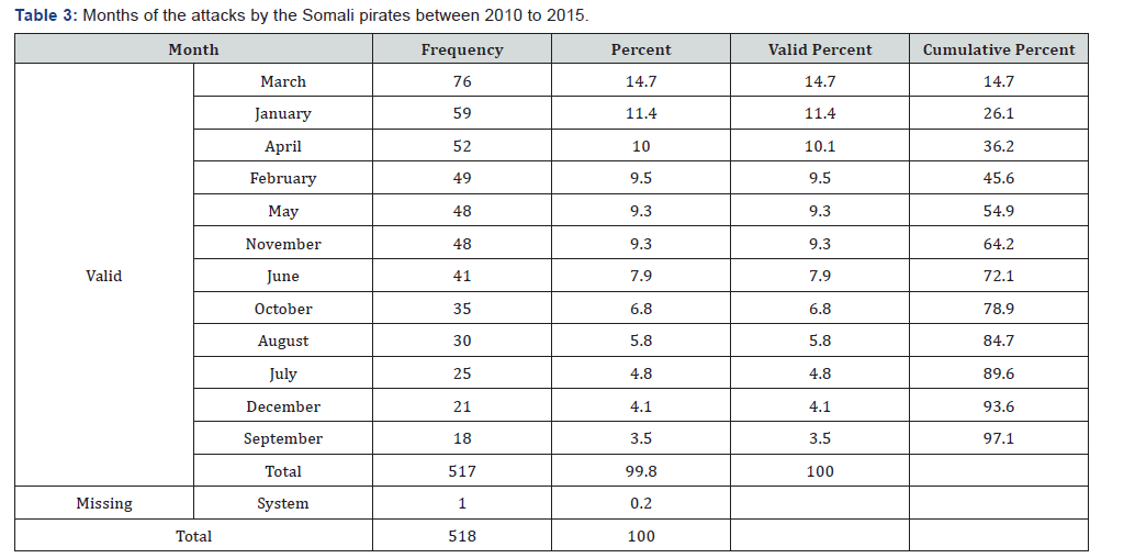
One reason why piracy attacks are less frequent in August, September and July is because of the monsoon season from May to September.
Another reason is Ramadan: The month of Ramadan is based on the Moon calendar, which is a holy month for Muslims who fast during Ramadan from sunrise to sunset. The followings are the attacks during Ramadan: • Ramadan 2010 was from 11 August to 10 September, during which there were 10 attacks, all of them during the day time, but nine of the attacks were in the early morning between 0400 to 0800 when the pirates can cope with piracy and fasting by avoiding the high temperatures in the afternoon. • Ramadan 2011 was from 1 August to 1 September, during which there were 16 attacks, four of which were during night time. Six of the 12 day time attacks were in the early morning between 0600 and 0700 when the weather is not very hot and pirates can cope with piracy and fasting. • Ramadan 2012 was from 20 July to 18 August, when there was only one attack, at 1200. • Ramadan 2013 was from 9 July to 7 August, when there was also only one attack, at 1500. • Ramadan 2014 was from 28 June to 28 July, when there were no attacks
Ramadan is one of the significant reasons which the Somali pirates decrease their activities during this month. Somali pirates fast during Ramadan, and they have no energy to be at sea all-day and looking for targets.
Day of the week
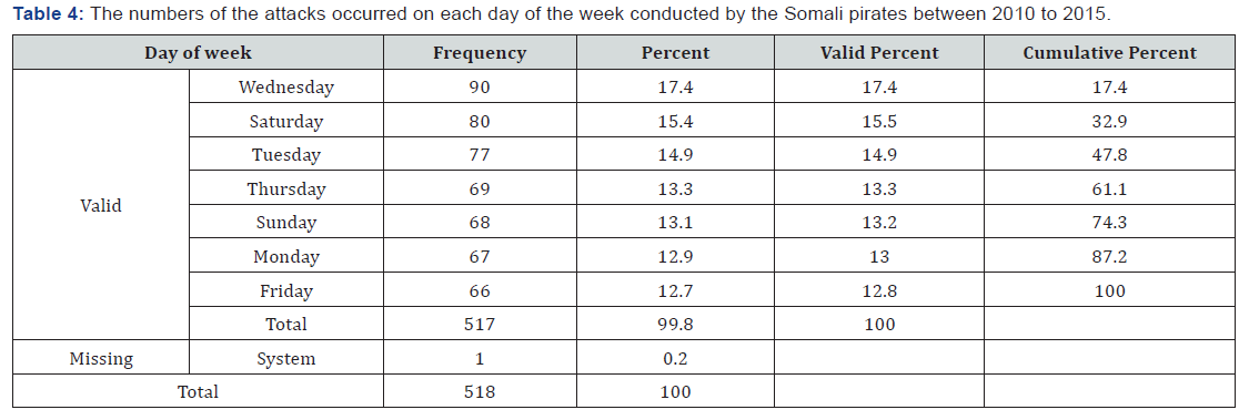
Table 4 indicates which day of the week is the most dangerous day for piracy and which day is the safest day for target ships to travel. From Table 4 Wednesday is the most dangerous day of the week and Friday is the safest. It may be that there are marginally fewer attacks on Fridays compared to other days because Friday is the holy day for Muslims, and Somalis will be in their mosques at noon (Friday prayers are compulsory for Muslims to practice) [10,11].
Day-time or night-time
Table 5 explains the number of attacks committed during daytime, and the number of attacks committed during nighttime. From the Table 5 and the figure above we can see that daytime is more dangerous than night- time for piracy attacks - 390 attacks being committed during day-time (75.3%) and 108 attacks being committed during night-time (20.8%) [12,13].

Wave height
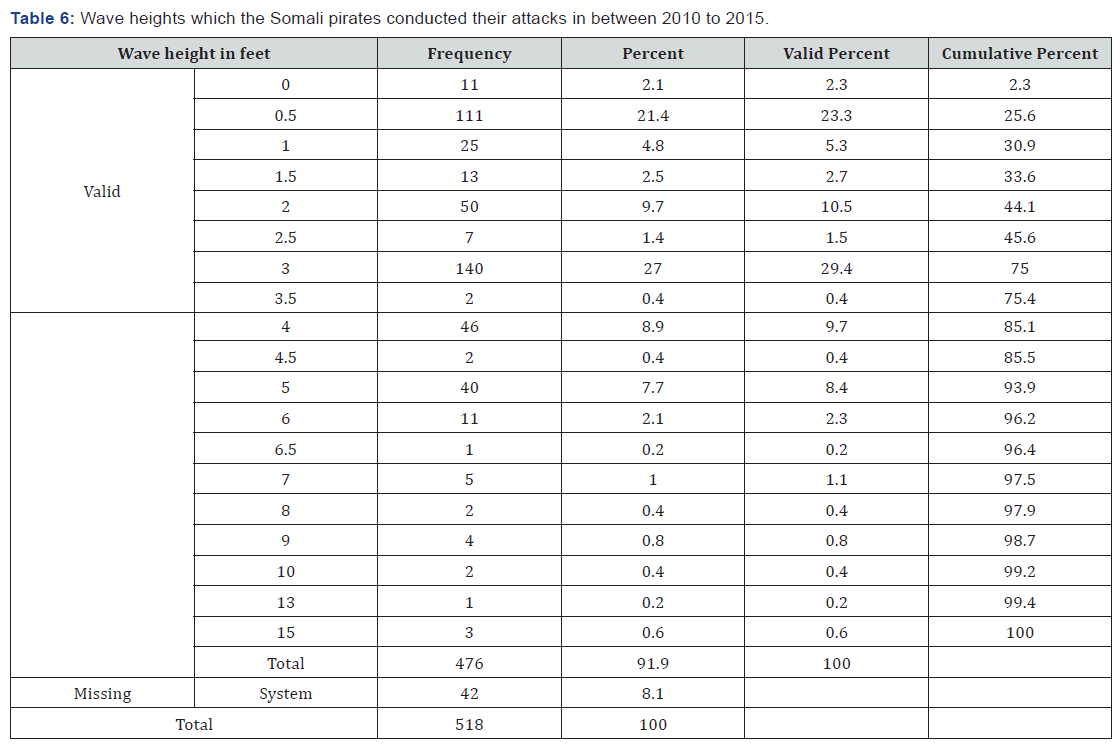
The following table and figure will show the wave heights when piracy attacks were committed, from which we can understand the effect of the sea’s state on maritime piracy. The wave height column on the left shows the actual wave height in feet and next to each height the frequency of the numbers of the attacks been committed to that height. At the end we will be able to understand what is the maximum practical wave height for the pirates to be able to board the ship which cannot operate in higher wave heights. From the Table 6 we can see that 357 (68.9%) piracy attacks were committed when the wave heights were 3 feet and below. At wave heights of between 3.5 and 6 feet, there were 101 piracy attacks (19.4%), and between 6.5 and 15 feet there were 18 piracy attacks (3.4%). The wave height factor is a very important issue that restricts the movement of the pirates. The pirates use relatively small skiffs to attack bigger ships in order to board them, and this technique needs experience and good seamanship skills. If the waves are high, this hinders pirates from making an approach, and makes it difficult for the pirates to deploy ladders to climb the ships [15,16].
Conclusion
From the analyses presented in this study, firstly, pirates are observed to be restricted by marine environment conditions such as high wave height and fast wind speeds as presented in section 2.7 and 2.8, so commercial ships can take advantage of this information when planning their routes or forming their security watches to minimise risk of attack. On a cautionary note, in practice it is difficult to prove a direct link between the decision-making of pirates of whether to attack or not and the prevailing weather conditions. However, the latter influences the implementation of approach and boarding a targeted vessel to be attacked. Secondly, Somali pirates prioritize tankers, bulk carriers, chemical tankers, containers, cargos, and then fishing vessels in terms of vessel type to attack. This suggests that Somali pirates select targets based on the type of vessel, not its flag (i.e. the nationality of its owner or crew). In other words, pirates are not motivated by ideological motives because if they were, they would attack specific flags. Thirdly, we find that fishing vessels come in at sixth place, which suggests that illegal fishing is not the most significant factor for piracy in Somalia. However, this assumes that fishing vessels have similar security to the other vessels. To conclude, from this synthesis of data analysis, Somali pirates select targets which are slow, with low free board, little protection, and potentially provide high prices for successful ransom negotiations.
References
- Buoyweather (2015) Wave, Wind and Period Charts of the Past.
- ICC CCS (2014) IMB Piracy & Armed Robbery Map 2014.
- ICC International Maritime Bureau (2009a) Piracy and Armed Robbery against Ships Report. London, United Kingdom.
- IDRE (2015) Annotated SPSS Output Descriptive statistics.
- IMB (2010) Piracy and Armed Robbery Against Ships: Report for the Period 1 January – 31 December 2010. United Kingdom.
- IMO (2015) Piracy Reports.
- IMO (2003) Reports on Acts of Piracy and Armed Robbery against Ships Annual report - 2003 (MSC.4/Circ.50). London: Organization,
- IMO (2004) Reports on Acts of Piracy and Armed Robbery against Ships Annual report - 2004 (MSC.4/Circ.64 ). London: Organization, I.M, UK.
- IMO (2005) Reports on Acts of Piracy and Armed Robbery against Ships Annual report - 2005 (MSC.4/Circ.81 ). London: Organization, I.M, UK.
- IMO (2006) Reports on Acts of Piracy and Armed Robbery against Ships Annual report - 2006 (MSC.4/Circ.98). London: Organization, I.M, UK.
- IMO (2007) Reports on Acts of Piracy and Armed Robbery against Ships Annual report - 2007 (MSC.4/Circ.115). London: Organization, I.M, UK.
- IMO (2008) Reports on Acts of Piracy and Armed Robbery against Ships Annual report - 2008 (MSC.4/Circ.133 ). London: Organization, I.M, UK.
- IMO (2009) Reports on Acts of Piracy and Armed Robbery against Ships Annual report - 2009 (MSC.4/Circ.152). London: Organization, I.M, UK.
- IMO (2010) Reports on Acts of Piracy and Armed Robbery against Ships Annual report - 2010 (MSC.4/Circ.169). London: Organization, I.M, UK.
- IMO (2011) Reports on Acts of Piracy and Armed Robbery against Ships Annual report - 2011 (2 June). London, UK.
- IMO (2012) Reports on Acts of Piracy and Armed Robbery against Ships Annual report – 2012 (MSC.4/Circ.193). London: Organization, I.M, UK.


