


Integrated Geographical Latitude Measurement and North-Seeking Technology and Method of Maglev Gyro Total Station in Confined Space of Mining
Zhiqiang Yang* and Yiwen Wang
School of Geology Engineering and Geomatics, Chang’an University, China
Submission: September 16, 2022; Published: September 23, 2022
*Corresponding author: Zhiqiang Yang, School of Geology Engineering and Geomatics, Chang’an University, China.
How to cite this article: Zhiqiang Y, Yiwen W. Integrated Geographical Latitude Measurement and North-Seeking Technology and Method of Maglev Gyro Total Station in Confined Space of Mining. Insights Min Sci technol.2022; 3(4): 555618. DOI: 10.19080/IMST.2022.03.555618
Abstract
The geographic latitude and the north azimuth are the basic parameters in geodesy. However, there is no preferable method to measure the geographic latitude and north azimuth in the confined space of mining where the global navigation satellite system (GNSS) is blocked, except for the conventional traverse surveying. Through long-term research on inertial technology and intelligent measurement, the authors proposed an integrated geographic latitude measurement and north-seeking method using a high-accuracy maglev gyro total station (GAT). The effectiveness and necessity of using the GAT in confined spaces have been verified by the application examples of several major mining projects. The concepts, methods, and applications of this technique are reviewed in this paper.
Keywords: High-accuracy Maglev Gyro Total Station (GAT); North-seeking; Geographical latitude Measurement; Mine surveying; Breakthrough Measurement; Confined Space
Abbreviations: GNSS: Global Navigation Satellite System; GAT: Gyro Total Station
Introduction
The geographic latitude and the north azimuth are the basic parameters in geodesy, which can be measured by modern high-accuracy surveying techniques, such as global navigation satellite system (GNSS), astronomical surveying, geodetic control network surveying, etc. However, there is no preferable method to measure the geographic latitude and the north azimuth in the GNSS-denied confined space of mines, except for the conventional traverse surveying [1].
The gyro total station (gyro-theodolite), which integrates the gyroscope and total station (theodolite), is a precise and sensitive measurement and directional instrument that can independently determine true north azimuths in confined spaces where GNSS signals are hardly received [2]. Therefore, it has been widely used in mine surveying, tunnel breakthroughs, subway construction, missile launching, weapons guidance, etc [3]. The gyro total station plays a crucial role in the surveying work of large-scale mining. On the one hand, it provides high-accuracy north orientation benchmark for mine surveying and ensures that measurement errors can be detected in time before penetration. On the other hand, it avoids the accumulation and expansion of errors with the extension of the tunnel, which effectively controls the lateral breakthrough error [1,3].
However, the traditional suspension-tape gyro-theodolites have problems of easy breakage of the suspension tape, poor environmental adaptability, and complicated operation. Meanwhile, the geographical latitude cannot be independently measured using a conventional gyro total station. The geographic latitude is not only a basic physical quantity for geodesy but also a necessary parameter for gyroscope north-seeking. However, in the GNSS-denied confined spaces such as mines and tunnels, geographic latitude is often not available.
To address these issues, a new type of high-accuracy maglev gyro total station (GAT) based on magnetic suspension-supporting and non-contact photoelectric torque feedback technology was jointly developed in 2008 by Chang’an University and the China Space Age Electronics 16th Research Institute for measuring north azimuth. The key strategy of the integration model of latitude measurement and north-seeking of the GAT is to calculate the geographical latitude by rotating the sensitive part of the gyroscope to several specified angles and measuring the torquer rotor and stator currents and inputting the obtained latitude into the north-seeking program to complete the orientation measurement [1,3].
By processing the non-stationary gyro signal through modern filtering techniques, the effective components can be extracted from the noisy signals, which improves the north-seeking accuracy [4,5]. The nominal orientation accuracy of the GAT was reported to 3.5′′ [3]. Since its advent, the GAT has been widely used in many major mining projects in China, such as Yushuwan Colliery, Cuijiagou Colliery, Tashan Colliery, etc., as well as several major underground projects, such as the immersed tunnel of the Hong Kong-Zhuhai-Macao Bridge and the Hanjiang River Diversion to the Weihe River Qinling Water Conveyance Tunnel, etc [1,3,5].
Methods
To solve the problem that using conventional gyro total stations cannot independently measure the geographic latitude and consequently cannot seek the north in the GNSS-denied confined space of mines, the GAT leverages the integrated geographic latitude measurement and north-seeking model. The structure of the GAT is illustrated in Figure 1. The specific process of the integration model of latitude measurement and northseeking of the GAT mainly includes the following steps.
Step 1: set up the GAT close to the north direction (±10°).
Step 2: geographic latitude measurement. Start the GAT and collect N sets of the torquer rotor current value IARi and the stator current value IASi in the stable levitation state at the 0° position of the goniometric system. To balance the duration and accuracy, we set the default N = 20000. Subsequently, the stepper motor drives the gyro-sensitive part (including: the inductance coil, the maglev ball, the photoelectric autocollimator, the gyro motor, and the torquer rotor, Figure 1) to rotate λ =2.5° counterclockwise. N sets of the torquer rotor current value IBRi and the stator current value IBSi in the stable levitation state were collected. The geographical latitude φ of the instrument location can be calculated by
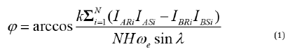

Here, k is a coefficient whose value depends on the system, H is the rotational inertia, ωe is the rotational angular velocity of the earth, and φ is the geographical latitude measured by the GAT.
Step 3: north-seeking. Collect N sets of the torquer rotor current value ICRi and the stator current value ICRi in the stable levitation state at the current position. Subsequently, the stepper motor drives the gyro-sensitive part to rotate 180° counterclockwise. N sets of the torquer rotor current value IDRi and the stator current value IDRi in the stable levitation state were collected. The gyro north azimuth α can be calculated by
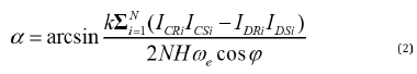
Here, φ is the geographic latitude obtained in Step 2. At this point, the integration of geographic latitude measurement and north-seeking has completed.
Applications
Since 2008, the GAT has been used widely for mine surveys in many major mining projects in China, such as Yushuwan Colliery, Cuijiagou Colliery, Tashan Colliery, Ningtiaota Colliery, Jianxin Colliery, Tongjin Mining, Shennan Colliery, Makeng Mining, Shirengou Mining, etc. In the Ningtiaota Colliery project, the GAT was used in the breakthrough measurement of a laneway of 26.7km long. The measured orientation accuracy of the GAT was better than its nominal accuracy, enabling the laneway to achieve a lateral breakthrough error of better than 7cm. In the survey project of a long lane in Tongjin Mining, the orientation accuracy of GAT was 2.3”, which ensured the precise breakthrough of the laneway. Through the application of these large-scale mining projects, the effectiveness and necessity of using the GAT in confined spaces such as mines and tunnels has been verified. In the future, the GAT will continue to be used in more and more mine surveying projects.
References
- Ma J, Yang Z, Shi Z, Liu C, Yin H, et al. (2019) Adjustment options for a survey network with magnetic levitation gyro data in an immersed under-sea tunnel. Surv Rev 51(2): 1-14.
- Li G, Huang S, Wang X, Li C, Zhang W (2020) A new alignment and breakthrough accuracy optimization strategy in long immersed tunnel surveys. IEEE Access 8: 228326-228336.
- Yang Z, Shi Z, Yang J (2017) North seeking principle and measurement application of magnetically suspended gyroscope. Surveying and Mapping Press, Beijing, China.
- Wang Y, Yang Z, Shi Z, Ma J, Liu D, et al. (2022) Periodic error detection and separation of magnetic levitation gyroscope signals based on continuous wavelet transform and singular spectrum analysis. Meas Sci Technol 33(6): 065107.
- Ma J, Yang Z, Shi Z, Zhang X, Liu C (2019) Application and optimization of wavelet transform filter for north-seeking gyroscope sensor exposed to vibration. Sensors 19(16): 3624.


