



 GJAA Home




Archaeological Heritage and Sugarcane Cultivation: Potential Impacts in Regions of Brazil and Colombia
Julio Cezar Rubin de Rubin1*, Carlos Eduardo López Castaño2, Martha Cecília Cano Echeverri3, Rosiclér Theodoro da Silva4, Jordana Batista Barbosa5, Idiandra Vieira dos Santos Alves6, Mário Pereira Mamede7 and Flávio César Gomes de Oliveira8
1Professor, Pontifical Catholic University of Goiás, Brazil
Researcher, National Council for Scientific and Technological Development – CNPq, Brazil
https://orcid.org/0000-0001-9789-2559
2Professor, Pereira Technological University, Colombia
https://orcid.org/0000-0001-9757-2475
3Professor, Pereira Technological University, Colombia
https://orcid 0-0002-3140-5807
4Professor, Pontifical Catholic University of Goiás, Brazil
https://orcid.org/0000-0003-0449-1663
5Postdoctoral Researcher in History, Pontifical Catholic University of Goiás, Brazil
https://orcid.org/0000-0002-0874-0877
6Pontifical Catholic University of Goiás, PhD Candidate - Graduate Program in Environmental Sciences and Health, Brazil
https://orcid.org 0009-0003-8196-8143
7Independent Archaeologist, Brazil
8Consam – Environment and Archaeology, Brazil
Submission:October 27, 2026; Published:November 09, 2026
*Corresponding author:Julio Cezar Rubin de Rubin, Professor, Pontifical Catholic University of Goiás, Goiano Institute of Prehistory and Anthropology, Avenida Universitária, 1440, Setor Universitário, CEP: 74605-010, Goiânia, Goiás, Brazil
How to cite this article: Julio Cezar Rubin de R, Carlos Eduardo López C, Martha Cecília Cano E, Rosiclér Theodoro da S, Jordana Batista B, et al. Archaeological Heritage and Sugarcane Cultivation: Potential Impacts in Regions of Brazil and Colombia. Glob J Arch & Anthropol. 2026; 15(1): 555902. DOI: 10.19080/GJAA.2026.15.555902
Abstract
Through methodological procedures specifically tailored to each study area, this paper examines the main impacts on archaeological heritage. The Serranópolis region, renowned for its significant concentration of archaeological sites featuring rock paintings and engravings, as well as evidence of human occupation dating back to the Early Holocene, faces an increasing threat from sugarcane cultivation. Agricultural activities associated with this expansion may alter or destroy archaeological sites, particularly open-air sites. In the alluvial plain of the middle Cauca River Valley, despite existing references to its archaeological potential, the region remains relatively understudied. Sugarcane cultivation is one of the factors contributing to this limited archaeological knowledge, while also intensifying threats to archaeological heritage. As a result, two action plans are proposed, focusing on the protection, preservation, and management of archaeological heritage in the respective study areas.
Keywords: Archaeological Heritage Management; Archaeological Sites and Impacts; Geoarchaeology
Introduction
Archaeological heritage is continuously exposed to direct and indirect impacts resulting from various processes of landscape transformation, particularly urban expansion, deforestation, agricultural and livestock activities, and the development of hydroelectric, road infrastructure, and urban development projects. In this context, the expansion of sugarcane cultivation represents a significant driver of land-use change, as observed in Serranópolis, in southwestern Goiás State, Brazil, and in the middle Cauca River Valley, Colombia.
Although separated by approximately 7,000 km and situated within distinct historical, environmental, and socioeconomic contexts, both regions face similar challenges concerning the pressures exerted by productive activities on areas of archaeological interest, despite their individual characteristics. This paper aims to provide a comparative analysis of these two regions, identifying similarities and specificities and, on this basis, proposing fundamental management measures aimed at the protection, preservation, and safeguarding of archaeological heritage.
Mamede's [1] master's dissertation addresses this topic, providing the foundation for the discussion of the archaeological context of Serranópolis, complemented by findings from research conducted at the GO-Ja-02 archaeological site (Gruta do Diogo 2) [2,3]. Information concerning the middle Cauca River Valley, in west-central Colombia, is based on data collected by Dr. Carlos López Castaño and Dr. Martha Cecilia Cano Echeverri through academic and preventive archaeological investigations [4,5,6].
The municipality of Serranópolis covers an area of approximately 5,526 km², according to data provided by the Municipal Government of Serranópolis [7]. Its economy is characterized by agricultural and livestock activities, particularly cattle ranching and the cultivation of corn, soybeans, sorghum, and sugarcane. The region contains a significant concentration of archaeological sites, including rock shelters and open-air sites featuring rock art (paintings and engravings), lithic and ceramic remains, and human burials, as well as evidence of human modification of the landscape dating back approximately 12,000 years Before Present (BP) [2,3,8,9]. Cultural ecotourism also plays an important role in the region, particularly through initiatives promoted by the Association of Expedition Tourism Guides of Serranópolis (Associação dos Condutores de Turismo de Expedições de Serranópolis - ACOTES) and the Pousada das Araras Wildlife Sanctuary Reserve (RPPN Reserva Santuário de Vida Silvestre Pousada das Araras).
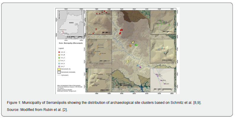
More than 50 archaeological sites have been registered in Serranópolis in the National Registry of Archaeological Sites (Cadastro Nacional de Sítios Arqueológicos - CNSA), maintained by National Institute of Historical and Artistic Heritage (Instituto do Patrimônio Histórico e Artístico Nacional - IPHAN). These sites provide evidence of successive human occupations dating back to the Early Holocene, encompassing hunter-gatherer groups and later agricultural and pottery-producing populations. Archaeological investigations in the region began in the 1970s under the coordination of Dr. Pedro Ignácio Schmitz and Dr. Altair Sales Barbosa, who organized the sites into clusters designated by the letters “A” through “F” (Figure 1). In 2021, academic archaeological excavations resumed in the region, incorporating new research approaches, particularly at the GO-Ja-02 site, which belongs to Cluster “A”. These investigations have been conducted by researchers from the Pontifical Catholic University of Goiás [2,3].
The landscape configuration, predominantly characterized by plateau landforms, regionally referred to as chapadas or chapadões, with relatively flat summits, residual hills (primarily resulting from weathering processes), valleys of varying dimensions, and a geological substrate composed mainly of basalt and sandstone, favored both precolonial human occupation [2,8,9] and the settlement of Southern Kayapó and Bororo Indigenous groups (reference needed), as well as successive waves of colonial settlement and migration, which intensified particularly from the 1950s onward [10-12].
For the first two groups, considering their respective particularities, factors such as the availability of shelters, water resources, high-quality raw materials for the production of material culture, particularly lithic and ceramic artifacts, and naturally fertile soils were undoubtedly important variables influencing the selection and occupation of these areas. For the third group, the availability of water, naturally fertile soils, and relatively flat terrain favored the development of agricultural and livestock activities.
Therefore, certain shared environmental attributes can be identified that, at different times, contributed to the attraction, occupation, and appropriation of these landscapes by distinct human groups. This recurring pattern resulted in overlapping land uses, occupations, and forms of spatial appropriation, generating a range of impacts on the archaeological evidence and material traces of human occupation accumulated over time [2,3,13].
According to Ribeiro and Walter [14], the climate of Central-Western Brazil is characterized by two well-defined seasons: a rainy summer, with average annual precipitation of approximately 1,500 mm, and a dry winter. The authors emphasize that the contrast between lower-lying surfaces (below 300 m), extensive plateaus ranging from 900 to 1,600 m, and the broad latitudinal distribution of the Cerrado contributes to considerable thermal variability across the biome (p. 89). Temperatures range from approximately 18°C during the rainy season to values currently reaching 37°C during the dry season.
These environmental characteristics, combined with the availability of water resources, raw materials, soils, and diverse landforms, contributed to the development of landscapes favorable to human occupation during different periods. The diversity and long-term continuity of these occupations have attracted the attention of archaeological research projects in the region since the second half of the twentieth century. In this regard, understanding the archaeological record of Serranópolis also requires consideration of the theoretical and methodological changes that have shaped the development of archaeological research in this territory.
Archaeological investigations conducted between the 1970s and 1990s were predominantly grounded in the principles of the culture-historical approach, emphasizing the identification, description, and classification of archaeological remains and the establishment of cultural sequences. The resumption of research at the GO-Ja-02 archaeological site in 2021 adopted a different perspective, guided by new research questions and the incorporation of methodological procedures and theoretical frameworks associated with processual and post-processual archaeology.
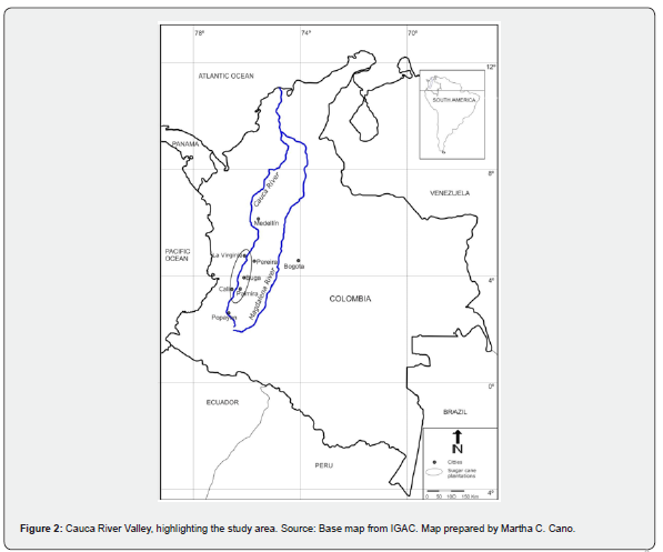
The inter-Andean middle Cauca River Valley (Figure 2) is characterized by an extensive alluvial plain stretching approximately 230 km, at elevations ranging from 900 to 1,000 m above sea level. Mean annual temperatures range from 22°C to 24°C, with annual precipitation between 1,000 and 2,000 mm. Although the landscape was historically dominated by lacustrine and marshland environments surrounded by humid and dry lowland tropical forests, it is now predominantly occupied by extensive sugarcane monocultures, covering approximately 240,000 hectares, alongside other large-scale agricultural plantations and pasturelands used for livestock production [15].
Archaeological excavations at several sites, particularly along the slopes of the Andean mountain ranges, began in the 1940s [16]. However, it was not until the 1980s and 1990s that the first systematic archaeological investigations were conducted in the alluvial plain [17]. During the late nineteenth and early twentieth centuries, several archaeological sites were looted due to the abundance and exceptional quality of their gold artifacts, particularly in the region known as Calima [17].
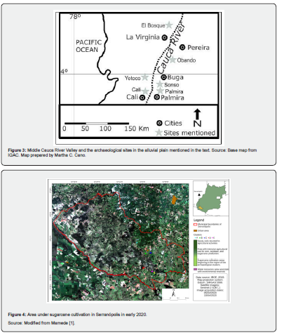
In 1992, workers employed in the sugarcane industry reported the discovery of the Malagana burial ground in Palmira, an archaeological site of considerable significance due to the quality and quantity of its material culture, especially its goldwork artifacts. Unfortunately, the site was extensively looted. Subsequent investigations, discussed in the following sections, have provided essential evidence concerning the pre-Hispanic populations that inhabited this important region of west-central Colombia [17-21] (Figure 3).
Archaeological research in the middle Cauca River Valley has evolved from regional approaches primarily focused on ceramics and metallurgy to integrated studies combining chronology, funerary practices, bioarchaeology, and landscape archaeology [18,22,23]. Each researcher has contributed valuable insights that, when considered collectively, provide a more comprehensive and nuanced understanding of the pre-Hispanic societies that inhabited the Cauca River alluvial plain and its surrounding slopes, as well as their internal dynamics and interactions with neighboring regions.
Materials and Methods
The Materials and Methods are Presented Separately for each Study Area
Serranópolis
For the Serranópolis region, the analyses were conducted using an integrated approach combining a literature review, spatial analysis, and field investigations. The precolonial context of the study area was established based on Schmitz et al. [8,9], as well as more recent contributions, such as those by Rubin et al. [24-26], which provide new perspectives on the archaeological heritage of the region [1]. Additional academic sources, including doctoral theses, master's dissertations, and scientific articles, were also consulted, particularly Rubin et al. [2,13] and Barbosa [3].
To delineate the study area and assess the spatial proximity between sugarcane plantations and archaeological site clusters, satellite imagery obtained from Google Earth and SIEG Mapas (IBM–Segplan/IBGE) was used. These data were processed and organized within a Geographic Information System (GIS) and were essential for characterizing the study area. This approach enabled the identification of changes in the regional landscape configuration, revealing the progressive expansion of cultivated areas into the surroundings of archaeological site clusters and the potential associated environmental and cultural impacts [1].
The spatial analysis enabled the identification of areas of overlap between cultivated land and archaeological site clusters, providing a basis for collecting and recording data on the effects of agricultural activities on local cultural heritage. The methodological framework adopted made it possible to map the main impact drivers associated with sugarcane monoculture on the region's archaeological heritage [1, 27].
Specific fieldwork campaigns were conducted in September 2021 and August 2022, including visits to archaeological sites, photographic documentation, and the identification and description of areas potentially susceptible to impacts from sugarcane cultivation [1,27]. Additionally, the study area was progressively examined during successive fieldwork campaigns carried out as part of the Serranópolis Project between 2021 and 2025.
Collectively, these fieldwork activities enabled an assessment of the archaeological contexts associated with each archaeological site cluster, with particular emphasis on archaeological heritage protection and management. It is worth noting that, following the resumption of archaeological investigations, research has also expanded to encompass related fields, including paleoenvironmental studies, geophysics, bioarchaeology, zooarchaeology, geoarchaeology, and landscape archaeology, as well as new approaches to the analysis of material culture through the application of multielemental analytical techniques.
Cauca River Valley
Archaeological investigations conducted in the Cauca River Valley alluvial plain have employed a combination of traditional archaeological methods and interdisciplinary approaches adapted to the particular characteristics of a dynamic and extensively transformed alluvial landscape. Early research primarily emphasized systematic surface surveys, archaeological site recording, and ceramic typology as methodological tools for establishing cultural sequences and identifying areas of human occupation [16,28].
Subsequently, controlled stratigraphic excavations were incorporated into archaeological investigations of both habitation and funerary contexts, alongside preventive archaeology, which became essential in response to urban, agricultural, and industrial expansion [5]. These methods enabled the documentation of settlement patterns, artifact distributions, and funerary practices, particularly in areas such as Palmira, Buga, and the surroundings of Sonso Lagoon, where numerous archaeological contexts are partially or completely buried beneath alluvial deposits [21].
Furthermore, since the late twentieth century, an interdisciplinary and environmental approach has become increasingly established, integrating geoarchaeological, geomorphological, pedological, and paleoecological methods to investigate the relationships between human occupation and fluvial dynamics. Analyses of sediments, buried soils, paleochannels, pollen, phytoliths, and charcoal have enabled the reconstruction of environmental changes, flooding events, drought periods, and potential early agricultural practices [18,22,23].
These approaches have been complemented by bioarchaeological and paleopathological studies of funerary contexts, as well as the application of Geographic Information Systems (GIS) and historical cartography to model land-use patterns. Together, these methodologies have facilitated an integrated interpretation of the archaeological record of the Cauca River Valley, connecting material culture, landscape, environment, and social practices within a complex alluvial setting [5,17,19].
The distinct environmental, landscape, social, and economic contexts of Serranópolis and the Cauca River Valley highlight the specific characteristics of each study area, both in terms of the methodological procedures employed and the results obtained. These differences allow the archaeological contexts to be examined either individually, while respecting their particularities, or through an integrated comparative approach. Such an approach enables the identification of similarities, differences, and shared processes associated with human occupation, land use, and landscape transformation.
Results and Discussion
The results and discussion address the particularities, similarities, and differences between the two study areas, with the aim, as previously stated, of proposing measures for archaeological heritage management in both regions.
Serranópolis
When examining Serranópolis, it is important to situate the region within the context of the Green Revolution, which began in the 1960s and was characterized by the increasing predominance of agricultural mechanization and the use of agricultural inputs at the expense of traditional farming practices, as highlighted by Graziano Neto [29]. Barbalho and Campos [30, p. 159] report an 81% increase in the area under sugarcane cultivation between the 1999/2000 and 2003/2004 harvest seasons. Ribas [31] indicates that sugarcane production in Goiás gained recognition around 1990. According to the Brazilian National Supply Company [32], the area planted with sugarcane in Goiás reached approximately 971,600 hectares, with production totaling 74.1 million metric tons during the 2020/2021 harvest season.
In this context, particular attention should be given to the new Agricultural Climate Risk Zoning (Zoneamento Agrícola de Risco Climático — ZARC) for sugarcane cultivation, which states that:
“(...) the area under sugarcane cultivation in Brazil ranged from 9.1 to 10.2 million hectares over the past ten years. The highest concentration is found in the states of the Center-South region, particularly São Paulo, which accounts for approximately 50% of the country's sugarcane plantations. Goiás ranks second, with 11%, followed by Minas Gerais in third place, with 10% of the total cultivated area.” (33, p. 110).
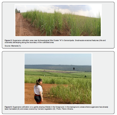
The data presented above highlight the expansion of sugarcane cultivation in Goiás and provide a basis for a preliminary assessment of its potential impacts. Three main processes are particularly relevant to the archaeological heritage of Serranópolis: erosional processes, soil loss, and soil preparation for planting.
Erosional processes, including rills, channels, gullies, and large gullies, result from the combined effects of rainfall erosivity, soil erodibility, raindrop impact on exposed soil surfaces, and subsequent sheet and concentrated runoff, particularly when rainfall intensity exceeds the soil infiltration capacity. These processes can be observed throughout the municipality. For further details on erosional processes, see DAEE/IPT [34], Rotta and Zuquette [35] and Alves et al. [36].
Soil loss, which is often confused with erosional processes, is assessed by considering a range of variables and is frequently estimated using the Universal Soil Loss Equation (USLE). This model incorporates rainfall erosivity, soil erodibility, topographic factors, cover and management practices, and soil conservation measures [37].
Rosa et al. [38] emphasize that soil loss in the Paraná River Basin, which encompasses part of southwestern Goiás, including the municipality of Serranópolis, was estimated at 4.4 t ha⁻¹ yr⁻¹ in 1985, increasing to 16.0 t ha⁻¹ yr⁻¹ in 2000 and reaching 15.6 t ha⁻¹ yr⁻¹ in 2018.
Regarding sugarcane planting, Dematté [39, p. 11] describes three stages of soil preparation. During the second stage, which coincides with the onset of the rainy season, deep soil tillage is performed through subsoiling at depths of 40–45 cm or plowing to a minimum depth of 35 cm (authors' translation).
These three processes directly affect archaeological remains, including lithic artifacts, ceramic materials, and combustion features. They may cause both horizontal and vertical displacement of archaeological materials, thereby altering their original archaeological contexts or even covering and burying them. Furthermore, these processes may result in the redeposition of archaeological evidence in secondary contexts, particularly at open-air archaeological sites.
With regard to archaeological sites located in rock shelters, erosional processes and soil loss are also relevant, particularly when they occur upslope from the shelters and affect their stability, as discussed by Rubin et al. [25]. However, the impacts associated with the use of agricultural pesticides, particularly those applied through aerial spraying and subsequently transported by wind, have not yet been adequately assessed. Questions such as “What effects do agricultural pesticides have on rock surfaces?” and “How do these substances affect rock paintings and engravings?” remain fundamental and largely unanswered.
Mamede [1] also examines the use of agricultural pesticides, particularly those associated with sugarcane cultivation in southwestern Goiás State. Approximately 79 distinct active ingredients are estimated to be used in sugarcane production, many of which exhibit a high potential for environmental dispersion.
Other issues associated with agricultural activities that have not been extensively investigated concern the use of heavy machinery, including tractors, trucks, harvesters, and other equipment. Such machinery may damage or destroy open-air archaeological sites through the horizontal and vertical displacement of cultural materials, as previously discussed in relation to soil preparation for planting. Furthermore, agricultural activities may introduce chemical substances into soil and sediment profiles Mamede [1]. Consequently, X-ray fluorescence (XRF) and X-ray diffraction (XRD) analyses of archaeological soils and sediments may be compromised, representing an additional potential impact on cultural heritage, particularly when these deposits are regarded as artifacts in their own right.
Siqueira et al. [40] presented data concerning soil properties, highlighting processes of soil nutrient depletion and degradation. In this context, XRF and XRD analyses of archaeological soils and sediments may also be affected by the loss of elements associated with past human occupations.
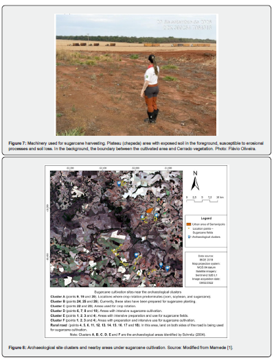
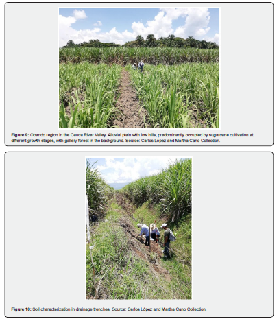
Figure 4 illustrates the area occupied by sugarcane cultivation in Serranópolis in 2020. Figures 5-7 indicate locations associated with land use for sugarcane cultivation, while Figure 8 shows the distribution of archaeological site clusters in relation to areas under sugarcane cultivation.
Another activity associated with the sugarcane production cycle that is often overlooked is the use of fire to expand cultivation areas and burn sugarcane straw. Although agricultural burning is prohibited under the legislation currently in force, this practice was permitted until relatively recently. Returning to the archaeological implications, thermoluminescence (TL) and optically stimulated luminescence (OSL) dating of archaeological ceramics, sediments, and soils may be compromised by exposure to high temperatures and associated environmental conditions [1].
Regarding OSL dating, Jain et al. [41] discuss issues related to light exposure, while Jeong et al. [42] examine the effects of weathering processes. Oliveira [43] addresses the potential underestimation and overestimation of dating results associated with contexts affected by anthropogenic land use. Concerning TL dating, Watanabe et al. [44, p. 390] identify several conditions necessary to obtain reliable results, emphasizing the importance of information regarding “sampling depth, whether the surface has been subjected to burning, and whether the sample has been exposed to intense solar radiation” (authors' translation).
Landscape transformations associated with the sugarcane production cycle also erase important traces of long-term human occupation, as discussed in the Introduction, representing a significant loss for cultural heritage research. The use of remote sensing datasets from multiple sources, combined with field investigations aimed at identifying evidence of natural processes, human activities, or their overlapping effects, as discussed for the region by Rubin et al. [2,13,25,26], Mamede [1], and Barbosa [3], can help mitigate these impacts.
In Serranópolis, rock shelter and open-air archaeological sites are affected in relatively different ways. Considering the context discussed above, an important question arises: are any of these impacts truly indirect? If we consider that the processes described also have consequences for other dimensions of archaeological heritage, including knowledge production, heritage education, and management planning, the answer is no. Rather, these processes represent a direct and cumulative sequence of impacts that, depending on their intensity, may ultimately lead to the destruction of archaeological heritage.
Cauca River Valley
In the Cauca River Valley, the impacts associated with the sugarcane production cycle are primarily related to land use in the warm lowland areas corresponding to the alluvial plain. Sugarcane cultivation takes advantage of the relatively flat terrain, which contains significant archaeological evidence associated with the earliest human groups to occupy the region.
The central inter-Andean region of Colombia is characterized by numerous tributaries flowing into the lowlands, where the Cauca River crosses an extensive alluvial plain at elevations ranging from 900 to 1,000 m above sea level. It is important to emphasize that most of the earliest identified archaeological sites, dating from more than 5,000 to approximately 10,600 years Before Present (BP), are located in small tributary river valleys, at average elevations of approximately 1,500 m above sea level.
Archaeological excavations have revealed a long and diverse history of human occupation, with evidence dating back to the Early Holocene and becoming more intensive during the pre-Columbian agroceramic periods [16,18,20]. Only one preceramic archaeological site has been excavated on a Cauca River terrace, near the mouth of the Mapa River, indicating human occupation during the seventh millennium BP [6].
These findings indicate that the alluvial plain was not a marginal area but rather a territory actively occupied and managed by societies that developed adaptive strategies in response to a highly dynamic fluvial environment. The combination of pre-Hispanic human occupations, dynamic environmental conditions, contemporary anthropogenic activities, particularly those associated with sugarcane cultivation, and the limited number of academic archaeological investigations places the region at considerable risk of impacts on its archaeological heritage.
Among the main archaeological findings, ceramic remains stand out as the most frequently identified archaeological indicators in the mountainous areas, also serving as important chronological and cultural references for the alluvial plain. Typological and technological analyses of these materials have enabled the establishment of cultural sequences associated with the Ilama, Yotoco, and Sonso traditions, as well as the identification of local variations within the Cauca River Valley [21,28]. However, these materials are frequently recovered from fragmented and reworked archaeological contexts, supporting the observations discussed previously.
Archaeological investigations in the municipalities of Cali and Palmira have also documented funerary contexts and burial grounds, generally situated in slightly elevated areas of the alluvial plain or within transitional zones leading to more stable river terraces. Bioarchaeological studies of these contexts have contributed to a better understanding of ritual practices, social organization, and the living conditions of pre-Columbian populations [19,21], although skeletal preservation varies considerably due to local soil conditions.
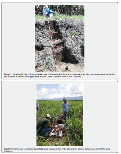
Figures 9-12 illustrate some of the activities taking place on the Cauca River alluvial plain, particularly those associated with sugarcane cultivation and archaeological investigations.
One of the most significant findings from archaeological investigations in the lowlands of the Cauca River Valley concerns the low archaeological visibility of the alluvial plain. The fluvial dynamics of the Cauca River, characterized by recurrent flooding and sediment deposition, have resulted in the deep burial of numerous archaeological sites, making their detection through surface surveys particularly challenging [23]. Sugarcane plantations occupy extensive areas where access permits are difficult to obtain, resulting in limited information regarding the presence and distribution of archaeological remains.
The spatial and temporal resolution of the archaeological record is also constrained by post-depositional processes that cause stratigraphic disturbances and artificial associations between materials from different chronological periods. Consequently, geoarchaeological and paleoenvironmental approaches have been essential for accurately interpreting these contexts [22,23].
Paleoecological studies based on analyses of pollen, phytoliths, charcoal, and buried soils have provided valuable information on environmental changes, burning events, and potential ancient agricultural practices, enabling correlations between human occupation and climatic and hydrological variability [23].
A critical issue widely discussed in the literature concerns the destruction of the archaeological record associated with intensive sugarcane cultivation. Mechanized agricultural activities, including land leveling, drainage operations, and deep subsoiling, have caused the irreversible loss of numerous archaeological sites across the Cauca River Valley alluvial plain [17,19].
Given the extensive areas occupied by sugarcane plantations, there is limited oversight of interventions affecting the soil and subsurface deposits. Most archaeological evidence consists of ceramic sherds and lithic artifacts that are frequently displaced, mixed, and redeposited, often without being reported. A major concern is the limited knowledge of stratigraphic contexts, particularly buried soils that provide evidence of both agroceramic and preceramic occupations.
Consequently, much of the available archaeological knowledge derives from preventive and rescue archaeology, resulting in spatial and chronological biases in the archaeological data. Nevertheless, these investigations have been essential for documenting areas where intact archaeological contexts are no longer preserved [5,19].
Preventive archaeological investigations conducted along the La Virginia–Asia highway, in the region known as Eje Cafetero, led archaeologists Carlos Restrepo and Angela Barco to undertake the rescue excavation of the first preceramic archaeological site identified in lowland areas below 1,000 m above sea level. Although dozens of ancient archaeological sites dating back several millennia have been documented in temperate-climate areas, the El Bosque site, located on a terrace of the Risaralda River in the municipality of Belalcázar (Caldas), was the first to provide evidence of human occupation in the lower river basins of west-central Colombia. In Excavation Unit 1, lithic artifacts and charcoal samples were recovered at a depth of 120 cm, yielding a radiocarbon age of 7,250 ± 30 BP (5,300 BC). Although further investigation from a geoarchaeological perspective is still required, it is essential to emphasize the depth of these findings and the significance of stratigraphic sequences at archaeological sites currently covered by pasturelands or sugarcane plantations [6].
It is particularly significant that archaeological investigations based on surface surveys and generally concentrated within the uppermost meter of subsurface deposits have frequently failed to identify preceramic or even early ceramic occupations. This pattern suggests the deep burial of ancient archaeological contexts, potentially resulting from the deposition of volcanic ash originating from volcanoes in the Central Cordillera, as well as alluvial sedimentation associated with streams and rivers descending from the mountain ranges and flooding events involving the Cauca River and its tributaries [4,5].
Overall, the findings indicate that the Cauca River Valley alluvial plain constituted a culturally shaped landscape in which pre-Columbian populations adopted flexible settlement strategies, balancing the advantages of fertile soils with the persistent risk of flooding [20,28].
In summary, this discussion highlights the need to expand interdisciplinary approaches, subsurface detection methods, and archaeological heritage protection policies, particularly considering the extensive landscape transformations caused by the contemporary sugarcane agroindustry.
Final Considerations
The sugarcane production cycle plays a significant social and economic role in the regions examined in this study. However, with regard to cultural heritage, it generates direct and irreversible impacts, both documented and estimated. Numerous discussions have addressed this issue, and given the complexity of the economic, social, environmental, and political factors involved, identifying an approach that reconciles these different interests remains a difficult and challenging task.
In the two study areas, distinct environmental and archaeological contexts can be identified. Serranópolis is characterized by a diversity of landforms and archaeological sites containing evidence of human occupation dating back to the Early Holocene, including both rock shelters and open-air sites affected by the sugarcane production cycle. Among the main impacts identified are erosional processes, soil loss, soil disturbance and compaction, and the use of agricultural pesticides.
In the Cauca River Valley, the alluvial plain constitutes the principal geographical focus of the investigation and also contains archaeological sites with evidence of ancient human occupation. In this region, drainage trenches, soil disturbance, erosional processes, fluvial channel dynamics, and volcanic activity stand out as significant factors affecting archaeological contexts. Thus, the two regions present both similarities and differences, context-specific assessments, and challenging future scenarios, raising a fundamental question: How can archaeological heritage be effectively managed and protected? Accordingly, the recommendations presented here are primarily concerned with the protection and preservation of cultural heritage.
In addressing this issue, Mamede [1] proposed a series of measures, including strengthened regulatory oversight, archaeological investigations in cultivated areas, the protection of buffer zones surrounding archaeological sites, and regular monitoring. These recommendations are broad and appropriate for the region, where archaeological investigations have been conducted since the 1970s and agribusiness plays a prominent role.
In this context, considering the environmental characteristics of Serranópolis, including its paleoenvironments, landscapes, and archaeological records from both precolonial and colonial periods, we initially propose the development of an Environmental and Cultural Zoning Plan for Serranópolis as a strategy for archaeological heritage management, protection, and preservation. This proposal expands upon the approach presented by Oliveira et al. [45], who discuss the protection of archaeological sites belonging to Cluster F based on a natural vulnerability map for soil loss.
Another issue requiring urgent attention, as emphasized by Mamede [1], concerns the use of agricultural pesticides and their potential impacts on the rock paintings and engravings found at archaeological sites within the Serranópolis Archaeological Complex. This represents a serious and often overlooked concern, generally recognized by individuals who live or conduct research in the region and closely observe activities associated with agribusiness.
Regarding the Cauca River Valley, the alluvial plain constitutes a large-scale and highly complex archaeological landscape, covering approximately 230,000 hectares and containing an archaeological heritage that remains poorly understood and insufficiently documented. The terraces along the Cauca River provide a wide range of ecological opportunities. As new archaeological data become available, it will be possible to gain a better understanding of the relationships between these lowland environments and the populations documented in nearby mountainous areas, where climatic conditions are more favorable.
Although archaeological remains are not always visible on the surface, accumulated evidence from excavations, paleoenvironmental studies, and chance discoveries demonstrates the presence of buried archaeological contexts, some of which are associated with very early human occupations. This low surface visibility should not be interpreted as an absence of archaeological heritage, but rather as a consequence of the geomorphological and sedimentary processes characteristic of a dynamic alluvial environment.
A particularly relevant aspect of archaeological heritage management in this region is the presence of sedimentary deposits associated with volcanic events, which have contributed to the burial and, in some cases, preservation of ancient archaeological contexts. These volcanic deposits, combined with fluvial sedimentation, have produced complex stratigraphic sequences that require specialized methodologies for their identification and interpretation. In this regard, archaeological investigations in the Cauca River Valley cannot rely exclusively on surface surveys but require in-depth, interdisciplinary, and long-term research.
The limited extent of archaeological research across large sectors of the alluvial plain is also associated with social and economic constraints, particularly the historical concentration of landownership in large agroindustrial estates and the difficulties of gaining access to extensive properties devoted to intensive sugarcane cultivation. These conditions have restricted systematic archaeological surveys and created substantial gaps in the available data, suggesting that a significant proportion of the region's archaeological heritage remains unrecorded and, consequently, vulnerable to destruction without prior documentation.
In this context, it is essential that infrastructure projects, agricultural expansion, urbanization, and construction activities of all scales explicitly consider the high potential for impacts on archaeological resources, even in areas where no archaeological evidence is visible on the surface. Experience gained from archaeological investigations in the region demonstrates that many remains are only discovered during deep earthmoving operations, when archaeological contexts have already been partially or completely disturbed. Therefore, early planning and preliminary archaeological assessments should be regarded as essential components of land-use planning and territorial management.
The rigorous implementation of Archaeological Management Plans (Planes de Manejo Arqueológico — PMA) constitutes a central instrument for the protection, documentation, and responsible management of archaeological heritage in the Cauca River Valley. These plans should encompass not only archaeological rescue activities but also strategies for prevention, monitoring, research, and public engagement, integrated with geomorphological, paleoenvironmental, and historical land-use studies. Furthermore, PMAs must be designed with consideration for the regional scale of the archaeological landscape, rather than being restricted to the specific boundaries of individual development projects.
The Cauca River Valley alluvial plain and the Serranópolis region should be recognized as areas of high archaeological sensitivity, whose heritage represents a scientific, historical, and cultural resource of considerable significance. Advancing knowledge and strengthening the protection of these archaeological contexts require overcoming access restrictions, expanding interdisciplinary research, and implementing heritage management strategies capable of bringing together researchers, academic and cultural institutions, the productive sector, and public authorities. Collaboration among these stakeholders is essential not only to ensure the continuity of archaeological research but also to promote the recognition, safeguarding, and preservation of archaeological heritage, securing its transmission to future generations.
References
- Mamede MP (2023) Sugarcane cultivation in southwestern Goiás and the impacts on the archaeological heritage of Serranópolis, Goiás (2000-2020). Master's thesis in History, Pontifical Catholic University of Goiás, Goiânia, Brazil.
- Rubin JCR, Barbosa JB, Wesolowski V, Viana AS, Borges WR, et al. (2025) Resumption of research at the archaeological site GO-JA-02 (Gruta do Diogo 2), Serranópolis, Goiá In: Rubin JCR, Barbosa JB (eds.), Archaeology: the past and the layers of time Curitiba: CRV Editora.
- Barbosa JB (2025) Stratigraphy, archaeology and the Holocene paleoenvironment of the GO-JA-02 site: A window to the past in Serranópolis (GO). Doctoral thesis in Geography, State University of Western Paraná, Francisco Beltrão, Brazil.
- Generadora Buenavista SAS-Eys Global SAS (2024) La Virginia Solar Park (100 MW) and its connection line to the La Virginia Substation 220 kV. Preventive Archaeology Report, unpublished report.
- Ingetec (2022) Preventive Archaeology Program CSF Continua Photovoltaic Project Cartago 99 MW. Obando, Valle del Cauca. Unpublished report.
- Restrepo CA (2016) Archaeological Prospection for Route 50. La Virginia–Asia (K10 + 545 to K37 + 180). Armenia: Pacífico Tres Concession. Unpublished report.
- Serranópolis City Hall (2026) Serranópolis City Hall Portal.
- Schmitz PI, et al. (1989) Archaeology in the cerrados of Central Brazil: Serranópolis I. Pesquisas Antropologia 44. São Leopoldo: Instituto Anchietano de Pesquisas.
- Schmitz PI, Rosa AO, Bittencourt ALV (2004) Archaeology in the cerrados of Central Brazil: Serranópolis III. Research, Anthropology 60 São Leopoldo: Instituto Anchietano de Pesquisas.
- Carvalho TPC (2021) Historiographical moments of the landscape of Serranópolis, Goiá Master's thesis in History, Pontifical Catholic University of Goiás, Goiânia, Brazil.
- Giraldin O (1997) Cayapó and Panará: struggle and survival of a Jê people in Central Brazil. Campinas: Editora da Unicamp, Brazil.
- Giraldin O (2001) Making war, creating images, establishing identities: the occupation of the Midwest and the conflicts with the Kayapó in the eighteenth century. Revista História 6(1): 55-74.
- Rubin JCR, Barberi M, Lacerda Filho JV, Silva RT (2024) Geosciences in the archaeological context of Serranópolis, Goiás, Brazil. Curitiba: CRV.
- Ribeiro JF, Walter BMT (1998) Fitofisionomias do Bioma Cerrado. In: Sano SM, Almeida SP de (eds.), Cerrado: ambiente e flora Brasília: Embrapa.
- Colombian Agricultural Institute (2025) Colombian Agricultural Institute.
- Bennett W C (1944) Archaeological regions of Colombia: A ceramic survey. Yale University Publications in Anthropology. Yale University Press, United States.
- Rodríguez JV (2006) Ancestral Territory, Funerary Rituals and Shamanism in Pre-Hispanic Palmyra. National University of Colombia.
- Cano Echeverri MC (2018) Environmental changes from the Late Pleistocene to the Middle Holocene and human impacts on the landscape: Geoarchaeological study in the fluvio-volcanic fan Pereira-Armenia, Colombia. PhD thesis, National University of the Center of the Province of Buenos Aires, Argentina.
- Blanco S (2011) Funeral variability as an expression of social change in the pre-Hispanic population of the geographical valley of the Cauca River between 1200 B.C. and 700 A.D. Master's thesis in Anthropology, National University of Colombia, Bogotá.
- Cardale de Schrimpff M (ed.) (2005) Calima and Malagana: Art and archaeology in southwestern Colombia. Bogotá: Pro Calima Foundation.
- Rodríguez CA (1986) 50 Years of Archaeological Research in Valle del Cauca. Gold Museum Bulletin 16: 17-30.
- Berrío JC, Botero P, Cardale de Schrimpff M, Groot de Mahecha AM, Betancourt A, Duncan N (2012) Floods and droughts: pre-Columbian strategies for survival in the geographic valley of the Cauca River. FIAN Archaeology Bulletin 26(1): 3-42.
- Duncan N, Cardale de Schrimpff M, Groot AM, Botero P, Betancourt A, et al. (2013) Human occupation and the environment during the Holocene in the River Cauca Valley, Colombia: The evidence from paleobotany and from soil studies. Diálogo Andino 41: 159-170.
- Rubin JCR, Viana SA, Silva RT, Barberi M, Resende FECP, et al. (2020) Hunter-gatherers and the landscape in Serranópolis, Goiás, Brazil. Boletín de Arqueología PUCP 29: 129-158.
- Rubin JCR, Barberi M, Pires MG, Resende FECP, Silva RT, et al. (2022) Archaeological sites of Núcleo B de Serranópolis, Goiás: types and intensities of natural and anthropogenic impacts. Journal of Archaeology 35(3): 52-68.
- Rubin JCR, Barbosa JB, Silva RT, Pires MG, Viana AS, et al. (2023) Integrated analysis of the archaeological sites of the E-F and Macaco nuclei, Serranópolis, Goiá Revista Clio Arqueológica 38(1): 12-40.
- Mamede MP (2024) The sugarcane culture in southwest Goiás and the impacts on the archaeological heritage of Serranópolis, Goiás (2020). In: Ribeiro M do ESRC, Peres GP (eds.), História em movimento: vozes dos egressos do mestrado em História da Pontifícia Universidade Católica de Goiá Goiânia: PUC Goiás.
- Bray W (1989) Buga Ceramics: Reevaluation. Gold Museum Bulletin 24: 103-118.
- Graziano Neto F (1985) Questão agrária e ecologia: crítica da agricultura moderna. São Paulo: Brasiliense.
- Barbalho M G da S, Campos AB de (2010) Natural vulnerability of soils and waters in the state of Goiás to contamination by vinasse used in the fertigation of sugarcane crop. Boletim Goiano de Geografia 30(1): 155-170.
- Ribas HS (2021) Estimation of the cultivation coefficient (Kc) of sugarcane from the level of soil cover using drone. Bachelor's Degree in Agricultural Engineering, Federal University of Grande Dourados, Dourados, Brazil.
- National Supply Company (2021) Grain harvest is estimated at 310.6 million tons with productivity gains in the Midwest.
- Ministry of Agriculture and Livestock (2026) Climate Risk Agricultural Zoning (ZARC) for sugarcane cultivation.
- Daee/IPT (1990) Erosion control: conceptual and technical bases; guidelines for urban and territorial planning; guidelines for the control of urban gullies. São Paulo: DAEE/IPT.
- Rotta CMS, Zuquette LV (2015) Erosive processes. In: Zuquette LV (org.). Environmental geotechnics. Rio de Janeiro: Elsevier.
- Alves JPI, Hartwig ME, Espinoza JAA (2024) Erosive processes and dynamics of two gullies developed in residual soil on a steep slope (State of Espírito Santo, Brazil). Brazilian Journal of Geomorphology 25(1): 1-20.
- Bertoni J, Lombardi Neto A (2017) Soil conservation. 10th edition. São Paulo: Icon.
- Rosa LE, Cherem LFS, Siame L (2023) The role of natural and anthropogenic factors in the variability of soil loss in the state of Goiás between 1985 and 2018. Society & Nature 35: 1-16.
- Demattê JLI (2004) Manejo e conservação de solos na cultura da cana. Visão Agrícola 1: 8-17.
- Siqueira CDLD (2009) Dos reflexos ambientais causa pela produção do álcool no estado de Goiá Legal Content.
- Jain M, Murray AS, Bøtter-Jensen L (2004) Optically stimulated luminescence dating: How significant is incomplete light exposure in fluvial environments? Quaternaire 15(1-2): 143-157.
- Jeong GY, Cheong C, Choi J (2007) The effect of weathering on optically stimulated luminescence dating. Quaternary Geochronology 2(1-4): 272-277.
- Oliveira LAFD, Cota GEM, Lima LB de S, Magalhães Junior AP, Carvalho A de (2018) Application of optically stimulated luminescence (LOE) as a subsidium to studies of quaternary river catches: the case of Serra da Mantiqueira (Zona da Mata de Minas Gerais). Revista Brasileira de Geomorfologia 19(4): 679-690.
- Watanabe S, Tatumi SH, Farias TMB, Souza SO, Gennari RF, Kunzl R, Farias DS E (2005) Reliability tests of thermoluminescence (TL) and optically stimulated luminescence (OSL) dating methods. Museum Journal of Archaeology and Ethnology 15: 383-391.
- Oliveira FCG, Rubin JCR, Lucena IB, Lucena BB (2023) Delimitation of the protection area of the archaeological sites of Nucleus F, Serranópolis – Goiás (Brazil). In: França Junior P, Birro SOG, Cabral JBP Braga, C de C. (eds.). III Luso-Afro-American Meeting of Physical Geography and Environment: The importance of Physical Geography in the (re)construction and (re)interpretation of the Luso-Afro-American landscape. Curitiba: CRV.