




 GJAA Home



Why Did The Tartessians and Romans Build Where They Did on The South-Western Coast of The Iberian Peninsula?: The Geological Perspective -A Review of Case Studies
Luis Miguel Cáceres1, Francisco Ruiz1,2*, Javier Bermejo2,3, María Luz González-Regalado1, Amanda López3, Alejandro Cano3, Lucía Fernández3, Manuel Abad4, Tatiana Izquierdo4, Antonio Toscano1, Paula Gómez1 and Verónica Romero1
1Department of Earth Sciences, Faculty of Earth Sciences, University of Huelva, Huelva, Spain
2Centre for Research into Historical, Cultural and Natural Heritage, Faculty of Humanities, University of Huelva, Huelva, Spain
3Department of History, Geography and Anthropology, Faculty of Humanities, University of Huelva, Huelva, Spain
4Department of Geology, Physics and Inorganic Chemistry, School of Experimental Sciences and Technology (ESCET), Rey Juan Carlos University, Madrid, Spain
Submission:June 11, 2026; Published:June 22, 2026
*Corresponding author: Francisco Ruiz, Department of Earth Sciences, Faculty of Experimental Sciences, University of Huelva, Huelva, Spain
How to cite this article: Luis Miguel C, Francisco R, Javier B, María Luz González-R, Amanda L, et al. Why Did The Tartessians and Romans Build Where They Did on The South-Western Coast of The Iberian Peninsula?: The Geological Perspective -A Review of Case Studies. Glob J Arch & Anthropol. 2026; 14(5): 555898. DOI: 10.19080/GJAA.2026.14.555898
Abstract
This study examines the geomorphological factors that determined the location of a Tartessian necropolis and three Roman factories in south-western Spain. The necropolis was situated on a hill atop stable Neogene and Pleistocene strata, beyond the reach of tides and storms. The development and abandonment of the Roman factories is linked to the palaeogeographic evolution of two estuaries, the formation of coastal spits and marshes that influenced their fishing grounds, and high-energy events that led to periods of reduced activity or temporary abandonment.
Keywords: Geomorphological Evolution; Historical Sites; Tartessians; Romans; South-West Spain
Introduction
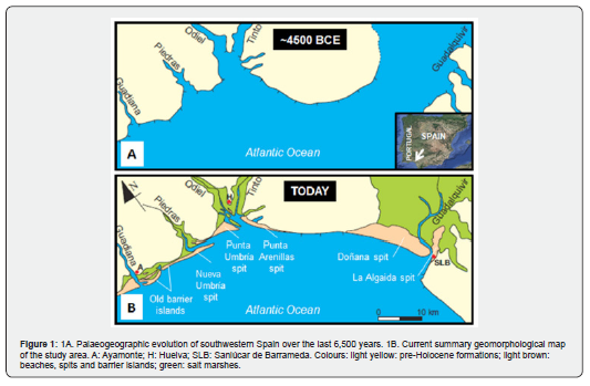
The southwestern coastline of the Iberian Peninsula between the Guadiana and Guadalquivir rivers consists of four estuaries (Guadiana, Piedras, Tinto-Odiel and Guadalquivir) that are currently heavily silted up due to the presence of sandy spits whose growth has caused large areas of marshland to grow inland. This silting process began around 5,000-4,500 BCE, when the sea flooded these estuaries during the Holocene transgressive maximum [1]. At that time, this coastline consisted of cliffs made up of pre-Holocene formations (Figure 1A).
Subsequently, the growth of these coastal spits developed in four spit systems (H1: 4900-2500 BCE; H2: 2200-600 BCE; H3: 300 BCE-900 CE; H4: 1000 CE to the present) divided by erosional phases at 2500–2200 BCE, 600–300 BCE and 900-10003CE [2]. They have played a very significant role in the distribution of settlements of the peoples who have inhabited this area over the last few thousand years (Figure 1B).
The Tartessian civilisation developed in the southwest of the Iberian Peninsula between the 9th century BCE and the 6th century BCE. Although there are no written sources about this civilisation, various Greek and Latin historians, such as Herodotus (5th century BCE), Strabo (1st century BCE-1st century CE) or Avieno (4th century CE) make reference to Tartesso [3]. The Tartessians were renowned for mining and trading minerals (especially copper, silver, and gold from the Iberian Pyrite Belt), which they exchanged with other Mediterranean peoples, such as the Phoenicians, with whom they maintained close ties through the establishment of various fishing factories and ports on the southwestern Iberian coast.
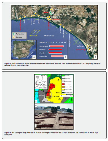
The Roman conquest of the Iberian Peninsula began in 218 BCE and ended in 19 BCE during the reign of Emperor Augustus. In 27 BCE, he divided this territory into three provinces: Tarraconensis, Lusitania and Baetica. Baetica was bounded on the west and north by the Guadiana River, extended eastwards through the Guadalquivir River Depression and the western part of the Baetic mountain ranges, and its southern boundaries were the current Atlantic and Mediterranean coasts of Spain. On the western Atlantic coast, one of the main economic activities was fishing, whose products were manufactured in a series of factories (‘cetariae’) located between the Guadiana and Guadalquivir rivers (Figure 2B-C).
This study analyses, from a geological perspective, the situation of a Tartessian settlement and three Roman factories. Its aim is to carry out a palaeogeographical reconstruction of these four historical sites, as well as to examine the factors that led to their establishment and the reasons for their abandonment.
A Tartessian necropolis on a hill: La Joya (city of Huelva)
A substantial part of the city of Huelva is located on several hills (locally called cabezos) consisting of a series of geological formations and units that were deposited from Neogene marine environments to Pleistocene river basins (Figure 3A). In chronological order, these are as follows: i) Gibraleón Clay Formation (Tortonian-Messinian) [4], composed of blue silts and clays deposited in bathyal to circalittoral environments [5,6], (González-Regalado and Ruiz, 1990; González-Regalado and Ruiz, 1991); ii) Huelva Sand Formation (Lower Pliocene) [4], formed by basal glauconitic silts followed by alternating bioclastic levels and highly bioturbated sandy silts typical of infralittoral environments; iii) Bonares Sand Formation (Upper Pliocene-Pleistocene) [7], with finely grained, highly bioturbated sands at the base and more abundant conglomeratic levels towards the top; and iv) Unit Conquero, dominated by river terraces. The remaining surface area of this city consists of historical and recent landfills on Holocene marshes.
The Tartessian necropolis of La Joya is located on the hill of the same name, with a maximum height of 54 metres (Figure 3A). This hill, together with other six adjacent hills, formed part of the cliffs that surrounded the estuary of the Tinto and Odiel rivers during the Holocene transgression maximum (Figure 1A). It is undoubtedly one of the most important archaeological sites of a funerary nature in the protohistory of the Iberian Peninsula, where two unique and paradigmatic examples of the so-called Tartessian princely tombs (Figure 3B) have been documented, which also contain one of the richest grave goods from the Orientalising period to have been found on the Iberian Peninsula.
Most of the tombs are cremation tombs, in which the ashes were placed in globular ceramic urns with a modest set of grave goods consisting of red slipware plates and handmade bowls. The richest and most unique grave goods are found in the four tombs known as ‘princely’ (Tombs 5, 9, 17 and 18), due to the supposed importance of the individuals buried there, probably the most distinguished members of Tartessian society in Huelva.
Consequently, these tombs were excavated in an elevated area of the city, beyond the reach of the tides and winter storms that have battered this area since the Holocene [8]. Likewise, there is geological evidence of tsunamis during the end of the Tartessian period (6th century BCE), which would not have affected this burial site due to its height above sea level [9].
Roman settlements
The Roman burial site and anchorage of the Isla-Canela-Punta del Moral barrier island
During the Holocene transgressive maximum, the coastline near the Spanish-Portuguese border consisted of cliffs formed by Paleozoic shales and greywackes and Triassic basalts and volcanoclastic rocks (Figure 4A). About 3,000 CE there was a drop in sea level of about 1.5-2 m [10] and the joint action of the eastward coastal drift currents and the Guadiana River's contributions caused the emersion of a group of sandy barrier islands in the northern part of the estuary [11]. Pinillo Island (Figure 4B) was one of them and currently rises about 2 m above the adjacent marsh. Lithic workshops, quartzite and silex carving debris and ceramic remains dated between 3,000 BCE and 2,000 BCE have been found there [12], indicating that it was already consistently above tide level.
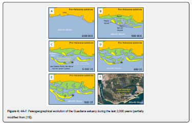
Over the following thousands of years, new sandy barrier islands emerged, as well as various marshy areas in between and attached to the coastal cliffs (Figure 4C-E). These islands are mainly formed by dune systems, such as that of Isla Canela-Punta del Moral, which has been the subject of numerous archaeological surveys for almost four centuries [13]. In the last fifty years, the ceramic elements obtained in this area have shown that this dune system was already consolidated in the 1st century CE [14].
Subsequent archaeological investigations also revealed: i) a Roman anchorage, with important activity until the 6th century CE [16,17]; ii) a circular funerary monument (2nd-4th centuries CE); ii) the presence of several tombs dating from the late 3rd to the early 4th century CE, one of them with a floor of shells of symbolic cult character; iv) the existence of a Roman mausoleum from the 4th century CE within an area of cremations and ritual deposits delimited by walled constructions; and v) a Roman salted fish factory. Consequently, this barrier island system emerged more than 2,000 years ago and caused the Guadiana River to flow into the Atlantic Ocean through two branches, one directly to the south and the other parallel to the coast and located between the coast and these islands, as recorded by the Roman chroniclers Strabo and Ptolemy [18].
The chronology of these structures is closely linked to the geomorphological evolution of the Guadiana River estuary. The Romans initially built the anchorage at the end of one of the islands that made up an early system of barrier islands close to the cliffs, in order to take advantage of the double mouth of the Guadiana River and have a base for their fisheries. Once the new barrier island of Isla Canela-Punta del Moral was consolidated, they proceeded to begin the construction of funerary structures, especially tombs. The third phase consisted of the construction of the mausoleum during the 4th century CE, in an area close to the inner edge of this new island to protect it from tides and high-energy events. The progressive silting up of this area, together with the fall of the Roman Empire, led to the decline of the anchorage and its abandonment in the 6th century CE.
Estuarine factories: El Eucaliptal and La Cascajera
The Roman factories of El Eucaliptal and La Cascajera are located in the estuary of the Tinto and Odiel rivers (Figure 5A-B). The Roman factory of El Eucaliptal was located on the inner side of the Punta Umbría spit. It was located above H2, so that two shells taken very close to this factory were dated between 1480 BCE and 1200 BCE, respectively [19]. Consequently, the dune substrate on which El Eucaliptal was established had already been emerged for at least 1200 years before its location and this site provided protection against the direct impact of waves and winter storms. On the other hand, it provided food resources from the estuary itself, such as brackish species.
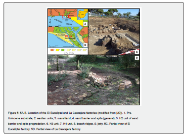
This factory was active between the 1st and 6th centuries CE, although the main periods of production or occupation were the first half of the 2nd century CE, the second half of the 3rd century CE, and the 4th-5th centuries CE. In this factory, the geomorphological evolution of the environment played an important role in changes in mollusc species catches. In the occupation levels of the 2nd century CE, the massive presence of shells from the bivalve Solen marginatus has been confirmed, a species typical of intertidal zones more commonly found on the beaches of south-western Spain. However, the progressive silting up of the estuary led to a change in strategy towards catching other species during the 4th and 5th centuries CE, such as the edible cockle Cerastoderma edule [20].
The Roman factory on the island of Saltés was located opposite El Eucaliptal, near the tidal channel of the Estero de los Muertos. This factory was located on the La Cascajera barrier, whose development began as a chenier around the 2nd-1st centuries BCE. Subsequently, the sedimentary sequence includes already emerged storm deposits dating from between the 1st century BCE and the 1st century CE, including two washover fans. However, it would be another 300 years before the La Cascajera factory was built on these bioclastic sediments, around the 4th century CE. By this time, new marshes had begun to emerge in the vicinity and a sandy tidal plain stretched south of this settlement [21,22]. This palaeogeography would explain the capture of species of the genus Glycymeris in these soft bottoms and the accumulation of their shells as a shell midden on the banks of the adjacent tidal channel [23], probably for the elaboration of mixed sauces of fish [24].
On dune ridges: Cerro del Trigo
The Roman factory at Cerro del Trigo is located in the inner part of the Doñana spit, about 3 km from the coast. This site was occupied from the 2nd century CE to the 6th century CE, a period in which the Doñana arrow was growing (H3: 300 BCE-900CE) and its final part was located near this settlement (Figure 6A). During this period, there is a scarcity of data in the 3rd century CE, a boom during the 4th century CE and part of the 5th century CE, followed by a decline that culminated in its abandonment during the 6th century CE [22]. These temporary booms are also reflected in the subfossil record, consisting of ungulates and the bivalve Glycymeris glycymeris [25].
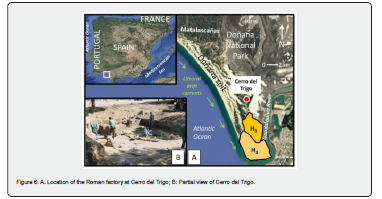
This location protected it from winter storms and even from the direct impact of a tsunami that occurred during the 3rd century CE, although the previous earthquake affected its structures and led to a temporary decline during the following century [26,27]. Subsenquently, the silting up of the marine channel near Cerro del Trigo, with the gradual emergence of marshes, contributed to its eventual abandonment, according to microfaunal data obtained from a nearby core [28].
Conclusion
A geomorphological analysis of the Spanish south-Atlantic coastline provides a powerful tool for explaining the location of historical sites, from their original setting through to their development and eventual abandonment. The palaeogeographic evolution of the coastline was key to historical decisions regarding the location of a Tartessian necropolis, situated on a high hill atop a cliff formed of compacted Neogene materials and well above the reach of tidal or storm surges. On the other hand, the Romans built salting factories (so-called ‘cetaria’) in areas relatively protected from coastal spits, always centuries after these had become established and with an opening close to the open sea. Their fishing activities adapted to the progressive silting up of the estuaries where they were situated, whilst tsunamis caused serious damage and even periods of abandonment at these sites.
Acknowledgement
The present study is part of the work carried out within the framework of the project “El arco atlántico del sudoeste hispano desde la protohistoria hasta la Tardoantiguedad: Evolución geomorfológica, ocupación litoral y sistemas portuarios” (Ref. PID2022-142778NB-I00) Proyectos Generación del conocimiento convocatoria 2022. Other funds have come from the University of Huelva (groups HUM-132, RNM-238, and RNM-293). It is a contribution to the Research Center in Historical, Cultural and Natural Heritage (CIPHCN) of the University of Huelva.
References
- Dabrio CJ, Zazo C, Lario J, Goy JL, Sierro FJ, et al. (1999) Sequence stratigraphy of Holocene incised-valley fills and coastal evolution in the Gulf of Cadiz (southern Spain). Geologie en Minjbow 77: 263-281.
- Zazo C, Goy JL, Somoza L, Dabrio CJ, Belloumini G, et al. (1994) Holocene Sequence of Sea-Level Fluctuations in Relation to Climatic Trends in the Atlantic-Mediterranean Linkage Coast. Journal of Coastal Research 10(4): 933-945.
- Cuervo B (2016) La civilización tarté Historia Digital 27: 98-135.
- Civis J, Sierro FJ, González-Delgado JA, Flores JA, Andrés I, et al. (1987) El Neógeno marino de la provincia de Huelva: antecedentes y definición de las unidades litoestratigráficas In: Jorge Civis (ed.), Paleontologia del Neogeno de Huelva: (W. cuenca del Guadalquivir). Salamanca: Universidad de Salamanca, pp. 9-21.
- González-Regalado ML, Ruiz F (1990) Los ostrácodos del tramo inferior de la Formación Arcillas de Gibraleón (Gibraleón, provincial de Huelva, S.W. España). Revista de la Sociedad Geológica de España 3: 23-31.
- González-Regalado ML, Ruiz F (1991) Significado paleoecológico y biostratigráfico de los ostrácodos del Neógeno Superior de la sección de Huelva. Revista Española de Paleontología 6: 107-116.
- Mayoral E, Pendón JG (1986/1987) Icnofacies y sedimentación en zona costera. Plioceno Superior (¿?), litoral de Huelva. Acta Geologica Hispanica 21-22: 507-513.
- Ruiz F, Borrego, J, López-González N, Abad M, González-Regalado ML, et al. (2008) The geological record of a mid-Holocene marine storm in southwestern Spain. Geobios 40(5): 689-699.
- Álvarez M (2022) Crisis y adaptación en la Huelva tartésica:el impacto de un evento de inundación extremo en la evolución constructiva y en la dinámica histórica del emporio onubense(siglo VI a.C.). In: Clara Toscano, Javier Bermejo and Juan Manuel Campos (eds.), Los orígenes del urbanismo. Oxfordshire: Archaeopress, pp. 257-274.
- Ojeda J (1989) La dinámica litoral reciente en la costa occidental de Andalucí AEQUA Monografías 1: 123-132.
- Morales JA (1997) Evolution and facies architecture of the mesotidal Guadiana River delta (S.W. Spain-Portugal). Marine Geology 138(1-2): 127-148.
- Gómez F, Castiñeira J, Campos JM, Borja F, García JM (1993) Prospección arqueológica superficial interfluvio Guadiana-Piedras. Anuario Arqueológico de Andalucía 1991: 239-246.
- Caro R (1634) Antigüedades y principado de la Ilustríssima Ciudad de Sevilla; y Chorographía de su convento jurídico, o antigua Chancilleria. Sevilla: Andrés Grande.
- Schubart H, Arteaga O, Hoffmann G, Kunst M (1990) Investigación geológicoarqueológica sobre la antigua línea de costa en Andalucí Campaña de 1988. Anuario Arqueológico de Andalucía/1988 II: 185-189.
- Morales JA, Garel E (2018) The Guadiana River Delta In: Juan Antonio Morales (ed.), The Spanish Coastal Systems, Springer International Publishing, pp. 565-581.
- Pérez Macias JA, González D, Rodríguez MJ (2013) El fondeadero romano de Isla del Moral y el comercio marítimo en la desembocadura del Guadiana. Espacio, Tiempo y Forma, Serie II, H.ª Antigua 26: 339-370.
- De Haro J, Cabaco B, García E (2017) Nuevos descubrimientos en el yacimiento romano de Isla Canela-Punta del Moral (Ayamonte, Huelva). XXI Jornadas de Historia de Ayamonte: 181-219.
- Ruiz Acevedo JM (2010) El suroeste peninsular en las fuentes grecolatinas: el territorio onubense. Huelva: Universidad de Huelva.
- Dabrio CJ, Zazo C, Goy JL, Sierro FJ, Borja F, et al. (2000) Depositional history of estuarine infill during the last postglacial transgression, Gulf of Cadiz, Southern Spain. Marine Geology 162(2-4): 381-404.
- Leyton LJ, Gómez G, Ruiz F, González-Regalado ML, Muñoz A, Rodríguez Vidal J, et al. (2026) Análisis sedimentológico y registro faunístico de la cetaria romana de El Eucaliptal (Punta Umbría, S.O. de España). Onoba Monografías 18: 217-237.
- Cáceres LM, Gómez P, González-Regalado ML, Clemente MJ, Rodríguez Vidal J, et al. (2018) Modelling the mid-late Holocene evolution of the Huelva Estuary and its human colonization, South-Western Spain. Marine Geology 406: 12-26.
- Campos JM, Rodríguez Vidal J, Bermejo J, González-Regalado ML, Abad M, et al. (2014) Nuevos estudios arqueológicos y geomorfológicos en el Paraje Natural de Marismas del Odiel: La barrera arenosa de la Cascajera. 1ª Jornadas Internacionales Marismas del Odiel: Reserva de la Biosfera, Huelva.
- Ruiz F, Gómez G, González-Regalado ML, Rodríguez Vidal J, Cáceres LM, et al. (2020) A multidisciplinary analysis of shell deposits from Saltés Island (SW Spain): The origin of a new Roman shell midden. Palaeogeography, Palaeoclimatology, Palaeoecology 538: 109416.
- Bermejo J, Campos JM, García Rincón JM, Vera JC (2016) Arqueología en el paraje natural de Marismas del Odiel (Huelva) y su entorno, desde la prehistoria hasta época tardoantigua. In: Juan Manuel Campos (ed.), El Patrimonio Histórico y Cultural en el paraje natural Marismas del Odiel: Un enfoque diacrónico y transdisciplinar. Huelva: Universidad de Huelva, Puerto de Huelva, pp. 107-129.
- Bernáldez E, Bernáldez M (2002) Interpretación tafonómica y paleobiológica de las ruinas romanas del Cerro del Trigo en Doñana, Huelva. PH Boletín 40/41: 103-116.
- Schulten A (1972) Tartessos. Madrid: Espasa Calpe.
- Bermejo J, Ruiz F, Gómez G, Rodríguez Vidal J, Cáceres LM, et al. (2026) Registro geológico de eventos de alta energía y su interacción con la producción salazonera imperial romana: El Cerro del Trigo (Parque Nacional de Doñana, S.O. de España). Onoba Monografías 18: 239-250.
- Ruiz F, Abad M, Pozo M, Carretero MI, Rodríguez Vidal J, et al. (2013) Evolución paleoambiental del sector meridional del Parque Nacional de Doñana desde el Plioceno Inferior a la actualidad. Estudios Geológicos 69: 73-77.