At The Crossroads of Trade Routes. Pre-Teutonic Chełmno, Poland
Wojciech Chudziak1*, Marcin Weinkauf2 , Jacek Bojarski3 and Ryszard Kaźmierczak2
1Professor, Nicolaus Copernicus University in Toruń, Faculty of History, Institute of Archaeology, Poland
2Ph.D., Nicolaus Copernicus University in Toruń, Faculty of History, Institute of Archaeology, Poland
3DSc, Nicolaus Copernicus University in Toruń, Faculty of History, Institute of Archaeology, Poland
Submission:November 26, 2024; Published:December 05, 2024
*Corresponding author:Wojciech Chudziak, Nicolaus Copernicus University in Toruń, Faculty of History, Institute of Archaeology, ul. Szosa Bydgoska 44/48, 87–100 Toruń, Poland. E-Mail: wojchud@umk.pl
How to cite this article:Chudziak W, Weinkauf M, Bojarski J, Kaźmierczak R. At The Crossroads of Trade Routes. Pre-Teutonic Chełmno, Poland. Glob J Arch & Anthropol. 2024; 14(2): 555881.DOI: 10.19080/GJAA.2024.14.555881
Abstract
Archaeological investigations at Kałdus and its surroundings have yielded convincing new evidence of the historic stronghold of Chełmno, which was given to the Teutonic Order by a Piast duke, marking the beginning of the monastic state in Prussia.
Keywords:Poland; Western Slavic; Early Medieval; Chełmno Land; Settlement Complex
Introduction
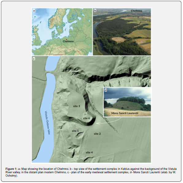
The Chełmno Land lies on the right bank of the Lower Vistula basin, in an area inhabited by West Slavs in the Early Middle Ages (Figure 1a-b). In 1228, this territory together with the hillfort in Chełmno on the Vistula was given to the Teutonic Order by Polish duke Konrad I of Masovia. Since 1996, the excavation works have been conducted by a multidisciplinary research team from the Institute of Archaeology at Nicolaus Copernicus University in Toruń [1]. The settlement complex surrounding the hill covers an area of 16 hectares and comprises the hillfort (Kałdus, sites 6, 3), a vast settlement outside the ramparts (Kałdus, site 2), and three cemeteries (Kałdus, sites 1, 2, 4) (Figure 1c-d). Also associated with the settlement complex in question is a settlement, a presumed harbour, located directly on the old riverbed of the Vistula (Starogród, site 6). As yet, a rich cultural stratigraphy has been recorded and several hundred settlement pits have been unearthed along, dated back from the turn of the 8th century to the 13th century, when this place was taken over by the Teutonic Knights. At present, a National Science Centre research project is being carried out with the purpose of revealing the supra-regional contacts of the inhabitants of Chełmno, which was situated at an important junction, specifically, at the intersection of major long-distance routes, namely, the waterway along the Vistula running from the Slavdom interior towards the Baltic Sea, and the land route leading from Pomerania towards Rus’.
The Spatial-Functional arrangement of the Settlement Complex
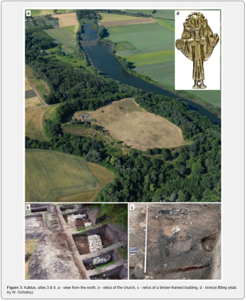
The biggest in the Chełmno Land and situated north of the Saint Lawrence Hill, the hillfort has cultural layers that in certain areas reach up to several metres deep. Owing to the excavation studies and the recent geomagnetic research (Figure 2), we do know that this area comprised three parts (Figure 3a), namely, the main hillfort with the moat (A); the lesser hillfort (B); and utility area (C). Within the outline of the former, several levels of wooden residential buildings were unearthed, first of wattle-post construction (second half of the 10th century, the turn of the 11th century), followed by structures of log construction (the turn of the 12th century (Figure 3b). West of this part of the hillfort, ruins of stone triple-apse church were unearthed, 35,4 m long and 17 m wide (Figure 3c). In the light of the most recent studies, it can be dated back to the second half of the 11th century. The church was chosen to be constructed in an exceptional place, as a stone pile was found there, older than the church itself, showing abundant evidence of pagan ritual activities from the second half of the 10th century (burnt material, ashes, a human skull, animal bones, thousands of cereal grains, thousands of black elderberry seeds, etc.). The adjacent area north of this zone shows magnetic anomalies indicative of relics of terraced houses. As yet, the northern part of the hillfort, which is likely a utility area (traces of black metallurgy, blast furnaces) as well as its eastern part have been explored at random, the latter comprising a well, which was assumedly the sole water source inside the hillfort.
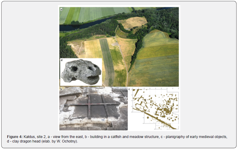
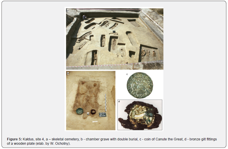
In turn, south of the Saint Lawrence Hill, remains of a vast settlement serving craft and trade purposes outside the city walls were revealed, as evidenced by numerous finds of production waste and tools typical of black and coloured metallurgy, as well as an assemblage of scales and trade weights (Figure 4). Within the settlement, an inventory was taken for remains of several hundreds of dwelling structures focused in a few places (houses, hearths, furnaces waste pits, etc.) (Figure 4c). These were diverse in terms of size, shape, and their original purpose, whereas their chronology was estimated at from AD 700 to AD 1250. The two foci of objects were originally enclosed by fences, which indicates that the settlement was arranged in the form of farmsteads. Most likely, a large building of vertical post-log construction with an arcade to the north was of particular importance, interpreted as remains of a 12th century inn (Figures 4b). In the immediate vicinity of the settlement, three foci of skeleton graves were encountered, totaling over 1000 burials dated back from 975 to 1225 (Figure 5a). In terms of form and size, most of them are characteristic of Christian eschatology [2]. The ones that stand out the most are elite chamber graves abundant in grave goods, related in terms of their nature to similar graves known especially from Denmark, dated back to the oldest horizon of the cemetery (Figure 5b). Genetic testing of these burials shows that they are likely linked to Northern Europe [3].


Artefacts that Evidence Supra-Regional Contacts
The social, political, and economical functions of the hillfort and the settlement identified so far indicate that this centre played the main role in the region and had relations with the Baltic area and Rus’. The long-distance relations of Chełmno inhabitants are evidenced by numerous items imported from Scandinavia (runic artefacts, glass beads, semi-precious stone beads, and coins), Prussia (pins, adornments), Rus’ (a piece of a corchag amphora, silk fabrics, crosses, adornments, stone spindle whorls, Kiev-type Easter eggs, clay dragon head (Figure 3d), but also from West Europe (coins minted in Bavaria, Saxony, and England (Figure 4c), a sword from the Rhineland) and Central Europe (Bohemia, Hungary). Some of the coins of Arab origin were manufactured in the area of the caliphate (Arab dirhams). Many of the items are unique, such as a bronze plate depicting a female, most likely Scandinavian goddess Freya (Figure 2d). Another one-of-a-kind object is a wooden plate with gilded bronze fittings bearing the motif of the peridexion, probably from Byzantium (Figure 4d). One should also associate with the Saint Lawrence Hill the silver hoard unearthed nearby in Ujście, hidden after 973 with a significant share of West-European and Byzantian coins, albeit with the prevalence of Arab dirhams.


Conclusion
The recent archaeological studies in Kałdus have revealed a number of relics of the settlement space and artefacts that evidence the supra-regional role of this place in Early Middle Ages. There is much evidence to suggest that in the pre-state period the Saint Lawrence Hill was the main settlement hub in the Chełmno Land. As a result of the expansion, at the end of the 10th century, this area was annexed by the Piast State. Chełmno became the major administrative, social, economic, and cultural centre, the seat of the secular and Church authorities in this part of Slavdom, and, as a settlement complex, it fulfilled the criteria for an early city (urbs). Numerous artefacts of foreign origin and other premises such as elite chamber graves prove the existence of far-reaching supra-regional contacts between its residents and the multiple directions of the flow of humans, objects, and ideas. These contacts were taking place especially on the level of social elites that served various roles in the highly hierarchical society, including warriors/knights, the clergy, craftsmen, and merchants. Chełmno was also the key strategic centre in the so-called Prussian Crusade, starting from the mid-12th century until the arrival of the Teutonic Order, which began the conquest and Christianisation of Prussia.
Acknowledgements
The works are supported by the Faculty of History at Nicolaus Copernicus University in Toruń.
Funding Statement
The article was written within the framework of the project “Wczesnośredniowieczny zespół osadniczy w Kałdusie – chełmiński sedes regni principalis (projekt 5)”, funded by National Science Centre under the OPUS 23 competition (UMO- 2022/45/B/HS3/01572).
References
- Chudziak W (2010) Chełmno/Kulm: Genese und Funktion einer frühmittelalterlichen Stadt. Acta Praehistorica et Archaeologica 42: 19-40.
- Matczak MD, Chudziak W (2018) Medical therapeutics and the place of healing in early medieval Culmen in Poland. World Archaeology 50(3): 434-460.
- Płoszaj T, Jędrychowska-Dańska K, Zamerska A, Lewandowska M, Bojarski J, et al. (2020) Analysis of maternal lineage structure of individuals from chamber graves placed in medieval cemetery in Kałdus, Central Poland. HOMO 71(1): 43-50.


