Layouts of Tula: Landscape and Orientation
Héctor Patiño Rodríguez Malpica*
National School of Anthropology and History, Mexico City, Mexico
Submission: December 12, 2022; Published: February 01, 2023
*Corresponding author: Héctor Patiño Rodríguez Malpica, Professor of Subject B, National School of Anthropology and History, ENAH Periférico sur y Zapote, s/n, Isidro Favela, Alcaldía Tlalpan, CP 14030, Mexico City, Mexico
How to cite this article: Héctor Patiño Rodríguez Malpica*. Layouts of Tula: Landscape and Orientation. Glob J Arch & Anthropol. 2023; 12(5): 555849. DOI: 10.19080/GJAA.2023.12.555849
Abstract
The study of the layouts of urban nucleus of Tula Grande implied the internal coherence that corresponds with a “spatial structure”. This essay presents some factors that I consider important when located, oriented, and sizing the monumental zone of this ancient city. It is necessary evaluate whether this conception was applied considering the interaction between the effect of latitude and the various longitudes, seek to cosmography like a form of knowledge that I can attribute to Mesoamerican Antiquity. In particular abstracted the spatial structure when complete the record of the 5 indicated dates, detecting the zenithal-nadiral axes, and delimited by the norm of maximums of solstices. With these dates of the temporal equinoctial axes and those of the 52-day time interval obtain the angular difference of 15° east of north. We verified that this game of temporal intervals of 27 and 32 days that was characteristic of the place was what finally allowed to this urban nucleus of Tula Grande to acquire its final shape and real dimension.
Keywords: Territory appropriation; Spatial structures; Latitude; Canonical dates; Interval temporal
Introduction
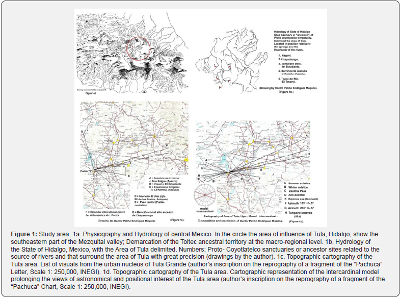
Between 2012 and 2015 carried out Archaeoastronomical observation in the urban center of Tula Grande, in the extreme southwest of the State of Hidalgo, Mexico (Figures 1a & 1b). This investigation has realize in coordination with Hans Martz who undertaken the precise or exact measurement of this urban nucleus. We documented temporary events linked to the study of the horizon calendar of the ancient Toltec capital. However, this work is still preliminary. I needed reviews the documentation for obtaining some result from its factual analysis. However, this task is relevant to interpret the way they had to lay out the monumental space of Tula Grande in correspondence with the horizon calendar.
This study can be considered an advance in temporal terms. But the development of the research must include both perspectives: space-temporal. The ancient landscape of Tula implies the knowledge about the “spatial structure” what we can take of the Ethnohistory (Figure 2c) [1]. This structure presented here follows this model intercardinal (Figure 2a, below). It takes the form center-periphery and moved to the center located in the urban nucleus of Tula Grande and corresponding with directions where are immersed in the horizon to lie the different sanctuaries or “ancestor” sites that we can consider of Proto-Coyotlatelco tradition. Although not all positions were accurately documented, the marks of canonical dates and time intervals correspond relatively to each milestone on the horizon (Figures 1b & 2b).
The early appropriation of Tula territory implicates that this people making the proclamation in some senses. First, they had in mind the Tlalocan patrimony that the Teotihuacan city left free during its fall. Second, a growing community necessarily establishes the control of water and land in this territory. Third, they saw the transit of the celestial bodies, and pointing the marks of the solar transit in each horizon. And, forth, I consider that the “latitude effect” participates in the process of benefiting from radiation and sunlight (infra)1. The study of these factors involved the configuration of the urban nucleus of Tula Grande, search to understand the internal coherence that corresponds with these “spatial structure2” [2,3].
This essay presents some factors that I consider important when located, oriented, and sizing the urban nucleus of Tula Grande (Figure 3-6). It is also interesting to evaluate whether this conception was applied considering the interaction between the effect of latitude and the various longitudes [4,5]. That is, seek to cosmography like a form of knowledge that I can acknowledgment for the Mesoamerican Antiquity.
1It is now a certainty that every ancient city in Mesoamerica, for example, the ancient Mayan “City-State”, competed and toiled in that appropriation of heat and sunlight. Indeed, its design and line was dedicated to the appropriation of the hierophany, which, in turn, implied the possibility of benefiting from the energy provided by the Sun. I refer here to the knowledge that intervened to fulfill what we will call the “real-ritual” task. Cfr. Fox G. Richard (1977) Urban Anthropology. Cities in their Cultural Settings. Prentice-Hall, New Jersey, pp. 39-43. I consider the ambient of that ancient relationship between the sanctuaries or “ancestor” sites and the urban nucleus of Tula Grande and turns it into the nerve center or “political heart” in the constitution of that broad social space. I pondering that was a question that occurred under the form “Royal-ritual”, that is, for an aristocracy that had this vocation for geographical, cosmographic, astronomical knowledge. The detected procedure, it should be noted, have acted for the general benefit, but it was manipulated by the government leadership; from this reflection it follows that an error in the dome could be very negative, perhaps for this reason, Tula Chico was abandoned since its quasi north-south orientation did not correspond to latitude, so that the entry of sunlight was sufficient to illuminate and/or heat a space for as long as possible, etc. It is necessary to distinguish this from the solar hierophany, which would be a form of developed appropriation that implies the cosmographic instrumental management of the entry of full sunlight into a closed area on certain days of the year and the rest entering partially, or not entering so full, etc [10] [(Vid ., Patiño, 2017: Figure 6.6.29 a)].
Methodology
The study of the horizon calendar at the urban nucleus of Tula Grande required a combination of methods and the subsequent discussion of the results obtained. In this task is which we present some previous advances [6]. We have a first method of approximation, which gave information that was basically qualitative. This contributing to describe in a preliminary sense those tasks of approach to Archaeo-astronomical observation previously realize in the ancient city of Tula [7]. Involve the study and elaboration of the drawing of each horizon profile (Figures 5a,b & 7b). This approach takes like guide the ethnographic work of Rafael Girard [8] on the spatial-temporal concept of the Mayan Chortí community. It’s linking through knowledge of the environment, work of the milpa, the mantic and ritual activity. In the Chortí tradition, the observer stays in the “navel” or center of the world, and lives a moment of responsibility. This implies the regulation of request for corn and its reproduction arises throughout the tropical year, with the offering to ask for rain and the celebration to thank for good harvests.
2Our previous description of the ancient landscape of Tula oscillates between what I first called “Sacred Geography” and later “Ritual Landscape” [(Vid. Patiño, s/f a-b)]; was frankly provisional and exploratory. Although at that time I had an erroneous perspective on the information and image available, it allowed us to have an initial perspective on a territory that for many years was transforming. We have some sources of Ethnohistory and ancient and historical ethnography applied to the Tula area to reinterpret the vocation that this ancient landscape had, focused, above all, on describing the agricultural cycle and ritual.
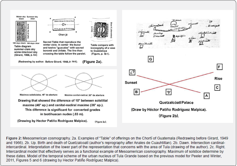
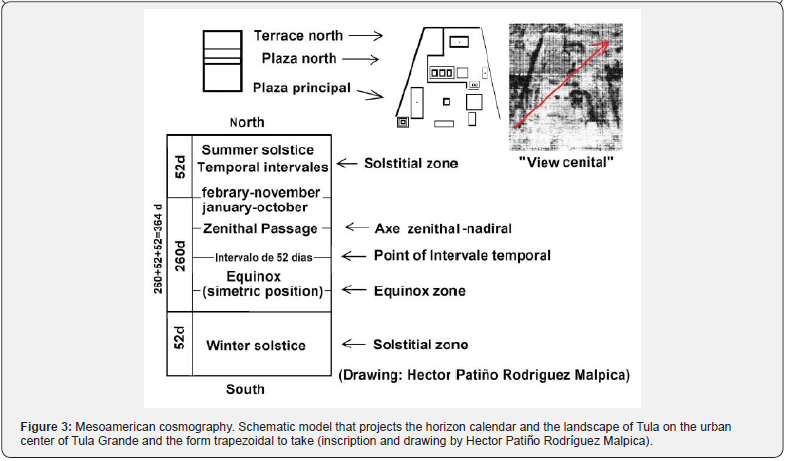
Girard [9], points out that among the Chortís the “Table” of offerings is a small-scale version of the cosmos (Figure 2a). It´s reflects the location specific of the intercardinal points and center that’s give the order that territory require. This corresponds with cosmogony and theology of Chortís. But, for cosmography, we see that it works from the concept of “half” or “halves” on the ground and the determination of latitude with parallel axes and with the study of the course of the Sun. That is, the author points out, the axis of the temporal equinox does not work so much, but rather the zenithal-nadiral axis (Figure 3); and I consider that this factor was the key to determine the orientation like a whole.
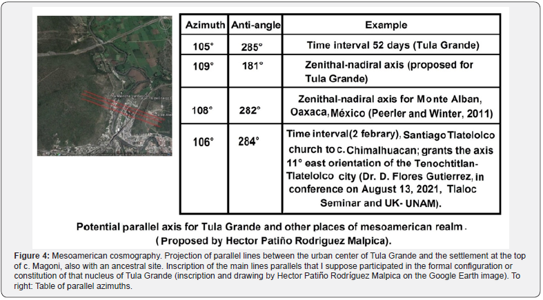
As a second method, we applied the “instrumental” hypothesis to carry out an archaeoastronomical measurement that would allow us to abstract the horizon calendar of that place. Later, I return over this method. A third method consists of the most elementary geometric inscription, especially of the points, the angles and the lines of visual correspondence, which can become axes of geometric work [10]. Essays that were made on cartography and topography resulted in the game of figures that I present here (Figures 3, 4 and 7). Pointing out, like common factor, that the angle of 15° east from north which also governs the inscription of those related elements. Each approximation is completed by a fourth method of a documentary nature that involves geographic, historical, ethno historical, ethnographic, and archaeological information [11-13]. In addition, I consider the particular methods that require the investigation of each matter3.
The observation and documentary exercise carried out as the second technical method, to embrace of the exact measurement with theodolite and compass of an important series of points and positions. Among which we have the centers and axes of symmetry of the main buildings of the urban nucleus of Tula Grande, and will be point out the resources that this ancient inhabitants had useful to axes derivate of visual observation on dates of temporal significance that pass over or in a parallel direction to the walls.
This methodological articulation gave meaning to the hypothesis about the harmony of parts. And we can assume, interceded in the configuration of the urban nucleus of Tula Grande. Following Tichy [14], we seek to establish: 1) the days in the middle of the year, 2) the dates of February and November that go to the east and those of May and August to the west; 3) to evaluate when “...the zenith, its double mark... reaches declination... [and]...coincides with the geographical latitude of the locality…”; and 4) the location of the cycle of regular structure of that arrangement dependent on the course of the sun on five astronomically determined days: solstices, two zenithal positions and two equinoctial positions, varying the groups of days depending on these latitudes (15°, 18°, 19° and 20.5°, “high center” period). In this sense, enters in position to abstract the “... reciprocal correspondence of space time, in the varied but planned ordering of time, in the structuring and orientation of large and small places of worship...” [14]. At this point, it is worth adding two other criteria pointed out by Franz Tichy [4]: the “effects” of latitude and longitude.
The first requires being consistent in obtaining those points reiterated previously, and for this we rely on instrumental hypotheses. In the case of the second criterion, it deals with the study of distances and measurement units. Issue will be treated only in form relative for this essay. The result is that now we can describe and determine the spatial marks documented with respect to the linear relationships that specifically had to do with the configuration of the nucleus of Tula Grande. The register of these azimuths made possible establish the identity between the places and their lines of projection towards to the mountain forms (Figures 2a,b & 7a,b). About develop of this spatial-temporal scheme, it was possible marking these spatial lines in each horizon profile as every temporal event was recorded for the Tula Grande horizon calendar (Figures 3, & 7 a & b). The factual information generated made it possible to establish the precise order of the groups of days that mark this set of events derivate of the scheme temporal [15].
This temporal scheme was the key which I have projected in the spatial sense with the visuals of the winter and summer solstices-that gives us the full scope from each flank of the site (Figure 3). The axis of the line of sight that I called “zenithal shot” is marked by the azimuth observed and recorded on the days of Zenith Passage. And the axis of the temporal interval of 52 days with its “anti-angle”, in correspondence with the marks of the temporal equinox and the temporary intervals of 27 and 32 days typical of the place [15]. These angles delimit the southern part of the place (Figures 3 and 4). The importance of the study of each azimuth is that it would be susceptible to become visual or axis of design and trace. I considering that in the past they would be taken as the main criteria to carry out the “architectural arrangement” [16,17]. It is probable that they were took them into account when giving orientation, dimension and particular shape to urban center of Tula Grande (Figures 2a-b, 6 & 7b).
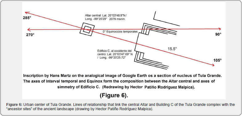
The spatial-temporal significance that this ancient landscape preserves reveals the scope of the articulation of criteria that would allow us a previous representation resulted in a series of images (Figure 7 a & b). Our hypothesis is that its detection was aimed at coordinating the set of alignments that make up this monumental complex (Figure 3). In theory the azimuths of each identified canonical date and said dates of the temporal intervals, joined with their corresponding opposite azimuth or “anti-angle”, form visual axes of almost 180° (Figure 7 a& b). These dates coincide with that intercalation of east-west horizons described by Franz Tichy [18]. I think what, extracting the formal or structural criteria that coordinated the construction of the monumental complex of Tula Grande, it was possible to form a scheme with the linear elements intervened to achieve that ordering, design and layout of the complex (Figure 7 b). Then, they have established this punctual relationship between the azimuths of the equinoctial axis and that of the Pan-Mesoamerican temporal interval (Figures 2b & 6). Detecting this angular relationship is what opens the possibility of interpreting these “structure spatial” as a previously preconceived form (infra).
3Regarding this ethnography of the area of Tula, Hidalgo, it was necessary to join or tie those matters that Broda (2004) points out about that ancient history and ethnography of the place that is studied (Cfr. Hector Patiño Rodríguez Malpica, “Etnografía y agricultura en el área de Tula Xicocotitlán.” In preparation. With this information, initially disjointed, it was possible to form a chorographic table on the sowing and harvest dates, and also to match said information with the general and patron saint festivals, hoping to abstract, if possible, the numerological-calendrical relationship that could have involved all that information.
The Toltecs of Tula perpetuated this relationship with their ancestors to entail the sanctuaries of the Proto-Coyotlatelco tradition. While the count of days allowed them to coordinate the times of the agricultural, planting and harvest cycles, which gave rise to establishing the ritual cycle that finally it would be instituted as a “ritual landscape”. However, it is still waiting to know if this “spatial structure” was configured in a commensurate sense for astronomical-calendar numbers or on mantic sense to organize the cycles of planting/harvest, or the cycles’ ritual and festive4.
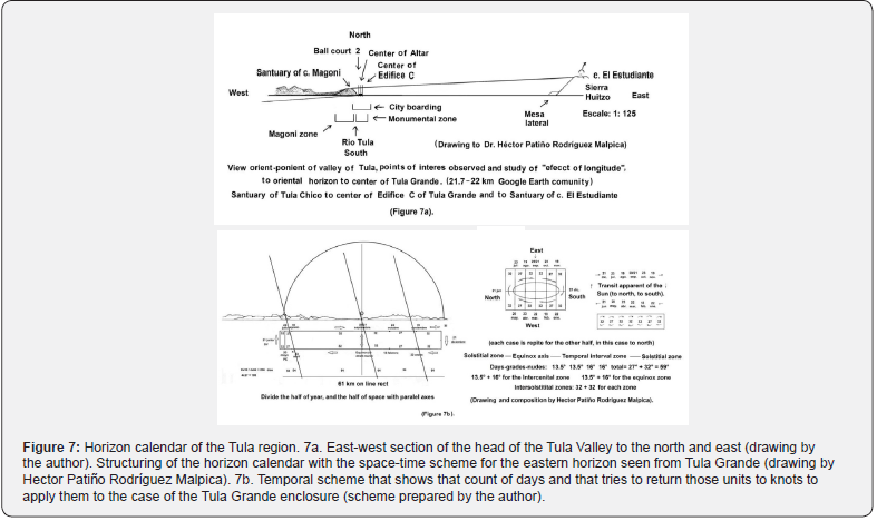
Even is necessary inferring the different scales for the study of each horizon that we contemplate from the monumental nucleus of Tula Grande (Figures 7a & b). Previously, I worked experimentally on some of its scales and their possibilities [19,20], and try to reach the compatibility necessary that implies adjusting the count of days to the size of the Tula Grande complex. That is, turn temporal units into spatial units of greater or lesser length (Figures 7a & b). However, this work rest in process of elaboration and revision5.
Indigenous Cosmography
I think in this knowledge that intervenes but we can need probe that it is of a cosmographic nature. Whether to identity or functional, the study of this relationship implies considering its nature. In this section, I make a reflection on the way in which the visuals stretch out to the landscape and with the orientation of a place. In first place, I think in the meaning of the intersection of cardinal and intercardinal models. It is precisely about those two perspectives to deal this essay. The first corresponds to a configuration that presents an interval zenithal-temporal ordering; and when combines the cardinal orientation shape with the intercardinal shape, and this results (Figure 4). Whit respect to implies a Mesoamerican cosmography (Figure 3), it is worth asking if the ancient Mesoamericans experienced this intersecting of models. Ultimately, it is a primary way they had to orient themselves. Involving knowledge of the horizon calendar and continuing with knowledge of the cardinal orientation.
4It is then necessary to establish the relationship between the small planting and the large planting/small harvest-large harvest. The interrelationship of the irrigation cycle offered by the first fruits and the seasonal cycle is a necessary background for Tula area to describe the festive and ritual calendar, the precise moment to ask for cultivation, sowing and harvest, etc. But it is not so easy to describe and study a territory whose vocation was fundamentally agricultural (Patiño, s/f, in preparation). The foregoing hardly offers a working guide, since the dates implying the arrival of the first rains and the moment when the rainy season begins, etc.
5It is worth studying this arrangement of the urban center of Tula Grande considering the whole and the parts in relation to the changes of scale that can go from the largest to the medium and, from there, to the small, etc. The spatial factor requires resolving the problem of the scale(s) that they should have used to undertake the domain of the territory starting with that cartographic sense implied in this essay as an “intersection of models”; it is necessary to focus in the first place on the cartographic and ideographic representation that emanates from it, and inform oneself to analyze and specify, in turn, the horizon profiles.
I think that the Tlamatinime of ancient nucleus of Tula Grande had about different possibilities of orientation expressed in that regional geography (Figures 2a & 2b). For example, the relationship where there is a great longitude for the eastern horizon and a close proximity to the western horizon (Figure 7a). In this case, view from a distance, could be complementary (Figure 7b).
The ancient landscape of Tula shows that the intercardinal model dominates at this a spatial structure. For this essay, it was possible to review the cartography previously prepared by the author on the landscape and ancient geography of Tula (Patiño, s/f a-b) [21,22], corrected and completed for this presentation (Figures 2a & 2b). This cartography reflects a “spatial structure” with the main capital as its center, while the Proto-Coyotlatelco ancestor sanctuaries on the hilly eminences that circumscribed and dominated the region (Figure 1a & 1b).
If the intercardinal model prevails to understand the ancient territory of the Toltec society, this significance increased with the determination of the astronomical or true north by the observation of the circumpolar stars that indicate and have indicated this important course for cultures6. The importance of the cardinal case is clear since it allows working the length in those directions.
Above all, with the inscription of the perpendicular northsouth axis imposed on the temporal interval axis, they were able to coordinate the whole architectural “accommodation” with the east- west arrangement to distribute the alignments according to their functions and dimensions (Figures 2a, 2b & 7a).
Latitude effect
It is now important consider the manner to that this record of the azimuthal angles given dates with calendrical-temporal significance. It must coincide with the visuals or lines of identity between the urban nucleus of Tula Grande and those “ancestor” places to a distance. And it is clear that this would have an impact on the management of space. Nevertheless, was possible verify that these azimuths functioned as relationship lines and, in turn, as composition axes. But the study of this relationship presents some previous questions lacking to resolve. In particular, obey with the documentation and positioning of the space marks corresponding to those “5 astronomically determined days”. Was necessary check if these dates of the temporal intervals were previously registered by the people of Tula Grande (Figures 3 & 7b). Then I assume that the procedure of dividing and orienting the space from the pan- Mesoamerican temporal interval formed a basis for configuring the built space of Toltec tradition (Figures 3 & 7a,b).
6Over the cardinal model specifically, it is necessary to reflect on the knowledge that the Mesoamericans had about a “cosmography of the north”, which is part substantial of our ontology. For example, it implies considering and making transitive those possibilities indicated by Terrazas (1981: Figures 33 and 34), for the ancient Maya; in his study of the ancient Mayan geometry, the author wonders about the three “norths” that we use in our contemporary world: the Astronomical or true North, the Magnetic North and the Grid North. Perhaps the north of the grid was preferred, and it is interesting to speculate about the use of the grid to coordinate those turns and the different “Norths”. It should be noted that in the ancient Mesoamerican drawing it possibly commanded the “grid north”, and that it was clearly related to the projection of those zenithal, equinoctial axes and the temporal interval for that point of observation; there are some reasons to suppose that these “cosmography of the north” joint work.
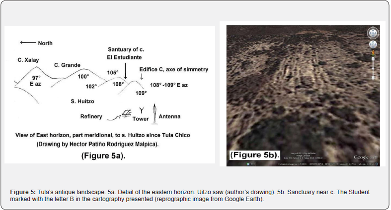
According to what we studied in the urban nucleus of Tula Grande, the “latitude effect” considers this deviation 15.5° east of the north to carry out an adequate appropriation of radiation and sunlight and fulfill that fundamental purpose. This effect requires awareness of the phenomenon of the Zenithal Passage and as a result grants the management of the zenithal-nadiral axis (Figure 3, up right). That is, on the one hand, seems to coincide with the visual toward the ancestral site associated with c. El Estudiante –but it remains to verify this round visual trip (Figure 5). On the other hand, it implies that the visual towards the c. Los Frailes in the day of Zenithal Pass is worth for considering whether they did so by asking with interest about that “latitude effect” (Figure 3)7. We observe, in this particular case of the ancient landscape of Tula the triangle marked out by point “0”, and the figure formed with the points B and F of our cartography (Figures 2a &b).
Then, that the appropriation of radiation and sunlight implies one properly management that indicated effect, and that it is expressed in the use of the temporal interval of 52 days or pan- Mesoamerican which we saw interacts with the axis of the temporal equinox. It has been registered as the main east-west axis for the urban nucleus of Tula Grande (Figures 6 & 7a). Thus, we can see that studying of this “latitude effect” can help to understand the phenomenon of land grabbing, and to have radiation and sunlight. As in other places, it is possible to assume that this is how the aforementioned “spatial structure” must have been linked to the urban nucleus of Tula Grande, with the central Altar as the center of all the ceremonial built space (Figure 6). Based on the observation of the solar transit, they sought to establish the relationship between that center or fixed point and the “ancestor” sanctuaries related, in turn, with each milestone or eminence (Figures 2a-b, 5 & 7a).
In this sense, the ancient cosmography implied carrying out a series of actions necessary to ensure the appropriation and claim of a territory. That tradition indicates that on these set of four cardinal directions from a high place –perhaps standing in the sanctuary in c. Magoni, shooting 4 arrows, one for each course, but we do not know if to make in cardinal or intercardinal direction. It is understood that they were able to delimit that space (Figure 2a-b). Of course, it is something that stands out in the ritual sense because any place would be cause for periodic celebration8.
The study of that identity between ancestor places and the alignments of the main buildings shows the link with the eminences of the mountains in that intercardinal sense. It only showed the cultural value of the link that relates the main settlement with the “ancestor” sanctuaries that were located on the eminences or hills that rise near the headwaters of the rivers (Figures 1a-b, & 2a-b, letters B & G).
7In other ancient cultures they have studied the relationship between the points and the angles formed by those lines that were worked in terms of distance. Similar to the Ancient Greek way of measuring one of its legs knowing the angle, its opening, and the distance of the other leg, the one on the short side, etc. ( Cfr ., Fernando J. Ballesteros, Measuring heaven and earth . Great ideas of mathematics, Slovenia, 2019).
8Complementary to the above would be the Chichimec custom reported in the Annals of Cuauhtitlan and the Xolotl Codex of shooting arrows towards the four directions or ends of the world. Although we do not know if they did it in a cardinal or intercardinal way, it was the archaic way they had to organize that perception of the territory as a knowledge that began in a parallel form to the previous Teotihuacan.
I question if it is necessary verifying the importance of each point that was located on these eminences (Figures 1b, & 2a-b). The set of sites corresponds to the limits offered by the “intercardinal” model. It proves that they knew the role played by these parallel axes of the particular time intervals of each place from the morphological point of view as a manner to handle that “latitude effect” (Figures 2 a-b, 6 & 7 a-b).
Ancestor Shrines
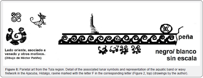
Among the sanctuaries or “ancestor” sites, it is worth noting two relationships of identity. The first between the points indicated on the topographic map: “0” and F, and point G, establishes a link of origin with the Chapantongo sanctuary. A possibly central place of the ancient Proto-Coyotlatelco tradition (Figure 2a, letter F, and 2b, letter G, and 6, red line). The second is the outstanding relationship between points “0”, B and F, and C of the topographic map , as they run with the meridian and the parallel (Figures 1b & 2a-b). The letter C groups a conglomerate of places that form the sanctuary of Ajacuba, I present one imagen of Parietal art (Figure 8).
It is what I have tried to represent when positioning them in the cartography. But, I insist, very few have been studied (Figure 5 a-b)9. With the Google Earth community program, I located some of those sites called “ancestor” that I attributed to the proto-Coyotlatelco culture that it is possible to identify with the Toltec-Chichimec tradition. It insists is necessary to explore and document those “ancestor” sanctuaries that, for the most part, need to be specified and described in detail (Figures 5a-b). Although we know little about them, it will be necessary to start with their temporality from the study of the stratigraphy and paleo-topography of the hill on which each were located.
I observed a link between the main buildings of the monumental complex of Tula Grande and the “ancestor” sites in the surrounding territory. It reveals that they applied a series of conditions that had to be met to make each foundation effective or functional. For example, the platform excavated in Chapantongo [23], its corners pointing in that zenithal-solstice direction (22°- 25° east). At the margin of the summer solstice the angle indicates an opening of separated 3° north- northeast. In the configured the zone of solstice (Figure 3 c), is relative the distance between one or two days of difference register of the solar transit. Perhaps they struggled to reduce this difference to one day, which requires the horizon calendar account.
It is relevant that most of these Proto-Coyotlatelco sanctuaries were located both on the tops of the hills, some not very high. But their dominate position offer a wide territorial vision (Figure 2 c & 7 a). I observed preference for elevations that were previously unoccupied and sought to be close to springs and downspouts. If the above is true, it is to be expected that they made offerings placed on the banks of those springs or at the headwaters of the rivers. Learning the ritual that is supposed to have been carried out in each sanctuary must have left abundant evidence. These places of veneration and adoration were the oldest in the valley10.
The foregoing suggests that this intercardinal orientation system operate in function to a principle of that ancient cosmology (Figure 1 b & 3 a-c). However, it does not tell us how the cardinal orientation intervened, and in general is what we understood as cosmography [24]. It is important to consider the different forms of cardinal orientation that we have. But in this reflection merge the weight of the intercardinal model. Which converges on the reflection makes that the nadiral- zenithal example of Monte Alban and the structures involved [5]. Besides what this “latitude effect” consists, the zenithal-nadiral relationship informs about the “size” or scalar gradation of ancient cosmography, which we also see reflected in our cartography (Figure 2 a-c & 3). Here is not possible to deal with this theme in depth. I previously took up one reliable example to show the way of operating this Mesoamerican cosmography (Figure 1 b & 3 b-c). While the city as the center surrounded by a “ritual” landscape identified as ancestral. This is participated and still participles of this archaic form [25].
On the differences and similarities that the ancient landscape of Tula has with respect to other communities -e. g., the basin of Mexico explores by Johana Broda [26,27]11. The proximity to the “ancestor” sanctuaries of Proto-Coyotlatelco tradition is given in relation to hydrology - particularly the springs and the headwaters of the rivers (Figure 1a-b). Then, must have been important the relationship of identity with these “ancestor” sites that dominated the southern half of the eastern horizon, with the site near the summit of c. El Estudiante and the western horizon with the predominance of c. Magoni (Figures 2 a-b, letter B, 5 b & 7 a).
9In the case of the urban nucleus of Tula Grande, the series of temporary tables generate previously, given by buildings and period, allow extending that information to determine three periods of development [10] . In particular, the essay focused on the second period. The important thing is that the reflection on each cultural change starts from the state in which the original paleo-soil was found and which was altered to be occupied by the first settlements towards the Sinana phase. (Fournier and Vigliani, 2005:25-26); the La Mesa Phase, Mastache, Alba Guadalupe, Robert H. Cobean, Charles Rees y Donald Jackson (1990) Las industrias líticas en el área de Tula. Col. Científica n°221, INAH-SEP, México); and of course, the Phase Prado of Tula Chico. Mastache, Alba Guadalupe, Robert H Cobean & Dan M Healan (2002) Ancient Tollan. Tula and the Toltec Heartland. University Press of Colorado, Colorado. Which altered that same paleo-soil characteristic of the sub-region [10]. In particular, it has been found that Tula Chico has a layer of sand at the bottom, although it seems sporadic, it is on the outcrops of sandstone with limestone extrusions in addition to the caliche crust that forms on top between each wet and then dry period. etc. (Patiño, s/f a); however, elsewhere the paleo-soil substratum consists of a lithic phase Pheoazem soil with a light substratum of hardened dark silt.
10This apart from Teotihuacan, that neither has been studied well in the sub-region. It is possible that the Proto-coyotlatelco culture at the beginning of this proclamation for the territory implanted its religious pantheon. Recovering contents from the Teotihuacan tradition or even older, just as the conception that preceded them. It should be considered that since ancient times it already recognized the Lord of the storms and also it made up the axis of the cult of Tlaloc: to the water, the earth-the hills and the crops. Cfr. Nichols L. Deborah, Charles D. Frederick, Luis Morret Alatorre y Fernando Sánchez Martínez (2006) “Water Managementt and Political Economy in Formative Period Central Mexico.” Precolumbian Water Management. The University of Arizona, Tucson, p. 61-65, pp. 51-66.
We have knowledge about iconography and parietal art in the region, but still need to deepen it. Surely, it’s providing some indications about the elements that participate in this territorial proclamation and reflect the identity relationship between each sanctuary that demarcates the territory (Figures 1b)12. The iconography of the rock art that delimits or borders the area of Tula, show the difference between a “cultivated” arts that accompanies the position of each sanctuary or “ancestor” site (Figure 8). Interceded by a figurative art to contrast with this other that corresponding to a program substantially different: abstract and symbolic13. The foregoing reveals that the proto- Coyotlatelco ancestors in the area perhaps made some of the figurative spellings and in turn kept an identity relationship with the Coyotlatelco people like future founders of Tula Chico. The sanctuaries and ancestor sites associated with a characteristic group of more abstract parietal representations where dominating by the bands of Grecian fret (Figure 8). But we saw that some places were surrounded by simplest parietal manifestations. Due to lack of space, it was not possible to illustrate these differences with examples that I to abound for the area of Huichapan, Chapantongo, Alfajayucan, among other places that are to the north of Tula area [28].
Conclusion
When reviewing the cartography and the other sources and materials, we observe that this “ritual landscape” reflects the “latitude effect” noted previously [4]. At least, these sites correspond with the horizon calendar. In that sense, it is study correspond with the Archaeo-astronomy. Again, it is important to specify the horizon calendar to match it with the ethnographic “Table” (Figure 2a) that will allow to be established the cultivation and harvest cycles, and to organize the ritual cycle of petitions and thanksgiving festivities.
This landscape, first ancestral and then ancient, surrounded by mountains had a deep agricultural vocation. And it is until now that we have discussed its link with the ancestral sites and natural sanctuaries of Proto-coyotlatelco tradition. The arrival of the Proto-Coyotlatelco culture undergoes another change that covered the entire valley and now we study in its ritual facet (Figures 2 b-d, 6). Emplacing both the sanctuaries and “ancestor” sites with people would live like anchorite, as well as the sites of farmers on the plan and lordship dominant settlements on the hills. It is interesting if the foundation of those places was partly contemporary or later than the last epoch of the Teotihuacan sites at the base of the valley.
Regarding with the observation, this provided sufficient data to describe and interpret the spatial structure detected for the ritual landscape of Tula. This observation is consistent with the intercardinal model. It is the dominant relationship between every place that is located to the east and to the west, taking as the center the ancient city of Tula Grande. Our cartography illustrates this ordering and is a stamp of the ritual landscape (Figures 1 & 2).
The relationship between the main buildings of the urban nucleus of Tula Grande, the ancestral sanctuaries and the landmarks of the landscape, is of greater interest to understand the manifest, first, identity between every place and its environment; and, second: a real identity with the Culture coyotlatelco. The significance increases when we suggested or refer to the cult of the ancestors [29], which is what we can initially interpret as a ritual landscape (Figures 3, 6 & 7b). With this in mind, they achieved the appropriation of these resources: land, water, energy and sunlight, to justify the control of territory (Figures 1a-b, 2a-b, 5a-b, & 7a).
11We have pertinent data emanating from that ancient ethnography to account for this sub-theme in the Tula Xicocotitlán region, it is still in the process of elaboration and the lack of time has prevented its completion (Patiño, s/f in preparation).The people from the “El Tesoro” neighborhood of Tula de Allende who were hired at the beginning of the 1970s as “workforce” and explorers for the archaeological prospecting of the Tula Project, report that from this place a sculpture of Tlaloc was removed; they assure that it was during the Colonial period, but themselves ignore its destination and location. The aerial photo allows us to add that it is a sanctuary of a ceremonial nature with a rectangular platform with three bodies that run from north to south and that has at its southern end the pyramidal building towards where the downspout begins. From that place, c. El Estudiante, the deity must have governed with his Tlaloc Mask, possibly in one of its multiple interpretations; but it remains to go deeper and we need to verify that information.
12It is evident that this Toltec-Chichimec conception must have a cultivated idea about space and it is possible that his vision of the world in general implied notions about hydrology, geology, geomorphology, geography, herbalism, medicine, etc. [11]. I think that these medical and earth sciences were an integral part of the concept they could have of a “cultural landscape”, as much as they were an integral part of the agricultural landscape and ritual, etc. The studies on this knowledge detected for Mesoamerican antiquity argue, for example, that there was a Toltec agronomy (Fuentes Aguilar, Luis “El saber edafológico de la Toltecáyotl.” Anuario de Geografía, año XXVI, FFyL-UNAM, México, 1990-1992, pp. 171-179). Among other agricultural instances that we have already seen, they are attributed to the Toltecs, etc. What is peculiar for the Toltecs is that this knowledge would amalgamate what comes from the Toltec stamp with what comes from the Chichimec stamp. Thus, it seems that this “breeding ground” of what would later be the Toltec-Chichimec tradition.
13Fournier & Vigliani [28] indicate that these programs were not contemporary, noting that the Parietal Art associated with Chapantongo maintains a strong identity relationship with the oldest ceramic elite groups, obtained by excavation, at the ancient center of Tula Chico, belonging to the first period observed in the proof of Tula Grande.
In particular we complete the record of the 5 indicated dates and detecting the zenithal-nadiral axes of a place (Figure 3, up right), then delimited by the norm of maximums of solstices (Figure 3, left). With these dates of the temporal equinoctial axes and those of the 52-day time interval, obtain the angular difference of 15° east of north (Figures 6 & 7b). Likewise, we verified that this game of temporal intervals of 27 and 32 days that was characteristic of the place was what finally allowed to this urban nucleus of Tula Grande to acquire its final shape and real dimension (Figure 2 c and 3).
Acknowledgement
I grateful to Eng. Cesar Gutierrez Perez Reguera, for the kindly revision of first phase of this translates.
References
- Codice Chimalpopoca (1992) Anales de Cuauhtitlan. Edition facsimile of Primo Feliciano. IIH-UNAM, Mexico.
- Iwaniszewski, Stanislaw (2011) El paisaje como relació Identidad, paisaje y patrimonio, Stanislaw Iwaniszewski & Silvina Vigliani (coordinadores), ENAH-INAH-CNCA, Mexico: 23-37.
- Licona Valencia, Ernesto Presentación (2014) Espacio y espacio público: contribuciones para su estudio. BUAP-FFyL-Col. Anthropology, Mexico, pp. 9-38.
- Tichy, Franz (1989) Una contribución al problema de la medición de longitud en la arquitectura del México precolombino. Revista Mexicana de Sociología n°2/89, pp. 335-348.
- Peeler, E. Damon y Marcus C. Winter (2011) Sol arriba Sol abajo. Astronomía, calendario y arquitectura en Monte Albán y Teotihuacá INAH Center Oaxaca, Mexico.
- Martz de la Vega, Hans, Héctor Patiño Rodríguez Malpica, Rafael Ángeles Meléndez & Isidro Jaimes Hernández (2021) Arqueoastronomía y calendario de Tula Grande. La vida bajo el cielo estrellado: la arqueoastronomía y etnoastronomía en Latinoamérica, University of Warsaw, Warsaw, Poland, Figure 8.4, pp. 115-125.
- Patiño Rodríguez Malpica, Héctor (2013) Arqueoastronomía aplicada al caso de Tula: avances preliminares. Revista Digital Universitaria 14 (6): 1-23.
- Girard, Rafael (1966) Los mayas. Libro Mex editores, Mexico.
- Girard, Rafael (1949) Los Chortís ante el problema maya. Ed. Stylo, T. II, Mexico.
- Patiño Rodríguez Malpica, Héctor (2017) La ciudad mesoamericana de tradición tolteca vista a través de sus juegos de pelota: enfoques y problemas para su descripción comparativa, Doctoral Theses, PMDA-UNAM, Mé
- Broda, Johanna (1989) La naturaleza en la Mesoamérica prehispá Las máscaras de la cueva de Santa Ana Teloxtoc, Ernesto Vargas (editor.), IIA-UNAM, México, pp. 35-51.
- Broda, Johanna (2009) Astronomía y paisaje ritual: el calendario de horizonte de Cuicuilco-Zacatepetl. La montaña en el paisaje ritual, Johanna Broda, S. Iwaniszewski & Arturo Montero (coord.), IIH-UNAM, INAH-ENAH, México, pp. 174-199.
- Broda, Johanna (2009) Ritos mexicas en los cerros de la cuenca: los sacrificios de niñ La montaña en el paisaje ritual, Johanna Broda, S. Iwaniszewski & Arturo Montero (coord.), IIH-UNAM-INAH-ENAH, México, pp. 295-317.
- Tichy, Franz (1978) El Calendario solar como principio de organización para poblaciones y lugares sagrados. Comunicaciones, FAIC, México, 5: 153-163.
- Martz de la Vega, Hans, Héctor Patiño Rodríguez Malpica, Rafael Ángeles Meléndez & Isidro Jaimes Hernández (2021) Arqueoastronomía y calendario de Tula Grande. La vida bajo el cielo estrellado: la arqueoastronomía y etnoastronomía en Latinoamé University of Warsaw, Warsaw, Poland, pp. 115-125.
- Hartung, Horst (1968) Consideraciones urbanísticas sobre los trazos de los centros ceremoniales de Tikal, Copán, Uxmal y Chichén Itzá. XXXVII Congreso Internacional de Americanistas, Actas y Memorias, vol. 1, Buenos Aires, pp. 121-125.
- Hartung, Horst 1(968) Consideraciones sobre los trazos de los centros ceremoniales mayas. XXXVIII Congreso Internacional de Americanistas, Actas y Memorias, vol. IV, Stuttgart-Múnich, pp. 17-26.
- Tichy, Franz (1978) El Calendario solar como principio de organización para poblaciones y lugares sagrados. Comunicaciones, FAIC, México, 5: 153-163.
- Patiño Rodríguez Malpica, Héctor (2021) Calendarios y observaciones bajo el cielo de Mesoamé Homenaje a Franz Tichy. Ensayo preliminar sobre los intervalos de Tula Grande: ejercicio con motivo de las observaciones arqueo-astronómicas previamente realizadas en Tula, Hgo. Seminary of Archaeoastronomy, ENAH-UNAM, Mexico.
- Patiño Rodríguez Malpica, Héctor (2022) X Reunión de Teoría arqueológica de América del Sur (TAAS Oaxaca 2022). Sala 5 Simposio virtual 11. Cielo y tierra: un mismo paisaje. Maneras de abordar la arqueología del paisaje y la astronomía cultural. Las trazas de Tula: paisaje y orientación, Mexico.
- Patiño Rodríguez Malpica, Héctor (2013) Paisaje y memoria histórica en el urbanismo y la arquitectura de los pueblos de México, Paisaje antiguo de Tula. Conference given on 28 October 2013, in the Framework of the International Colloquium: Autonomous University of State of Morelos, Mexico.
- Patiño Rodríguez Malpica, Héctor (2015) XXIX Congreso de los Lagos del Valle de México y su interacción con Hidalgo, Geografía sagrada de Tula. Paper presented on 14 October 2015 at the Atotonilco de Tula High School for INAH & Gob. Municipal of Atotonilco de Tula, Mexico.
- Fournier García, Patricia y Silvina Vigliani (2007) Pintura rupestre Epiclásica en la región de Tula: Una aproximación desde la arqueología del paisaje. Estudios sobre representaciones en el Estado de Hidalgo. Alberto Morales Damián (coord.), UAEH, México, Figure 2, pp. 9-44.
- Terrazas Zapata, Valentín (1981) El mundo geométrico y calendárico de los maya. Ed. Gob. Quintana Roo, Mexico, p. 33-34, pp. 264-269.
- Patiño Rodríguez Malpica, Héctor Etnografía y agricultura en el área de Tula Xicocotitlá In preparation.
- Broda, Johanna (2009) Astronomía y paisaje ritual: el calendario de horizonte de Cuicuilco-Zacatepetl. La montaña en el paisaje ritual, Johanna Broda, S. Iwaniszewski & Arturo Montero (coord.), IIH-UNAM, INAH-ENAH, México, Figure 5, pp. 174-199.
- Broda, Johanna (2009) Ritos mexicas en los cerros de la cuenca: los sacrificios de niñ La montaña en el paisaje ritual, Johanna Broda, S. Iwaniszewski & Arturo Montero (coord.), IIH-UNAM, INAH-ENAH, México, Figure 6, pp. 295-317.
- Fournier García, Patricia y Silvina Vigliani (2007) Pintura rupestre Epiclásica en la región de Tula: Una aproximación desde la arqueología del paisaje. Estudios sobre representaciones en el Estado de Hidalgo. Alberto Morales Damián (coord.), UAEH, México, p. 30-35, Figure 2, pp. 9-44.
- Fournier, Patricia y Víctor H. Bolaños (2007) The Epi classic in the Tula Region beyond Tula Chico. Twin Tollans, Jeff K. Kowalski y Cynthia Kristan-Graham (eds.), Dumbarton Oak Research Library and Collection, Washington D. C., USA, pp. 498-501, pp. 481-529.


