Groundwater Level Estimation for Slope Stability Analysis of a Coal Open Pit Mine
Salih Yüksek1* and Ahmet Şenol2
1Department of Mining Engineering, Faculty of Engineering, Sivas Cumhuriyet University, Turkey
2Department of Civil Engineering, Faculty of Engineering, Sivas Cumhuriyet University, Turkey
Submission: July 07, 2021; Published: July 26, 2021
*Corresponding Author: Salih Yüksek, Department of Mining Engineering, Faculty of Engineering, Sivas Cumhuriyet University, 58140 Sivas, Turkey
How to cite this article: Salih Y, Ahmet Ş. Groundwater Level Estimation for Slope Stability Analysis of a Coal Open Pit Mine. Civil Eng Res J. 2021; 12(1): 555827. DOI 10.19080/CERJ.2021.12.555827
Abstract
Stability and dewatering are important and priority in mining works, and hydraulic and hydrogeological studies are inevitable in mining sites. Especially in open pit mining, the presence of surface and groundwater in landslide and slope drift triggers stability problems. In this study, it was aimed to estimate the groundwater situation and level in the region for an open coal mine slope analysis in Amasya-Merzifon location. For this purpose, general hydraulic-hydrogeological data such as climate, vegetation, streams, water points, permeability of the soils have been compiled, precipitation basin, borders of the sub-basin where the mining area, drainage networks have been determined, and feeding-discharging has been estimated. Groundwater map was created, and water flow directions were drawn using 70 water wells that were drilled in the region and their flow rates ranged from 2 L/s. to 64 L/s. The condition of the groundwater table was determined from the prepared map, cross-section, and conceptual models, and it was seen that it is below the current operating levels and the results were used in slope stability analysis.
Keywords: Open pit mine; Slope stability; Underground water level; Conceptual model
Introduction
Outcrop or near-surface mines are usually mined by the open pit method. To reach the mine, temporary or permanent inclined surfaces, namely slopes, are created in the soil, rock or ore. It is a priority for these slopes to stop safely, that is, to be stable. On the other hand, it is to keep the final slope angle as steep as possible in order to minimize the amount of waste material or cover material. In terms of engineering economics, optimum slope design is required to ensure acceptable steepness and adequate safety [1]. The presence of groundwater in excavation sites in open pits causes a change in pore water pressure, which is one of the parameters controlling the shear strength of soil or rock material. The change in the pore water causes a change in the effective stress in accordance with the relationship defined by Terzaghi [2]. This relationship has an important place in the stability analysis of slopes [3]. The most important problem with groundwater is the effect of water pressure (crack and pore water) on the slope angle. Water pressure at discontinuities in a rock mass (i.e., joints, fractures, bedding planes, etc.) reduces the effective stresses on such discontinuities and the consequent shear strength [4]. In general, whether the slopes are safe or stable is expressed as the safety factor, or in other words, the ratio of the moments or forces that resist slipping, known as the safety factor, to the shearing moments or forces, and if this ratio is greater than 1, the slope is stable if it is less than 1. is defined as unstable. In today’s temporary slope projects (with minimal risk of damage), the recommended safety coefficient is at least 1.3, while for long-term slopes (under the risk of significant loss of property/life), the safety coefficient of at least 1.5 is required [5]. The shear stress or strength of the material on the slope is calculated using the Mohr-Coulomb failure criterion as in equation (1) below:

In Equation 1; τ: shear stress (kPa), σ: normal stress (kPa), c: cohesion (kPa) and ϕ: internal friction angle (° ). When the pores are filled with water in the environment, pore water pressure (u) is formed and it takes the form of effective normal stress (σ - u) by affecting the normal stress negatively, and therefore the value of the shear stress becomes as in equation 2.

Again, the pressure created by the water in the tension cracks in the environment works in the direction of the sliding forces and works in the direction of decreasing the safety factor. As stated above, the presence of water on the slopes of open pit mines not only reduces the shear strength, but also reduces the strength of the rock or soil material by playing a role in the increase in the load in the environment and the weathering and degradation of minerals.
In slope analysis, the topography, geological or conceptual model of the study area, the rocks/soils in the environment and their permeability, shear, pressure strength, internal friction angle, cohesion, and external loads, as well as groundwater conditions and conditions should be considered in detail. Incomplete or incorrect interpretation of one of these parameters and failure of slope analyzes will inevitably result in loss of life and property. Unfortunately, in some projects, the work that should be done at the beginning is not carried out and generally, problems caused by groundwater are encountered after the mine is opened, which makes it difficult to solve the problems or it is delayed. It is necessary to reveal the groundwater situation by conducting hydraulic and hydrogeological studies of the field, especially during the mineral exploration phase, and this should be added to the regulations. In this study, general hydraulic-hydrogeological data such as climate, vegetation, stream, water points, permeability of units, recharge, discharge, water budget of the region were compiled within the scope of the slope analysis project for a coal field in the Amasya- Merzifon region. Groundwater map was created using water well data in the close region of the mine site, water flow directions were drawn, and the effect of water saturated and dry condition on slope stability was determined.
Materials and Methods
Study Area
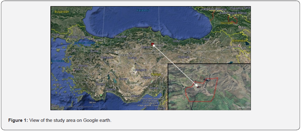
The study area is located in the Çorum-Amasya coal basin. The mine site is located near Küçükçay village, 47 km and 35 km away from the cities of Amasya and Çorum, respectively (Figure 1). The depth of the quarry has reached 50m in the mine site, where production is currently carried out by truck-excavator method.
Geology of the study area
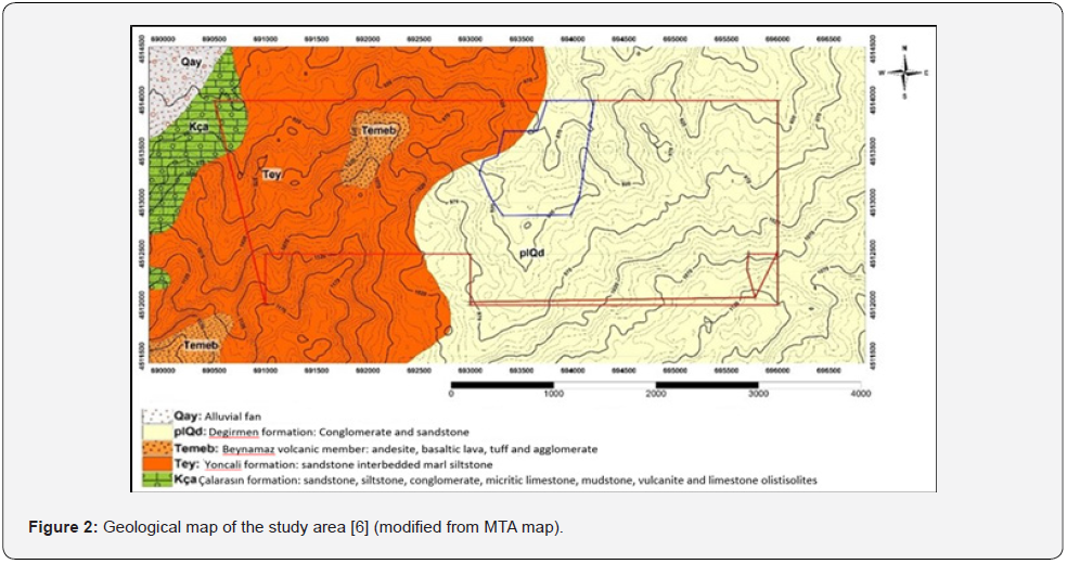
The geology of the study area and its surroundings was investigated by a state-owned mine investigation and exploration institute-MTA. In the study, five different geological formations were defined stratigraphically from young to old or from top to bottom, namely the Alluvial fan (Qay), Degirmen formation (plQd), Beynamaz volcanic member (Temeb), Yoncalı formation (Tey) and Çalarasın Formation (Kça). The geological map of the region, including the license area and the operation area, was modified from the geological map (G34 map) prepared by MTA and shown in (Figure 2). The coal formation extends from the southwest to the northeast and is located within the marl, siltstone and sandstone units called the Eocene aged Yoncalı formation. There is conglomerate, sandstone, siltstone, claystone, mudstone, slope debris and alluvial fan materials of approximately 50 m thickness on the coal seam, which is approximately 25 m thick. As a result of the frequent landslides of these materials in the region, the area was marked as a landslide zone area on the 1/25000 scale topographic map [6].
Hydrology and Hydrogeology of the Study Area Climate
The geology of the study area and its surroundings was A transitional climate prevails between the Black Sea climate and the continental climate in Amasya and its districts. Summers are not as dry as continental climate and not as rainy as Black Sea climate. The winters are not as mild as the Black Sea climate and as harsh as the continental climate. Black Sea climate prevails in this region. The summers are hot and dry, and the winters are rainy. Spring is the season with the most precipitation. Merzifon, Suluova, Gümüşhacıköy and Hamamözü districts reflect the general climatic characteristics of the region. Central district, Taşova and Göynücek districts show more continental climate characteristics. In the meteorological measurements made in the city center since 1937, the annual average precipitation has been measured as 436.7 mm, 418 mm in Merzifon, 458.3 mm in Gümüşhacıköy, 400.0 mm in Taşova, 427.6 mm in Gönücek. In the city centre, the annual average temperature is 13.6 °C, the annual average relative humidity is 61%, the highest temperature was 45.0 °C on 30.07.2000 and the lowest temperature was -20.4 °C on 23.02.1985. July and August are the driest months, and spring is the rainiest season. The annual average number of frost days is 50. The prevailing wind direction throughout the province is the northeastern wind. However, due to the topographic structure of the city center, the 1st degree prevailing wind direction is northwest. The average wind speed is 1.8 m/s, the annual average number of strong windy days is 65 days, the annual average number of stormy days is 12 days. The strongest wind was recorded as 36.0 m/s from the northwest on 24.09.1996. A warm and temperate climate prevails in and around Merzifon district, as in Amasya province. In winter, there is much more rainfall in Merzifon than in summer. According to Köppen-Geiger, the climate is Csb (warm in winter, hot summer and dry climate). The annual average temperature of the Merzifon district is 11,5 °C and the annual average precipitation is 418 mm. The climate table of Merzifon province is shown in (Table 1).

Vegetation
Merzifon is located in a region rich in natural vegetation [7]. Approximately 35% of the district’s lands are covered with forests and heaths. In these tree communities, there are conifers as well as deciduous species. Leaves are usually located in not very high sections. Examples of these are oak, ash and linden. Species such as Scotch pine, larch and fir can be seen at altitudes exceeding 1000 meters. The vegetation of the high areas is mixed forest. In these sections, spruces are concentrated in places. There are no forest areas mentioned in the operation area and its vicinity. In the area where the study area is located, there are meadow pasture vegetation and cereal fields in some areas, while irrigated agriculture and fruit growing are carried out in the plain area towards the town of Alicik.
Streams
The most important stream of Amasya, Yeşilırmak, arises from Köse Mountain of Sivas and merges with the 256 km long Çekerek Stream in Kayabaşı locality within the border of Amasya. Amasya Ezinepazar and Zara Streams flow into Çekerek Stream originating from Yozgat. Before joining Yeşilırmak with Çekerek Stream, it is called Tokat or Tozanlı Water. Tersakan Stream, which comes out of Ladik lake and joins with Gümüşsuyu in Suluova, flows into Yeşilırmak in Amasya. Yeşilırmak passes through Taşova district and flows into Black Sea from Çarşamba District of Samsun. Yeşilırmak is important for Amasya and is used for irrigation. In addition, electricity is produced from the hydroelectric power plants built on Yeşilırmak and its branches. There is Köseler Stream 5 km north of the operation area. There are seasonal dry streams extending from south to north in and around the mine site. Three main dry streams, from which seasonal waters pass through the operation area, pass through the boundaries of the operation area, and these streams were derived and flowed out of the pit.
Water Points-Water Cells
The drinking water need of the Merzifon district is provided by 11 boreholes and the attractive waters coming from the Musruf stream and Şırgayip springs. Approximately 92% of the water fed to the district network is provided from wells. 236 L/s of water is supplied to the district’s mains line, 218 L/s of which is supplied from groundwater and the remaining 8% from 18 L/s spring water. In Gümüşhacıköy district, 20% of the water drawn for urban water supply is spring water and 80% is drilling water. In the villages of Amasya province, 5500 L/s of water was supplied from the drilling and 11250 L/s of water from the springs to be used in 2014 [8]. While there is no continuously flowing source within the operation and license area, it is stated that there are seasonal cells in the settlements.
Hydrogeological Features of Overburden Materials
The geological formations in and around the operation area were explained in detail in the previous paragraphs. The formation units are composed of conglomerate, sandstone, siltstone, claystone and marl units, as can be seen in situ in the field investigations. These units do not show continuity in the mine area and show cross transitions in the form of an alluvial fan. Claystone and marl from these units are hydro geologically impermeable and retain water, while conglomerate, sandstone and siltstone are hydro geologically permeable units.
Groundwater Recharge and Discharge
In our study, the following data were calculated. The large basin, which belongs to the State Hydraulic Works (DSI) and is fed by private water wells, has been calculated as approximately 16,473 hectares. The operating area and the upper precipitation recharge sub-basin is approximately 1001 hectares. The longterm precipitation average of Merzifon Meteorology Station was measured as 418 mm/year. Accordingly, the amount of precipitation falling in the large basin was estimated as 68.857.140 m3. Similarly, the amount of precipitation falling in the sub-basin, which also includes the operation area, was calculated as 4.184.180 m3. Considering the geological units in the region, if the precipitation infiltration rate is taken as 0.35, the groundwater recharge of the entire basin from the precipitation is estimated as 24.099.999 m3/year. Similarly, groundwater recharge from the sub-basin, which includes the operation site and its vicinity, was calculated as 1.464.463 m3/year. Thus, it can be said that 6% of the groundwater in the large basin where the water wells are located is fed from the sub-basin, which also includes the operation area. According to the continuous water withdrawal from all the wells drilled in the plain section, the annual water discharge amount was calculated as 35.805.974 m3/year, using the flow data obtained from the 7th Region of DSI and if it was operated for 6 months. According to these calculations, it is seen that the recharge from precipitation does not coincide with the discharge, and it shows that approximately 11,705,975 m3/year groundwater flows from other side basins to this basin. Excluding water resource discharges, it can be evaluated that the state of the water balance meets the recharge and discharge in the region.
Results and Discussion
Groundwater Situation and Groundwater Level in the Mine Area
Water Wells
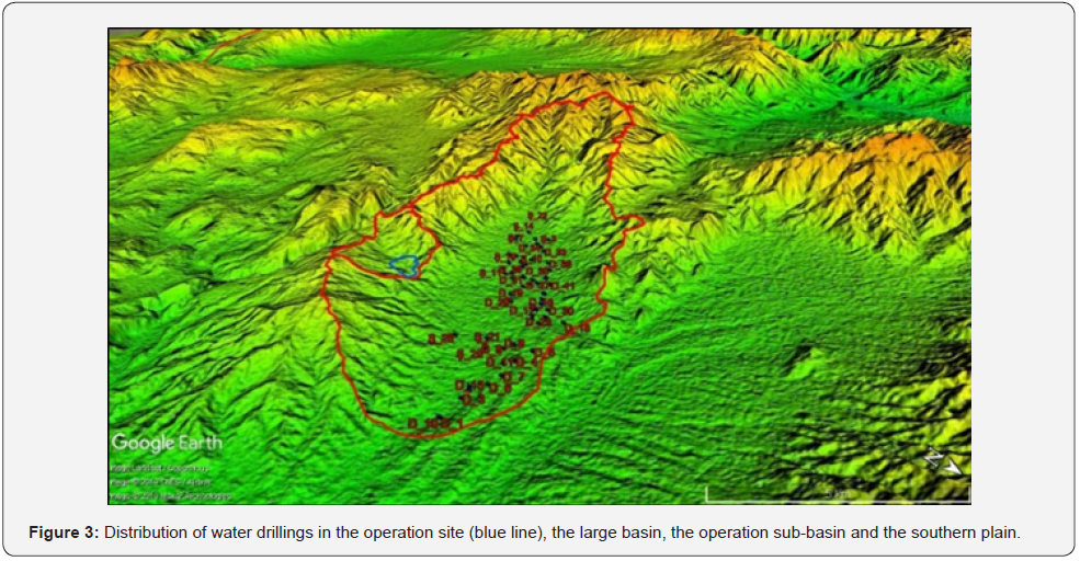
The part of Amasya within the Yeşilırmak basin is divided into 7 sub-basins/plains, namely Merzifon-Gümüşhacıköy plain, Suluova, Taşova, Geldingen plain, Göynücek plain, Mecitözü stream valley and Aydınca plain, considering the hydrogeological characteristics. The Hamamözü Stream Valley sub-basin, which also includes the Hamamözü district, and the Devret valley sub-basin, which stretches along the northwest of the Gümüşhacıköy district, are also within the Kızılırmak basin. Merzifon-Gümüşhacıköy plain is the region where the most groundwater level changes are experienced in the groundwater basins in Amasya [8]. There is no water well in the operation site and its vicinity. However, in the northern part of the field, in the settlements of Ovabaşı, Çitli, Diphacı, Koç, Bulak and Alicik sub-districts, a total of 70 water wells of varying depths have been drilled for use and irrigation, 44 of them by DSI 7th Regional Directorate and 26 of them by individuals. The locations of these drillings and the perspective view of the operational site boundaries are shown in (Figure 3).
Groundwater Level Map and Flow directions
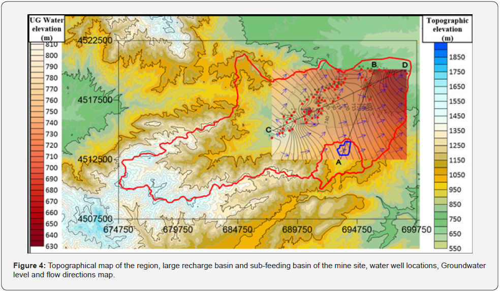
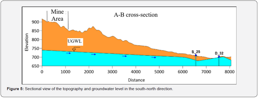
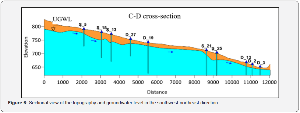
Information such as flow rate, groundwater level and depth of water drillings made in the region were obtained (DSİ, 2015). According to the data obtained, the volume of water wells drilled at 630-850 m elevations in the plains ranges from 2 L/s to 64.32 L/s. Groundwater depth varies between 10 cm and 60 m, and well depths vary between 48 m and 350 m. The closest water drilling to the coal operation license area, which has the lowest base elevation of 845 m, is the well no. Ş_11, which was opened at a distance of 3 km. The mouth elevation of this well is 776m and the static water elevation is 741m at 35m depth from the mouth elevation. In this case, the quarry floor elevations are 104m above the nearest groundwater level. On the other hand, the underground water map of the region was created by using the existing water well elevations in the plain. The precipitation basin, license boundaries, water wells, topography, groundwater level map and water flow directions of the region are shown in (Figure 4) collectively. The A-B section in the south-north direction passing through the quarry is shown in (Figure 5) and the C-D section in the southwest-northeast direction is shown in (Figure 6). When the sections are examined, it is seen that the operation elevations of the mine site are quite above the groundwater level. However, since there are no water wells in the vicinity of the mine site, this interpretation is made according to the water well data in the plain area.
The Effect of Groundwater Condition On Slope Stability Analysis

In the previous section, it was determined that the groundwater level was well below the operating levels. However, since there is no water well in the operation license area, there is no clear information about the groundwater situation in this area. For this reason, the mining direction is to the east, and slope analyses have been made for the three units located in this direction, using the project pressure geometry (width and height: 8 m, step slope angle 60°) on the coal for fully saturated and waterless condition with groundwater. In (Figure 7), as an example, changes in the safety factor calculated according to the Janbu simplified method for the marl unit in the saturated and dry condition are shown. As can be seen from the figure, according to the project step dimensions, the safety factor or safety number for 10 benches is greater than 1 if the environment is completely dry, while the safety number is less than 1 if the environment is completely saturated with water. If the safety factor is taken as 1.3 or 1.5, the number of stable steps decreases to 4 in the saturated state. It is estimated that there is a highly correlated exponential relationship between the number of steps in the saturated and dehydrated condition and the safety factor.
Conclusion
In this study, hydraulic and hydrogeological data were compiled within the scope of a colliery slope stability analysis project located near Merzifon in the Çorum-Amasya coal basin, and the groundwater situation was revealed by using the water well data drilled in the region. The flow rate of the water wells drilled at 630-850 m elevations in the plain part of the region varies between 2 L/s and 64.32 L/s, the groundwater depth varies between 10 cm and 60 m, and the depths of the wells vary between 48 m and 350 m. The closest water drilling to the coal operation license area, which has the lowest base elevation of 845 m, is the well no. S_11, which was opened at a distance of 3 km, and the static water level here is estimated to be 104 m below the quarry floor elevations. By using the existing water well elevations in the plain, the groundwater map and sections of the region were created, and it was seen that the operation elevations of the mine site were well above the groundwater level. However, since there are no water wells in the vicinity of the mine site, this interpretation was made according to the water well data in the plain area. In the mine operation, the quarry is currently progressing towards the east, and slope analysis were made with the Janbu simplified method, using the project pressure geometry for the dry and fully saturated state of the lithological units in this direction. Accordingly, according to the project step dimensions for the marl unit, the safety factor or safety number for 10 steps is greater than 1 if the environment is completely dry, while the safety number is less than 1 after the 7th step if the environment is completely saturated with water. If the limit value of the safety factor is taken as 1.3 or 1.5, the number of stable digits decreased to 4 digits in the saturated state. A highly correlated exponential inverse relationship was estimated between the number of steps in the saturated and dehydrated condition and the factor of safety. In the observations made in the field, it is thought that the soil flow and landslides occurring in the quarry are mostly due to seasonal excessive precipitation. It is recommended to conduct an appropriate number of water drillings in the quarry site to determine the groundwater situation, especially in the direction of mining production progress.
Acknowledgement
The authors would like to thank HMY Mining Company for their assistance in the field studies.
References
- Hoek E, Bray JW (1981) Rock slope engineering. Third edition The Institution of Mining and Metallurgy, Stephen Austin, Sons Ltd, London, UK pp: 358.
- Terzaghi K (1925) Earthwork mechanics based on soil physics. Deuticke, Vienna, Austria.
- Ekmekçi M (2015) The Importance of Hydrogeological Conceptualization and Characterization in the Solution of Groundwater Problems at Excavation Sites: Examples from Turkey. MUHJEO 2015: National Engineering Geology Symposium, 3-5 September, KTU, Trabzon, 467-474.
- Atkinson LC (2001) The Role and Mitigation of Groundwater in Slope Stability. Slope Stability in B.C, Canada.
- Hoek E (2000) Rock engineering. Course Notes, E. Hoek Consulting Engineer Inc., North Vancouver, Canada.
- MTA 2013. 1/100 000 Scale Geological Maps of Turkey, No:184, ÇORUM G34 MAP, Mustafa Sevin & Mehmet Fuat Uğuz, Department of Geological Studies, Ankara. 24h.
- https://tr.climate-data.org/asya/tuerkiye/amasya/merzifon-15863/
- Anonymous (2017) Amasya Province 2017 Environmental Status Report, Amasya Governorship Environment and Urbanization Province DSI, 2015. 7th Regional Directorate, Samsun.


