The Importance of Neighbourhood for Urban Resilience
Chiara Ortolani*
Department of Civil, Building and Environmental Engineering, Sapienza University of Rome, Italy
Submission: July 26, 2017; Published: August 22, 2017
*Corresponding author: Chiara Ortolani, Department of Civil, Building and Environmental Engineering, Sapienza University of Rome, Living the City Lab, Italy, Tel: +39-3281886091; Email: chiara.ortolani@uniromal.it
How to cite this article: Ortolani C. The Importance of Neighbourhood for Urban Resilience. Civil Eng Res J. 2017; 1(3): 555562. DOI: 10.19080/CERJ.2017.01.555562
Abstract
Encouraging the active mobility and implementing the urban resilience are two issues closely linked each to other but, at the same time, it is hard to get them together, conceivably because we are trying to find the answers by using unsuitable or inadequate scales. Several urban studies took in consideration the neighbourhood dimension as a basic unit. At this scale it is possible to increase the relationship between people and the territory by increasing the pedestrian and cycling accessibility of urban space also. Connectivity is an important feature that our cities are losing with a negative impact on their resilience. The main aim of this work is to highlight the role of the neighbourhood scale in order to encourage an active mobility and to implement a real transition towards a resilient city.
Results highlighted that neighbourhood represents a suitable dimension where inhabitants are able to easily identify problems, weaknesses, opportunities, personal and collective needs and possible solutions. Furthermore, this approach contributes to promote a greater knowledge of the territory and awareness of the dynamics that affect it among residents. Consequently, this approach contributes to a wider participation to public decisions concerning the choice, reduction of the car-based mobility and increase of the pedestrian and cyclist mobility and, as a consequence, the implementation of the urban liveability and resilience.
Keywords: Urban mobility planning; Neighbourhood plan; Citizens participation; Connectivity
Abbreviations: NeP: Neighbourhood Plan; DUMP: Detailed Urban Mobility Plan
Introduction
Encouraging the active mobility and implementing the urban resilience are two issues closely linked each to other but, at the same time, it is hard to get them together, conceivably because we are trying to find the answers by using unsuitable or inadequate scales. Studies demonstrated that connectivity is an important feature that our cities are losing causing negative impacts on their resilience [1,2]. It is derived by social relationships among individuals and between people and the overall urban spaces. The reconstruction of social and spatial connectivity both locally and at urban level could be made by considering the city as a set of defined and tightly interconnected cells are collaborating each to other.
It is worth to note that basic cells may be represented through the neighbourhoods, because this spatial dimension is suitable for the everyday needs of residents. Furthermore, residents can across it on foot or biking, representing thus an important framework for socializing and contributing to promote a greater knowledge of the territory and awareness of the dynamics that affect it. Several urban studies took in consideration the neighbourhood dimension as a basic unit of an ensemble of public interconnected open spaces which constitutes the system of places that have value for residents [3-5]. Other urban planning and transport studies took in consideration other unitary urban dimensions, similar to neighbourhood dimension or part of this: "Environmental Area (EA)" [6-9], "Elementary Urban Unit" [10] and "Supermanzana" [11].
The social and spatial connectivity is the basis for a new culture of the city (Samaniego & Moses 2008). The higher capacity of interconnection among components (i.e. people and spaces) of a system is, the greater is the difficulty to break it down, and better is the resilience of the system [2,12]. In this way, connectivity can be restored in order to have an urban system much more resilient. To re-build connectivity is necessary to get a systemic vision in the frame of urban intervention. For this reason, it is necessary to refer at a dimension that should be both meaningful and under control for public administration and inhabitants that is the neighbourhood. Within the neighbourhood dimension it is possible:
- To have a systemic vision and, as a consequence, reconstruct the links among different areas of intervention (mobility, urban areas, street trees and other);
- To have clear territorial features and their implications that may not be visible at a larger scale;
- To involve citizens about topics of their interest and competence. As a result of these features, the Neighbourhood Plan can be a valuable tool because it allows a capillary analysis of the territory and allowing also one or more scenarios that take into account local resources thereby increasing local connectivity and resilience.
It provides a complex vision and it is able to integrate both the needs and the actions in the individual neighbourhood and the needs and actions at the urban level. If we consider the transport sector, which has a great impact on reducing resilience and connectivity, through the use of the NeP we can put in place useful measures to enhance active mobility, reduce the use of private cars on short distances (<5km) and proximity (<2km), reduce air pollution, reduce soil waterproofing, reduce the number and severity of road accidents and increase liveability and urban resilience.
Objective of the Paper
To highlight the importance of the neighbourhood scale to encourage active mobility and to implement a real transition towards a resilient city is the main aim of this work. The approach described here is the result of experimentation driven in the test area of Osteria del Curato neighbourhood, located inside a wider study area (metropolitan area of Rome).
Methodological Approach
A Neighbourhood Plan (NeP) is not a plan or a project, but it is a scenario, that is a program of actions and interventions useful for improving the living conditions into the neighbourhoods of the cities through interventions on the public space [13]. The NeP is elaborated throughout the active participation of citizens. It can be promoted by Municipality Administration or public committees and associations (autonomous participation). The draft of plan is organized and driven by a coordination group, which has the role of third actor between Public Administration and citizens. Therefore, NeP is an innovative and necessary tool; it can fills up the gap of traditional urban planning tools, and it is related to the achievement of an open public spaces system and to the management of their liveability.
Realistically, NeP puts in the foreground the open public space and includes the interventions discussed by citizens, technicians and Municipality Administration during the working groups. These interventions are mutually integrated in order to constitute a cohesive and unified local urban structure. The absence or incompleteness of this structure is generally one of the most important problems concerning the quality of the open urban spaces and, as a consequence, for the neighbourhood liveability. The NeP training path, instituting a participatory dialogue among different stakeholders (citizens, associations, directors, economic operators and private entrepreneurs, technicians), can facilitate a satisfactory consultation of the choices and hence it can be taken as a base line to training a Complex Program such as the Integrated Intervention Program. The scenario of interventions defined by a NeP prefigures a system of actions arranged without a priority order, which can be implemented gradually as soon as the relevant technical and economic feasibility conditions are fulfilled. Therefore, a NeP can be modified or revised if needs are effective [6].
Innovative Aspects and Final Considerations
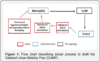
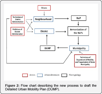
Nowadays, the Detailed Urban Mobility Plan (DUMP) is originated from the Central Administration that has to meet needs of the over-all Districts (and their neighbourhoods) but, at the same time, it has a low knowledge of territories and did not involve citizens within the process (Figure 1) because they are considered only final users. The result is the following: it is possible to schedule a unified plan but few sporadic projects only. As an alternative, during the draft of the NePs, citizens instead represent a very important component within the process that is focused on realization of these plans (Figure 2). In this way, the process starts from the Districts that, by involving the neighbourhoods and the Neighbourhood's assemblies, provide the necessary data (density, population, location and severity of road accidents). Where upon, District assemblies draw the NePs and deliver them to the reference District. The reference District brings NePs together harmonizes and transmits them to the relevant central offices (i.e. Department of Transport and/ or Mobility Agency). Technicians' of both reference District and the relevant central offices jointly analyze the NePs. In the case of observations and objections, NePs are sent back to Districts and Neighbourhood’s assemblies and are discussed again on the basis of the comments / objections made. Therefore, if there are no observations or objections, the information contained in the NePs serves to define the DUMP (Figure 2).


In this way problems, opportunities and resources are analyzed by using a systemic approach. This systemic vision allows to realize a more complex and shared plan, to propose an unitary plan of action, to put in place the better economic and technical scheduling and, finally, to root the process for building of DUMP in each neighbourhood. In fact, NePs are able to represent in a better way all needs and the potentials of each neighbourhood. This process makes both technical and cultural advantages, due to the increase of the participation and awareness of citizens and to the increases of quantity and quality of local relations between people and territory [14]. Although this study case is focussed on the city of Rome, it is obvious that this process can be replicated in cities of similar, inferior or greater size.
References
- Capra F (1996) The Web of Life. Doubleday-Anchor Book, New York, USA.
- Ortolani C (2013) urban morphology, transport and energy: allometric theory and impact indicators. Proceedings of the City, Memory, People. 9th Congress of Virtual City and Territory, Italy.
- Lynch K (1960) The image of the city. Cambridge Massachusetts: MIT Press, Cambridge, USA.
- Castells M (1997) The Information Age: Economy, Society and Culture. The Rise of the Network Society. The power of identity. Wiley- Blackwell, Malden, Massachusetts, USA.
- Colarossi P (2008) Elementi di estetica urbana. In: Colarossi P & Latini AP (Eds.), La progettazione urbana. Edizioni del Sole 24 Ore, Milan, Italy, pp. 71-430.
- Buchanan C (1963) Traffic in Towns. A study of the long term problems of traffic in urban area. Reports of the Steering Group and Working Group appointed by the Minister of Transport, HMSO, London, England, p. 223.
- NZ Transport Agency (2009) Pedestrian planning and design guide. New Zeland.
- SWOV-Institute for Road Safety Research (2010) SWOV Fact sheet. Zones 30: urban residential areas. Netherlands.
- Ortolani C (2014) Modelli urbani: relazioni tra struttura, forma del tessuto connettivo e sistema della mobilità. Proceedings of the XVII Conferenza Nazionale SIU, l'Urbanistica italiana nel mondo. Italy.
- Vittorini M (1988) Il Rinascimento della citta. Quaderni del DPTU- Department of Territorial Planning and Urban Planning, University La Sapienza, Rome, Italy.
- Rueda S, Jennifer C, Cynthia E, Manual G, cristian G, et al. (2008) Plan Especial de Indicadores de Sostenibilidad Ambiental de la Actividad Urbanistica de Sevilla.
- Casti Jl (1977) Complexity, connectivity and resilience in complex Ecosystems. IFAC Symposium on Bio- and Ecosystem, Germany
- Cappuccitti A, Colarossi P, Ortolani C, Romano R (2015) Spazio pubblico, partecipazione, mobilità dolce: Piano di Quartiere per Osteria del Curato, Roma. Proceedings of the 9° INU Study Day Green and Blue Infrastructures, Virtual, Cultural and Social Networks, Italy
- Ortolani C, Vitale M (2016) The importance of local scale for assessing, monitoring and predicting of air quality in urban areas. Sustainable cities 26(2016): 150-160.


